Appendix H: Bike Plan
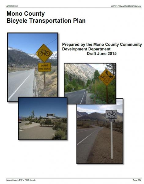
TABLE OF CONTENTS
Summary.
Chapter 1: Introduction. 233
Chapter 2: Needs Assessment 237
Chapter 3: Policies. 246
Chapter 4: Demand for Bicycle Facilities. 254
Chapter 5: Proposed Bikeway System.. 260
Chapter 6: Funding, Implementation, and Phasing. 268
Appendix A: References. 271
Appendix B: Emails from Bicycling Groups. 273
Appendix C: Maps. 277
TABLE OF TABLES
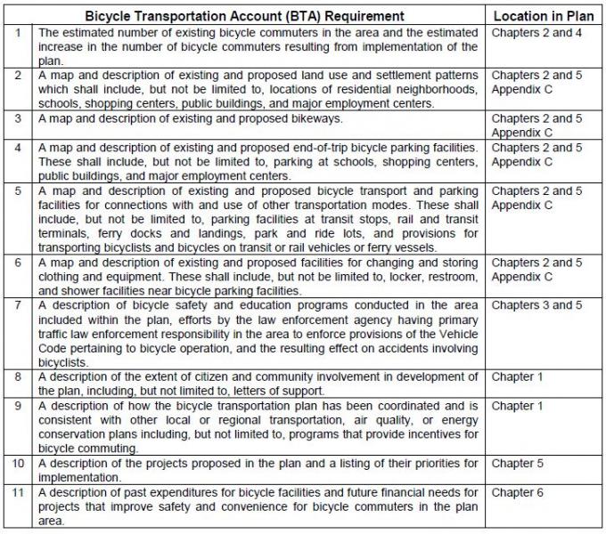
TABLE 1. Required Components of a Bicycle Transportation Plan. 232
TABLE 2. Mono County Population Estimates, 2015. 255
TABLE 3. Mono County Population Projections, 2020-2040. 255
TABLE 4. Mono County Community Population Projections, 2010-2040. 256
TABLE 5. Travel Time to Work, Workers 16 & Older by Planning Area, Mono County, 2000. 258
TABLE 6. Potential Projects. 262
TABLE 7. Estimated Costs for Potential Bikeway System.. 268
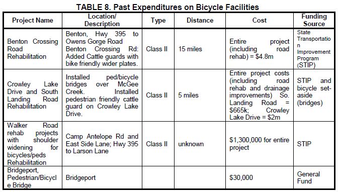
TABLE 8. Past Expenditures on Bicycle Facilities. 269
TABLE OF FIGURES
FIGURE 1. Examples of Bikeway Types in Mono County. 240
FIGURE 2. Example of Bicycle-friendly Cattle Guard on Benton Crossing Road. 242
FIGURE 3. Antelope Valley Bike Facilities Map. 278
FIGURE 4. Bridgeport Valley/Twin Lakes Bike Facilities Map. 279
FIGURE 5. Bridgeport Community Bike Facilities Map. 280
FIGURE 6. Lee Vining Community Bike Facilities Map. 281
FIGURE 7. June Lake Loop Bike Facilities Map. 282
FIGURE 8. Long Valley Bike Facilities Map. Error! Bookmark not defined.
FIGURE 9. Benton Community Bike Facilities Map. 284
Summary
Caltrans Bicycle Transportation Account (BTA) Cross-Reference
Prior to the Active Transportation Program (ATP), a Bicycle Transportation Plan (BTP) was required for county’s to qualify for funding from the state Bicycle Transportation Account (BTA) administered by the Caltrans Bicycle Facilities Unit (BFU). The BTA has since been integrated into the ATP, but this BTP continues to comply with the required components from California Streets and Highway Code Section 891.2. Eventually, the BTP may be integrated into a Mono County ATP Plan. The Mono County Bicycle Transportation Plan includes each of the required components, as follows:
TABLE 1. Required Components of a Bicycle Transportation Plan
Chapter 1: Introduction
Purpose of Plan
The Mono County Bicycle Transportation Plan is the bicycle transportation plan for the unincorporated area of Mono County. The only incorporated area in Mono County, the Town of Mammoth Lakes, has its own Bicycle Transportation Plan and thus it is not a part of this document. This Plan has been developed in compliance with California Streets and Highways Code Sections 891.2 and 891.4 and in compliance with the requirements for state Bicycle Transportation Account (BTA) funding applications. The Plan further develops the General Bikeway Plan contained in the Mono County Trails Plan (1994) and has been designed to complement similar plans in surrounding counties and communities. The Plan includes the following components:
- Describes existing bicycle facilities and programs in Mono County;
- Analyzes the need for future facilities and programs in the county;
- Designates new routes and prioritizes their development;
- Provides maps for existing and proposed bikeways;
- Establishes policies and standards for the improvement of bicycle facilities and programs; and
- Identifies funding sources and establishes implementation goals for prioritized projects.
Policies in the document recommend that the Mono County Bicycle Transportation Plan should be reviewed and updated every five years, in compliance with state requirements for Bicycle Transportation Account (BTA) funding and to ensure that the plan remains current.
Planning Area
Mono County is a sparsely populated rural county located on the eastern side of the Sierra Nevada mountain range. The State of Nevada forms the county's eastern border. Approximately 94 percent of the county's 3,103 square miles are publicly owned; the area's spectacular scenery of high valleys and rugged mountain ranges has made it a popular recreation destination. The major population center, and the County's only incorporated area, is the Town of Mammoth Lakes. The remainder of residents are scattered in small communities throughout the county.
Communities in the county include Topaz, Coleville and Walker in the Antelope Valley; Bridgeport, the County seat, in the Bridgeport Valley; Mono City and Lee Vining in the Mono Basin; June Lake along the June Lake Loop; Long Valley, McGee Creek, Crowley Lake, Aspen Springs and Sunny Slopes in Long Valley; Swall Meadows and Paradise in the Wheeler Crest area; and Chalfant, Hammil and Benton in the Tri-Valley area.
Mono County is a recreation destination. Throughout the year, there is a significant tourist population in many of the county’s communities and at various recreation destinations such as Mammoth Mountain Ski Area, June Mountain Ski Area, Mono Lake, and Bodie.
Mono County Highways
The state and federal highway system provides the major access to and through Mono County, connecting communities in the county and providing access to and from the county.
- US 395 is the major transportation route in the county. It connects the Eastern Sierra with Southern California and with the Reno/Tahoe region in Northern Nevada. US 395 is also Main Street in Lee Vining, Bridgeport, Walker, Coleville, and Topaz.
- US 6, from the Inyo County line north of Bishop to the Nevada state line, connects the Tri-Valley communities of Benton, Hammil, and Chalfant to Bishop and Inyo County. US 6 is also Main Street in the Tri-Valley communities.
- SR 89 provides access from US 395 to Monitor Pass and is closed in the winter.
- SR 108 provides access from US 395 west to Sonora Pass and is closed in the winter.
- SR 120 provides access from US 395 west to Tioga Pass and east to Benton. The western segment is closed in the winter and the eastern segment may also be closed briefly.
- SR 158, the June Lake Loop, provides access from US 395 to the community of June Lake and is Main Street throughout the June Lake Loop. A portion of SR 158 is closed in the winter.
- SR 167 provides access from US 395 to the Nevada State Line, north of Mono Lake, and access to the community of Mono City.
- SR 168 provides access from US 395 at Big Pine in Inyo County north to Oasis in the southeast corner of Mono County.
- SR 182 provides access from its junction with US 395 in Bridgeport northeast to the Nevada state line and provides the main street access to a portion of the community of Bridgeport.
- SR 203 provides access west from US 395 to Mammoth Lakes.
- SR 266 provides access through Oasis in the southeast corner of the county.
- SR 270 provides access east from US 395 to Bodie State Historic Park and is closed for a portion of the winter.
Mono County Roads
The County currently has 684.15 miles of county maintained roads. Of that maintained mileage, 179.07 miles are paved, 168.47 miles are plowed in the winter, and 197.87 miles traverse National Forest lands. Most of the County roadway system is already established, and the priority is on maintaining the existing circulation system. The need for new facilities are generally addressed in the community policy section (e.g. June Lake) in order to complete the circulation system, alleviate congestion and provide for continued growth. The main access to all communities in the county is state highways, i.e. Highways 395, 158, and 6.
In addition to County roads, there is an extensive network of private and federally controlled roads in the county, many of them unimproved. The federal roads, on lands managed by the Forest Service and Bureau of Land Management, are mostly unmaintained dirt roads that receive limited use from logging trucks, off-highway vehicles (OHVs), mountain bikers. The Forest Service and the BLM have developed management plans for OHV use. The private roads in the county are mostly in community areas and are either substandard roads that do not meet the County Roadway Standards and as a result have not been accepted into the County Roadway Systems, or newer roads established as a part of subdivision development that are maintained by entities such as County Service Areas that are funded by the landowners served.
The transportation systems serving the Bridgeport Indian Colony and the Benton-Paiute Reservation include county roads, tribal roads, and roads managed by the Bureau of Indian Affairs. Transportation needs for each location include road upgrades, ongoing road maintenance, and new road construction to serve existing and proposed development (see Bureau of Indian Affairs, Benton-Paiute Reservation Transportation Plan; Bridgeport Indian Colony Transportation Plan).
Community Participation in Plan Development
Community participation in the development of the Mono County Bicycle Transportation Plan was widespread. Comments received from the following sources have been incorporated into the plan.
Staff made presentations to the following groups to elicit comments on the plan:
- General Public: Staff made presentations at the county’s nine community and Regional Planning Advisory Committees seeking input. These local planning groups work with the county on a variety of planning and development issues. The groups are composed of local residents, along with some local representatives of federal and state agencies.
- Collaborative Planning Team: The Collaborative Planning Team is a multi-agency planning team, consisting of local, state, and federal agencies, which focuses on a variety of planning and resource use issues in the Eastern Sierra. Members include Mono County, the Town of Mammoth Lakes, the Bureau of Land Management, the Lahontan Regional Water Quality Control Board, the California Department of Fish and Game, Caltrans, the Los Angeles Department of Water and Power, the Inyo National Forest, the Humboldt-Toiyabe National Forest, the Benton Paiute Reservation, and the Bridgeport Indian Colony.
Staff contacted the following groups to elicit input on the plan:
- Schools: Eastern Sierra Unified School District and Mammoth Unified School District.
- Bridgeport Indian Colony.
- Benton Paiute Reservation.
- Bodie State Park.
- USFS: Inyo National Forest and Humboldt-Toiyabe National Forest.
- Bureau of Land Management: Bishop Office.
- Bike groups: East Side Velo Club and the Sierra Cycling Foundation.
Consistency with Local Plans
Caltrans
Mono County is located in Caltrans District 9, which operates and maintains all state and federal highways in the county. The district has a bicycle coordinator and a bicycle page on the district website that includes bicycle route maps for the area and route elevation profiles linked to the roadway map (see www.dot.ca.gov/dist9/).
Mono County General Plan
The Bicycle Transportation Plan (BTP) has been developed to be consistent with applicable policies in the Mono County General Plan Circulation Element. The Plan will be attached as an appendix to the Regional Transportation Plan, which is part of the Circulation Element of the General Plan.
Mono County Local Transportation Commission
The BTP has been developed to be consistent with applicable policies in the Mono County Regional Transportation Plan (RTP). The Plan will be attached as an appendix to the RTP.
Bureau of Land Management (BLM)
The BLM actively plans local and regional bikeways on federal lands under its jurisdiction in Mono County. Recreation planners focus primarily on mountain biking and hiking trails for recreational use. Trails and bikeways that could be used as connectors to communities have been incorporated into this plan.
US Forest Service (USFS)
The BTP has been developed to be consistent with applicable policies in the Land and Resource Management Plans for the Inyo National Forest and the Toiyabe-Humboldt National Forest, as well as the management plan for the Mono Basin National Forest Scenic Area.
Inyo County
The BTP has been developed to be consistent with applicable policies and maps in the Inyo County BTP.
Town of Mammoth Lakes
The BTP has been developed to be consistent with applicable policies and maps in the Town of Mammoth Lakes Draft Mobility Element and General Bikeway Plan (2014).
Chapter 2: Needs Assessment
This chapter provides information on existing bicycle facilities in Mono County, including regional and multimodal connections and support facilities and programs. It then identifies Needs and Opportunities for bicycle facilities and programs throughout the county.
Mono County Bikeway Facilities
The unincorporated area of Mono County, outside of the Town of Mammoth Lakes, has few existing bicycle facilities.
Existing Bicycle Routes and Signage
Although cycling is an increasingly popular activity in Mono County, the county lacks facilities specifically for bicyclists. Most cycling occurs on roadways where the shoulder may or may not be wide enough to accommodate bicyclists safely. Mountain bike use occurs throughout the county on dirt roads, which generally are not marked as bike trails. The following are the sections of local roads with markings/signage for bike use:
- Bike Route along Crowley Lake Drive and South Landing Road from Tom’s Place to Crowley Lake
- Bike Route along Pearson Road in Crowley Lake
- North Shore Drive Bike Route in June Lake
- Share the Road signs along Benton Crossing Road
- Share the Road signs along SR 158 in June Lake
- Bicycle/pedestrian bridge over the East Walker River in Bridgeport
- Recently designated bike lane on Main Street (Hwy 395) in Bridgeport
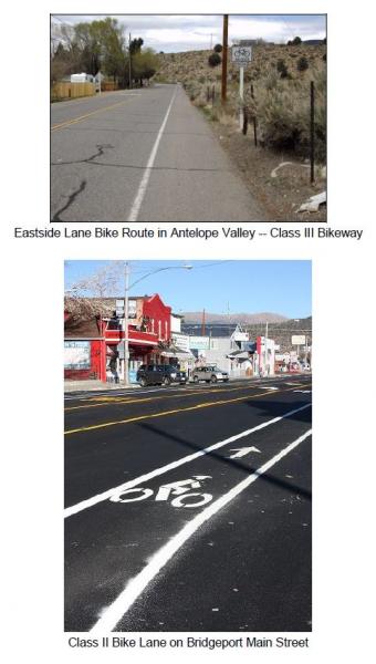
- Eastside Lane Bike Route in the Antelope Valley
Existing Rest Facilities
Rest facilities (e.g. restrooms, drinking water, public phones, and air for tires) and parking facilities (for vehicles and bicycles) are available in most communities at the community center, at private facilities in communities, at schools, at county parks, and at U.S. Forest Service facilities.
Outside of communities, rest facilities and parking facilities are available at U.S. Forest Service facilities (campgrounds and recreational areas), and at private recreational areas (e.g. Twin Lakes, Brown's Campground on Benton Crossing Road, etc.). There are few rest facilities on the many dirt roads in the county used by bicyclists. Most of those roads are on public lands and the applicable land management policy for those areas is generally to keep them as undeveloped recreational areas.
The Eastern Sierra Scenic Byway provides rest facilities along the length of US 395 in Mono County and along SR 120 between Yosemite National Park and US 395.
Existing Parking Facilities
- Bike racks are located at the following locations:
June Lake Library and Community Center
USFS Mono Basin Visitor Center in Lee Vining
Behind Mono Mart in LV for employees
County Annex building in BP
Lee Vining High School
Lee Vining Community Center
Changing Facilities
- No facilities specifically exist for bicycle riders to change clothing (changing facilities) except for restrooms adjacent to the bike racks mentioned above.
Transport Facilities/Public Transit Connections
- All Eastern Sierra Transit buses have bike racks. Shelters have recently been installed at bus stops in communities throughout the county, however, the shelters are not equipped with bike racks.
Bus shelters have been installed in the following locations:
- Crowley Lake Drive, just north of Tom’s Place store
- Community Center in Crowley Lake
- Chalfant at the Community Center
- Lee Vining, in front of the Caltrans Yard and on Hwy 120 at the Mobile Mart (this is a YARTS stop)
- Walker, US 395 southbound near the County Store
- Bridgeport, on Emigrant Street next to the County Park Tennis Courts
Mono County Bicycle Users
The unincorporated area of Mono County, outside of the Town of Mammoth Lakes, has few existing bicycle facilities. With job centers and school locations often outside their community, it is not practical for most people to commute to work on bicycles or for many students to commute to school using bicycles. Both students and workers must often drive many miles to their destination, to a community other than the one in which they reside. However, this gap appears to be closing. The 2009-2013 American Community Survey 5-year Estimate by the U.S. Census Bureau estimates just over a 16 minute mean travel time to work (http://factfinder.census.gov/faces/tableservices/jsf/pages/productview.xhtml?src=bkmk), indicating a more reasonable distance to commute by bicycle. Extreme weather conditions also make it difficult to bicycle year-round; snow and ice in many parts of the county limit winter biking opportunities, while extreme heat and dust storms decrease summer biking opportunities in other areas.
Interest in commuting by bicycle is growing within communities. There is generally limited traffic congestion, and air quality impacts from automobile use are minimal in the county. Bicycling within Mono County communities is a viable opportunity because most Mono County communities are small, with relatively flat topography. Opportunities for recreational bicycling are abundant. Many of the county’s paved roads have little traffic and lead to a variety of scenic recreational destinations.
The County currently has no estimates on the number of existing bicycle commuters in the area, nor the numbers of school children who ride to school. Anecdotal data suggests that numbers for both categories are small. The 2009-2013 American Community Survey 5-year Estimate by the U.S. Census Bureau does not provide a category for bicycle commuters, but does estimate that 13.9% of the population walk to work and 4.5% utilize other transportation means (see http://factfinder.census.gov/faces/tableservices/jsf/pages/productview.xhtml?src=bkmk).
Recreational Use/Bicycling Events
Recreational biking is an increasing tourist attraction in the County, both on county roads and highways and on unpaved roads on public lands. The local cycling community currently produces several large-scale bike event on roads within the County, including the Mammoth Gran Fondo, Everest Challenge, and Pamper Pedal, among others. The Sierra Cycling Foundation has indicated that organizers would like to attract more large scale biking events to the County.
Safety and Education Programs
Several entities within Mono County conduct bicycle safety and educational programs.
- The Mono County Health Department sponsors bicycle safety activities throughout the year in conjunction with other county and town agencies. There are a limited number of bicycle helmets available for children whose families cannot afford to buy one.
- The Town of Mammoth Lakes Police Department continues to have an ongoing program of bicycle safety and education primarily oriented toward elementary school-aged children. The program includes a yearly “Bicycle Rodeo” for all grades, bicycle inspection, bicycle safety handouts, and bicycle registration. The Bicycle Rodeo focuses on riding safety and instruction, helmet use, traffic sign recognition, bicycle lane use, handling cross-walks, hand signals, etc. Bicycles are checked for safety features such as seats, handlebars, brakes, and tires; a special sticker is issued showing inspection. The program is conducted on a yearly basis. Safety handouts are also available for younger children in the first and second grades.
- Sierra Cycling Foundation’s mission is to promote cycling and improve cycling conditions in the Eastern Sierra. SCF advocates bicycle safety and education of cyclists as well as motor vehicle operators. The group strongly supports the “share the road” concept and continually strives to add more miles of “share the road” signs. SCF provides bicycle safety information and suggested routes and rides for cyclists visiting and living in the Eastern Sierra and emphasizes bicycle-safety training for children, mandatory helmet laws, and safer road conditions by working with public works and planning departments in Inyo and Mono counties, the Town of Mammoth Lakes, the city of Bishop and Caltrans, District 9.
- Eastside Velo is a bicycle club registered with the United States Cycling Federation, with about 270 members in 2015. The club organizes rides and events, including the Mammoth Gran Fondo, and is an advocate for road biking in the Eastern Sierra.
Types of Bikeways
The Caltrans Highway Design Manual identifies four types of bicycle facilities:
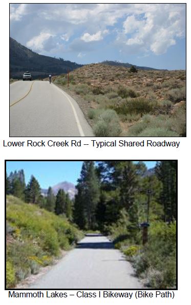
- Class I Bikeway (Bike path). Separate right-of-way for bicyclists. Generally should serve corridors not served by streets or highways.
- Class II Bikeway (Bike lane). Utilizes the shoulder area of roads. Signing and striping separate areas for bicyclists and motorists.
- Class III Bikeway (Bike route). Similar to a Class II Bikeway, except that the shoulder area is shared with vehicles.
- Shared Roadway (No bikeway designation).
Most of the facilities in the county are Shared Roadways. There is a short Class II Bikeway along Crowley Lake Drive in the vicinity of Aspen Springs and on Bridgeport Main Street. There are also marked mountain bike routes on dirt roads in the western end of Long Valley.
Selection of the appropriate type of bikeway to meet an identified need is dependent on many factors, including safety, demand, and connection to other bike facilities. The Caltrans Highway Design Manual contains criteria to help determine whether designation of a bikeway is appropriate and, if so, which type is most suitable. The relative cost of various types of facilities is also a consideration.
In Mono County, shared roadways (with a 4-foot paved shoulder and 4-inch edge stripe) will continue to be the most feasible type of bikeway in most areas. Relatively low bicycle demand may make it infeasible to designate bikeways; environmental considerations and maintenance costs may make it difficult to develop separate bike paths.
Caltrans’ Requirements to Provide for Bicycle Use
Caltrans is required to provide adequate width for shared use by motorists and bicyclists on new construction and major reconstruction projects. On resurfacing projects, the entire paved shoulder and traveled way must be resurfaced and when adding lanes or turn pockets, a minimum 4-foot shoulder must be provided. These requirements will result (or has resulted) in the development and maintenance of a minimum 4-foot paved roadway shoulder with standard 4-inch striping on many portions of the highway system in Mono County.
Since highways in Mono County receive relatively limited use by bicyclists, it may be inappropriate to designate them as bikeways, particularly since Caltrans' requirements are resulting in adequate on-road facilities. However, special consideration should be given to the placement of rumble strips to better accommodate cyclist needs; the need for regular maintenance of shoulders to ensure safe riding conditions; and pavement surface in rehabilitation projects to ensure conditions suitable for cyclists.
Planning and Design Standards
The Caltrans Highway Design Manual establishes bikeway planning and design in California. Section 1001.2 of the Manual discusses the role of bikeways as “one element of an effort to improve bicycling safety and convenience – either to help accommodate motor vehicle and bicycle traffic on shared roadways, or to complement the road system to meet needs not adequately met by roads.”
Streets and Highway Code Section 890.4 defines a “bikeway” as a facility that is provided primarily for bicycle travel and identifies the three types of bikeways listed above: Class I, II and III bikeways (see Figure 1).
FIGURE 1. Examples of Bikeway Types in Mono County
The Design Manual also notes a fourth type of bikeway facility – the Shared Roadway with No Bikeway Designation. Most bicycle travel in the state, and in Mono County, occurs on streets and highways without bikeway designations. The Manual (Section 1002.1) notes that:
Many rural highways are used by touring bicyclists for intercity and recreational travel. It might be inappropriate to designate the highways as bikeways because of the limited use and the lack of continuity with other bike routes. However, the development and maintenance of 4-foot paved roadway shoulders with a standard 4 inch edge line can significantly improve the safety and convenience for bicyclists and motorists along such routes.
Selection of the appropriate type of bikeway to meet an identified need is dependent on many factors, including safety, demand, and connection to other bike facilities. The Caltrans Highway Design Manual contains criteria to help determine whether designation of a bikeway is appropriate and, if so, which type is most suitable. The relative cost of various types of facilities is also a consideration.
Countywide Needs Identified by Local Bicycle Groups
Local bicycling groups, including Eastside Velo and the Sierra Cycling Foundation, have identified several overall needs related to biking in unincorporated Mono County.
- Uphill Bike Lanes
Widening uphill shoulders is the single most important step to achieve consistent auto flow travel, cycle safety and construction economics (build lanes uphill only). Widening uphill sections on the Scenic Loop, Crowley Lake Drive, Benton Crossing Road, lower and upper Rock Creek Road and Highway 120 would be a sensible, economical start.
- Maintenance
Existing roads and shoulders should be maintained. Expansion cracks need to be filled and smoothed with special attention to downhill lanes. Benton Crossing Road and the Scenic Loop are examples of downhill stretches of roads in need of crack filling.
- Cleanliness
Road shoulders should be swept, with uphill sections swept most frequently. Uphill roads with banks and curbs need vacuum-type sweeping rather than pull-broom as the banks trap debris. Major holidays yield more glass and debris.
- Signage
Signs, which indicate cycle traffic, give a heads-up to both cyclists and motorists. "Share the Road" signs on 2-lane roads are an inexpensive yet effective way to create safety for all. "Share the Road" signs would be well suited for the Scenic Loop, Crowley Lake Drive, Twin Lakes Road and Benton Crossing Road. Bike Route signs on SR 203, and on US 395 from Tom's Place to June Lake and eventually to Lee Vining would be ideal.
- Rumble Strips
The size and placement of rumble strips, and resulting safety issues, are a concern. The Sierra Cycling Foundation (SCF) explains that the current placement of rumble strips forces bicyclists onto a dirty shoulder, and advocates for a rumble strip half its current width and placed immediately to the right of the fog line (see http://www.sierracyclingfoundation.org/positions.htm). SCF also advocates for regular maintenance and sweeping of the shoulder.
- Bicycle-friendly Features
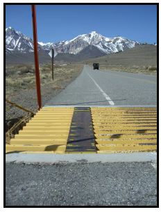
In addition to signage, street features should be planned to accommodate bicyclists. For example, the wider plates on cattle guards on Benton Crossing Road enable bicyclists to cross safely (see Figure 2).
FIGURE 2. Example of Bicycle-friendly Cattle Guard on Benton Crossing Road.
Community Needs
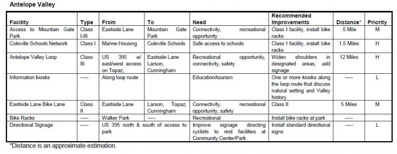
Antelope Valley- Antelope Valley has several small communities spread out along the perimeter of the valley. Bicyclists currently use local highways and roadways to move between those communities and through the valley. These roadways are adequate to serve current and future cyclist demand but safety could be improved by widening the shoulders of the roadways and by striping/signage.
- Antelope Valley is separated from the rest of the county by topography. It does not have any nearby recreational destinations popular with cyclists. Opportunities may exist to promote cycling through the Walker Canyon via the Scenic Byway planning effort.
- The Death Ride is held each year that includes a stretch traveling over Monitor Pass to Hwy 395 and back. There may be an opportunity to coordinate efforts with Alpine County to build upon the success of an event that had 3,500 riders in 2012.
- Swauger Creek/Devil's Gate is an isolated residential area where the provision of bikeways has not been an issue.
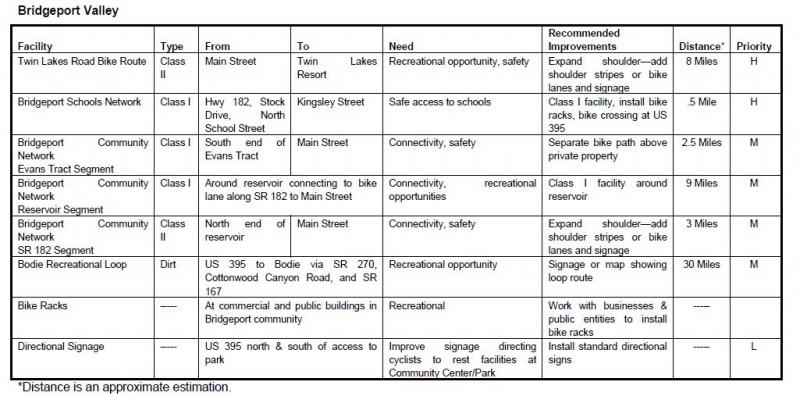
- Bridgeport needs safe commuter routes for children and others from the Evans Tract and the residential areas on SR 182 to the Main Street area and the school. These could be provided by widening the shoulders and designating a bike route or by designating an alternative route.
- Residents have expressed an interest in developing a bike route between Bridgeport and Twin Lakes, a popular cycling route, either by widening the shoulders on Twin Lakes Road or by creating a separate bike path that parallels Twin Lakes Road. Both alternatives, especially the second, might encounter wetlands which would make development difficult. In addition, a separate bike path would require obtaining easements or rights-of-way, which could be expensive and make the project infeasible.
- Residents are also interested in eventually developing a loop trail connecting the Twin Lakes bike trail to Buckeye Canyon Road and linking that segment to a trail around the reservoir.
- The Bridgeport Main Street planning effort developed and implemented Class II bike lanes through the townsite, establishing an opportunity for additional bicycle connectivity to SR 182 and Twin Lakes Road.
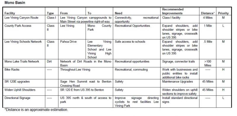
- Mono Basin has a number of dirt roads within the boundaries of the Mono Basin National Forest Scenic Area. Use of those roads is governed by the Comprehensive Management Plan for the Scenic Area, which allows cycling on existing roads.
- US 395 along the west side of Mono Lake does not have adequate shoulders in some areas for safety. Past efforts to expand shoulders were controversial, and the project has since been abandoned by the LTC and Caltrans.
- Major recreational destinations include Mono Lake, the Forest Service Visitor Center, Lundy Canyon, and SR 120/Lee Vining Canyon. Consider connecting these destinations via bike routes.
- Most children at the schools in Lee Vining are bussed to school or walk. Commuting routes for school children are limited.
- Policies in the June Lake Area Plan focus on creating a more inviting and walkable community, and providing alternatives to automobile use. The June Lake Multimodal Plan addressed these concerns, and has since been incorporated directly into the Regional Transportation Plan.
- The main bike route to and through June Lake is SR 158, a narrow, winding route without sufficient shoulders. This is an extremely popular touring route. Safety on this route is a high concern, particularly for cyclists between June Lake Village and the Down Canyon area.
- Public lands surrounding the June Lake Junction, and between June Lake and Mammoth Lakes, contain an extensive system of roads used by mountain bicyclists and off-highway vehicles. There are opportunities to link community bikeways to those roads. In addition, an alternative route parallel to US 395 could be investigated between June Lake and Lee Vining. The USFS continues their effort to highlight routes and eliminate duplicative paths of disturbance.
- Parking facilities for bicycles are limited in June Lake. Additional facilities could be provided in the Village and at the lakes.
- Share-the-road signs along North Shore Drive have been placed to enhance bicycle safety and use, and there is an opportunity to integrate cycling amenities at the Rodeo Grounds/West Village and plan bike paths to access the June Lake Ballfield, parks, and the lakes.
- The western portion of Long Valley is primarily a recreational area. There is no year-round residential development in the area. The area contains an extensive dirt road system, which is mapped in the Interagency OHV Maps. The Inyo National Forest has signed a few roads north of Casa Diablo and north of Mammoth Lakes as bike trails. Maps of those trails are available from the Forest. This is a very popular area with cyclists; additional trail markings may be appropriate.
- There is a potential to connect trails in Mammoth Lakes with trails to the surrounding area by signing existing roads as bike trails.
- The Long Valley area includes the communities of Sunny Slopes/Tom's Place, Aspen Springs, Crowley Lake/Hilton Creek, McGee Creek, and Long Valley. These residential communities have limited commercial activities. Many of the residents work in Mammoth; most of the children go to school in Mammoth.
- Crowley Lake Drive, from Tom's Place to Long Valley, is used for biking by both residents and visitors. The County constructed a bike path along Crowley Lake Drive, from South Landing Road to the Community Library and Park.
- There are a number of recreational areas popular with bicyclists in and adjacent to Long Valley, i.e. Rock Creek Canyon, Owens Gorge Road, Convict Lake Road, and Benton Crossing Road. Rock Creek Canyon and Owens Gorge Road are accessible from the community areas along Crowley Lake Drive. Convict Lake Road and Benton Crossing Road are not accessible except by riding on US 395. Residents are interested in providing alternative routes to US 395. The Interagency OHV Maps show that an alternative route from Crowley Lake to the Convict Lake Road would be possible. An alternative route to Benton Crossing Road would not be possible. Improvements to Rock Creek Road are being completed in 2015, including new pavement surface, bridge rehabilitations, and the addition of a bicycle climbing lane.
- Benton Crossing Road is extremely popular with residents and visitors for cycling. The Circulation Element/RTP contains a policy to designate a bike trail around Crowley Lake on Benton Crossing Road.
- The Circulation Element/RTP also contains a policy to designate a bike trail from Long Valley to Mammoth Lakes. Currently riders must use US 395. A loop from Mammoth Lakes to the Crowley area is another extremely popular cycling route.
- Wheeler Crest and Paradise are somewhat isolated residential areas. The only access road through the area, Lower Rock Creek Road, provides an alternative route to travel on US 395 between Long Valley and Bishop, as well as access to recreational areas along Lower Rock Creek. Lower Rock Creek Road is a narrow, 2-lane road. Residents are interested in providing a bikeway along Lower Rock Creek Road from the Inyo County line to Tom’s Place / Crowley Lake Drive.
- There are limited rest facilities along Lower Rock Creek Road.
- Lower Rock Creek Road is a significant attraction for road bicyclists, and for mountain bikers who utilize the biking/hiking trail adjacent to the road. A staging area is located at the southern end of the trail along the road near the Inyo County line.
Tri-Valley
- Bicyclists utilize SR 120 and SR 6 in the Tri-Valley area (Benton, Hammil, and Chalfant) for touring or long day trips. Increased safety on those roads is a concern.
- Limited rest facilities (restrooms, water) are located at the community parks in Benton and Chalfant. There are no official turnouts along SR 120 and SR 6.
- Chalfant has become a bedroom community for the City of Bishop, approximately 12 miles south in Inyo County. Residents have expressed an interest in developing a bike route between Chalfant and Bishop, either by widening the shoulder of SR 6 or by developing an alternative route. Although many residents of Chalfant commute to Bishop to work, the potential for commuter bicycle use is not high. The distance involved, extreme hot and cold weather conditions throughout the year, and heavy winds do not make commuting by bicycle particularly attractive.
- There is a need for safe bike routes. These could be provided by widening the shoulders and designating a bike route or by designating an alternative route, particularly on Chalfant Road and Valley Road.
- Recreational bicycle use of the Tri-Valley area is limited. There is some interest in developing a bike route to Fish Slough. Another potential bike route is Chalfant Loop Road, connecting Chalfant with White Mountain Estates.
- Oasis is an isolated agricultural area where the provision of bikeways has not been an issue.
Chapter 3: Policies
The following goals, policies and programs provide specific direction for the planning and implementation of bicycle facilities in Mono County. The policies have been developed to be consistent with, and complementary to, policies in the Mono County Circulation Element, the Mono County Regional Transportation Plan, the Inyo County Collaborative Bikeways Plan, and the Town of Mammoth Lakes Mobility Plan.
Countywide System
Goal 1. Develop a cohesive regional and community bikeway system that provides safe and convenient access to all communities and recreational opportunities in Mono County.
Policy 1.A. Maintain a Bikeway Master Plan that identifies existing and future needs, and provides specific recommendations for facilities and programs including adequate provisions for bicycle use to, within, and from Mono County.
Action 1.A.1. Review the Mono County Bicycle Transportation Plan biannually and revise as necessary.
Policy 1.B. Develop a system of community bikeways that connect commercial, recreational and residential areas in communities and that link communities to regional bike routes.
Policy 1.C. Designate regional bike routes that connect communities and that allow for regional travel to, within, and from Mono County.
Policy 1.D. Require all bikeways to conform to design standards contained in the latest version, of the Highway Design Manual, Chapter 1000: Bikeway Planning and Design Caltrans, unless otherwise established by the County.
Policy 1.E. Consider a proposed route's importance in providing access and connectivity to adjacent bikeway facilities and destinations when recommending bike routes for implementation.
Action 1.E.1. Coordinate with the Town of Mammoth Lakes, Inyo County and other governmental entities to ensure consistency with existing and planned bikeway systems.
Policy 1.F. Integrate bicycle planning with other county and community planning, including land use and transportation planning.
Action 1.F.1. Seek opportunities for Federal, State, County and Town joint participation, when appropriate, in the construction and maintenance of bikeways and associated facilities.
Action 1.F.2. Work with community groups and local cycling groups on the development and maintenance of bikeways and associated facilities.
Action 1.F.3. Work with appropriate agencies and organizations to obtain funding for bikeways development.
Commuting
Goal 2. Develop and implement a bikeway system that facilitates commuting to work, businesses, and schools.
Policy 2.A. Develop safe and convenient bikeway routes and facilities for all schools in the county.
Action 2.A.1. Implement the school bicycle routes contained in this plan.
Action 2.A.2. Ensure that funding remains available to maintain bicycle routes on an ongoing basis.
Action 2.A.3. Work with school districts, Caltrans, and the County to develop safe crossings, in order to minimize conflicts between bicyclists and vehicles near school.
Action 2.A.4. Work with school districts to obtain and install safe and convenient bicycle parking facilities at schools.
Action 2.A.5. Continue to implement ongoing safety programs that educate school children in safe bicycle riding.
Action 2.A.6. Pursue Safe Route to School funding for appropriate projects.
Action 2.A.7. Ensure that developers of large-scale projects within commuting distance of a school provide bikeways within the development.
Policy 2.B. Develop safe and convenient bikeway routes and facilities to employment centers throughout the county.
Action 2.B.1. Implement the commuting bicycle routes contained in this plan.
Action 2.B.2. Ensure that funding remains available to maintain bicycle routes on an ongoing basis.
Action 2.B.3. Work with Caltrans and the County to develop safe crossings, in order to minimize conflicts between bicyclists and vehicles in community areas.
Action 2.B.4. Work with local agencies, businesses and community groups to provide additional bicycle parking facilities in community areas.
Action 2.B.5. Work with the County to install safe and convenient bicycle parking facilities at County facilities.
Action 2.B.6. Encourage employers to provide bicycle commuter amenities (secure bicycle storage, changing facilities).
Action 2.B.7. Ensure that developers of large-scale projects provide bikeways connecting to existing local bikeways and/or access to community facilities and services (e.g. employment, shopping and services, recreational areas).
Policy 2.C. Where possible, develop commuting routes as part of multimodal facilities.
Action 2.C.1. Where applicable, develop multi-use routes that serve the needs of multiple users.
Action 2.C.2. Work with the County and local transit providers to install bicycle parking facilities at all bus stops.
Action 2.C.3. Work with local transit providers to ensure that all local and regional busses have bicycle racks.
Action 2.C.4. Consider installing bicycle parking at all airports in the County.
Policy 2.D. Identify community bike routes and commuting routes in order to increase usage and safety.
Action 2.D.1. Work with local agencies, businesses and community groups to develop and distribute maps depicting community bikeways.
Action 2.D.2. Develop and implement a uniform signage program to identify community bikeways and to direct bicyclists to public rest and parking facilities (at community centers, county parks, etc.).
Recreational Use
Goal 3. Develop and implement a bikeway system that supports bicycle-oriented recreation.
Policy 3.A. Support mountain biking opportunities within the Eastern Sierra.
Action 3.A.1. Work with land management agencies to identify mountain biking opportunities on existing roads on public lands.
Action 3.A.2. Develop and implement a uniform signage program to identify mountain biking routes and to direct bicyclists to biking facilities (parking, restrooms, etc.).
Action 3.A.3. Work with Caltrans, the Town of Mammoth Lakes, Inyo County, the Collaborative Planning Team, land management agencies, local biking groups, and other interested entities to develop promotional materials (printed, video, online) that highlight biking opportunities in the Eastern Sierra.
Action 3.A.4. Work with local agencies, businesses and community groups to develop and distribute maps depicting mountain biking routes.
Policy 3.B. Support on-road bicycle touring opportunities within the Eastern Sierra.
Action 3.B.1. Work with local biking groups to identify bicycle touring opportunities within the Eastern Sierra.
Action 3.B.2. Develop and implement a uniform signage program to identify bicycle touring routes and to direct bicyclists to biking facilities (parking, restrooms, etc.).
Action 3.B.3. Work with Caltrans, the Town of Mammoth Lakes, Inyo County, the Collaborative Planning Team, land management agencies, local biking groups, and other interested entities to develop promotional materials (printed, video, online) that highlight biking opportunities in the Eastern Sierra.
Action 3.B.4. Work with local agencies, businesses and community groups to develop and distribute maps depicting touring routes.
Policy 3.C. Support bicycling events in the Eastern Sierra, including organized tours, races, century rides, and similar events.
Action 3.C.1. Work with local biking groups to identify and support organized bike events.
Action 3.C.2. Plan and implement County and Caltrans road maintenance activities in order to provide the best possible experience for on-road events.
Policy 3.D. Provide additional facilities to encourage and promote recreational bicycle use within the Eastern Sierra.
Action 3.D.1. Work with appropriate entities to ensure that the County’s recreational destinations provide facilities for bicyclists, including parking.
Action 3.D.2. Work with land management agencies and the County to develop facilities that provide for touring bicyclists (e.g. campsites with bicycle parking facilities) at existing campgrounds.
Action 3.D.3. Ensure that informational kiosks along highways provide information on bicycle routes in the Eastern Sierra.
System Planning, Design, and Implementation
Goal 4. Implement land use and transportation planning, funding, and design practices that support bicycling.
Policy 4.A. Planning for all types of bicycling shall be a high priority in the existing land use and transportation planning process.
Action 4.A.1. The County’s CIP shall include bicycling improvement projects.
Action 4.A.2. Consider amending the County’s Land Development Regulations to include requirements for the provision of bicycling facilities in new development and redevelopment.
Action 4.A.3. Consider amending the County’s Road Standards to clarify requirements for the provision of bicycling facilities on county roads.
Action 4.A.4. Development or improvement to bikeways, in many cases, will be dependent on roadway improvements. Consult with Caltrans, the Mono County Department of Public Works, and the Forest Service concerning schedules for roadway improvements. Ensure that bikeway needs are considered/included during planning of roadway improvements (rehabilitation, maintenance, widening).
Action 4.A.5. Include bikeway facilities in appropriate local, state, and federal agency development projects.
Action 4.A.6. Development of bikeways on county roads should be consistent with goals and policies for bikeways development and recreational use on adjacent public lands.
Action 4.A.7. Provide input to Federal and State agencies on the development of bike routes on public lands.
Policy 4.B. Design bikeways to provide a safe, efficient, multimodal, well-connected system.
Action 4.B.1. Work with appropriate agencies to develop bikeways and associated facilities that connect to existing trail systems.
Action 4.B.2. When possible, plan and develop bikeways as multi-use year-round facilities.
Action 4.B.3. Where possible, develop bike routes to allow for future connections to an expanded transit system.
Action 4.B.4. Provide developed bikeways and facilities on the most heavily used routes in the County. Maintain the semi-primitive recreational experience in other areas.
Action 4.B.5. Ensure that new and existing bikeways conform to the latest design standards.
Maintenance
Goal 5. Maintain bikeways to provide safe riding conditions.
Policy 5.A. Maintain all bikeways (both on roads and separated bikeways) regularly to provide a safe riding surface.
Action 5.A.1. Sweep roadways as frequently as feasible to keep bicycle travel areas free of debris, including during winter months, as necessary.
Action 5.A.2. Encourage Caltrans to budget for highway maintenance and the maintenance of bicycle facilities, to the highest degree possible.
Action 5.A.3. Ensure that accident debris is removed from the entire roadway, including bicycle lanes, as soon as feasible.
Action 5.A.4. Correct safety concerns on area roadways, such as hazardous rumble strips and inadequate shoulders, through ongoing road maintenance and rehabilitation programs, when feasible.
Action 5.A.5. Maintain bike lane striping and pavement markings, to ensure continued legibility.
Safety Education
Goal 6. Create a safe environment for all bicycle users.
Policy 6.A. Educate bicyclists on how to ride safely.
Action 6.A.1. Work with school districts and the County Office of Education to ensure that all schools provide bicycle safety programs.
Action 6.A.2. Work with local cycling groups to provide safety programs for adults.
Action 6.A.3. Work with local cycling groups to provide safety information for visitors to the area.
Action 6.A.4. Pursue funding opportunities for bicycle safety programs.
Policy 6.B. Educate motorists about sharing the road with bicyclists.
Action 6.B.1. Provide additional share the road signs throughout the County.
Action 6.B.2. Include information about bicycle safety at all informational kiosks along highways.
Policy 6.C. Coordinate bicycle safety efforts among affected local agencies/entities.
Action 6.C.1. Encourage Caltrans District 9 to expand its bicycle webpage and to provide safety information on that webpage, as well as a means of reporting safety and maintenance issues on highways.
Action 6.C.2. Work with Caltrans, the Town of Mammoth Lakes, Inyo County, the Collaborative Planning Team, land management agencies, local biking groups, and other interested entities to develop safety materials (printed, video, online) that specifically address biking opportunities in the Eastern Sierra.
Funding
Goal 7. Ensure that funding is available to develop bikeways and facilities in Mono County.
Policy 7.A. Fiscal analyses for proposed bikeways development projects should consider both construction and maintenance costs.
Policy 7.B. Funding efforts should focus on developing community bikeways and associated facilities. Within communities, focus funding efforts on proposed bikeways where bicyclist demand is highest, safety concerns are greatest, and where roadway improvements will not necessarily improve biking conditions.
Policy 7.C. Countywide funding priorities for bikeways development should be established in the Capital Improvement Program (CIP) for Mono County.
Action 7.C.1. The County shall include applicable bikeways development projects identified in this Plan in its Capital Improvement Program (CIP).
Policy 7.D. Pursue all funding options for bicycle facility construction and maintenance.
Action 7.D.1. Utilize the CIP to identify proposed projects for applicable bicycle funding sources, such as the California Bicycle Transportation Account (BTA).
Action 7.D.2. Pursue funding from the BTA and Safe Schools Program to complete identified priority projects.
Action 7.D.3. Include proposed bikeways in roadway improvement projects whenever possible.
Action 7.D.4. Use existing funding as matching funds for state and federal funding.
Policy 7.E. Develop a strategic plan in consultation with Federal, State, and local agencies for coordinating and applying for bikeways funding.
Action 7.E.1. Prepare joint applications for bikeways projects, whenever possible.
Policy 7.F. Revise funding priorities annually, to reflect changes in funding availability and local and regional needs.
Action 7.F.1. Update funding information annually, including available programs for bikeway facilities, specific funding requirements, and deadlines.
Community Policies
Community Policies for Bikeways Development
Community policies were not developed for areas with little or no bicycle use and no identified issues (i.e. Swauger Creek/Devil's Gate and Oasis), or for areas with primarily regional routes (Mammoth Vicinity/Upper Owens, Wheeler Crest/Paradise).
Goal 8. Support bicycling safety, connectivity and facilities based on the needs in individual communities.
Antelope ValleyPolicy 8.A. Develop a loop bikeway route in the Antelope Valley by widening the shoulders on designated portions of US 395, Topaz Lane, Cunningham Lane, Larson Lane, and Eastside Lane.
Policy 8.B. Develop one or more informational kiosks along the loop route that discuss the Valley's history and natural setting.
Bridgeport ValleyPolicy 8.C. Develop a bikeway along SR 182 from the reservoir to town and along US 395 from the Evans Tract to town.
Policy 8.D. Develop a bike route from Bridgeport to Twin Lakes by widening the shoulder along Twin Lakes Road.
Policy 8.E. Provide interpretive signing in the Bridgeport Valley that discusses the Valley's ranching history, natural setting, and how to avoid potential user conflicts and resource damage.
Policy 8.F. Work with the Forest Service to develop a signed bike route along Timber Harvest Road and Reservoir Road.
Policy 8.G. Provide additional signage in Bridgeport directing cyclists to rest facilities at the park.
Policy 8.H. Provide increased recreation opportunities for mountain biking enthusiasts.
Policy 8.I. For trails connecting residential and recreational areas, consider multi-use trails capable of accommodating many modes of transportation.
Mono BasinPolicy 8.J. Work with Caltrans to develop a safe bike route on US 395 along the west side of Mono Lake from Lee Vining to the County park.
Policy 8.K. Work with appropriate agencies to develop a bike trail from Lee Vining to the campgrounds in Lee Vining Canyon, utilizing existing roads where possible.
Policy 8.L. Continue community conversations to consider a bike trail connecting Mono City to Lundy Canyon which, in concert with Policies 8.J. and 8.K., connect Lundy Canyon to the County park, Mono City, Lee Vining, and Lee Vining Canyon.
Policy 8.M. Work with community groups and businesses to provide additional bike racks in Lee Vining.
Policy 8.N. Provide signage in Lee Vining to direct cyclists to rest facilities at the park.
June Lake LoopPolicy 8.O. Develop bike routes in June Lake in conformance with the June Lake policies in the Regional Transportation Plan.
Policy 8.P. Link the bike routes in June Lake to popular recreational areas surrounding the June Lake Loop.
Policy 8.Q. Work with community groups and businesses to provide additional bike racks in the June Lake Village, at the marinas, and at the parks.
Long Valley
Policy 8.R. Provide community bike paths in Crowley Lake as follows:
- Widen shoulders along Crowley Lake Drive from Tom's Place to Long Valley, to provide for bicycle safety (tie to resurfacing of Crowley Lake Drive);
(Note: Sections of this route should be prioritized)
- Widen shoulders along South Landing Road, from Crowley Lake Drive to Crowley Lake, to provide for bicycle safety (this requires acquiring the right-of-way from Lakeview Subdivision north);
Policy 8.S. Work with Caltrans and the Forest Service to develop and implement standardized signing for bike routes on Sherwin Creek Road, Owens Gorge Road, and Substation Road.
Policy 8.T. Work with community groups and businesses to provide bike racks at appropriate places in Crowley Lake.
Wheeler Crest/ParadisePolicy 8.U. Provide a bikeway along Lower Rock Creek Road (e.g. bicycle climbing lane from the Inyo County line to Tom’s Place/Crowley Lake Drive)
Policy 8.V. Work with community members prior to the development of new trail planning efforts.
Policy 8.W. Work with the community, user groups and the BLM to maintain and improve Lower Rock Creek Trail (e.g. volunteer work days, wayfinding, etiquette and/or additional user facilities).
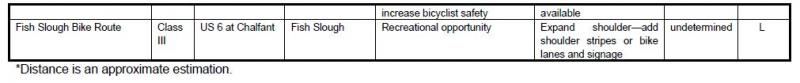
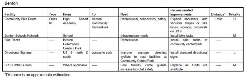
Tri-ValleyPolicy 8.X. Work with the Forest Service to develop a bike route to Fish Slough and to provide interpretive signing at Fish Slough.
Policy 8.Y. Improve signage directing cyclists to rest facilities at parks in Benton and Chalfant.
Chapter 4: Demand for Bicycle Facilities
Current and future demand for bicycle facilities in Mono County is difficult to measure or project since the County has no data on bicycle trips other than the extremely limited data from the 2000 Census. The 2010 Census does not provide any information on estimated number of bicycle trips in Mono County. The following sections analyze existing and future bicycle demand in relationship to the County’s overall goal of developing a cohesive regional and community bikeway system for Mono County.
Land Use Patterns
A general pattern of development recurs throughout the County. Development is concentrated in small communities located along US 395 or SR 6 (with the exception of Wheeler Crest and Paradise); recreational uses are dispersed throughout the county. Most of the limited amount of private land in the county is located in community areas. Public lands (94 percent of the land in the county) generally remain as open space and are used for a variety of recreational uses, including biking.
Most of the development in the county is low density; the most intense development occurs in the Town of Mammoth Lakes. Communities generally have a small commercial area surrounded by low-density residential development. Some communities (June Lake, Lee Vining, Bridgeport, Crowley Lake) have limited numbers of multiple family housing units mixed in with their commercial uses.
The Town of Mammoth Lakes is the major activity center in the county. Most of the services available in the county are provided there, along with the majority of shopping opportunities. Limited services, including schools, are available in some communities in the unincorporated area, primarily in Bridgeport where government offices are located. Several recreational destinations, such as Mono Lake and Bodie State Historic Park, have visitor centers and a definite center of activity. Many of the county’s other recreational destinations are dispersed with no defined activity center.
Bicycle Demand
Demand for bicycle facilities in Mono County falls into four categories:
- Bicycle routes for residents and visitors for alternate transportation and commuting between camping areas, day use areas, commercial areas, and businesses and employment.
- Bicycle routes for residents and visitors to Mono County for recreational use, sightseeing, and exercise.
- Safe bicycle routes in each community for children commuting to and from school and other activities.
- Safe bicycle routes for long distance riders on state and local highways and roadways.
There is currently limited demand by residents for commuting routes; this is unlikely to change. Land use patterns in the County have created a situation where it is not practical for most people to commute to work on bicycles or for many students to commute to school using bicycles. Both students and workers must often drive many miles to their destination, to a community other than the one in which they reside. Extreme weather conditions also make it difficult to bicycle year-round; snow and ice in many parts of the county eliminate winter biking opportunities, while extreme heat and dust storms decrease summer biking opportunities in other areas. Depending on the destination, safety considerations may eliminate the possibility of biking within communities. Many access routes in communities are either along highways or cross highways, often without adequate shoulders.
Increasing safety within communities and between communities and providing connections between Mammoth Lakes and surrounding communities would increase bicycling opportunities and demand.
Recreational use continues to increase. There is a need for a variety of recreational biking opportunities, ranging from short paved paths appropriate for family biking experiences, to long distance touring routes, and off-road experiences. When designating bike routes, it is important to remember that recreational users are looking for that variety.
Population Projections
Mono County’s population in 2007 was estimated to be 14,625 persons; 8,275 persons (60 percent) in Mammoth Lakes and 6,250 persons (40 percent) in the unincorporated portion of the county (see Table 1). The percentage of the overall population that lives in Mammoth Lakes has increased slightly since 2000.
TABLE 2. Mono County Population Estimates, 2015

Table 2 shows population projections for the county for the next 25 years. It includes the percent of the population over the age of 15 as an indicator of the number of people who may be commuting and the percent of the population aged 15-69 as an indicator of the number of people most likely to be commuting. Over the next 25 years, the percentage of the population older than 15 is expected to remain stable at 84 percent while the percentage of the population aged 15-69 is expected to decrease slightly as the population ages.
TABLE 3. Mono County Population Projections, 2020-2040
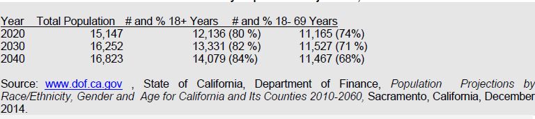
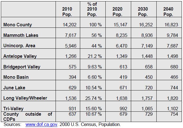
Table 3 shows population projections by community areas through the year 2040. The community projections are based on the following assumptions: that the unincorporated area will continue to house approximately 43 percent of the total countywide population and that the population distribution in the unincorporated community areas will remain similar to the population distribution in 2010. The last assumption may not hold true. Antelope Valley is experiencing increasing development pressures from the Gardnerville/Carson City area; Chalfant is experiencing a similar pressure for expansion from the Bishop area; and Benton, Chalfant, and the Long Valley communities are experiencing continuing pressure from residents who work in Mammoth. As housing prices continue to rise in Mammoth Lakes, other areas of the county may experience increasing development pressure.
It is important to note that the population projections shown in Table 3 are for permanent year-round residents. Mono County, and particularly community areas such as Mammoth Lakes and June Lake, experiences much higher peak populations during periods of heavy recreational use, a factor that has a direct impact on the transportation system. Projected peak populations are utilized to determine transportation/travel demand in Mammoth Lakes and June Lake.
TABLE 4. Mono County Community Population Projections, 2010-2040
Land Use Forecasts
Development in Mono County communities is primarily residential with limited small-scale commercial uses serving local and tourist/recreational needs. Limited small-scale light industrial uses, such as heavy equipment storage and road yards, also occur in some county communities. Most communities also have public facilities such as schools, libraries, community centers, parks and ballfields, and government offices (in Bridgeport). This development pattern is not anticipated to change, due to the small scale of communities in Mono County, the limited private land base for expansion, and the lack of employment opportunities in most communities.
The Land Use Element of the County's General Plan contains policies that focus future growth in and adjacent to existing communities. Substantial additional development outside of existing communities is limited by environmental constraints, the lack of large parcels of privately owned land, and the cost of providing infrastructure and services in isolated areas. Land use policies for community areas in the county (developed by the county’s citizens regional planning advisory committees) focus on sustaining the livability and economic vitality of community areas. The General Plan anticipates that growth in the unincorporated area will occur primarily in the Antelope Valley, Bridgeport Valley, June Lake, Wheeler Crest/Paradise, the Tri-Valley, and Long Valley.
Employment
Mono County's economy is dominated by services, retail trade and government. Industry projections from the California Employment Development Department for the Eastern Sierra Region estimate that job growth in the area between 2004 and 2014 will be strongest in Leisure and Hospitality Services, Government, Retail Trade, and Trade, Transportation and Utilities. Major job centers are located in Mammoth Lakes (services, retail trade, government), June Lake (seasonal services and retail trade) and Bridgeport (government). Despite the availability of Commercial (C) and Mixed Use (MU) zoning throughout communities in the unincorporated area, it is unlikely that sufficient jobs will develop to eliminate the need for workers to commute to jobs outside their communities.
Employment trends for the unincorporated area vary from the County as a whole, with higher percentages in agriculture, construction and mining (particularly mining), manufacturing, transportation and public utilities, and services, and lower percentages in wholesale trade, retail trade, finance, insurance, real estate, and government.
Employment data for September, 2009, from the Employment Development Department show the following current employment by industry (not seasonally adjusted):
Total Wage and Salary 6,280
Leisure and Hospitality 2,870
Government 1,650
Trade, Transportation and Utilities 600
Retail Trade 490
Goods Producing 390
Financial Activities 260
Professional and Business Services 240
Transportation, Warehousing and Utilities 100
Educational and Health Services 40
Manufacturing 40
Farm 20
Wholesale Trade 10
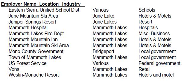
The following list of major employers in Mono County was developed using the 2009 America's Labor Market Information System Employer Database (California Employment Development Department, www.labormarketinfo.edd.ca.gov). Many of these employers are located in Mammoth Lakes, a significant commute from many areas of the County.
Place of Work
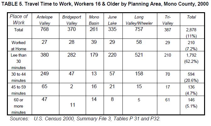
The 2009-2013 American Community Survey 5-year Estimate[1] indicated 99% of workers 16 years and older residing in unincorporated Mono County worked within the state and 91% worked within Mono County. These numbers indicate a significant increase in the jobs/housing balance over 2000, when only 75% worked in the state and county (US Census 2000, Summary File 3, Tables P 31 and P32). The mean travel time to work also decreased from less than 30 minutes in 2000 to just over 16 minutes in the 2009-2013 estimate. The primary means of transportation to work was a car, truck or van (67%). Of these, 54% were single-occupancy vehicles and 13% were carpools with two or more persons. Walking accounted for 14% of commuters, followed by public transportation (5%), bicycling (2.5%), and taxicab/motorcycle/other (2%). Workers from home constituted 10%.
The most recent data on travel times from communities to work locations is from the 2000 Census. The 2010 Census does not appear to provide this information. In 2000, travel times to work were highest in Antelope Valley and Tri-Valley, reflecting the fact that many residents of those areas work outside the community. A large number of Long Valley/Wheeler Crest workers commuted between 30 and 44 minutes, probably to Bishop or other points in Inyo County (see Table 4).
Future Demand
Future demand for bicycle facilities in Mono County is difficult to project since the County has no data on bicycle trips other than the extremely limited data from the 2000 Census. Data from the 2000 US Census show that only 3 out of 2,878 daily trips in the unincorporated area were made via bicycle (2000 US Census, SF3, P30), less than one percent of the total. In 2000, 298 daily trips to work were made by walking, approximately 10 percent of the total trips. The 2010 Census does not provide estimates on bicycle trips.
Many Mono County communities are small enough to allow commuting by bicycle. However, as discussed previously, many County residents do not work in the community in which they live. This is unlikely to change, since most communities are primarily residential with limited employment opportunities. Commuting between communities is difficult due to the distances involved, the terrain, and unfavorable weather conditions much of the year.
Enhancements to bicycle facilities within communities could increase the use of bicycles for commuting and trips to school. The development of additional bicycle facilities between community areas could increase commuting between certain communities when the weather is favorable.
Future demand for recreational bicycle use throughout the County is expected to continue. The development of additional bicycle facilities intended for recreational users and the continued enhancement of County roads and highways to provide an optimum experience for recreational users is expected to increase recreational cycling.
Chapter 5: Proposed Bikeway System
This chapter contains descriptions and maps of existing and proposed bicycle facilities and programs in Mono County. The criteria utilized to develop and prioritize the projects for the bicycle system are based on the information in prior chapters in this plan, i.e. Chapter 2: Needs Assessment, Chapter 3: Policies, and Chapter 4: Demand for Bicycle Facilities. As projects are more fully scoped and developed, adequate environmental documentation will also be developed to meet California Environmental Quality Act requirements.
Bicycle System Selection Criteria
The overall goal of this Plan is to “develop a cohesive regional and community bikeway system that provides safe and convenient access to all communities and recreational opportunities in Mono County.” In order to achieve this goal, the following criteria were utilized to develop the proposed bikeway system for the unincorporated areas of Mono County:
- The routes use existing roads and facilities where possible in order to provide the most cost effective bicycle system. New routes/facilities are considered when safety and convenience would be maximized by developing such routes and when the development of such routes would increase bicycle use.
- Proposed routes connect residential areas, schools, commercial areas, and local parks in order to develop community bicycle routes.
- The routes provide continuity with bicycle routes and trails in surrounding communities and counties, providing access to recreational destinations, in order to develop regional bicycle routes.
- The routes maximize multimodal connections within the County and to and from the County.
- Proposed bicycle routes and facilities maximize safety.
- Support facilities are included in the development of the system in order to maximize safety and convenience and to encourage additional use of the system.
- Educational/promotional programs are included in the development of the system in order to maximize safety and to encourage additional use of the system.
Proposed Bicycle Routes
Bike routes identified in this plan provide for:
- The commuting needs of employees, businesspersons, shoppers and students;
- Connection of community areas to local and regional recreational areas and existing trail systems;
- The needs of recreational bicyclists;
- Parking and rest facilities; and
- Multiple use of facilities where possible.
Popular touring routes traversing the entire county are included along with local routes focused in communities. Maps identifying both the regional routes and the community routes are shown on the following pages.
Proposed Support Facilities
- Parking. Secure, convenient bike parking is a key component of a bicycle system and a cost effective way to encourage additional use of the system. The County currently has very few bike racks. Policies in this plan require the County to work with applicable agencies to get bike racks installed at schools, within communities, and at recreational destinations.
- Storage and Changing Facilities. Due to the relatively low volumes of commuters in the County, facilities for storing clothing and equipment and for changing are not a priority. This need will continue to be met by employers in the near future.
- Multimodal Facilities. Multimodal facilities may include bike racks at bus stops and trailheads, bike racks on buses, and bike racks at airports. Due to the distances between communities in the County, use of several forms of transportation may prove more feasible than biking alone. The availability of safe, convenient bike racks could encourage additional use of other forms of transportation.
- Signage. Since many of the bicycle routes within the County are on county roads or state highways, clear signage is critical. Policies in this plan require the development and implementation of a uniform sign program throughout the County, and the installation of additional share the road signs.
- Lighting. Lighting, particularly adjacent to bicycle parking facilities, may enhance the safety of the system. Lighting in Mono County communities should minimize glare on adjacent properties. Streetlights in Mono County communities are generally sufficient for on-street bike routes.
Education and Safety Programs
- Safety Education Programs. Limited bicycle safety programs are available in the County; those programs focus on school children. Since many of the bike routes within the County are on-street routes and many are located along rural highways with unique safety issues, additional safety programs geared towards visitors and touring cyclists would increase safety.
- Signage. As discussed above, additional signage, particularly in areas where bicyclists must share the road with motorists, will increase safety for all.
- Maps. Maps, videos, and websites with information on local and regional bike routes could increase bicycle use by showing riders potential routes and connections to services and facilities. Limited maps are currently available on various websites, including Caltrans District 9’s bike page. A comprehensive, regional map showing both on- and off-street routes, connections to communities and recreational destinations, and facilities would highlight the importance of bicycling in the Eastern Sierra.
Potential Projects
The following potential projects are based on the needs identified by local cycling groups and on recommended projects developed by community members in consultation with staff. Some of these projects are included in the County’s existing General Bikeway Plan, others are newly developed.
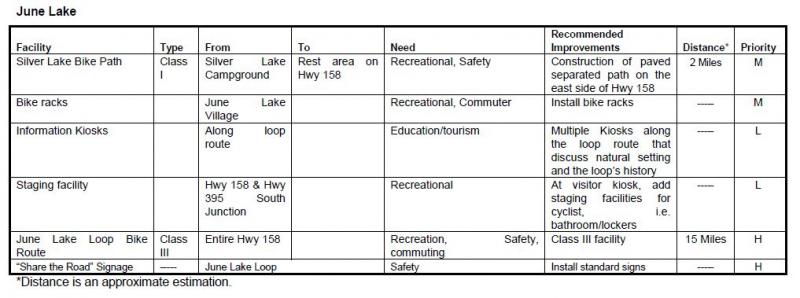
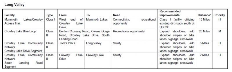
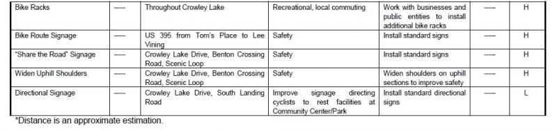
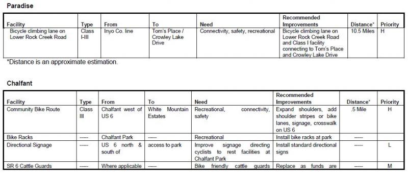
TABLE 6. Potential Projects
Chapter 6: Funding, Implementation, and Phasing
Estimated Project Costs
The Inyo County 2007/2008 Collaborative Bikeways Plan contains estimated costs for developing different types of bikeways. Those estimates will be utilized in this plan since development conditions are similar in the two counties. Some facilities may also be developed as regional facilities that are located in more than one county.
The Inyo County 2007/2008 Collaborative Bikeways Plan notes that:
These cost estimates are based on costs experienced in other California communities, recent cost estimates developed as part of traffic impact fee and mitigation analysis, and previous bikeway planning projects in the County of Yuba, City of Roseville, and City of Oakdale. The cost estimates include engineering, permitting, right-of-way, construction and inspection costs. These cost estimates should be used only to develop generalized construction cost estimates and project prioritization. More detailed estimates can be developed after preliminary engineering and design.
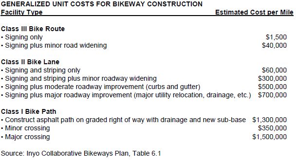
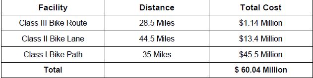
The unit costs identified in the above table have been applied to the proposed bikeway system. A summary of total system costs by facility type is presented in the table below.
Funding Sources
Funding for bikeways and associated facilities is available from a number of federal and state programs. This section summarizes each of those sources. Generally, the local jurisdiction is responsible for applying for the funding identified below. Cooperative efforts among local agencies, such as the Forest Service, the County, and other local entities have been successful in obtaining funding for Mono County projects. It is important to note that many of these programs provide funding for the construction of bicycle facilities but not for on-going maintenance.
Federal Sources
Regional Surface Transportation Program (RSTP) – LTC, Caltrans
Provides funds for transportation projects on systems funded by federal-aid (functionally classified higher than local road or rural minor collector). Funds are available for bicycle and pedestrian facilities, transportation enhancement activities, and parking facilities (commuting and recreational programs).
Federal Safe Routes to Schools – Caltrans
For projects that connect schools and provide safe access for students (safety/education projects).
Recreational Trails Program – California Department of Parks & Recreation
For recreational trails to benefit bicyclists, pedestrians, and other users (recreational projects).
Transportation and Community and System Preservation Pilot Program – Federal Highway Administration
For projects that improve system efficiency and reduce the environmental impacts of transportation (commuting projects).
Land and Water Conservation Fund – California Dept. of Parks & Recreation
Projects that acquire and develop outdoor recreation areas and facilities (recreation projects).
State Sources
Safe Routes to School (SB 10) -- Caltrans
Provides funds for commuting, recreational use, and safety/education. Primarily intended for construction projects to enhance safety of pedestrian and bicycle facilities (commuting, recreation, safety/education projects).
Bicycle Transportation Account (BTA) -- Caltrans
Local jurisdictions must have a "Bicycle Transportation Plan" approved by CalTrans to submit applications. Project must conform to requirements of Caltrans Highway Design Manual, Chapter 1000. Intended for projects that improve the safety and convenience of bicycle commuters (commuting, safety/education projects).
Regional Transportation Improvement Program (RTIP) -- LTC
The local component of the State Transportation Improvement Program (STIP), the main transportation project funding source in the state. Projects must improve transportation within the region (commuting, safety/education projects).
Community Based Transportation Planning Demonstration Grant Program – Caltrans
For projects that exemplify livable community concepts (commuting projects).
Office of Traffic Safety Grants – Caltrans
May provide funds for bicycle and pedestrian projects (safety/education projects).
Active Transportation Program (ATP) – LTC, Caltrans
The ATP consolidates existing federal and state transportation programs, including the Transportation Alternatives Program (TAP), Bicycle Transportation Account (BTA), and State Safe Routes to School (SR2S), into a single program with a focus to make California a national leader in active transportation.
Other Sources
Funding may also be available from local agencies and private organizations. Recent cooperation between the U.S. Forest Service and the community of Lee Vining resulted in the construction of the Lee Vining community trail, and a local snowmobile enthusiasts groups have helped develop signed snowmobile trails on public lands.
In addition, it may be possible to obtain assistance from local groups and businesses in the construction and maintenance of bikeway facilities through a sponsorship program similar to the Adopt-A-Highway program implemented by Caltrans. For construction projects, assistance could be cash or the donation of goods and/or services; for maintenance activities, assistance may come from the donation of goods and/or services.
Appendix A: References
References Consulted
Bureau of Land Management (BLM)
Resource Management Plan for the Bishop Resource Area. 1991.
California Department of Transportation (Caltrans)
Highway Design Manual, Chapter 1000, Bikeway Planning and Design, 1/4/07.
Transportation Funding in California. 2007.
California Employment Development Department (EDD), Labor Market Information Division (LMID)
Mono County Profile. 2009.
Fehr and Peers, Transportation Consultants
Inyo County Collaborative Bikeways Plan. 2008.
Mono County Local Transportation Commission (LTC)
Mono County Regional Transportation Plan (RTP). 2008.
Mono County Planning Division
Mono County General Plan. 1993.
Mono County General Plan, Revised Land Use Element and Land Development Regulations. 2001.
Mono County Housing Element Update. 2009.
Mono County Master Environmental Assessment. 2001.
Mono County Trails Plan. 1994.
U.S. Forest Service (USFS)
Inyo National Forest Land and Resource Management Plan. 1988
Internet Reference Sites
The current internet address at the time of printing is listed for these sources; the address may have since changed.
California Department of Transportation (Caltrans)
Eastern Sierra Bicycle Guide, other Caltrans transportation planning documents.
California Department of Finance (DOF)
Demographic Research Unit, population and socio-economic statistics and forecasts, California Statistical Abstract.
Eastern Sierra Transit Authority (ESTA)
Information on transit services in the Eastern Sierra.
www.easternsierratransitauthority.com
Eastside Velo
Information on cycling in the Eastern Sierra.
Employment Development Department (EDD)
Labor market information, socioeconomic data, income and poverty statistics (Countywide level), occupational employment statistics.
www.labormarketinfo.edd.ca.gov
Sierra Cycling Foundation
Information on cycling in the Eastern Sierra.
www.sierracyclingfoundation.org
Town of Mammoth Lakes
Programs and policies in Mammoth Lakes.
U.S. Census Bureau
Population, housing, economic and social data from the 2000 Census, 5-year Economic Census, and other studies.
Utu Utu Gwaitu Paiute Tribe (Benton Paiute Reservation)
Information on tribal programs
www.bentonpaiutereservation.com
Appendix C: Maps
| Figure | Location/Area | Page |
| 3 | Antelope Valley | p54 |
| 4 | Bridgeport Valley/Twin Lakes | p55 |
| 5 | Bridgeport Community | p56 |
| 6 | Lee Vining Community | p57 |
| 7 | June Lake Loop | p58 |
| 8 | Long Valley | p59 |
| 9 | Benton Community | p60 |
FIGURE 3. Antelope Valley Bike Facilities Map
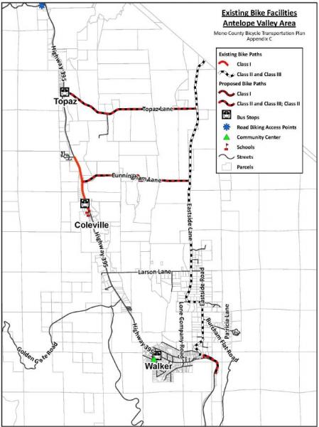
FIGURE 4. Bridgeport Valley/Twin Lakes Bike Facilities Map
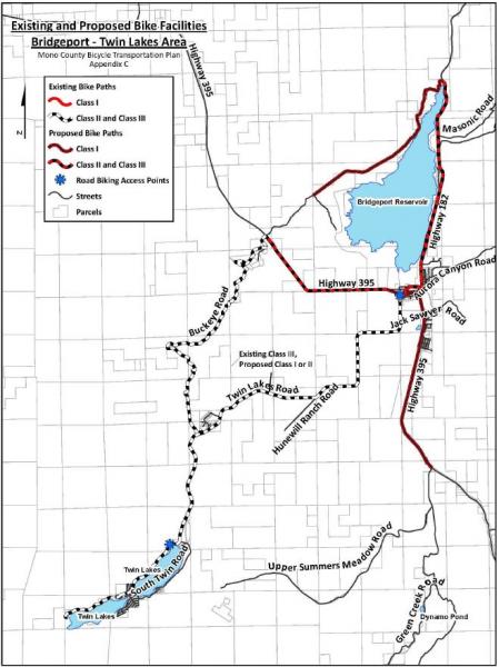
FIGURE 5. Bridgeport Community Bike Facilities Map
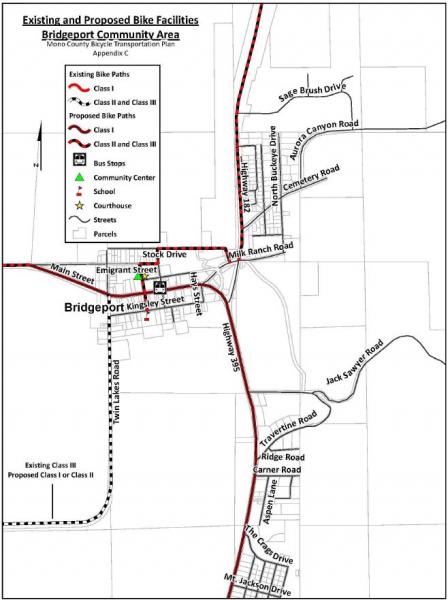
FIGURE 6. Lee Vining Community Bike Facilities Map
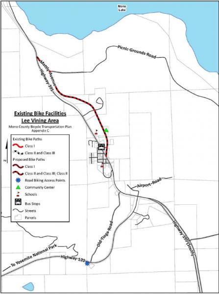
FIGURE 7. June Lake Loop Bike Facilities Map
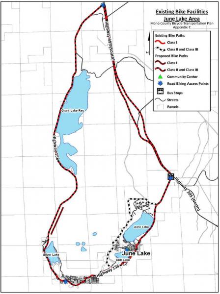
FIGURE 8. Long Valley Bike Facilities Map
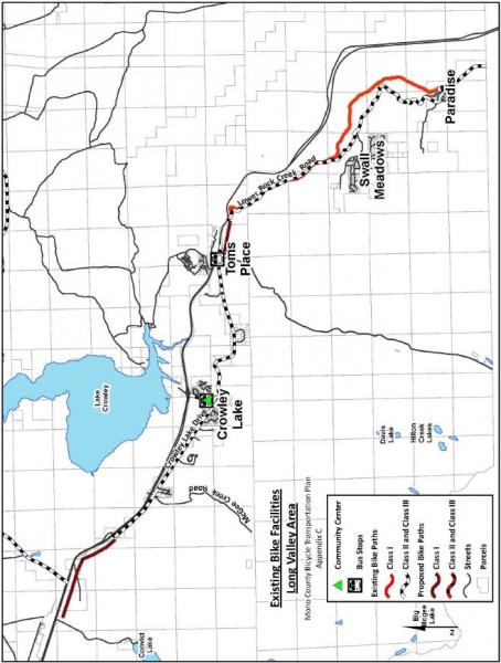
FIGURE 9. Benton Community Bike Facilities Map
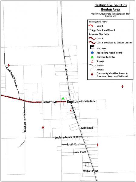
[1]Via searches on the American Fact Finder (U.S. Census website) at http://factfinder.census.gov/faces/nav/jsf/pages/index.xhtml and at http://factfinder.census.gov/faces/tableservices/jsf/pages/productview.x...