General Plan
Government Code § 65300 requires each county to "adopt a comprehensive long-term general plan for the physical development of the county." Mono County is unique in that the General Plan and Zoning Code have been combined into one document.
The purpose of the Mono County General Plan is to establish policies to guide decisions on future growth, development, and conservation of natural resources in the unincorporated area of the county. The plan reflects community-based planning and includes individual area plans for Mono County communities.
The following summarizes the vision of the Mono County General Plan:
The environmental and economic integrity of Mono County shall be maintained and enhanced through orderly growth, minimizing land use conflicts, supporting local tourist and agricultural based economies, and protecting the scenic, recreational, cultural, and natural resources of the area. The small-town atmosphere, rural- residential character and associated quality of life will be sustained consistent with community plans. Mono County will collaborate with applicable federal, state and local entities in pursuing this vision through citizen-based planning and efficient, coordinated permit processing.
The planning areas of June Lake and Mono Basin also have separately published area or community plans, which are incorporated into the Land Use Element of the General Plan. These documents will be posted below when they are available.
The work upon which this publication is based was funded in part through a grant awarded by the California Strategic Growth Council. Disclaimer: The statements and conclusions of this report are those of Mono County and not necessarily those of the California Strategic Growth Council or of the California Department of Conservation, or its employees. The California Strategic Growth Council and the California Department of Conservation make no warranties, express or implied, and assume no liability for the information contained in the succeeding text.
03-01 Introduction
The Circulation Element is intended to serve as an infrastructure plan addressing communications, County facilities, community services infrastructure, and the movement of people and goods. The Regional Transportation Plan (RTP), developed through a coordinated effort with Caltrans and including the municipal jurisdiction of the Town of Mammoth Lakes, is utilized in its entirety to address the movement of people and goods. Policies relating to energy, water, sewage, and storm drainage infrastructure are contained in the Conservation/Open Space Element.
The communications policies are intended to provide information, guidance, and recommendations as they relate to the development, implementation, and accessibility of communications infrastructure, particularly basic telephone, wireless telephone, and broadband Internet. These policies draw from a number of technical resources, reports, and other jurisdictions, including but not limited to the Humboldt County General Plan, policy work developed by the City of Santa Cruz, the Eastern Sierra Innovation and Prosperity Report developed by Sierra Business Council, and the Mono County Economic Development Strategy.
The County facilities policies are intended to provide structure for the cataloging and selection of projects relating to County facilities. Policies to reduce energy consumption in County facilities are located in the Conservation/Open Space Element. The community infrastructure policies are intended to describe the mechanisms that ensure adequate services within community areas.
By statute, the Circulation Element must correlate directly with the Land Use Element, and has direct relationships with the Housing, Open Space, Noise, and Safety elements.
Land Use: The Regional Transportation Plan (RTP) considers and incorporates demographic and land use projections, correlating transportation issues directly with the Land Use Element. In addition, communication policies directly correlate with development standards in the Land Use Element.
Housing: In Mono County, the circulation system is well established, and there is little traffic congestion. When congestion does occur, it is not the result of residents’ commuting, but of recreational traffic at peak use periods or special events, combined with local use. The existing circulation system is generally adequate to provide for additional housing, and the RTP provides for improvements to the local transportation system that will allow for the continued development of housing.
Conservation/Open Space: Since 94% of the land in Mono County is publicly owned, and 90% is federally owned, much of Mono County remains open space. Policies in both the Conservation/Open Space Element and the Land Use Element focus future development in existing community areas, providing additional open-space protection. The RTP focuses on transportation issues within and connecting these existing community areas, and communications and facilities/infrastructure policies focus on serving these existing communities. The communications policies and related regulations in the Land Use Element are sensitive to the potential impacts of communication infrastructure on the open-space character of the county.
Noise: The transportation network is the primary source of noise within Mono County, and the Noise Element quantifies noise exposure of the transportation routes identified in the RTP.
Safety: The Safety Element recognizes the potential impacts of seismic, geologic, flooding, avalanche, and fire hazards to the transportation network and existing communities. In addition, the RTP and communication policies in the Circulation Element address lack of cell phone coverage along transportation corridors as safety needs of traveling motorists.
03-02 Issues/ Opportunities/ Constraints
- Telecommunications infrastructure and services are critical components for long-term growth and sustainability for the county, as they provide the basic resources necessary for businesses to operate and add to the quality of life for residents. Increasingly, business success is tied to online accessibility, including e-commerce solutions, discoverability, and the overall necessity of high-quality broadband capable of high speeds with symmetric up and down transfer rates. Of equal importance is broadband to residents for access to online education, research, employment, health care, and government resources.
- Historically, Mono County has suffered from a lack of quality broadband due to our rural nature and low population with dispersed community areas. With the installation of Digital 395 (see III.C. Definitions for more information) in 2013, however, capacity issues will be resolved and new opportunities will arise.
- With the rapid advances in mobile device technology, both providers and subscribers are increasingly looking to mobile solutions to help fill communication gaps and provide alternatives to typical fixed deployments. While the mobile alternatives are extremely valuable at fulfilling their role, they are not a panacea for solving broadband issues throughout the county.
- The primary issues with the mobile broadband solution are the data caps that are placed on customers, the overall cost of the service, and the typical requirement of a long-term contract in order to receive the service. While these are hurdles typically overcome by those looking to utilize this technology as a secondary method for accessing the Internet, for those who are looking at it as their primary, they may be insurmountable.
- For the most part, some form of cellular coverage exists in almost every community; however, it is carrier dependent. AT&T and Verizon are the two main carriers, whose coverage models overlap, but do not provide the same coverage in all of the same areas. In addition to some communities not having cellular service, there are significant sections of our primary highway corridors without coverage, which poses safety concerns and convenience issues for travelers.
- With Digital 395, cellular coverage throughout the county may improve as new sites are developed and existing sites improved with upgraded technology that adopts a fiber-fed backhaul. This development pattern is important, and should be considered strategically and implemented thoughtfully in order to meet goals and objectives while adhering to policies and parameters.
- Within the context of non-mobile broadband technology, Mono County continues to struggle with the basic aspects of accessibility, reliability, and adoption. These three aspects are closely related to each other, as the region as a whole has been starved of quality Internet until very recently. Where service is accessible (mainly in the major community areas), the reliability and usability of that service has not always been great enough to motivate everyone to adopt. Coupled with the demographics of the region (a mix of income levels, education, age, and ethnicities), a portion of the population still does not use the Internet.
- Outside the town of Mammoth Lakes and the community of June Lake, most communities do not have more than one Internet Service Provider. For the most part, smaller communities are serviced by a single, fixed wireless provider (Schat.net), leaving only one other small, wireline provider (Escape Broadband) to compete with the bigger companies offering wireline service – Suddenlink and Verizon.
- Due to limited competition, the market in each community has been dominated by a single (non-mobile) carrier, which limits consumer choice, stifles competition, and does not afford redundancy. In addition, business use of Internet is limited to residential- grade service plans, with only a small number of T1 type connections, or similar higher- speed service offerings. In general, this has not only resulted in those businesses being confined to Mammoth or June Lake, but also made it difficult or financially impractical for businesses to get higher speeds or symmetric service offerings.
- A high priority is placed on broadband market development, and the engagement of Mono County in the regional deployment of this critical infrastructure. Participation in local, regional, statewide, and federal efforts that are aimed at the improved diffusion of broadband and communications technology is an important part of achieving the goals and objectives.
- County facilities provide important public gathering spaces and focal points in local communities. Determining the highest priority community facilities is often a challenging public conversation.
- County facilities provide important office space for employees to serve the public and are critical to work-space quality. Care and consideration should be given to facility purpose, work-space planning, special requirements, etc. when designing and building.
- The operations and maintenance of facilities and infrastructure, both ongoing and ever-increasing costs, are a challenge and should be considered in the planning and financing for capital improvements.
- Adherence to a standardized procedure for submitting, reviewing, approving and implementing facilities projects is needed to ensure limited resources are utilized effectively.
- Due to the size, isolation and dispersed nature of Mono County and its communities, there is a need to maintain geographically convenient services for north and south county.
- Due to limited resources, there is a need and opportunity to coordinate public facilities with other agencies, particularly special districts and the Town of Mammoth Lakes.
- Due to land ownership patterns, efficient service provision requires collaboration with public land management agencies, including the Los Angeles Department of Water and Power.
- The completion of the Digital 395 project created a significant opportunity to expand communication services to communities and for use within County facilities.
03-03 Definitions
- Digital 395: A 583-mile long Middle Mile fiber-optic project between Carson City, NV, and Barstow, CA. This project was jointly funded by the US Department of Commerce under the American Recovery and Reinvestment Act of 2009 (ARRA), and a ratepayer fund dedicated to broadband development known as the California Advanced Services Fund, which is administered by the California Public Utilities Commission.
- California Broadband Cooperative: A not-for-profit telephone cooperative that will serve as the long-term owner and operator of the Digital 395 network.
- Praxis Associates Inc.: A recognized California-based fiber-optic development firm responsible for securing the funding and serving as the lead on the design, management, and construction of the Digital 395 project.
- Middle Mile: In utilities and telecommunication networks, this is the core portion of the infrastructure that provides the high-capacity, long-haul routes from points of origin for service to local service providers and smaller distribution networks.
- Last Mile: In utilities and telecommunication networks, this is the local network that delivers service to consumers, as developed and carried out by Internet Service Providers (ISPs).
- Anchor: As it relates to Digital 395, these are government, education and medical facilities, and service provider points of interconnect where services are provided by Digital 395.
- Node: As it relates to Digital 395, these are locations along the fiber route where hardware is located that amplifies signal in the fiber, routes traffic on the network, and provides points of interconnect.
- Fiber Access Point (FAP): Typically located in underground vaults, these are points of access to fibers broken out from the Digital 395 backbone for the purpose of providing a point of interconnect for future middle- or last-mile services.
- Network Interface Device (NID): A piece of technology installed at anchors where the Digital 395 network is terminated and can be interfaced with a local network.
- Mobile Wireless: A general term used to describe broadband service that is offered typically by cellular carriers via 3G, 4G, LTE or similar types of networks to smartphones, tablets, and other mobile technology.
- Fixed Wireless: A term used to describe broadband service that is offered by an Internet Service Provider via wireless infrastructure that is installed on premise and aimed at a repeater site.
- Wireline: A general term that is used to describe a connection to the Internet that is provided via hardwire, as in the case of DSL, Cable, or Fiber-based technologies.
- Capital Improvement Program (CIP): A separate accounting fund for projects that are expected to exceed the capitalization threshold. In 2014, the capitalization threshold was $25,000.
- County Comprehensive Facilities Plan: A complete list of the County’s various facility projects and needs, and a procedure for selecting projects for implementation based upon limited resources.
03-04 Policies
Broadband Distribution and Quality of Service
Goal 1. Facilitate the distribution of the best broadband service possible, to as many users within community areas and key transportation corridors as possible, in a timely and cost- effective manner that minimizes impacts to visual and natural resources.
Objective 1.A. Work with providers to deliver the best service possible to Mono County residents, businesses, and visitors.
Policy 1.A.1. Providers shall develop new infrastructure projects using the best available technology that meets or exceeds current industry standards and is consistent with Goal 2.
Action 1.A.1.a. Providers shall meet or exceed standards set by the California Advanced Services Fund (CASF) for “Served” communities.[1]
Action 1.A.1.b. Encourage new infrastructure projects to use high-capacity wireline solutions (such as Fiber-to-the-Premise). Providers should demonstrate a justification for alternative technologies requirements when wireline is impractical.
Policy 1.A.2. Providers shall develop and deliver services that improve accessibility to high-quality broadband while protecting consumers and ensuring fair and equal access to those utilizing services within the county.
Action 1.A.2.a. Ensure Internet Service Providers (ISPs) possess a current business license, and be current on all applicable franchise licenses, taxes, and fee payments.
Action 1.A.2.b. ISPs shall furnish and uphold Customer Service Standards that provide privacy protection, clear service and billing procedures, reliability, or a similar service level agreement, and means by which to contest service not meeting said standards.
Action 1.A.2.c. The County should work with providers to establish and maintain consumer awareness information and materials. Periodically review and publish information on local providers based on service standards, including but not limited to coverage area, speeds, etc.
Objective 1.B. Deploy broadband to as many community areas and key transportation corridors as possible, and pursue additional providers to increase competition and improve quality of service.
Policy 1.B.1. Work with providers and other entities to develop projects that deliver broadband service to all communities.
Action 1.B.1.a. Establish and maintain a list of high-priority communities that can be referred to when providers are looking to build new projects.
Action 1.B.1.b. Actively seek out providers and other reasonable alternatives to establish broadband service in unserved communities throughout the county.
Action 1.B.1.c. Coordinate and work with Eastern Sierra Connect Regional Broadband Consortium (ESCRBC) and other entities to locate funding opportunities for providers interested in building projects in “unserved” and “underserved” communities.
Action 1.B.1.d. Pursue additional providers or other reasonable alternatives to improve the quality of service, competition, and reliability in communities throughout the county.
Action 1.B.1.e. Look for opportunities to establish access to broadband in other rural or outlying areas for the purpose of enhancing health & safety or economic development purposes where traditional approaches or solutions are impractical.
Policy 1.B.2. Establish free WiFi in public spaces including County buildings, parks, community centers, and in commercial corridors in community areas.
Action 1.B.2.a. Provide free WiFi for public use in County offices and facilities.
Action 1.B.2.b. Work with service providers to establish free WiFi in commercial corridors and other public areas to support and promote local businesses.
Action 1.B.2.c. Limit speeds on public WiFi networks so as not to compete with residential or business connections offered by local service providers.
Design and Placement of Communications Infrastructure
Goal 2. Ensure deployment and implementation minimizes impacts to visual and natural resources. Provide development standards for communication infrastructure located throughout the county.
Objective 2.A. Minimize the impact on the environment and scenic resources of communications projects and infrastructure.
Policy 2.A.1. Providers shall utilize distribution practices that cause the least amount of long-term/significant environmental and visual impacts, including the use of design and screening tactics (also see Mono County Design Guidelines).
Action 2.A.1.a. Projects shall comply with requirements in Chapter 11, Section 11.010, of the Land Use Element.
Action 2.A.1.b. To support utilization of existing infrastructure and co-location, the County should maintain a database of existing communications infrastructure that can be referenced when evaluating projects and prior to permitting, and that is available to providers.
Action 2.A.1.c. Encourage placement of towers outside community areas.
Policy 2.A.2. Underground existing overhead infrastructure when possible.
Action 2.A.2.a. Seek and utilize Rule 20, grant funds, public-private partnerships, or other creative funding opportunities, such as loans or mortgages, to underground infrastructure.
Action 2.A.2.b. Utilize a community-based public planning process to help identify and prioritize future undergrounding projects; review area plans for existing community direction.
Action 2.A.2.c. Establish an inventory and set of priorities for each community for future undergrounding projects based on areas of high preference or priority, as driven by public safety, reliability, community benefit (commercial cores, downtowns, etc.), or visual blight issues.
Action 2.A.2.d. Maintain an inventory of all underground districts and past funded projects in the county.
Policy 2.A.3. Utilize existing permit-review procedures, such as the Land Development Technical Advisory Committee, to ensure project compliance and engage interested County departments, including Information Technology (IT), and other stakeholders.
Objective 2.B. Develop and manage underground infrastructure as “basic infrastructure” that adheres to standards, is available for public use, and is managed as an asset in line with other public property.
Policy 2.B.1. Underground infrastructure shall be installed in accordance with standards specified in Chapter 11, 11.010, regarding placement, material, and method, and should adhere to other best practices.
Action 2.B.1.a. Conduit in public streets should be placed a minimum depth of three feet.
Action 2.B.1.b. Conduit installed for the purposes of Middle-Mile or long-haul routes, or that is installed in major streets or arterials, should be the equivalent minimum of 4" in diameter.
Action 2.B.1.c. Conduit installed for the purposes of Last-Mile or distribution routes should be a minimum of 1½" in diameter.
Action 2.B.1.d. Conduit should be installed at the intersection of streets that is the equivalent of at least 4" in diameter and made accessible via vaults or similar appropriate means.
Action 2.B.1.e. Encourage the use of micro duct or similar technology in conduit installations so as to segregate providers.
Action 2.B.1.f. A reasonable amount of space shall be retained by the owner of the underground infrastructure for the purpose of potential future use.
Action 3.B.1.g. Allow developers who install conduit to recover their costs through renting or leasing space in conduit at a fair and competitive price until the point that the cost of installation is paid off.
Strategic Planning for Communications Infrastructure
Goal 3. Plan for the improvement and expansion of the communications infrastructure network by seeking cost-effective and efficient solutions.
Objective 3.A. Utilize County property and rights of way, or other public spaces and resources, for communication sites or infrastructure.
Policy 3.A.1. The County shall provide sites or space for communication facilities, including cabinet structures, pedestals, antennas, etc. where appropriate and feasible.
Action 3.A.1.a. Develop and maintain an inventory of viable sites, permissible uses, associated costs, power and backhaul access, and other relevant information on County property and rights of way.
Action 3.A.1.b. Consolidate and co-locate facilities on County property or rights-of-way without interfering with County infrastructure, and design new facilities and projects taking into consideration future communication infrastructure.
Action 3.A.1.c. Review locations of Digital 395 Fiber Access Points (FAPs) within County rights of way and determine how providers may utilize or access FAP and install necessary infrastructure in right of way.
Policy 3.A.2. Projects conducted on County property, including rights of way, shall follow a 'Dig Once' objective.
Action 3.A.2.a Install conduit in public streets during construction/re-construction for future communications infrastructure use.
Action 3.A.2.b. Accommodate construction of conduit laterals leading to private property for potential future use.
Policy 3.A.3. Interested parties shall be notified of any opportunity for installing additional conduit or infrastructure in open trenches in County right of way.
Action 3.A.3.a. Look for opportunities to place new conduit through joint utility trenches.
Action 3.A.3.b. Require formal notification of utilities and interested parties of a joint trench opportunity prior to issuance of permit for construction work.
Action 3.A.3.c. Require installation of secondary or tertiary conduit whenever new conduit is being installed in public rights of way to accommodate future use/growth.
Policy 3.A.4. Underground infrastructure in County rights-of-way shall be accessible and remain available for use by qualified providers.
Action 3.A.4.a. Accept offers of dedication for underground infrastructure from private developers and maintain conduit in the public's interest.
Action 3.A.4.b. Work with special districts, quasi-public entities, or third-party companies and vendors for long-term ownership or management of underground conduit, so long as the infrastructure remains available to the public at a fair price and in an open and competitive manner.
Policy 3.A.5. Leverage existing broadband infrastructure, including Digital 395, before constructing new infrastructure.
Action 3.A.5.a. Lease existing bandwidth, dark fiber, or conduit space from California Broadband Cooperative when network routes parallel Digital 395 infrastructure.
Policy 3.A.6. Collaborate with public land managers and other agencies to provide infrastructure locations consistent with Mono County’s policies and regulations.
Action 3.A.6.a. Encourage use of public land for site location and pursue opportunities with federal agencies, special districts, or local agencies.
Action 3.A.6.b. Work with land management agencies to ensure knowledge and understanding of future development plans, county General Plan policies and guidelines, and find opportunities to synchronize policies and objectives between entities.
Objective 3.B. Design communication infrastructure for future use into County projects.
Policy 3.B.1. Communication projects shall be added to the county Comprehensive Capital Facilities Plan for consideration through the established process for prioritization and funding.
Policy 3.B.2. The County shall consider communications conduit as a standard aspect of a street and shall take advantage of opportunities to install infrastructure when appropriate.
Action 3.B.2.a. Conduit shall be incorporated in the design and cost estimate phases of new street, sidewalk, or other related transportation projects.
Action 3.B.2.b. Establish dedicated revenue account(s) to be funded through leases or rents of County property for communications infrastructure, and to be made available for future conduit development and maintenance projects.
Action 3.B.2.c. When funding is not available for conduit, look for alternative sources including grants, special districts, public-private partnerships, private funding, or improvement district(s) in advance of actual construction effort.
Objective 3.C. Evaluate opportunities and establish a plan for future communications infrastructure needs and development opportunities.
Policy 3.C.1. Utilize existing committees, such as the Collaborative Planning Team, to coordinate and review communication development projects in neighboring jurisdictions or with a regional perspective.
Action 3.C.1.a. Work to develop a common set of standards and protocols for permitting, design, etc. that ensure consistency for providers and ensure the best delivery of service to our constituents.
Action 3.C.1.b. Evaluate Capital Improvement Plans (CIPs) for potential integration of broadband/communication projects.
Policy 3.C.2. Work with the private sector to identify future projects.
Action 3.C.2.a. Work with cellular providers and third-party tower developers to gain an understanding of future development intentions.
Objective 3.D. Develop and maintain a comprehensive inventory of communications, and related infrastructure for planning purposes.
Policy 3.D.1. The County shall establish and maintain a GIS database containing information and data on existing infrastructure (basic infrastructure information is also located in the Master Environmental Assessment [MEA]).
Action 3.D.1.a. Develop and maintain an inventory of communication infrastructure, capacity, and relevant characteristics for underground conduit, cell tower sites, and other facilities, with a focus on County properties and rights of way.
Action 3.D.1.b. Develop and maintain a list of priority “unserved” and “underserved” areas throughout Mono County in need of broadband and engage Last-Mile Providers with the intent of developing projects in those areas.
Action 3.D.1.c. Develop and maintain an inventory of cell phone coverage gaps, shadow areas, and potential locations (if identified).
Action 3.D.1.d. Catalog potential projects and future development plans in a GIS database for internal reference purposes and planning efforts.
Action 3.D.1.e. Acquire maps, data, and other relevant information from special districts and service districts throughout the county that provide service to local residents.
Action 3.D.1.f. Inventory and develop a publicly accessible dataset that contains the best known locations for infrastructure that may be used by future providers, as well as public sites anticipated to be problematic.
Objective 3.E. Improve and expand the communications network to meet critical public needs, improve government services, and support vibrant communities and local economies.
Policy 3.E.1. Leverage Digital 395 and other broadband and communications resources to improve public safety.
Action 3.E.1.a. Implement an Emergency Services Network using Digital 395 that connects the satellite facilities of emergency services personnel within Mono County, as well as surrounding jurisdictions with the intent of improving the exchange of information among all parties.
Action 3.E.1.b. Utilize the Emergency Services Network to improve Enhanced 911 services by coordinating information shared between dispatch and responders.
Policy 3.E.2. Improve cellular coverage area and establish redundant communications in communities.
Action 3.E.2.a. Direct future providers to key transportation corridors and community areas without cellular service due to coverage gaps or shadow areas. (See Action 3.D.1.c.)
Policy 3.E.3. Utilize Digital 395 and technology as a whole to improve government accountability and accessibility, improve efficiency, and reduce environmental and fiscal impacts.
Action 3.E.3.a. Develop and/or promote use of video conferencing, virtual meetings, a ride-share program, and other methods to reduce trips between County offices and to non-county locations.
Action 3.E.3.b. Budget for, install, and make available video conferencing equipment at County locations, such as community centers, libraries, and satellite offices.
Action 3.E.3.c. Utilize mobile data terminals or other similar computing devices to provide service to customers in the field.
Action 3.E.3.d. Explore and utilize paperless approaches for meetings, public information, and publication of reports, etc.
Action 3.E.3.e. Develop policies and guidelines for County staff to work remotely or telecommute when appropriate.
Action 3.E.3.f. Utilize the Internet, including websites, emails, and other similar communication vehicles to disseminate information to constituents and the general public.
Action 3.E.3.g. Provide access to public meetings via the Internet, "Public, Education, and Government (PEG) Access Channels", or other similar communication vehicles.
Policy 3.E.4. Develop a broadband economic development strategy for Mono County.
Action 3.E.4.a. Develop information and products including marketing collateral, white papers, case studies, and other relevant materials that can assist with the promotion of technology-focused business in Mono County.
Action 3.E.4.b. Develop a strategic outreach and marketing plan utilizing the developed materials and targeting technology-focused businesses.
Action 3.E.4.c. Promote telecommuting as a viable method allowing visitors to stay in the region longer and work remotely, and attract new permanent residents to relocate to the area and work from Mono County.
Action 3.E.4.d. Promote workforce development and educational opportunities to train local residents and stakeholders about benefits and uses of technology, focused on the expansion of existing business and development of new business ventures.
Action 3.E.4.e. Utilize the broadband network to attract new businesses and promote business development.
Policy 3.E.5. Perform a business opportunity analysis study.
Action 3.E.5.a. Evaluate locations in the county that would be viable for various types and sizes of new technology businesses.
Action 3.E.5.b. Evaluate issues, opportunities, and constraints pertaining to business development in various locations of the county.
Action 3.E.5.c. Consider changes to policies that may hinder or otherwise complicate development of technology or green business development, including waiving of permit or licensing fees.
Action 3.E.5.d. Evaluate broadband adoption and digital literacy programs and initiatives to support business retention and expansion.
Objective 3.F. Build support and funding for improving and expanding the communication infrastructure system through collaboration.
Policy 3.F.1. Support programs and initiatives that improve broadband adoption and digital literacy.
Action 3.F.1.a. Work with regional broadband consortia, state and national initiatives, and local service providers to offer broadband to low-income, at-risk, and under-/unserved populations.
Policy 3.F.2. Leverae and support the California Broadband Cooperative, Eastern Sierra Connect Regional Broadband Consortium, and other similar not-for-profit broadband organizations to help achieve County goals and objectives.
Action 3.F.2.a. Maintain a County seat on the Eastern Sierra Connect Regional Broadband Consortium and maintain the County’s interest in regional broadband development and adoption programs.
Action 3.F.2.b. Appoint a non-elected representative to the Board of Directors for the California Broadband Cooperative.
Policy 3.F.3. Seek grants and other funding opportunities for communication infrastructure projects consistent with these General Plan policies.
[1] California Advanced Services Fund is a division of the California Public Utilities Commission (CPUC) and is responsible for increasing broadband adoption in hard-to-reach areas of California. More information at http://www.cpuc.ca.gov/PUC/Telco/Information+for+providing+service/CASF/...
Goal 4. Develop and maintain County facilities and infrastructure meeting the needs of employees, communities, and the public.
Objective 4.A. Develop a system to inventory potential County facilities projects and select projects for implementation.
Policy 4.A.1. A county Comprehensive Facilities Plan (CCFP) shall be developed to inventory potential projects.
Action 4.A.1.a. The CCFP shall contain capital improvement and maintenance projects, with provisions for addressing emergency projects.
Action 4.A.1.b. Transportation projects identified by the Local Transportation Commission and in the Regional Transportation Plan shall be included in the CCFP.
Action 4.A.1.c. All proposed projects with sufficient information shall be added to the CCFP for future implementation consideration (see the “Public Works Project Approval Policy”).
Policy 4.A.2. The “Public Works Project Approval Policy” shall be applied to select CCFP projects for implementation using approved criteria to ensure limited resources are utilized for the highest-priority projects.
Action 4.A.2.a. Projects not selected shall remain in the CCFP for future consideration.
Action 4.A.2.b. The highest-priority capital facilities projects, including transportation projects, should be incorporated into a multi-year Capital Improvement Plan (CIP) that includes funding allocations to respond to long-range infrastructure needs.
Policy 4.A.3. Address the need for accessibility compliant with the Americans with Disabilities Act (ADA) through the County’s multi-departmental ADA Task Force.
Action 4.A.3.a. Participate in ADA Task Force meetings and the development of projects.
Action 4.A.3.b. ADA projects shall be added to the CCFP and subject to the selection process.
Policy 4.A.3. Seek funding sources such as grants, public-private partnerships, cooperative agreements, etc. to implement projects in the CCFP.
Policy 4.A.4. Reduce energy use in existing and new County facilities pursuant to policies in the Conservation/Open Space Element.
Objective 4.B. Ensure the provision of adequate and convenient public services by the County and local community providers such as special districts.
Policy 4.B.1. Provide geographically convenient County service centers in Bridgeport and Mammoth Lakes.
Policy 4.B.2. Collaborate with special districts and other entities to provide efficient joint use of public facilities.
Policy 4.B.3. Pursue joint projects with agencies to leverage funding opportunities, such as forest highway upgrades.
Policy 4.B.4. Pursue extension of communication infrastructure to unserved communities consistent with the Communication policies in this General Plan element.
Policy 4.B.5. Work with special districts and other appropriate entities to meet community infrastructure needs such as water, sewer, fire protection, etc.
Action 4.B.5.a. Focus community services infrastructure in existing communities consistent with countywide policies in the Land Use Element (citations – Objective A and added Objective relating the GHG reduction).
Action 5.B.4.b. Review community area policies, the Conservation/Open Space policies, and Safety Element policies for specific needs by community or service.
Policy 4.B.6. As needed, review and ensure consistency with the LAFCO sphere of influence recommendations and municipal service reviews (MSRs) to pursue efficient delivery of services.
03-05 Regional Transportation Plan
*The Regional Transportation Plan is published as a separate document. It follows after this page of the Circulation Element with its own Table of Contents and page numbering.
TABLE OF CONTENTS
EXECUTIVE SUMMARY. 1
Transportation Directives. 1
Summary of Needs and Issues. 1
Summary of Transportation System.. 2
Summary of System Options and Alternatives. 3
Compliance with Air Quality Plan. 3
Summary of Funding Programs. 4
Summary of Public Participation in RTP Update. 4
Summary of Recommended Actions. 5
Summary of Significant Environmental Impacts. 6
CHAPTER 1: PLANNING PROCESS. 7
Legal Authority and Purpose of the Plan. 7
Coordination with Applicable Plans and Programs. 7
Local Plans and Programs. 7
Regional Plans and Programs. 8
State Plans and Programs. 8
Federal Plans and Programs. 8
Public Participation. 8
LTC Citizen Advisory Committees. 8
Town of Mammoth Lakes Advisory Committees. 9
Collaborative Planning Team.. 9
Tribal Consultation. 9
Disabled Population. 10
Planning Analysis. 10
Documents Incorporated by Reference. 11
RTP Maintenance. 11
CHAPTER 2: NEEDS ASSESSMENT. 12
Overview.. 12
Assumptions Used to Determine Transportation Needs. 12
Demographic Projections. 12
Land Use Forecasts. 15
Air Quality Attainment Status. 17
Performance Conditions (LOS) 19
Capital Operations and Maintenance Costs. 20
Cost of Alternatives. 20
Time Frames. 20
Environmental Resources of Concern. 20
Complete Streets. 20
Issues and Needs. 22
Operational Issues, Including Emergency Preparedness. 22
Existing Regional/Interregional Transportation System.. 25
Interregional Travel Demand and Corridor Needs. 28
Specialized Needs. 30
Goods Movement 31
Local Corridor Needs. 31
Maintenance of the Existing Regional/Interregional Transportation System.. 33
Traffic Demand, Mono County. 33
Demand Management Strategies. 34
Parking Management 35
Environmental and Energy Impacts. 36
Climate Change. 37
Resource-Efficient Transportation System/Greenhouse Gas Reduction. 37
Community Needs and Issues. 37
Resource Sharing and Partnership Opportunities. 43
Coordination with Caltrans Systems Planning. 44
Cross-Jurisdictional Communications Network Needs. 45
Scenic Routes/Scenic Highway Designation. 45
Town of Mammoth Lakes Transportation System.. 49
Travel Demand, Town of Mammoth Lakes. 57
Transit 59
Non-Motorized Facilities. 62
Aviation. 67
Sustainable Communities Strategy. 71
CHAPTER 3: REGIONAL POLICY ELEMENT. 74
Overview.. 74
Land Use Issues. 75
Economic Factors. 76
Resource Efficiency. 77
Environmental Issues. 80
Livable Communities. 82
Operational Improvement 84
Active and Non-Motorized Transportation. 87
Transit 88
Parking. 89
Aviation. 90
Plan Consistency. 91
Public Participation Plan. 91
CHAPTER 4: COMMUNITY POLICY ELEMENT. 94
Overview.. 94
Antelope Valley. 94
Swauger/Devil’s Gate. 95
Bridgeport Valley. 95
Bodie Hills. 97
Mono Basin. 101
Yosemite. 106
June Lake. 108
Mammoth Vicinity/Upper Owens. 121
Long Valley. 122
Wheeler Crest 123
Sierra Paradise. 124
Tri-Valley. 124
Oasis. 125
Town of Mammoth Lakes. 126
CHAPTER 5: ACTION ELEMENT. 136
Long-Range Systemwide Transportation Plan. 136
Corridor Preservation. 136
US 395. 136
US 6. 136
Routes 120, 167, 182, 108 and 89. 136
Route 203. 136
Previous Plan Accomplishments. 137
Plan Implementation & Review: Performance Measures. 139
Mono County RTP Performance Measures. 139
Air Quality. 141
Land Use/Airport Land Use. 141
Environmental Impacts. 141
Emergency Preparedness Planning. 141
Resource Sharing & Public/Private Partnerships. 142
Implementation Strategies. 142
Highways. 142
Local Roadways. 142
County Roadway Improvement Program – Short Term.. 142
County Roadway Improvement Program – Long Term.. 143
Town of Mammoth Lakes Roadway Improvement Program – Short Term.. 143
Town of Mammoth Lakes Roadway Improvement Program – Long Term.. 143
Transit 143
Interregional Connections. 143
Aviation. 144
County Owned and Operated Airports. 144
Town Owned and Operated Airport 144
Non-Motorized Facilities. 144
Town of Mammoth Lakes Pedestrian and Bicycle Facilities. 144
County Pedestrian and Bicycle Facilities. 144
CHAPTER 6: FINANCIAL ELEMENT. 145
Focus and Content 145
Transportation Funding Overview.. 145
Federal Funds. 145
State Funds. 145
Transportation Funding Sources. 146
Potential Additional Funding Sources. 150
Finance Plan. 150
Relationship Between the RTP Financial Element and the STIP. 150
Existing Transportation System Operating Costs. 150
Costs & Revenue Projections for Transportation System Improvements. 151
Highways. 151
Local Roadways. 151
Transit 151
Interregional Connections. 151
Aviation. 152
Non-Motorized Facilities. 152
Financially Constrained Projects. 152
Financially Unconstrained Projects. 152
Potential Funding Shortfalls or Surpluses. 152
CHAPTER 7: GLOSSARY. 153
CHAPTER 8: REFERENCES. 156
Documents Consulted. 156
Websites Consulted. 158
Persons Consulted. 159
APPENDIX A: 2015 TRAFFIC DEMAND PROJECTIONS – UNINCORPORATED AREAS. 161
Methodology. 161
Traffic/Trips by Planning Area. 161
Antelope Valley. 161
Bridgeport Valley. 162
Mono Basin. 163
June Lake. 164
Long Valley. 165
Tri-Valley. 166
APPENDIX B: COUNTY-DESIGNATED SCENIC HIGHWAY SYSTEM.. 170
APPENDIX C: POTENTIAL LOCAL TRANSPORTATION PROJECTS. 172
Potential Local Transportation Projects – Examples of Project Types: 172
Potential Local Transportation Projects by Area/Road. 173
APPENDIX D: CURRENT PROGRAMMING AND FINANCING. 175
Current Improvement Programs. 175
Current Financing. 175
Short-Range Highway Improvement Program: SHOPP, STIP, HSIP, ATP. 176
SHOPP Projects. 178
Long-Range Highway Improvement Program.. 180
Caltrans Interregional Improvement Program (IIP)*. 180
Mono County Roadway Improvement Program.. 181
Mono County Short-Term Local Roadway Improvement Program.. 181
Mono County Roadway Improvement Program.. 183
Mono County Long-Range Local Roadway Improvement Program.. 183
Town of Mammoth Lakes Roadway Improvement Program.. 184
Town of Mammoth Lakes Short-Term Local Roadway Improvement Program.. 184
Town of Mammoth Lakes Roadway Improvement Program.. 185
Town of Mammoth Lakes Long-Range Local Roadway Improvement Program.. 185
Mono County Airpport Improvement Program.. 186
Lee Vining Airport Capital Improvement Program (NPIAS No. 06-0119) 186
Bryant Field Airport Capital Improvement Program (NPIAS No. 06-0030) 187
Town of Mammoth Lakes Airport Improvement Program.. 188
Mammoth Yosemite Airport Capital Improvement Program.. 188
Mono County LTC Unconstrained Project List 190
Unprogrammed LTC Priorities: Tier 1. 190
Projects of Interest: Tier 2. 190
Projects of Interest: Tier 3. 190
Projects of Interest: Tier 4. 190
Mono County Projected Transportation System Operating Costs. 192
Town of Mammoth Lakes Projected Transportation System Operating Costs. 193
Town of Mammoth Lakes Street Operating Costs. 193
Town of Mammoth Lakes Transit System Operating Costs. 193
Town of Mammoth Lakes Airport Operating Costs. 193
Mono County Revenue Projections. 194
Town of Mammoth Lakes Revenue Projections. 195
Town of Mammoth Lakes Streets Revenue Projections. 195
Town of Mammoth Lakes Transit System Revenue Projections. 195
Town of Mammoth Lakes Airport Revenue Projections. 196
APPENDIX E: COUNTY ROAD MAPS. 197
APPENDIX F: MONO COUNTY REGIONAL BLUEPRINT. 198
APPENDIX G: MONO COUNTY TRAILS PLAN. 205
APPENDIX h: BICYCLE TRANSPORTATION PLAN. 223
TABLES
TABLE 1: Mono County Population Estimates, 2015. 12
TABLE 2: Mono County Population Projections, 2020-40. 13
TABLE 3: Mono County (unincoporated) Population Projections by Community Areas, 2010-40. 14
TABLE 4: Summary of Caltrans Systems Planning Concepts, Routes in Mono County. 19
TABLE 5: Average Daily Traffic (ADT) Volumes, Mono County State Highways. 29
TABLE 5A: US 395 Origination & Destination Changes Over Time. 30
TABLE 6: Mileage of Maintained Public Roads in Mono County. 32
TABLE 7: Traffic-Demand Projections, Mono County. 34
TABLE 8: Factors Affecting Travel Demand in Mammoth Lakes. 58
TABLE 9: Population Projections, Young People & Seniors. 61
TABLE 10: Aircraft & Operations Forecast, Bryant Field Airport, 2000-2020. 69
TABLE 11: Aircraft & Operations Forecast, Lee Vining Airport, 2000-2020. 70
TABLE 12: Mono County Airports, Landing & Navigational Aids. 71
TABLE 13: Bodie State Park Carrying Capacities. 98
TABLE 14: Summary of County Roadway Standards for June Lake. 110
TABLE 15: Scenic Highway/Byway Facilities, June Lake. 112
TABLE A-1: Antelope Valley Trip Generation Based on Dwelling Units of CDP. 162
TABLE A-2: AVERAGE ANNUAL DAILY TRAFFIC MILL CREEK BRIDGE & HIGHWAY 395 (PM 107.105), ANTELOPE VALLEY. 162
TABLE A-3 BRIDGEPORT VALLEY TRIP GENERATION BASED ON Dwelling Units of CDP. 163
TABLE A-4: AVERAGE ANNUAL DAILY TRAFFIC JUNCTION HIGHWAYS 395 AND 182 (PM 76.3), Bridgeport Valley. 163
TABLE A-5: MONO BASIN TRIP GENERATION BASED ON D.U. 163
TABLE A-6: AVERAGE ANNUAL DAILY TRAFFIC HIGHWAY 395 (PM 51.69), NORTHERN END OF LEE VINING. 164
TABLE A-7: JUNE LAKE TRIP GENERATION BASED ON D.U. 164
TABLE A-8: AVERAGE ANNUAL DAILY TRAFFIC--HIGHWAY 158, (PM 2.82) JUNE LAKE VILLAGE. 165
TABLE A-9 LONG VALLEY TRIP GENERATION BASED ON D.U. 165
TABLE A-10 AVERAGE ANNUAL DAILY TRAFFIC--HIGHWAY 395, LONG VALLEY. 166
TABLE A-11 TRI-VALLEY TRIP GENERATION BASED ON D.U. 166
TABLE A-12 AVERAGE ANNUAL DAILY TRAFFIC--HIGHWAY 6, TRI-VALLEY. 167
TABLE A-13: 2010 U.S. Census units, All Dwelling Units 1% growth rate over five years & trip generation based on 6 trips/unit. 168
TABLE A-14: 2010 U.S. Census units, All Occupied Units plus 50% of Unoccupied Units with a 1% growth rate over five years, & trip generation based on 6 trips/unit. 169
FIGURES
FIGURE 1: 2010-13 Animal Mortality Locations. 23
FIGURE 2: Animal Mortality Density – North County. 23
FIGURE 3: Animal Mortality Density – South County. 24
FIGURE 4: Existing State Highway System, Mono County. 27
FIGURE 5: Designated State Scenic Highways. 47
FIGURE 6: Designated County Scenic Highways. 48
FIGURE 7: Town of Mammoth Lakes – Road Network. 52
FIGURE 7A: Town of Mammoth Lakes – Bicycle Network. 53
FIGURE 7B: Town of Mammoth lakes – Bicycle Network Detail. 54
FIGURE 7C: Town of Mammoth Lakes – Pedestrian Network. 55
FIGURE 7D: Town of Mammoth Lakes – Pedestrian Network Detail. 56
FIGURE 8: Potential Scenic Highway Facilities, June Lake. 111
FIGURE 9: Village Connector Road and Parking Areas. 113
Transportation Directives
Transportation directives in the Mono County Regional Transportation Plan (RTP) include the following:
- Correlate development of the transportation and circulation system with land use development;
- Plan and implement a transportation and circulation system that is responsive to the County’s economic needs and fiscal constraints and that maintains the economic integrity of the county’s communities.
- Plan and implement a transportation and circulation system that provides access to the county’s community, economic, and recreational resources while protecting and enhancing its environmental resources.
- Develop and enhance the transportation and circulation system in a manner that protects the county’s natural and scenic resources and that maximizes opportunities for viewing those resources.
- Plan and implement a resource-efficient transportation and circulation system that supports sustainable development within the county.
- Provide for the development of a transportation and circulation system that preserves air quality in the county.
- Plan and implement a transportation and circulation system that provides for livable communities, active transportation, and complete streets, while maintaining efficient traffic flow, emergency access and alternative transportation modes to the automobile.
- Provide for an improved countywide highway and roadway system to serve the long-range projected travel demand at acceptable levels of service and to improve safety.
- Maintain the existing system of streets, roads and highways in good condition.
- Provide for the use of non-motorized means of transportation within Mono County.
- Provide for the parking needs of residents and visitors, particularly in community areas.
- Provide for the safe, efficient, and economical operation of the existing airports in the county.
- Policies and programs in the Mono County RTP shall be consistent with state and federal goals, policies, and programs pertaining to transportation systems and facilities.
- Provide for a community-based public participation process that facilitates communication among citizens and agencies within the region and ensures cooperation in the development, adoption, and implementation of regional transportation plans and programs. The desired goal is consensus regarding a system-wide approach that maximizes utilization of existing facilities and available financial resources, fosters cooperation, and minimizes duplication of effort.
Summary of Needs and Issues
Existing and future transportation needs and issues include the following:
- Improving and maintaining state and federal highways since they are the major roadways in the county.
- Maintaining and improving County roadways and obtaining additional funding to do so.
- Ensuring that future development pays for its impacts on the local transportation and circulation system.
- The California Transportation Commission (CTC) has suggested that improving the coordination between regional project planning and environmental streamlining would be the most effective way planning resources could be brought to bear for better project delivery. In response, there is the need to work with appropriate agencies such as Caltrans, the USFS, the BLM, the CDFW, the LTC, the County, and the Town of Mammoth Lakes to define environmental objectives, to design transportation projects in a manner that improves both the transportation system and the surrounding community and/or natural environment, and to incorporate environmental mitigation measures and enhancement projects into the planning process for transportation improvements to both state and local circulation systems.
- Enhancing the scenic qualities of highway projects and related highway maintenance facilities, including efforts to expand scenic highway and byway designations in Mono County.
- Increasing transit services at local, regional, and interregional levels in order to improve air quality, reduce congestion, and provide alternative methods of moving people and goods to and through the county.
- Improving and expanding non-motorized facilities within and between community areas. There is the potential to link existing trail systems, which are predominantly on public lands, to newly developed trail systems on private and County lands in community areas, and provide wayfinding elements.
- Providing adequate community parking facilities in community areas for all types of vehicles.
- Encouraging additional carpooling and studying the potential to provide additional park-and-ride facilities.
- Expanding air services and transit options at the Mammoth Yosemite Airport in order to help alleviate surface transportation problems in the town of Mammoth Lakes. Continued improvement of the airport facilities is necessary in order to expand services.
- Correlating development of the transportation and circulation system with future land use development.
- Ensuring that local transportation planning and programs are consistent with state and federal goals, policies, and programs pertaining to transportation systems and facilities.
- Participating in regional transportation planning and projects, such as the Yosemite Area Regional Transportation System (YARTS) and joint planning efforts with Kern, Inyo, and San Bernardino counties, in order to develop an efficient regional system.
- Continuing to increase public participation in the transportation planning process and ensuring that all shareholders in the local transportation system are represented in the planning process.
- Residents of community areas throughout the unincorporated area of the county are concerned about providing safety improvements to the highway and roadway system and establishing and maintaining local trail systems for use by bicyclists, pedestrians, equestrians, and other non-motorized users.
- The main issues in the town of Mammoth Lakes are improving air quality, reducing congestion, and maintaining the resort character of the town by providing additional pedestrian and bicycle facilities and by expanding year-round townwide transit service.
- For those main streets that also function as California State Highways, improve coordination with Caltrans to balance local needs for a vibrant community street with the public’s need for roadways that provide local, regional and statewide connections. Just as mobility is essential to California’s economic and civic vitality, the planning, design and operation of main streets is tied to the prosperity and quality of life for local communities.
Summary of Transportation System
The transportation system in Mono County includes roadways, trails, paths, sidewalks, etc. for multi-modal use,[1] and serves transit service and air travel, as well as private cars and commercial trucking.Private automobiles are the primary mode of moving people; trucks are the primary mode of moving goods. Throughout the county, the transportation system is a key support system that sustains the social, economic and recreational activities in the county. The terrain, the weather and the lack of a sufficient population base to support them have limited other modes of transportation. These factors continue to restrict the development of alternatives to the existing transportation systems in the county.
US Highway 395 (US 395) is the principal route to and through Mono County. It is the primary route suitable for emergency purposes and the principal route to the county's many recreational and tourist attractions. US Highway 6 (US 6) and several state highways provide regional links to US 395 from adjacent areas of Nevada. US 395 also connects the county to central California across several routes subject to seasonal pass closures in the Sierra Nevada, including Highways120, 89 and 108. The highway system will continue to be the main access for both residents and visitors to and through the county.
The county currently has 684.15 miles of County-maintained roads. Although most of the County roadway system is established, there remains a need for new facilities in some community areas, in order to provide for emergency access and continued growth. Maintenance of existing roadways remains the highest priority for the County roadway system. The Town of Mammoth Lakes' roadway system is also mostly complete.
Transit services in the county currently include interregional and countywide services provided by the Eastern Sierra Transit Authority (ESTA) and the Yosemite Area Regional Transportation System (YARTS). Local services in the town of Mammoth Lakes are provided by ESTA and include private shuttle services. Countywide services are expected to increase in response to demand and the availability of funding; local services in the town are expected to increase as the Town implements its Transit Plan.
Three public airports are located in Mono County: Mammoth Yosemite Airport, Lee Vining Airport, and Bryant Field (Bridgeport Airport). The Town of Mammoth Lakes owns and operates the Mammoth Yosemite Airport; the County owns and operates the Lee Vining and Bryant Field airports. Planned improvements at the Lee Vining Airport and Bryant Field will increase safety at those airports. Planned improvements at the Mammoth Yosemite Airport will increase safety and expand the facilities to support additional commercial aircraft service.
Facilities specifically for non-motorized activities, such as bicycling, are limited. Many non-motorized activities occur on numerous trails and roads on public lands or on existing roadways where the shoulder may not be wide enough to accommodate the use. Policies in the RTP promote the development of additional non-motorized facilities for pedestrians, bicyclists, and Nordic skiers, primarily in community areas, in order to reduce dependence on the automobile, reduce air emissions, and increase the livability/walkability of local communities. RTP policies also promote the development of regional bike trails, such as the currently conceptual Eastern Sierra Regional Trail.
Summary of System Options and Alternatives
The existing transportation system in Mono County includes the highway and roadway system, transit services, aviation facilities, and non-motorized facilities (generally recreational facilities for bicyclists and pedestrians). Alternatives to the existing transportation system in the county are limited by the county’s isolation, topography, extreme weather conditions, small population, large distances between communities, large amounts of publicly owned land, and environmental constraints to developing additional facilities outside existing developed areas.
Due to these factors, the existing highway and roadway system will continue to be the major component of the transportation system in the county. Development of new alternative routes for highways and roadways during the 20-year time frame of this RTP is unlikely due to lack of demand for additional roads, fiscal challenges, topography, large amounts of publicly owned land, and environmental constraints to developing additional facilities outside developed areas. LTC policies now focus on asset management, on maintaining and enhancing existing facilities, instead of developing new ones.
The existing transportation system in the county (highway/roadway system, transit services, aviation facilities, non-motorized facilities) has been designed to accommodate increasing demand for those facilities and services over the 20-year time frame of this RTP. Demand for additional alternative methods of transportation, other than expanding and improving those currently existing in the county, is not anticipated to occur over the 20-year time frame of this RTP, given the constraints noted above.
Compliance with Air Quality Plan
Mono County and the Town of Mammoth Lakes meet all state and national air-quality standards except for particulate matter (PM10 ) and ozone. Mono County, the Mono Basin, and Mammoth Lakes are designated as non-attainment areas for the state PM10 standard. PM10 in the Mono Basin results primarily from windblown dust from the exposed lakebed of Mono Lake due to water export activities by the City of Los Angeles, and in Mammoth Lakes emissions are primarily from wood burning and re-suspended road cinders. Thus, in Mono County, transportation-related criteria pollutants occur only in Mammoth Lakes. As a result, the Great Basin Unified Air Pollution Control District’s Air Quality Management Plan for the Town of Mammoth Lakes, which serves as the required State Implementation Plan (SIP), contains the only transportation-related requirements in the county.
In 2014, the Town of Mammoth Lakes adopted an Air Quality Maintenance Plan and PM10 Redesignation Request to update the 1990 Air Quality Management Plan for the Town of Mammoth Lakes. The 2014 Plan updated Section 8.30.100B of the town Municipal Code which sets a peak level of VMTs (vehicle miles traveled) at 179,708 per day within the Town, and directs that the Town review development projects in order to reduce potential VMTs. A second budget of 66,452 VMT was established for a peak winter day in the area outside of the town boundaries (unincorporated county), but inside the boundaries of the
Mammoth Lakes PM10 planning area (Mammoth Air Basin). Methods to reduce VMTs include circulation improvements, pedestrian system improvements, and transit improvements. The 2013 Plan also requires the Public Works Director to undertake a street-sweeping program to reduce particulate emissions caused by road dust and cinders on Town roadways.
As of 2012, Mono County was designated as a non-attainment area for the state ozone standard. The State Air Resources Board concluded that ozone exceedance in the Great Basin Air Basin (Alpine, Inyo and Mono counties) was caused by transport from the San Joaquin Valley Air Basin; the Great Basin Unified Air Pollution Control District adopted an Ozone Attainment Plan for Mono County that identified the county as an ozone transport area.
Summary of Funding Programs
Funding for operations and maintenance of the transportation system in Mono County is expected to come from traditional revenue sources, i.e.:
- Highways & Roads: Local Transportation Fund (LTF), State Highway Account, State Highways Operations and Protection Program (SHOPP), State Gas Tax, Regional Surface Transportation Program (RSTP), General Fund.
- Transit: Transportation Development Act (TDA) including Local Transportation Fund (LTF), State Transit Assistance (STA), Federal Transit Assistance (FTA).
- Aviation: California Aid to Airports Program (CAAP), General Fund.
- Non-Motorized Facilities: General Fund.
Funding for transportation improvements is also expected to come from traditional revenue sources:
- Highways & Roads: STIP funds.
- Transit: STIP funds, Federal Transit Assistance (FTA) grants, State Transit Assistance, PTMISEA and Transit Security grants.
- Aviation: California Aid to Airports Program (CAAP), Federal Aviation Administration (FAA) grants and local match, public/private partnerships.
- Non-Motorized Facilities: STIP funds, Active Transportation Program (ATP), LTF.
- Environmental Enhancement projects: Environmental Enhancement & Mitigation Program (EEMP).
- Development Impact Fees may be utilized for transportation improvements related to new developments.
Summary of Public Participation in RTP Update
Public participation during the transportation planning process was provided through a number of committee meetings, public workshops, and outreach programs:
- On an ongoing basis, the county Regional Planning Advisory Committees serve as citizens’ advisory committees to the LTC to identify issues and opportunities related to transportation and circulation in their community areas and to develop policies based on the identified needs.
- Community meetings and workshops to address specific transportation issues have addressed pedestrian safety on US 395 in Lee Vining; Walkable Communities in Crowley Lake, Mammoth Lakes, June Lake, Lee Vining, and Bridgeport; 395 passing lanes in the Antelope Valley; Main Street planning in Bridgeport; regional corridor planning for 395; and other transportation issues.
- The county Collaborative Planning Team is a multi-agency planning team that coordinates planning efforts in Mono County for a variety of needs (e.g., jobs, transit, trails, recreation, wildlife mitigation and enhancement, etc.). It includes representatives from the following organizations: Mono County, Town of Mammoth Lakes, Benton Paiute Reservation, Bridgeport Indian Colony, Bureau of Land Management, Caltrans, California Department of Fish and Wildlife, US Fish and Wildlife, National Park Service (Devils Postpile and Yosemite), Lahontan Regional Water Quality Control Board, Inyo National Forest, and the Humboldt-Toiyabe National Forest.
- The Town of Mammoth Lakes used a Transit Technical Advisory Committee to assist in developing the Town’s Transit System Design and Development Plan.
- Input from Native American communities in the county was provided through use of the transportation plans for the Bridgeport Colony and the Benton Paiute Reservation and through outreach programs to the county’s Native American communities. The Bridgeport Indian Colony has participated in the Bridgeport Regional Planning Advisory Committee (RPAC). Members of the unrecognized Mono Basin Tribe have participated in Mono Basin RPAC, while staff of the Benton Tribe has participated in the Benton/Hammil RPAC.
- Input from persons with disabilities was provided through the unmet transit needs hearing process and through consultation with social services providers serving the disabled population in the county. In addition, the Inyo-Mono Counties Coordinated Public Transit-Human Services Transportation Plan provides information on transportation-related social services needs in the county.
Summary of Recommended Actions
The 2015 Mono County RTP Action Element includes the following recommendations:
- Direct county Road Department funds to the operation and maintenance of existing roadways. Roadway construction or rehabilitation projects are limited to those eligible and included in the STIP. Both the RTIP and the STIP now include a preventative maintenance program.
- In the short range, direct Town Road Funds to the operation and maintenance of existing roadways. Roadway construction or rehabilitation projects are limited to those eligible and included in the STIP.
- The current adopted STIP for Mono County serves as the short-range highway improvement program. In the past, STIP projects have been confined to highway projects. Since the passage of SB 45, STIP funds are available for a variety of transportation improvement projects. As a result, although the STIP contains primarily highway projects, it also contains projects on county and town roads, as well as pedestrian and bikeway improvements, and transit projects. These are specific action items to be completed in the immediate future. General action plans, both short-term and long-term, for county and town roads, aviation, pedestrian facilities, and bikeway facilities are outlined in this RTP.
- Caltrans' Interregional Improvement Program (IIP) serves as the long-range highway improvement program for this RTP.
- The Lee Vining and Bryant Field airports are operated by the County. The County is seeking funding to update the comprehensive plans for these airports. An increase in transient activity is expected at the Lee Vining Airport due to a new emphasis on its proximity to Yosemite National Park.
- Short-range action plans for the Lee Vining Airport and Bryant Field in Bridgeport are provided by the Capital Improvement Plan for each airport and include a number of safety improvements.
- The Mammoth Yosemite Airport is owned and operated by the Town of Mammoth Lakes. Extensive improvements are planned for the Mammoth Yosemite Airport to enable the airport to support Bombardier QD400 commercial aircraft service. The short-range action plans for the Mammoth Yosemite Airport are provided by the Mammoth Yosemite Airport Capital Improvement Plan.
- The action plans for transit focus on implementing policies in the Eastern Sierra Transit Authority’s (ESTA’s) Short-Range Transit Plan (SRTP) and the Town of Mammoth Lakes Transit Plan, both incorporated by reference in this RTP. Specific purposes of the ESTA SRTP are to analyze existing transit services and to provide a concise summary of those services, to evaluate the needs of county residents and visitors for transit services, to estimate future demand for transit services, to evaluate funding opportunities to sustain the long-term viability of the transit system, and to delineate policies for the future development and operation of transit systems in the county. Since adoption of the Transit Plan, ESTA has expanded its routes in response to needs identified in the SRTP and at annual unmet transit needs hearings.
- The Town's Transit Plan and the Revised Transportation and Circulation Element of the Town’s General Plan contain policies that intended to increase transit ridership and reduce automobile usage. Recommended service improvements include expansion of winter transit services (peak period) for skiers and commuters, airport shuttle service, increased community transit services, year-round fixed-route services, and Dial-A-Ride services in Mammoth. Policies in the Transit Plan and Revised Transportation and Circulation Element also emphasize restricting automobile parking spaces in favor of expanding the existing transit system and direct ski lift-access facilities, and incorporating transit and pedestrian facilities into existing and future developments, in order to reduce vehicle trips and improve air quality.
- Recommended actions that focus on interregional connections include continuing participation in the Yosemite Area Regional Transportation System (YARTS), in the intercity transit planning process with Inyo and Kern counties and Caltrans District 9, and in the Eastern California Transportation Planning Partnership, which is a collaborative regional transportation planning process with Kern, Inyo, and San Bernardino counties.
- The County's action programs for bicyclists, pedestrians, equestrians, Nordic skiers and other non-motorized modes of transportation focus on implementing an updated Mono County Trails Plan (see Appendix), and adopting a Bicycle Transportation Plan. RTP policies call for the provision of wider shoulders for bike and other uses as a component of rehabilitation projects on streets and highways, and focus on walkable communities and increasing multi-modal mobility in the Livable Communities and Active Transportation policy elements.
- The Town of Mammoth Lakes' action programs for bicyclists, pedestrians, and other non-motorized users focus on implementing the Town’s General Bikeway Plan and the Mammoth Lakes Trail System Plan.
- Ensure active and continuous involvement in the STIP process to maximize funding opportunities for rehabilitation and construction projects throughout the county.
- Implement maintenance activities on County non-paved roads to open public lands to ensure access to remote areas and to provide emergency access. Maintenance activities now focus on implementing environmentally sensitive operations in order to mitigate impacts to wildlife, such as sage grouse.
Summary of Significant Environmental Impacts
The effects of the RTP on the environment are analyzed in the 2015 Mono County RTP & General Plan Update Draft EIR, and significant environmental impacts are identified. Response to comments will be contained in the 2015 Mono County RTP & General Plan Update Final EIR, which will be available prior to the adoption of the RTP. For copies of the environmental documents, contact the Mono County Community Development Department at 760.924.1800 or visit http://monocounty.ca.gov/planning/page/mono-county-general-plan-update.
[1] As described by Caltrans District 9 in comments (dated September 28, 2015) submitted on the Draft Regional Transportation Plan and Environmental Impact Report.
Legal Authority and Purpose of the Plan
Section 65080 et seq. of the Government Code requires the preparation of Regional Transportation Plans (RTPs) and the update of those plans at least every four years. The California Transportation Commission (CTC) encourages all areas to follow the federally mandated comprehensive planning process in order to develop uniform plans statewide.
The purpose of a Regional Transportation Plan is to:
- Provide a clear vision of the regional transportation goals, policies, objectives and strategies – this vision must be realistic and within fiscal constraints;
- Provide an assessment of the current modes of transportation and the potential of new travel options within the region;
- Project/estimate the future needs for travel and goods movement;
- Identify and document specific actions necessary to address the region’s mobility and accessibility needs;
- Identify guidance and document public policy decisions by local, regional, state and federal officials regarding transportation expenditures and financing;
- Identify needed transportation improvements, in sufficient detail, to serve as a foundation for the Development of the Federal Transportation Improvement Program (FTIP), and the Interregional Transportation Improvement Program (ITIP);
- Facilitation of the National Environmental Protection Act (NEPA)/404 integration process decisions;
- Identification of project purposes and need;
- Employ performance measures that demonstrate the effectiveness of the transportation improvement projects in meeting the intended goals of MAP-21 (Moving Ahead for Progress in the 21st Century Act);
- Promote consistency between the California Transportation Plan, the regional transportation plan, and other transportation plans developed by cities, counties, districts, private organizations, tribal governments, and state and federal agencies responding to statewide and interregional transportation issues and needs;
- Provide a forum for: 1) participation and cooperation; and 2) to facilitate partnerships that reconcile transportation issues that transcend regional boundaries; and
- Involve the public, federal, state and local agencies, as well as local elected officials, early in the transportation planning process so as to include them in discussions and decisions on the social, economic, air quality, and environmental issues related to transportation.
Coordination with Applicable Plans and Programs
State planning law and MAP-21 require extensive coordination with applicable local, state and federal plans and programs during the development of the RTP. Development of the 2015 Mono County RTP has been coordinated with the following plans and programs:
Local Plans and Programs
Alpine County Regional Transportation Plan
Benton Paiute Reservation Transportation Plan
Bridgeport Indian Colony Transportation Plan
Comprehensive Land Use Management Plans (CLUPs) for Mammoth Yosemite Airport, Lee Vining Airport and Bryant Field Airport
Eastern Sierra Transit Authority Short-Range Transit Plan
Inyo County Regional Transportation Plan
June Lake Loop Trail Plan/Map
Main Street Revitalization Plan for US 395 through Bridgeport
Mono County Bus Stop Master Plan
Mono County Capital Improvement Program
Mono County General Plan and Area Plans, including historic multi-modal plans
Mono County Ozone Attainment Plan
Mono County Pavement Management System Program
Mono County Resource Efficiency Plan
Mono County Trails Plan, including June Lake Trails Plan, Mono-Yosemite Trails Plan, and Eastern Sierra Regional Trail Concept (draft)
Town of Mammoth Lakes Fixed-Route Transit Plan
Town of Mammoth Lakes General Bikeway Plan
Town of Mammoth Lakes General Plan
Town of Mammoth Lakes Main Street Implementation Plan (draft)
Town of Mammoth Lakes Draft Mobility Element
Town of Mammoth Lakes Pedestrian Master Plan
Town of Mammoth Lakes Trail System Master Plan
Town of Mammoth Lakes Transit Plan
Town of Mammoth Lakes Municipal Code. Chapter 8.30. Particulate Emissions Regulations.
Town of Mammoth Lakes Municipal Wayfinding Master Plan
Town of Mammoth Lake Pavement Management System, Street Saver Program
Regional Plans and Programs
Eastern Sierra Corridor Enhancement Plan
Eastern Sierra Transit Authority programs
Great Basin Unified Air Pollution Control District – Regulation XII, Conformity to State Implementation Plans of Transportation Plans, Programs, and Projects
Inyo-Mono Counties Coordinated Public Transit-Human Services Transportation Plan Update
Mono County Collaborative Planning Team – Guiding Principles
Mono County Regional Blueprint Project (Draft)
Regional Transportation Improvement Program (RTIP)
Yosemite Area Regional Transportation System (YARTS) Short-Range Transit Plan
State Plans and Programs
2010 Smart Mobility Plan
California Aviation System Plan (CASP)
California Transportation Plan 2030
Caltrans District 9 system planning documents
Complete Streets Implementation Action Plan 2.0
Context-Sensitive Solutions Directives and Guidelines, including Main Street Design
Interregional Roads System Plan (IRRS)
Interregional Transportation Improvement Program (ITIP)
Interregional Transportation Strategic Plan (ITSP)
Smart Mobility Framework 2010
State Highway Operation and Protection Program (SHOPP)
State Transportation Improvement Program (STIP)
Sierra Nevada Region ITS Strategic Deployment Plan
US 395 Origination and Destination Study, Year 2011.
Federal Plans and Programs
Bureau of Land Management, Bishop Resource Area, Resource Management Plan
Bureau of Land Management North of Bishop Resource Area OHV Plan
Federal Transportation Improvement Program (FTIP)
Inyo National Forest Land and Resource Management Plan and update-related documents
Toiyabe National Forest Land and Resource Management Plan
Public Participation
LTC Citizen Advisory Committees
Public participation during the transportation planning process is provided through committee meetings, public workshops, and outreach programs. The county Regional Planning Advisory Committees (RPACs) serve as citizen advisory committees to the LTC to identify issues and opportunities related to transportation and circulation in their community areas and to develop policies based on the identified needs. The purpose of the citizen advisory committees is to ensure that Mono County develops a transportation plan responsive to the changing needs and desires of its citizens, as well as to the users of the system. There are planning advisory committees in Antelope Valley, Bridgeport Valley, Mono Basin, June Lake, Mammoth Vicinity/Upper Owens, Long Valley, Wheeler Crest, and Tri-Valley. Outreach was conducted during the summer and fall of 2013 to active RPACs throughout the county.
In addition to regularly scheduled citizen advisory committee meetings, the LTC holds public information meetings and workshops to address specific transportation issues, projects, and planning processes. These meetings have addressed Main Street planning efforts with the Local Government Commission, Dan Burden and Caltrans’ participation in the Community-Based Transportation Planning Grant (Summer 2012); workshops with the planning commission; pedestrian safety on US 395 in Lee Vining and the US 395 widening process in the Mono Basin; livable communities in Crowley Lake, Mammoth Lakes, June Lake, Lee Vining, and Bridgeport; four-laning of US 395 in the Antelope Valley; as well as other transportation issues.
The LTC has also partnered with Caltrans District 9 to develop new methods of outreach for local residents. Caltrans has drafted a Public Participation Plan and similar policies have been included in this RTP. Outreach efforts focus on providing local residents with easier access to information concerning transportation projects in the region in order to increase community participation in the planning process. These efforts have included websites established by both Caltrans and the LTC, in addition to the public information meetings discussed above.
Town of Mammoth Lakes Advisory Committees
The Town of Mammoth Lakes used a Transit Technical Advisory Committee to assist in developing its Transit Plan. The committee included representatives from Town staff, the Local Transportation Commission, the USFS, Great Basin Unified Air Pollution Control District, Planning and Economic Development Commission (two transit workshops per year), and the Mammoth Lakes Lodging Association. The Town is also using an extensive public review process during the ongoing update of its General Plan, including the Circulation Element and associated Main Street planning.
Collaborative Planning Team
The Collaborative Planning Team is a multi-agency planning team that coordinates planning efforts in Mono County for a variety of needs (e.g., jobs, transit, recreation, wildlife mitigation and enhancement, etc.). It includes representatives from the following organizations:
Mono County (Board of Supervisors and Community Development Department, which includes Building, Planning, Code Compliance)
Benton Paiute Reservation
Bridgeport Indian Colony
Bureau of Land Management, Bishop office
California Department of Fish and Wildlife
California Department of Transportation (Caltrans), District 9
Lahontan Regional Water Quality Control Board
Los Angeles Department of Water and Power
Mammoth Lakes, Town of
National Park Service (Devils Postpile and Yosemite)
Marine Corps Mountain Warfare Training Center
U.S. Fish and Wildlife Service
USFS/Inyo National Forest
USFS/Humboldt-Toiyabe National Forest
The team meets quarterly to discuss a wide variety of ongoing and proposed projects.
Tribal Consultation
Mono County has several Native American communities located in Antelope Valley, Bridgeport, Lee Vining, and Benton. The two federally recognized tribes, the Bridgeport Colony and the Benton Paiute Reservation, have small tribal housing areas and residential roadways. Input concerning their transportation system needs was provided through the Tribal Transportation Needs Assessments completed for the Bridgeport Indian Colony and the Benton Paiute Reservation (Nelson\Nygaard Consulting Associates, 2009). Outreach is conducted periodically to the Bridgeport Indian Colony and Benton Paiute Reservation. In addition, the Benton and Bridgeport communities are members of the Collaborative Planning Team (see above) and participate in planning discussions on an ongoing basis at the local RPACs. Regional Planning Advisory Committees (see above) in the Antelope Valley and the Mono Basin provide a regular forum for input from Native American residents in those areas from Tribes not formally recognized. Ongoing outreach programs to all of the county’s Native American communities provide additional input concerning tribal concerns; e.g., the County is currently working with the Bridgeport Indian Colony to coordinate economic development and related transportation issues for the tribe’s expansion plans, including a conceptual plan for a multi-agency visitor center.
Disabled Population
Input from persons with disabilities was provided through the unmet transit needs hearing process and through consultation with social services providers serving the disabled population in the county [e.g., Social Services Transportation Advisory Council). In concert with the Inyo LTC, the Mono LTC recently updated the Inyo-Mono Counties Coordinated Public Transit-Human Services Transportation Plan through ESTA.
Planning Analysis
As required by State planning law, the planning analysis for the 2015 Update of the Mono County RTP addresses the following, where applicable:
- Local general plans, specific plans and master plans;
- Previous regional plans;
- State plans, specifically for statewide issues, priorities and emerging programs;
- Airport Land Use Plans or Comprehensive Land Use Plans;
- Land use and community issues including livability and sustainability;
- Environmental impacts (e.g., wetlands, cultural resources, energy consumption, sensitive species) and potential mitigation measures;
- Economic development;
- Air-quality assessments, conformity to the SIP, in federal nonattainment and maintenance areas;
- California Clean Air Act transportation performance measures, in state nonattainment and maintenance areas;
- Local Air Quality Plans;
- Congestion Management Programs;
- Transportation Demand Management Strategies;
- Federal legislation (e.g., MAP-21) and federal programs;
- State legislation such as SB 45 (Chapter 62 Statutes 1977) and CEQA regulations;
- Specialized transportation needs;
- Regional aviation system plans, airport master plans;
- Public/private partnerships and/or outsourcing opportunities;
- Expenditure priorities established by state legislation;
- Regional/Statewide system (ITS) system architecture standards;
- Caltrans Systems Planning products such as: Transportation Concept Reports/Route Concept Plans, Corridor Studies;
- Caltrans District System Management Plan;
- The California Transportation Investment Strategy;
- Caltrans Interregional Transportation Strategic Plan;
- Unmet transit needs;
- Bikeway plans;
- Regional system performance outcomes and related criteria such as:
- Safety and Security
- Mobility and Accessibility
- Reliability
- Cost effectiveness
- Economic well-being
- Environmental quality
- Customer satisfaction
- Sustainability
- Equity
- Analytical requirements of the former MIS process; and
- Other sources and issues as appropriate (e.g., TDM options such as ridesharing, carpooling, park-and-ride lots, travel substitution strategies, etc.).
Documents Incorporated by Reference
The following documents are incorporated by reference into the Mono County RTP. They provide additional information and policy direction concerning transportation issues in Mono County:
Eastern Sierra Transit Authority
Inyo-Mono Counties Coordinated Public Transit – Human Services Transportation Plan Update. April 4, 2014.
Short-Range Transit Plan. 2009.
Mono County
Airport Master Plans for Lee Vining Airport and Bryant Field. 2012.
Comprehensive Land Use Plans for Bryant Field and Lee Vining Airports. 2006.
Main Street Revitalization Plan for US 395 Through Bridgeport. 2013.
Mono County Bicycle Transportation Plan. Draft, 2014.
Mono County General Plan and General Plan Update. 1993, 2003.
Mono County Regional Blueprint Project. Draft, 2015.
Mono County Resource Efficiency Plan. August 1, 2014.
Tribal Transportation Needs Assessment: Bridgeport Indian Colony, Paiute Tribe. 2009.
Tribal Transportation Needs Assessment: Benton Paiute Indian Reservation. 2009.
Town of Mammoth Lakes
Air Quality Maintenance Plan and Redesignation Request. 2014.
Air Quality Management Plan (AQMP). 1990.
Emergency Operations Plan (EOP). 2001.
Mammoth Lakes Fixed-Route Transit Plan. 2005.
Mammoth Lakes General Bikeway Plan. 2014.
Mammoth Lakes General Plan. 2007.
Mammoth Lakes General Plan EIR. 2007.
Mammoth Lakes Pedestrian Master Plan. 2014.
Mammoth Lakes Trail System Master Plan. 2011.
Mammoth Lakes Transit Plan. 2000.
Municipal Code. Chapter 8.30. Particulate Emissions Regulations. 2013.
Municipal Wayfinding Master Plan. 2012.
Mammoth Lakes Pavement Management System, 2000.
Yosemite Area Regional Transportation System (YARTS)
Short-Range Transit Plan. 2011.
RTP Maintenance
The Mono County LTC intends to maintain a current and up-to-date RTP. The Commission, the Town of Mammoth Lakes, and communities will continue to review and refine the information and directives in the RTP on an annual basis. Comments received during the 2015 review of the RTP that require further public and community consideration will be addressed during plan maintenance in accordance with state requirements. At a minimum, this plan shall be updated every four years as allowed by SB 375 (four-year vs. five-year cycle). Additional review of the RTP will take place every couple years as part of the Regional Transportation Improvement Program development and implementation.
Overview
This chapter addresses the following topics:
- An analysis of the assumptions concerning population growth, land use and development, economic factors, environmental issues, and required consistency with other transportation-related planning documents that have been used to determine future transportation issues and needs in the planning area.
- A description of the existing transportation systems in the unincorporated areas of Mono County and in the town of Mammoth Lakes.
- An assessment of existing and projected transportation needs in the county and the town.
Assumptions Used to Determine Transportation Needs
This section identifies and analyzes assumptions about population growth, land use and development, economic factors, environmental issues, and consistency with other transportation planning documents used to determine future transportation issues and needs in the planning area. The issues and needs developed in this chapter, along with their underlying assumptions, guide the development of the goals, policies, and objectives in Chapter 3 of this RTP. Since the adoption of the last RTP in 2008 and update in 2015 the assumptions governing the development of Mono County’s transportation systems have not changed appreciably. Socioeconomic figures have been updated as necessary to reflect the most up-to-date demographic and economic projections for the county.
Demographic Projections
Mono County’s population in 2013 was estimated to be 14,493 persons; 8,307 persons (57%) in Mammoth Lakes and 6,186 persons (43%) in the unincorporated portion of the county (see Table 1). The percentage of the overall population that lives in Mammoth Lakes continues to grow slowly.
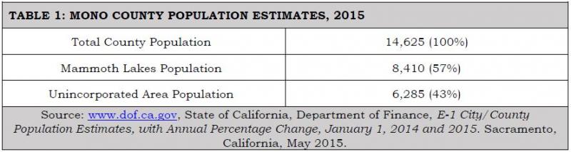
Table 2 shows population projections for the county for the next 25 years. It includes the percentage of the population 18 and older as an indicator of the number of people who may be able to drive and the percentage of the population aged 18-74 as an indicator of the number of people most likely to be driving. Over the next 25 years, the percentage of the population 18 and older is expected to increase slightly as the school age group becomes older, and the percentage of the population aged 18-74 is expected to decrease slightly as the population ages.
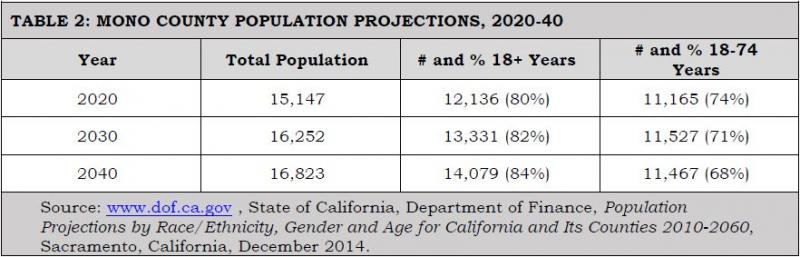
Table 3 shows population projections by community areas through the year 2040. The community projections are based on the following assumptions: that the unincorporated area will continue to house approximately 43% of the total countywide population and that the population distribution in the unincorporated community areas will remain similar to the population distribution in 2010. Antelope Valley is experiencing increasing development pressures from the Gardnerville/Carson City area; Chalfant is experiencing a similar pressure for expansion from the Bishop area; and Benton, Chalfant, and the Long Valley communities are experiencing continuing pressure from residents who work in Mammoth. As housing prices continue to rise in Mammoth Lakes, other areas of the county may experience increasing development pressure.
It is important to note that the population projections shown in Table 3 are for permanent year-round residents. Mono County, and particularly community areas such as Mammoth Lakes and June Lake, experiences much higher peak populations during periods of heavy recreational use, a factor that has a direct impact on the transportation system. Projected peak populations are utilized to determine transportation/travel demand in Mammoth Lakes and June Lake.
Assumptions: Population distribution in the county will remain as it is, with approximately 57% of the population in Mammoth Lakes, and 43% of the population in the unincorporated community areas. Population distribution in the unincorporated communities will remain as shown in Table 3. Mammoth Lakes, June Lake, Lee Vining, and Bridgeport will continue to experience much higher peak populations during periods of heavy recreational use.
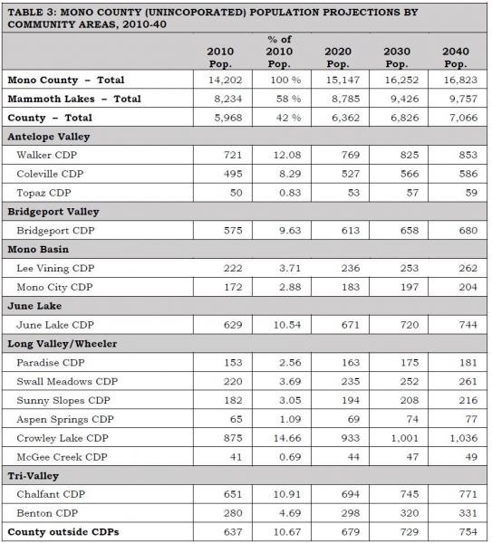
Notes: CDP is a Census designation meaning Census Designated Place. These are populated areas that lack separate municipal government but physically resemble incorporated places. In the 2010 Census, CDP boundaries were mapped based on the geographic area associated with residents’ use of the name.
Percentage of population for Mammoth Lakes and the Unincorporated Area are a percentage of the total county population. Percentagc of population for the county communities is a percentage of the total county population. Percentages for the county communities are from the 2010 U.S. Population Census and are assumed to remain similar in the future. Numbers may not equal 100% due to rounding.
Sources: www.dof.ca.gov. U.S. Census Bureau, 2010 Census, American FactFinder.
Land Use Forecasts
Unincorporated Area Development Trends
Development in Mono County communities is primarily residential with limited small-scale commercial uses serving local and tourist/recreational needs. Limited small-scale light industrial uses, such as heavy equipment storage and road yards, also occur in some county communities. Most communities also have public facilities such as schools, libraries, community centers, parks, ballfields, and government offices. County offices are located primarily in Mammoth Lakes and Bridgeport. This development pattern is not anticipated to change, due to the small scale of communities in Mono County and the lack of employment opportunities in most communities.
The Land Use Element of the county General Plan contains policies that focus future growth in and adjacent to existing communities. Substantial additional development outside existing communities is limited by environmental constraints, protected agricultural lands, a lack of large parcels of privately owned land (and lack of private land in general), and the cost of providing infrastructure and services in isolated areas. Land use policies for community areas in the county (developed by the county Regional Planning Advisory Committees) focus on sustaining the livability and economic vitality of community areas. The General Plan anticipates that growth in the unincorporated area will occur primarily in the Antelope Valley, Bridgeport Valley, June Lake, Wheeler Crest/Paradise, the Tri-Valley, and Long Valley. Traffic impacts will be most noticeable on Highways 395 and 6.
Assumptions: Development will occur in and adjacent to existing community areas that are served by existing highway systems. Traffic impacts from future development will be most noticeable on Highways 395 and 6. Town of Mammoth Lakes Development TrendsThe town of Mammoth Lakes is the county’s only incorporated community. The town is a four-season resort community with a permanent population of approximately 8,200 residents (over half of the county’s entire resident population). Vacation residences and lodging facilities accommodate a substantially larger population of second homeowners and visitors. The local economy is based primarily on tourism, especially during summer and winter months when visitation rates are highest.
The Town’s General Plan provides for extensive resort and residential development to meet recreational demand. Resort development includes lodging, commercial development, recreational facilities, and public services. The town also includes schools, a community college, a hospital, and government offices. Development in the town has been designed to accommodate peak populations that occur during high-use periods. As noted in the introduction to the Town’s General Plan:
“The ratio of permanent residents to visitors is an important element in understanding demographics in Mammoth Lakes and associated impacts. Overall, the town is prone to large fluctuations in the total non-resident population because of the seasonal nature of its tourism-dependent economy. During the winter tourist season the community and ski area require a large number of seasonal employees (more than can be filled by the full-time resident community) to meet peak service demands. As a result, the resident population increases by approximately 3,000 during the peak tourism season. The town must accommodate a much larger population when tourist populations are present. During peak tourism periods, the total number of people in town at one time exceeds 35,000 people.”
The Town of Mammoth Lakes has a defined area in which growth can occur. The Town’s General Plan provides the following information concerning the Town’s planning area and municipal boundaries:
“The Planning Area for the Town includes areas where existing or proposed facilities have a direct relationship to the current Town boundaries and services. It encompasses land in the unincorporated portions of Mono County in which the Town provides municipal services and extends from the Whitmore Recreation area on the east to the Mammoth Scenic Loop on the north. The Planning Area also includes Inyo National Forest lands located within Madera County that have their sole vehicular access through the Town of Mammoth Lakes and for which the Town provides public safety and building inspection services. The Municipal Boundary [for Mammoth Lakes] is the land contained within the incorporated limits of the Town of Mammoth Lakes. The boundary encompasses a total area of approximately 25 square miles. The Mammoth Lakes Sphere of Influence is coterminous with the municipal boundary, indicating that no additional lands are anticipated to be annexed into the municipal boundary. The Town of Mammoth Lakes adopted an urban limit policy in 1993 in order to maintain a clear delineation between the developed portions of the community and the surrounding National Forest lands. The Urban Growth Boundary policies in this plan limit residential, industrial and commercial development to those areas already designated for such uses. The ultimate size and intensity of the community would be limited to those areas not now designated for open space. The Urban Development Boundary encompasses an area of about four square miles.”
Assumptions: Development will occur within the Town’s Urban Growth Boundaries as currently designated in the Town’s General Plan. Development will occur to the buildout levels specified in the General Plan. Traffic impacts from future development will be most noticeable on Highways 395 and 203. CommutersInformation on place of work is not available from the most current U.S. Census. Historically, many county residents have not worked in the community in which they live. Residents in the Antelope Valley have commuted to work in Bridgeport and in Gardnerville, Minden, and Carson City in Nevada; residents of the Tri-Valley area have commuted to work in Bishop and Mammoth Lakes; and residents of Long Valley and June Lake have commuted to work in Mammoth Lakes and Bishop. Development in Mammoth Lakes, and rising housing prices there, have forced many residents of Mammoth to move elsewhere (Crowley Lake, June Lake, Tri-Valley, Bishop) and to commute to jobs in Mammoth Lakes.
The 2009-13 American Community Survey five-year Estimate[1] indicated 99% of workers 16 years and older residing in unincorporated Mono County worked within the state and 91% worked within Mono County. These numbers indicate a significant increase in the jobs/housing balance over 2000, when only 75% worked in the state and county (US Census 2000, Summary File 3, Tables P 31 and P32). The mean travel time to work also decreased from less than 30 minutes in 2000 to just over 16 minutes in the 2009-13 estimate. The primary means of transportation to work was a car, truck or van (67%). Of these, 54% were single-occupancy vehicles and 13% were carpools with two or more persons. Walking accounted for 14% of commuters, followed by public transportation (5%), bicycling (2.5%), and taxicab/motorcycle/other (2%). Workers from home constituted 10%.
Mono County's economy is dominated by services, retail trade, and government. Industry projections from the California Employment Development Department estimate that 85% of the job growth in Mono County between 2010 and 2020 will continue to be in services, retail trade and government (Labor Market Information, Industry Projections 2010-2020, November 2013). Major job centers are located in Mammoth Lakes (services, retail trade, government), June Lake (seasonal services and retail trade), and Bridgeport (government). Despite the availability of Commercial (C) and Mixed Use (MU) designations throughout communities in the unincorporated area, it is unlikely that sufficient jobs will develop to eliminate the need for workers to commute to jobs outside their communities.
Assumptions: The separation between jobs and housing will continue in the future due to the nature of the county's tourist-based economy. Traffic volumes will increase as this trend continues, particularly on US 395 in the southern portion of the county (June Lake, Mammoth Lakes, Crowley Lake, and Swall Meadows). Recreational/Tourist Traffic – Seasonal Use DevelopmentMono County experiences a great deal of recreational travel, both to and through the county. Most of that traffic occurs on US 395, and in the summer months on Highways 120, 108, and 89, which provide access to the area from the west side of the Sierra. Recreational traffic creates specific problems for the interregional and local transportation and circulation system, due both to the volume and type of that traffic. Winter ski weekends, particularly during peak holiday periods, result in a traffic pattern, both in communities and on highways, that simulates recurrent congestion patterns found in more urban areas. Recreational events during the summer may also create congested traffic patterns, particularly in community areas, and safety concerns with slow-moving recreational vehicles, particularly on two-lane sections of roadways. County communities are concerned about maintaining the livability of communities while providing for smoothly flowing traffic and safe traffic speeds through their communities. Recreational and tourist traffic is discussed in greater detail in the Issues and Needs section of this chapter, under the heading "Specialized Needs/Recreational Traffic."
Assumption:
As recreational use continues to expand in the Resort Corridor along US 395, visitation and travel to points of historic, cultural, and scenic beauty in other parts of the county will increase proportionately, creating a need for additional specialized transportation facilities throughout the county, including pedestrian and bicycle facilities, turnouts/vista points, rest areas, information kiosks, and parking for recreational vehicles. Safety issues associated with recreational traffic, both in communities and along highways, will remain a high priority.
Air Quality Attainment Status
Attainment StatusMono County and the Town of Mammoth Lakes meet all state and national air quality standards except for particulate matter (PM10 ) and ozone. PM10 emissions are measured at Mammoth Gateway and in the Mono Basin; ozone emissions are measured at Mammoth Gateway.
Particulate Matter (PM10)As of 2012, the county was designated as a non-attainment area for the state particulate matter (PM10) standard. Mono Basin and Mammoth Lakes are also designated as non-attainment areas for the national particulate matter (PM10) standard. Particulate matter (PM10) in the Mono Basin results primarily from dust from the exposed lakebed of Mono Lake; levels are higher on the north shore of Mono Lake than in Lee Vining due to the prevailing wind conditions. PM10 in Mammoth Lakes is a result primarily of wood burning and re-suspended road cinders during the winter.
PM10 concentrations in the Mono Basin have remained relatively stable between 2000 and 2012 with much lower concentrations in Lee Vining and higher concentrations on the north shore (see www.arb.ca.gov, PM10 Trends Summary). PM10 concentrations in Mammoth Lakes have declined significantly since the early- to mid-1990s (see www.arb.ca.gov, PM10 Trends Summary). Based on available data, Mammoth Lakes has not exceeded the national standard for PM10 since 1993, except for two times in 2013-14 due to wildfire, and has sharply reduced the number of days it exceeds the state standard (from 62.4 days in 1993 to 15 days in the 2013-14 winter season to three days in 2014-15 winter season). In 2013-14, 10 of the 15 exceedances were due to wildfire events, and in 2014-15 all were due to wildfire events.[2]
OzoneIn 1991, Mono County was designated as a non-attainment area for the state ozone standard. Ozone data collected by the State Air Resources Board in Mammoth Lakes indicate that ozone concentrations have decreased in Mammoth in recent years; the area has exceeded the one-hour State Standard only a few times during the most-recent period for which data are available, but it has exceeded the eight-hour State and Federal Standard more often [see www.arb.ca.gov, Ozone Data Summary (1988-2004)]. In the past, the State Air Resources Board concluded that ozone exceedance in the Great Basin Air Basin (Alpine, Inyo and Mono counties) was caused by transport from the San Joaquin Valley Air Basin; the Great Basin Unified Air Pollution Control District adopted an Ozone Attainment Plan for Mono County that identified the county as an ozone transport area, and required the adoption of a New Source Review Rule requiring Best Available Control Technology for emissions over 25 tons per year.
Compliance with State Implementation Plan (SIP)Regional transportation plans must conform to the requirements of the State Implementation Plan (SIP) for air quality control. The requirements for conformity apply "…in all nonattainment and maintenance areas for transportation-related criteria pollutants for which the area is designated nonattainment or has a maintenance plan" [Title 12, Section 1203 (b)(1)]. In Mono County, transportation-related criteria pollutants occur only in Mammoth Lakes (PM10 emissions resulting primarily from re-suspended road cinders and auto emissions). As a result, the Air Quality Management Plan for the Great Basin Unified Air Pollution Control District (GBUAPCD) and the State Implementation Plan (SIP) for Mono County do not include any transportation-related requirements other than for the town of Mammoth Lakes. The following section addresses plans and policies adopted by the Town of Mammoth Lakes to address air quality mitigation. Those plans and policies (including the 1990 Air Quality Management Plan, Air Quality Maintenance Plan and Redesignation Request (2014), and Municipal Code Chapter 8.30 Particulate Emissions Regulations, the Mammoth Lakes Revised Transportation and Circulation Element, and the Mammoth Lakes Transit Plan) are incorporated by reference in this RTP (see Chapter 1, Documents Incorporated by Reference).
Transportation Related Air Quality MitigationIn compliance with GBUAPCD requirements, and in consultation with the GBUAPCD and other agencies, the Town adopted an Air Quality Management Plan (AQMP) prepared by the GBUAPCD, including Particulate Emissions Regulations (Chapter 8.30 of the Municipal Code) in 1990.
Prior to 1990, the Town recorded 10 violations of the federal 24-hour PM10 standard. Following implementation of the plan in 1990, there was an immediate decline in PM10 emission; since 1994, despite continued growth, no further violations of the national standard have occurred. As a result, in 2014, an Air Quality Maintenance Plan and PM10 Redesignation Request was adopted to update the 1990 Air Quality Management Plan for the Town of Mammoth Lakes. The 2014 Plan reviews the background of the 1990 plan, the measures implemented as a result of that plan and their effectiveness, and changes to clean air regulations since the adoption of the 1990 plan. The 2014 Plan then recommends maintenance measures and requests that the Town of Mammoth Lakes be redesignated as in attainment for the federal PM10 standard.
The 2014 plan updated Section 8.30.100B of the town Municipal Code that sets a peak level of VMTs (vehicle miles traveled) at 179,708 per day within the Town, and directs that the Town review development projects in order to reduce potential VMTs. A second budget of 66,452 VMT was established for a peak winter day in the area outside of the town boundaries (unincorporated county), but inside the boundaries of the Mammoth Lakes PM10 planning area (Mammoth Air Basin). Methods to reduce VMTs include circulation improvements, pedestrian system improvements, and transit improvements. The 2014 Plan also requires the Public Works director to undertake a street-sweeping program to reduce particulate emissions caused by road dust and cinders on Town roadways.
The success of the existing control measures demonstrates that PM10 levels have been reduced and will be reduced to a sufficient degree that contingency measures are not required. Nonetheless, additional measures have been incorporated into the AQMP to assist in further reductions of PM10 levels with the goal of improved compliance with the California Ambient Air Quality Standard for PM10. These measures include amending the Town of Mammoth Lakes Particulate Emissions Regulations to match GBUAPCD Rule 431, requiring all wood-burning fireplaces and stoves, whether certified or not, to comply with no-burn days.
The Town’s Transit Plan and the Draft Mobility Element of the Town’s General Plan contain policies that are intended to increase transit ridership and reduce automobile usage. Recommended service improvements include expansion of winter transit services (peak period) for skiers and commuters, airport shuttle service, increased community transit services, year-round fixed-route services, and Dial-A-Ride services in Mammoth. Policies in the Transit Plan and Draft Mobility Element also emphasize restricting automobile parking spaces in favor of expanding the existing transit system and direct ski lift-access facilities, and incorporating transit and pedestrian facilities into existing and future developments, in order to reduce vehicle trips and improve air quality.
Assumptions: Increased traffic volumes will result in increases in pollutant emissions, particularly PM10. This will continue to be a problem in Mammoth Lakes, especially during congested periods in the winter when inversion layers trap the pollutants close to the ground. Improved transit and pedestrian services, including the incorporation of transit and pedestrian facilities into existing and future development, will help address air quality issues in Mammoth Lakes. Transportation-related air emissions will not impact other community areas in the county.Performance Conditions (LOS)
Performance conditions, or Levels of Service (LOS—see Glossary), on state and federal highways are set by Caltrans systems planning. The emphasis in District 9, which includes Inyo and Mono counties and eastern Kern County, is on maintaining and improving the interregional transportation network. Higher priorities are given to major improvements on principal arterial routes than to minor arterials or major collectors. Table 4 shows Caltrans’ planned LOS for state and federal highways in Mono County. Caltrans has been working to improve mobility on US 395, the route on which performance conditions are affected the most by traffic levels.
Performance conditions on local streets are generally not a concern since local streets typically carry only local traffic; state and federal highways serve as the main access to each community in the county and carry the greatest amount of traffic.
Assumptions: Performance conditions, or LOS, on the County’s highway system will remain as shown in Table 4, but will be re-evaluated following issuance of new guidance regarding performance measures and LOS alternatives under the California Environmental Quality Act.
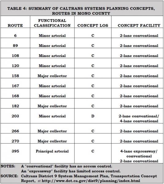
Capital Operations and Maintenance Costs
Operation and maintenance costs are addressed in Chapter 6: Financial Element.
Cost of Alternatives
The existing transportation system in Mono County includes the highway and roadway system, transit services, aviation facilities, and non-motorized facilities (generally used by locals and visitors to reduce short trips). Alternatives to the existing transportation system in the county are limited by the county’s isolation, topography, extreme weather conditions, small population, large distances between communities, large amounts of publicly owned land, and environmental constraints to developing additional facilities outside existing developed areas. Due to these factors, the existing highway and roadway system will continue to be the major component of the transportation system in the county. Development of alternative routes for highways and roadways during the 20-year time frame of this RTP is unlikely due to lack of demand for additional roads, topography, large amounts of publicly owned land, and environmental constraints to developing additional facilities outside developed areas.
The existing transportation system in the county (highway/roadway system, transit services, aviation facilities, non-motorized facilities) has been designed to accommodate increasing demand for those facilities and services over the 20-year time frame of this RTP. Demand for additional alternative methods of transportation, other than expanding and improving those currently existing in the county, is not anticipated to occur over the 20-year time frame of this RTP, given the constraints noted above.
Assumptions: It is assumed that alternatives to the existing transportation system in Mono County will not be developed during the 20-year time frame of this RTP. The Cost of Alternatives is not a relevant issue for this RTP.Time Frames
Assumptions: The short-term time frame for planning purposes for the Mono County RTP is 10 years. The long-term time frame for the Mono County RTP is 20 years.Environmental Resources of Concern
Mono County’s economy is dependent on natural resource-based recreation and tourism. Projects that detract from or degrade those natural resources are a concern. Environmental resources of special concern in relation to transportation planning and projects include scenic resources, air quality, noise, and wildlife and wildlife habitat, particularly Bi-State sage-grouse which was proposed for designation as threatened under the Endangered Species Act at one time, with critical habitat potentially covering more than 80% of private property in Mono County.
Assumptions: Mono County, the Town of Mammoth Lakes, Caltrans, and the USFS are proactive in designing and implementing projects and programs that avoid or minimize impacts to environmental resources in the county. This will continue to be a focus of project development, implementation, and management.
Complete Streets
State Law (AB 1358) requires local governments to include provisions for Complete Streets in their general plans. The Act states: “In order to fulfill the commitment to reduce greenhouse gas emissions, make the most efficient use of urban land and transportation infrastructure, and improve public health by encouraging physical activity, transportation planners must find innovative ways to reduce vehicle miles traveled (VMT) and to shift from short trips in the automobile to biking, walking and use of public transit.”
The Circulation Element must “plan for a balanced, multi-modal transportation network that meets the needs of all users of the streets, roads, and highways for safe and convenient travel in a manner that is suitable to the rural, suburban, or urban context of the general plan.” Caltrans defines complete streets as “a transportation facility that is planned, designed, operated and maintained to provided safe mobility for all users, including bicyclists, pedestrians, transit vehicles, truckers, and motorists, appropriate to the function and context of the facility.”
Assumptions: Mono County communities and the Local Transportation Commission (LTC) have been proactive in seeking transportation improvements that add to the livability of local communities. Within communities, including the town of Mammoth Lakes, Mono County's tourist-based economy can be enhanced by flexible highway designs, better facilities for pedestrians and cyclists, adequate parking facilities, reduced travel speeds, reduction of vehicle trips, and creating an environment that does not favor the automobile over other transportation modes. This will continue to be a focus of project development, implementation, and management.
Issues and Needs
Operational Issues, Including Emergency Preparedness
Emergency Response
The Mono County Emergency Operations Plan (EOP) and the Town of Mammoth Lakes Emergency Operations Plan (EOP), developed by the county and town Offices of Emergency Services, outline how emergency workers should respond to major emergencies within the county and the town. They are links in the chain connecting the detailed standard operating procedures (SOPs) of local public safety agencies to broader state and federal disaster plans. They address potential transportation-related hazards, including potential hazards from earthquakes, volcanic eruptions, floods, and hazardous materials transport. They also address emergency preparedness and emergency response for the regional transportation system, including the identification of emergency routes. Alternative access routes in Mono County are limited primarily to the existing street and highway system due to the terrain and the large amount of publicly owned land. However, the County has developed alternative access routes for community areas that had limited access (i.e., North Shore Drive in June Lake, the Mammoth Scenic Loop north of Mammoth Lakes). The County also consults with Cal Fire for emergency access requirements for new development in the State Responsibility Areas that cover most of the private property in Mono County. GIS mapping of the county and the town will enhance and support alternative route awareness for emergency responders and incident locations.
Aviation Safety
In past years, a number of airplanes have crashed in the high elevations of the Sierra. As air traffic increases, the likelihood of further aircraft accidents in the more inaccessible areas of the high country also increases. The FAA recently installed an instrumentation system at the Mammoth Yosemite Airport intended to help reduce the numbers of accidents in that area. Planned improvements at all airports in the county (e.g., lighting, fencing, taxiways, runway overruns) will increase safety at all airports.
RoadwaySafetyThe California Highway Patrol (CHP) tracks collisions in Mono County (see www.chp.ca.gov, SWITRS). Between 2001 and 2010, Mono County had an average of five fatal collisions per year with an average of five persons killed per year. During the same period, an average of 116 injury collisions per year occurred with an average of 171 persons injured. Most collisions and injuries occur from November through February and June through July, the periods of heaviest tourist visitation.
Wildlife collisions are a concern throughout the county. Figure 1 indicates collision points on US 395 that have been recorded by law enforcement agencies and Caltrans District 9, and Figures 2 and 3 indicate animal mortality by density. There is a perception of high collision rates in North County, and clear evidence of high collision rates in South County between SR 203 and Crowley Lake Drive. There is interest in projects to reduce these collisions and animal mortality rates.
Cell Phone ServiceCell phone service is poor in certain areas of the county. Due to the isolated nature of much of the highway mileage in the county and the extreme weather conditions experienced throughout the year, there is a need to ensure that adequate cell service exists throughout the county. Additional cell towers have been installed over the past several years to improve cell service in areas lacking service or with poor service; additional towers may still be necessary. Specific policies for broadband and related communication infrastructure have been developed in the Mono County General Plan Circulation Element.
FIGURE 1: 2010-13 Animal Mortality Locations on the State Highway system
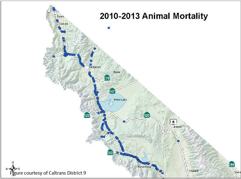
FIGURE 2: Animal Mortality Density on State Highways – North County
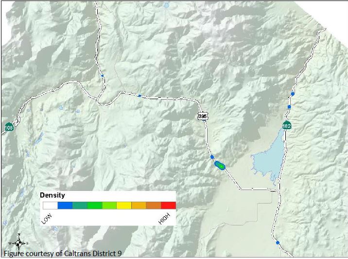
FIGURE 3: Animal Mortality Density on State Highways – South County
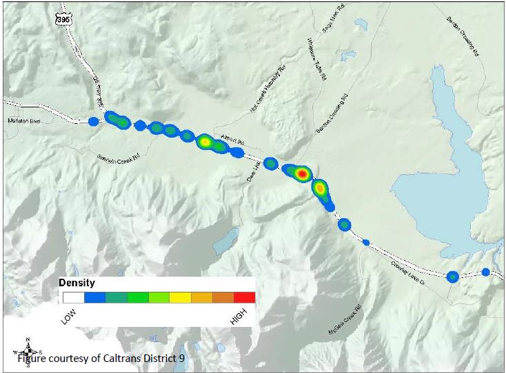
Additional transportation-related safety issues include the following:
- The potential for avalanches is a concern in community areas throughout the county, i.e., Twin Lakes, Virginia Lakes, Lundy Lake, June Lake, and Long Valley, along US 395 in the areas just north of Lee Vining, east of McGee Mountain, and at Wilson Butte between Mammoth Lakes and June Lake, and along SR 158, the June Lake Loop. In June Lake, North Shore Drive provides an alternative route into June Lake that is intended to mitigate the impacts of potential avalanches along SR 158. The LTC has recently authorized an examination of seasonal road closure policies as part of the 2014-15 proposed Overall Work Program. Of particular concern is the potential recreational access that can be provided during low-snow years, together with concerns for ensuring traveler safety.
- Increased levels of truck traffic on state highways are a safety[1] concern. US 395 and 6 are part of the National Truck Network and experience increasing truck traffic; this truck traffic can impact residential communities along these routes. In 2006, medium- and heavy-duty trucks comprised 25% of all traffic within the corridor (this and all further information on truck traffic is from Katz, 2006). Five-axle single- unit trucks made up approximately 80% of all truck traffic. The majority of southbound trucks used US 395 (61%) instead of US 6 (31%). The majority of northbound trucks used US 395 (59%) instead of US 6 (33%). Truck volumes are generally higher in the southbound direction and the average peak period for truck traffic is the midday period between 10 am and 3 pm. Safety concerns focus on the impact of oversized trucks on the safety and capacity of two-lane highway sections and the lack of paved shoulders and adequate sight distances. Narrow shoulders are a concern if vehicles must pull over for emergencies. Narrow shoulders are also less desirable for bicyclists, especially when being passed by large trucks. The recent four-laning of US 395 in various parts of the county has mitigated safety issues in those areas but concerns about truck traffic remain significant in the Tri-Valley on US 6, a two-lane road with no shoulders. The 2006 Katz study is anticipated to be updated in the near future to provide current truck traffic data and projections.[2]
- Recreational vehicle (RV) traffic creates the same safety concerns as trucks. Recreational vehicle traffic decreased from 13.4% of all traffic in the county in 1989, to 3.2% in 2000, to 1.7% in 2011 (Caltrans, US 395 Origination and Destination Report, Year 2011). A contributing factor to reduced RV use may have been the increase in average California gas prices in 2011.
- Hazardous materials spills are a concern throughout the county. The potential for such accidents is highest on Highways 395 and 6, where truck traffic is greatest. Trucks haul a variety of commodities through Mono County, with the greatest number hauling miscellaneous manufacturing products, general freight, food and similar products, farm products, and empty containers (Katz, 2006). Approximately 7% of truck traffic carries petroleum and coal products or chemicals (Katz, 2006). The Mono County Integrated Waste Management Plan contains policies to address hazardous waste spills. The Mono County Emergency Operations Plan (EOP), prepared by the Office of Emergency Services, also addresses emergencies resulting from hazardous materials spills.
- Hospitals in Mono County have limited capacity for multi-casualty incidents, and may require transport of the victims to facilities outside the county. Many accident victims with critical injuries are also transported to facilities outside the county. Access to certain areas of the County may be limited seasonally or due to weather, fire, or other such events.
Existing Regional/Interregional Transportation System
Overview
Mono County is a rural county located on the eastern side of the Sierra Nevada. The county has an area of 3,103 square miles and in 2013 had an estimated total population of 14,625 persons. The county has one incorporated area, the town of Mammoth Lakes, which had an estimated population of 8,410 in 2015. The county's other communities are scattered throughout the area, primarily along Highways 395 and 6.
Approximately 94% of the land in the county is owned by public agencies; approximately 88% is federally owned and is managed by the USFS and the Bureau of Land Management. The limited private land base restricts the growth potential for permanent residents but also provides the foundation for the county's tourist-based economy. The spectacular scenery in the county and the many varied recreational opportunities provide a tremendous recreational draw, especially for people from Southern California.
The transportation system in Mono County is typical of many rural counties. Private automobiles are the primary mode of moving people: trucks are the primary mode of moving goods. Throughout the county, the transportation system is a key support system that sustains the social, economic and recreational activities in the county. The terrain, the weather and the lack of a sufficient population base have limited other modes of regional transportation. These factors continue to limit the development of alternative regional transportation systems in the county.
Highway System
The state and federal highway system provides major access to and through Mono County, connecting communities in the county and providing access to and from the county.
US 395 is the major transportation route in the county. It connects the Eastern Sierra with Southern California and with the Reno/Tahoe region in northern Nevada. US 395 is also Main Street in Lee Vining, Bridgeport, Walker, Coleville, and Topaz, and provides access to the immediately adjacent communities of June Lake, Crowley Lake, McGee Creek, Long Valley, Sunny Slopes and Tom’s Place.
US 6, from the Inyo County line north of Bishop to the Nevada state line, connects the Tri-Valley communities of Benton, Hammil, and Chalfant to Bishop and Inyo County. US 6 is also Main Street in the Tri-Valley communities.
SR 89 provides access from US 395 to Monitor Pass and is closed in the winter.
SR 108 provides access from US 395 west to Sonora Pass and is closed in the winter.
SR 120 provides access from US 395 west to Tioga Pass at Yosemite National Park and east to Benton. The western segment is closed in the winter and the eastern segment may also be closed briefly. Within Yosemite, the road is under the jurisdiction of the National Park Service and is labeled Highway 120 (rather than State Route 120).
SR 158, the June Lake Loop, provides access from US 395 to the community of June Lake and is Main Street throughout the June Lake Loop. A segment of the loop is closed in the winter.
SR 167 provides access from US 395 to the Nevada State Line, north of Mono Lake, and to Mono City.
SR 168 provides access from US 395 at Big Pine in Inyo County north via Westgard Pass to Oasis in the southeast corner of Mono County.
SR 182 provides access from its junction with US 395 in Bridgeport northeast to the Nevada state line and provides the Main Street access to a portion of the community of Bridgeport.
SR 203 provides access west from US 395 to Mammoth Lakes to Mammoth Mountain Ski Area, serving a portion of the town as Main Street and ending near Minaret Vista Point at the Madera County line.
SR 266 provides access through Oasis in the southeast corner of the county.
SR 270 provides access east from US 395 to near Bodie State Historic Park and is closed in the winter.
US 395 is the principal route to and through Mono County. It is the only direct route to and through the county for the shipment of goods and materials. It is also the only route suitable for emergency purposes and the principal route to the county's many recreational and tourist attractions.
US 395 extends approximately 120 miles from northwest to southeast Mono County. It provides regional transportation connections to Reno and Lake Tahoe to the north, the Bay Area and the Central Valley to the west, and the greater Los Angeles area to the south. In 2014, US 395 carried annual average daily traffic (ADT) volumes of ranging from 3,550 vehicles at the Nevada state line at Topaz to 8,300 vehicles traveling southbound at the junction with SR 203. Peak month ADT volumes varied from 11,500 at the northbound junction with SR 203 to 4,600 at Sonora Junction (SR 108).
US 395 in Mono County is identified as a regionally significant part of the Interregional Road System (IRRS), as a lifeline route and as part of the National Truck Network on the National Highway System (NHS), which authorizes use by larger trucks and provides access to facilities off the route. The majority of US 395 in Mono County is also identified as a freeway/expressway.
US 6 also provides regional transportation connections in Mono County. It extends over 30 miles in Mono County – toward Bishop in the south and Nevada to the north and east. In 2014, annual ADT volumes on US 6 varied from3,500 vehicles at the junction with US 395 in Bishop to 890 vehicles at the northbound junction with SR 120 in Benton.
US 6 is a popular alternate route north when poor weather affects conditions on US 395. US 6 is identified as part of the National Truck Network on the National Highway System (NHS) and is on the eligible Interregional Road System (IRRS).
SR 120 extends approximately 75 miles through Mono County, from Tioga Pass in Yosemite National Park east to Benton. Other routes that connect to US 395 include: SR 89 (Monitor Pass), SR 108 (Sonora Pass), SR 167 (to Hawthorne, Nevada), SR 158 (the June Lake Loop), SR 270 (to Bodie), SR 182 (from Bridgeport to Yerington, Nevada), and SR 203 (to Mammoth). SR 168 and SR 266, connecting Big Pine in Inyo County and Nevada, cross the extreme southeast corner of the county.
Tioga Pass (SR 120), Sonora Pass (SR 108), Monitor Pass (SR 89) and SR 270 to Bodie are all closed during winter, as is the northern portion of SR 158, SR 203 from four miles east of the Mono County boundary with Madera County, and the portion of SR 120 between US 395 and Benton. During periods of heavy snowfall, SR 167 and the southern portion of SR 158 may also be closed. The LTC is examining seasonal road closure policies, and will seek local input on policy development. Of particular concern is the potential recreational access that can be provided during low-snow years, together with concerns for ensuring traveler safety. Figure 4 shows the existing highway system in the county.
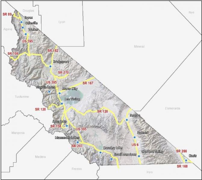
Interregional Travel Demand and Corridor Needs
US 395US 395 is, and will remain in the long-term, the major access to and through Mono County and the major transportation route in the area. It connects the Eastern Sierra with Southern California and with the Reno/Tahoe region in Northern Nevada. The primary needs for US 395 throughout Mono County are maintaining four lanes from the Inyo/Mono county line to Lee Vining; allowing for passing lane improvements to the conventional two-lane highway north of Lee Vining; safe winter access countywide; adding adequate shoulders as a priority to enable safe pedestrian and bike use, as well as increased motorist safety including potential separated-grade wildlife crossings; improved system safety and maintenance; and the development of sufficient revenue sources to meet these needs.
US 6
US 6, from the Inyo County line north of Bishop to the Nevada state line, provides regional/interregional transportation connections and is a trucking route between Southern California, Reno, and the western mountain states (Washington, Idaho, Montana). Caltrans has identified the primary purpose of the route as interregional traffic (largely trucks). The route is currently a maintenance-only route with some improvements planned for the future as traffic volumes increase and for multi-modal safety, including on-going shoulder-widening projects. The major local concerns about US 6 are safety during the periodic dust storms that occur in the area and speeds through community areas. Dust from plowed fields and from the deposits from flash floods blows across the highway, decreasing visibility. Some local landowners are working with the Great Basin Unified Air Pollution Control District to develop plans to mitigate dust problems from agricultural fields. Since the area is subject to flash floods, little can be done about dust resulting from flood deposits. An ITS dust sensor warning system to alert drivers in advance of arriving at dust storm locations might also be considered. Vehicles traveling at high speed through community areas are also a concern, both for local traffic trying to access the highway and for pedestrian safety. Vehicle speed-feedback signs have recently been installed, and there is currently interest in pursuing a Safe Route to School access across US 6 in Benton.
State Routes 120, 167, 182, 108, and 89
The remaining state highways in the county provide interregional access east and west from US 395 to Nevada and to the western side of the Sierra. State Routes 120, 108, and 89, which cross the Sierra in high mountain passes, are closed in winter. The main concern on these routes is continued adequate maintenance, including timely road openings following winter closures and intermittent access during low-snow years.
Mountain Passes
There is some interest in attempting to keep the mountain passes (Tioga, Sonora, and Monitor) open as long as possible, including opening the passes as soon as practical, in order to increase access from the west and provide an economic boost to local communities. The County coordinates with Caltrans and Yosemite National Park to keep Tioga Pass open as long as possible. Residents in communities near Sonora and Monitor passes are also interested in keeping those passes open as long as possible.
Average Daily Traffic Volumes
Table 5 shows Average Daily Traffic (ADT) volumes on Mono County Highways in 2009 and 2014. Between 2009 and 2014, traffic volumes increased on many of the County’s highways, particularly on the county’s most heavily traveled routes (i.e., US 395, US 6, and SR 203).
[1] According to comments by Caltrans District 9 in Dec. 2015, truck traffic safety issues have not been identified based on system data.
[2] Note: The Mono County Board of Supervisors adopted slightly different language in the Mono County General Plan Circulation Element for this bullet point. See the “2015 Circulation Element Errata Sheet.”
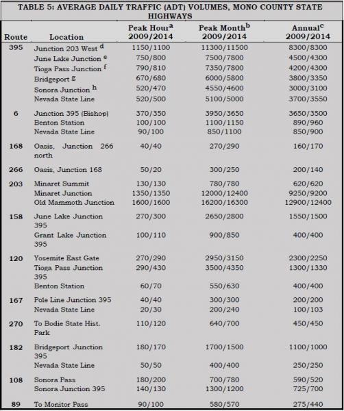
Table 5 Notes:
- These are estimated figures.
- The peak month ADT is the average daily traffic for the month of heaviest traffic flow.
- Annual average daily traffic is the total traffic volume for the year divided by 365 days. Some routes are regularly closed for one month or more during winter; ADT figures for those routes reflect travel when the route is open. Routes regularly closed during the winter include the following:
SR 89 – Monitor Pass, Jct. US 395 to Jct. SR 4, 17.5 miles.
SR 108 – Sonora Pass, six miles east of Strawberry to seven miles west of Jct. US 395, 35 miles.
SR/Highway 120 – Tioga Pass, Crane Flat to five miles west of Jct. US 395, 55 miles.
SR 120 – Mono Mills Road, two miles east of Jct. US 395 to six miles west of Jct. US 6, 37.6 miles.
SR 158 – June Lake Loop, Powerhouse to north Jct. US 395, 8.6 miles.
SR 203 – Mammoth Lakes Road, Mono/Madera county line to one mile east.
SR 270 – Bodie Road, Jct. US 395 to Bodie, 9.8 miles.
- Reflects traffic turning into Mammoth. Counts on 395 going north from 203 are lower.
- Reflects traffic turning into June Lake. Counts on 395 going north from 158 are lower.
- Reflects traffic from SR 120 north on 395 toward Lee Vining.
- Reflects traffic going north out of Bridgeport.
- Reflects traffic going north from the Sonora Junction
SOURCE: Caltrans 2009 and 2014 Traffic Volumes on California State Highways.
Specialized Needs
Recreational TravelMono County experiences a great deal of recreational travel, both to and through the county. Most of that traffic occurs on US 395. In the summer, additional traffic occurs on State Routes 120, 108, and 89, which provide access to the area from the west side of the Sierra. Recreational traffic creates specific problems for the local transportation and circulation system, due both to the amount and type of that traffic. Winter ski weekends, particularly during peak holiday periods, result in a congested traffic pattern, both in communities and on the highway, which simulates rush-hour traffic patterns found in more urban areas. Recreational events during the summer may also create congested traffic patterns, particularly in community areas.
Recreational travelers have special needs, such as turnouts/vista points, rest areas, and information about local recreational areas, interpretive information, lodging, and travel routes. Recreational travelers also create safety concerns on local and state highways and roads; sightseers often travel slowly, disrupting the traffic flow, and may stop along the road to enjoy the view or take photos, creating a hazardous situation. Recreational vehicles (RVs) travel slowly on the many steep routes in the area, disrupting traffic flow, particularly in areas where the road is only two lanes. In community areas, RVs often have difficulty parking or use more than their share of limited parking spaces. RVs account for 1.7% of the traffic in Mono County on US 395, a decline from a high of 13.4% in 1989 and 3.2% in 2000 (Caltrans, US 395 Origination and Destination Report, Year 2011).
Results from the 2011 US 395 Origination and Destination Report showed some changes since the prior two reports, i.e.:
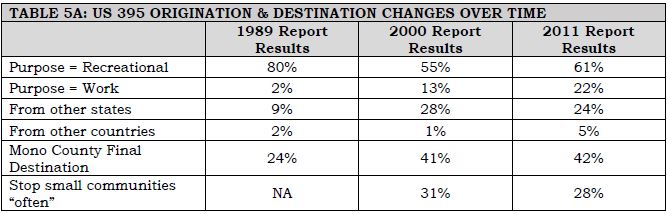
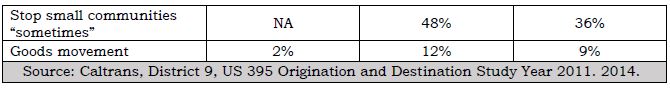
Many of the needs of recreational travelers have been addressed by recently completed or ongoing projects. The four-laning of US 395 to Lee Vining has eliminated many of the problems resulting from slow-moving vehicles. Transportation enhancement projects related to the Eastern Sierra Scenic Byway have provided turnouts and information for travelers. The June Lake, Mono Basin, and Bodie Hills Transportation Plans address parking in community areas and transportation linkages between communities and recreational areas.
Disabled PersonsThe Americans with Disabilities Act (ADA) requires public and private transportation projects to comply with the ADA. This requires that transportation facilities are accessible to disabled persons; e.g., pedestrian facilities, parking areas, turnouts, kiosks, etc. must be wheelchair- accessible. All transit services must also comply with the requirements of the ADA. The ADA requires the availability of wheelchair lift-equipped fixed-route buses and door-to-door service for disabled persons who cannot use the fixed-route service. ESTA buses are equipped with wheelchair lifts and also provide door-to-door demand-responsive service.
Goods Movement
Goods movement to and through Mono County occurs on the interregional highway system; i.e., US 395 and US 6. There are no railroads in the county and no air freight services. As noted previously, US 395 in Mono County is identified as part of the National Truck Network on the National Highway System (NHS), which authorizes use by larger trucks and gives them access to facilities off the route. US 395 provides regional transportation connections and truck access between Southern California and Reno, Nevada.
US 6, from the Inyo County line north of Bishop to the Nevada state line, provides interregional transportation connections and is a trucking route between Southern California and the western mountain states (Washington, Idaho, Montana). It is also identified as a part of the National Truck Network, and Caltrans has identified the primary purpose of the route as interregional traffic (largely trucks).
In 2006, medium- and heavy-duty trucks comprised 25% of all traffic within the corridor (this and all further information on truck traffic is from Katz, 2006). Five-axle single-unit trucks made up approximately 80% of all truck traffic. The majority of southbound trucks used US 395 (61%) instead of US 6 (31%). The majority of northbound trucks used US 395 (59%) instead of US 6 (33%). Truck volumes are generally higher in the southbound direction and the average peak period for truck traffic is the midday period between 10 am and 3 pm. The 2011 Origination and Destination Report conducted by Caltrans found that tractor trailers totaled 9.1% of total vehicles, a decrease from 11.5% in 2000.
Local Corridor Needs
OverviewLocal corridor needs include state highways that serve primarily local traffic (i.e., they do not provide interregional connections), County roads, city streets, and public roads operated by various other local, state, and federal agencies. Table 6 shows the mileage of maintained public roads in Mono County. Local corridor needs in the town of Mammoth Lakes are discussed later in this chapter under the heading Town of Mammoth Lakes.
SR 203 provides access from US 395 to Mammoth Lakes, to Mammoth Mountain Ski Area, and continues as a road owned and operated by the USFS to Reds Meadow and Devils Postpile in the summer months. Congestion on 203 in Mammoth Lakes and between town and the ski area continues to be a problem in winter, resulting in adverse air-quality impacts, primarily from resuspension of road dust and cinders and auto emissions. Traffic is also heavy during certain periods in the summer. Congestion, and the resulting air-quality impacts, is the major concern on SR 203.
State Route 158SR 158, the "June Lake Loop,” provides access from US 395 to the community of June Lake. There are operational and safety concerns on this route, particularly in the Village and Down Canyon areas of June Lake. These concerns focus on easing congestion in the Village by providing alternate routes; providing for alternatives to the automobile; and providing safer routes for non-motorized forms of transportation.
County RoadsThe county currently has 684.42 miles of County-maintained roads (County Road System Maps are included in Appendix E). Of that maintained mileage, 179.07 miles are paved, 168.47 miles are plowed in the winter, and 197.87 miles traverse National Forest lands. Although most of the County roadway system is already established, there remains a need for new facilities. These needs are generally addressed in the community policy section (e.g., June Lake) in order to complete the circulation system, provide for emergency access, avoid congestion and provide for continued growth. The main access to all communities in the county is state highways, i.e., US 395, SR 158, and US 6.
In addition to the County roads, there is an extensive network of private and federally controlled roads in the county, many of them unimproved. The federal roads, on lands managed by the USFS and BLM, are mostly unmaintained dirt roads that receive limited use from logging trucks and off-highway vehicles (OHVs). The USFS and the BLM have developed management plans for OHV use. The private roads in the county are mostly in community areas; many of them are substandard roads that do not meet the county Roadway Standards and as a result have not been accepted into the county Roadway System.
Substandard roads are a particular problem in June Lake. In 1981, the Mono County Public Works Department recognized the Loop's existing constraints to roadway construction and developed a special set of arterial/commercial and collector/residential road standards tailored to meet those constraints. These standards permit lower design speeds and narrower roads than in other areas of the county.
Major development projects have been able to comply with these standards, however the costs of upgrading older roads will continue to preclude their improvement and ultimate acceptance into the County maintenance program. This is true throughout the county. Property owners on private roads will continue to bear all maintenance costs, as private roads do not qualify for state and federal maintenance funding.
On County roads, the primary needs for local streets and roads are snow removal, regular pavement maintenance and major rehabilitation. Heavy snowstorms, rapid freeze-thaw deterioration and heavy visitor traffic create an unusually high demand for snow removal and regular annual maintenance. The Public Works Department maintains and updates annually a snow-removal priority list for County roads. The Mono County Road Department currently provides road surface and shoulder repair, signing, striping and snow removal, as well as minor and major improvements such as road surfacing and alignment improvements. Operating revenues that support these services are provided through various state and federal revenue- generating programs, including state gas taxes, vehicle code fines, timber receipts, federal and secondary funds, transportation allocations, and motor vehicle license fee taxes. Due to dwindling revenues for road maintenance, Mono County is implementing a regional asset management strategy to ensure efficient expenditure of limited resources in maintaining the local road system.
The potential impacts of large-scale future development on the County road system continue to be a major concern. Traffic volumes of future development may impact portions of the existing road system. There is a need for mitigation of future impacts to the transportation system and for a standardized means of assessing potential impacts from future projects.
Roads on Native American LandsThe transportation systems serving the Bridgeport Indian Colony and the Benton Paiute Reservation include the State Highway System, County roads, tribal roads, and roads managed by the Bureau of Indian Affairs. Transportation needs for each location include road upgrades, ongoing road maintenance, and new road construction to serve existing and proposed development (see Nelson\Nygaard, Tribal Transportation Needs Assessments).
Maintenance of the Existing Regional/Interregional Transportation System
Maintenance of the existing regional and interregional transportation system is discussed in the Action Element.
Traffic Demand, Mono County
Traffic demand projections for the unincorporated areas of Mono County are based on potential trip generation rates of projected residential land uses. The methodology used to compute those projections is explained in detail in Appendix A – Traffic Demand Projections, Unincorporated Areas. Table 7 summarizes the data presented in Appendix A.
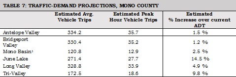
The analysis in Appendix A notes that the estimated increases over current Average Daily Traffic (ADT) figures are not significant increases. North Shore Drive into June Lake is expected to help mitigate the larger expected traffic increase in June Lake.
Demand Management Strategies
Transportation Demand Management (TDM) refers to measures designed to reduce vehicle trips, trip lengths, and congestion. TDM encourages wider use of transit, vanpools, carpools, and other alternatives to the single-occupant automobile. TDM measures provide alternatives to large investments in new highway and transit systems, which are limited by lack of money, adverse community reactions, and other factors. TDM measures are designed to modify travel demand patterns, resulting in lower capital outlays. They may be implemented within a short time frame and evaluated quickly. Several policy issues arise in determining the extent to which TDM may be used to reduce congestion, including the effectiveness of voluntary vs. mandatory measures, and the need to apply them only to new development or to all employers of a specific size.
The transportation system in Mono County does not experience severe congestion except in limited areas, and at limited times. Due to a number of factors, some TDM measures are not particularly viable options in the unincorporated areas of Mono County at this time. Bicycling is generally not a year-round option for commuters in many areas of the county due to the long distances traveled and severe winter weather conditions. There is some potential in county communities to increase pedestrian facilities; the County is pursuing funding to convert county communities (i.e., Crowley Lake, Lee Vining, June Lake, Bridgeport, and Walker/Coleville) to more livable/walkable communities.
Mammoth Lakes is committed to becoming a multi-modal community where automobile usage is minimized due to efficient pedestrian and transit systems. The Town has downsized roads to make room for sidewalks and bike lanes, increased transit facilities, and developed park-and- ride facilities. In addition, the Town has greatly expanded its trail system for pedestrians, bicyclists, and Nordic skiers.
Due to the high number of people who work outside the community in which they live, opportunities exist for ridesharing in the county and the town. Currently, Mammoth Mountain Ski Area provides vanpooling and shuttle services for its employees, ESTA offers vanpool opportunities, County employees voluntarily carpool to Bridgeport and Mammoth, and informal park-and-ride areas are in use throughout the county (e.g., at the junction of SR 203 and US 395 and at June Lake Junction). Mammoth has a designated park-and-ride facility in the town.
The use of transit for commuter and everyday transportation demand management purposes in Mono County is somewhat limited due to the long distances traveled and the relatively small population base. Outside Mammoth Lakes, transit use within community areas is generally not a viable option. Transit service to recreational destinations, however, is a viable TDM measure in Mono County. Shuttle service to Devils Postpile National Monument and trolley service to the Lakes Basin has been in place for many years in order to reduce traffic impacts. The Yosemite Area Regional Transportation System (YARTS) provides shuttle service from Mammoth Lakes, June Lake, and Lee Vining (and other counties surrounding Yosemite National Park) to Yosemite Valley and now specifically to Tuolumne Meadows.
Recent technological advances, such as Digital 395, may also contribute to transportation demand management. As more people are able to conduct their business electronically via the Digital 395 broadband middle-mile telecommunications networks, commuter travel demand should decrease.
Parking Management
Mono County's Land Development Regulations in the General Plan generally require on-site parking in the unincorporated area, developed in compliance with standards in the Regulations. Single-family residences must provide two parking spaces and other uses must provide a specific number of parking spaces based on the intensity of the use. Most parking provided in commercial areas is uncovered, either on-street parking or parking lots. As a part of its General Plan update, the County has revised its parking standards to allow for greater flexibility in meeting parking requirements in established central business districts.
Parking standards in Mammoth Lakes are listed in Title 17 (Zoning) of the town Municipal Code. A minimum of three off-street spaces (at least 50% enclosed and at least one unenclosed space) is required for single-family residences. The parking requirements for multi-family are based on the number of bedrooms and require that 50% of the required parking is enclosed. Non-residential parking requirements are dependent on which parking zone the project is located in and the proposed land use, and has a minimum and maximum number of spaces allowed. Non-residential parking is encouraged to be located underground, behind a building, or on the interior side or rear of the site to improve the aesthetics of projects and to encourage pedestrian facility use. The Town completed a parking analysis (2014) as part of the Zoning Code update, which focused on developing parking standards that meet the needs of the community by focusing on actual observed parking demand rates while preventing the over-supply of parking. The results of the analysis were incorporated into the Zoning Code and included such items as shared parking, allowing parking requirements to be met off site, allowing parking reductions for mixed-use development, and enacting design standards that can minimize the impact that parking has on the physical environment.
Parking issues and needs include the following:
- Review of proposals for commercial business expansions has shown an inability to meet the parking regulations of commercial build-out in established central business districts in communities such as Bridgeport, Lee Vining, and June Lake. Parking regulations were recently revised to promote alternative means to meet the trip generation impacts of patrons of new or expanded commercial developments. Revised regulations allow for consideration of pedestrian, transit and bike accommodations in lieu of providing some parking spaces. Parking for buses and large trucks will continue to be a problem in some areas. Future development, particularly of recreational areas and associated commercial uses, will likely increase the demand for parking facilities.
- On-street parking is also a problem in some areas and creates safety concerns. In the winter, on-street parking may hinder snow-removal operations. In some communities, on-street parking of large trucks creates a nuisance. The Bridgeport Main Street planning project addressed these issues via an innovative reconfiguration/reduction of travel lanes and parking spaces that encourages slower traffic speeds and converted former travel lanes into a combination of parallel and back-in angle parking. Parking restrictions continue to apply in the winter during specific hours to allow for snow removal.
- Some communities would like to see the creation of community parking areas instead of requiring all businesses to develop small individual parking areas. At one time, there was also interest in Lee Vining to consider developing or designating a site for large truck parking.
- Mammoth Lakes has inadequate parking to meet current and projected future demand. The 2005 Parking Study Draft recommends encouraging shared parking, developing two smaller parking facilities for the Village, developing a public parking facility for the southern portion of the town that could also serve as a park-and-ride lot, developing a public parking lot/park-and-ride location on the north side of Main Street, developing a small parking lot on the south side of Main Street between Manzanita Road and Joaquin Road, developing a roundabout or a traffic signal on Main Street to aid pedestrians crossing to park-and-ride lots, and considering the provision of one or two small park-and-ride lots in the Mammoth Camp/Snowcreek/Starwood areas.
Environmental and Energy Impacts
Impacts Resulting from Transportation System ImprovementsEnvironmental impacts resulting from improvements to the transportation system will be limited in Mono County since much of the system is already in place. Road development occurs primarily in developed community areas or adjacent to existing highways. Mono County RTP and General Plan policies focus development in community areas and encourage the use and improvement of existing facilities, rather than construction of new facilities. RTP policies take into account sensitive habitats that have been mapped as part of the companion EIR. General Plan policies require future development with the potential to significantly impact the environment to assess the potential impact(s) prior to project approval and to recommend mitigation measures to avoid, and to mitigate the identified impacts, both on-site and off-site. The previous requirement also applies to potential impacts to the transportation system. In addition, RTP and General Plan policies promote preservation of air quality and scenic resources.
Environmental Mitigation Measures and Enhancement ProjectsCaltrans, the U.S. Forest Service (USFS), the Bureau of Land Management (BLM), the California Department of Fish and Wildlife (CDFW), the Local Transportation Commission (LTC), the County, the Town of Mammoth Lakes, and other interested agencies and organizations have been working together to incorporate environmental mitigation measures and enhancement projects into the planning process for road improvements to both state and local circulation systems. Environmental enhancement grants have been received for several projects, including the Eastern Sierra Scenic Byway and the Mammoth Lakes Trail System.
RTP policies encourage appropriate agencies such as Caltrans, the USFS, the BLM, the CDFW, the LTC, the County, and the Town of Mammoth Lakes to work together to define environmental objectives, to design transportation projects in a manner that improves both the transportation system and the surrounding community and/or natural environment, and to incorporate environmental mitigation measures and enhancement projects into the planning process for transportation improvements to both state and local circulation systems. Community areas have been assessed for habitat values and mitigation measures incorporated into policies and directives to allow for streamlined environmental processing via tiering from the RTP EIR.
Impacts to Local Wildlife from Increased Use of SystemIncreased use of the transportation system may result in impacts to local wildlife. Limited visibility, road speeds, migration paths and driver error result in road kills of deer, rodents, mammals and birds. Caltrans has long endeavored to solve this dilemma by designing roadways and highways in a manner that increases visibility and by limiting the amount and type of vegetation along the shoulders. They have been diligent in providing ample signing opportunities to warn the unaware driver of the deer migration paths and nearby habitats. Caltrans is continuing to assess the potential benefits of additional signing and other measures. Deer crossings under highways have proved effective in some areas, but they are costly and several miles of tall fencing are needed on each side of the crossing to be effective. They have been considered in the area north of the Sonora Junction on US 395 and are currently under consideration along US 395 south of Mammoth Lakes.
Climate Change
Potential impacts from climate change in the Eastern Sierra include flooding, a substantially reduced snowpack, related economic impacts due to declines in tourism, and impacts to ecosystems and biodiversity.[1] There is a need to assess potential related effects on the transportation system, to determine whether there are critical assets that should be protected, and then to develop and implement adaptation strategies to address those potential impacts.
Resource-Efficient Transportation System/Greenhouse Gas Reduction
Mono County had developed a Resource Efficiency Plan (REP) in order to identify the most effective and appropriate greenhouse gas (GHG) emissions reduction strategies. The plan includes: 1) a baseline GHG emissions inventory; 2) a GHG emissions forecast and reduction target; 3) policies and programs to achieve the adopted target; and 4) a monitoring program. The REP is incorporated by reference in this RTP; policies and objectives included in the Plan have been included in the policy section of this RTP. Policies addressing issues related to climate adaptation including flooding, reduced snowpack (and water availability), economic issues, and ecosystems and biodiversity, are contained in the Mono County General Plan Land Use Element and Conservation/Open Space Element.
Community Needs and Issues
This section outlines transportation concerns that have been identified by communities and Regional Planning Advisory Committees as being important issues in their communities.
Antelope Valley (Topaz, Coleville, Walker)- The priority concern in the area is safety improvements on US 395 and Eastside Lane. Residents would like to see turn lanes at heavily used areas on US 395, such as the high school in Coleville, and possibly at the intersections with Larson Lane, Cunningham, and Topaz Lane. On Eastside Lane, the safety concern is the first turn on Eastside north of its intersection with US 395.
- Residents of the Antelope Valley consider their existing community road system, much of which is unimproved private roads, to be adequate. However, existing private roads that are functioning as public roads should be brought up to standard.
- Residents question the need for four-laning US 395 in the Antelope Valley, especially since Nevada presently has no plans for four lanes. Residents would prefer that the route remain two lanes with operational improvements such as shoulder widening, fences and underpasses for deer, and potentially some landscaping. Residents are also interested in retaining the scenic qualities of US 395 between communities.
- There is a great deal of interest in a loop bike route throughout the Valley for use by touring bicyclists. There is some interest in providing facilities for pedestrians and equestrians along a similar loop route. There is some interest in providing mountain biking opportunities along the West Walker River, for example, from the Sonora Bridge to Walker, along the river and/or parallel to Burcham Flat Road.
- Residents of the area would like greater enforcement of vehicles passing in unsafe areas throughout the Valley.
- There is a need to consider the installation of call boxes where cell service is lacking or where it is unlikely cell service would ever be successful due to topography.
- Restricting fence design to facilitate the migration and movement of wildlife, with particular attention given to deer migration routes, Bi-State sage-grouse impacts, and protection from highway traffic.
- Establishing a speed limit of 25 mph on all secondary roads.
- Limiting development of new secondary roads to those necessary for access to private residences; minimizing the visual impact of roads, using construction practices (drainage, culverts, road bases and finishes) that minimize dust and erosion problems; and prohibiting construction on designated wet meadow areas.
- Residents of Bridgeport, working with consultants and Mono County, recently completed a Main Street Revitalization Plan for US 395 through Bridgeport. That plan addresses many of the concerns outlined below.
- Residents of Bridgeport are concerned about pedestrian and bicyclist safety along Highways 395 and 182 from the Evans Tract to the dam at Bridgeport Reservoir and State line. The residents recommend as priority items a bike lane on SR 182, and widening the shoulder along Highway 395 from the Evans Tract to SR 182.
- Other safety concerns include enforcement of the speed limit through the town and the design of several intersections, including the SR 182/395 junction, the Emigrant Street junction with US 395, and the Twin Lakes Road junction with US 395 south. The number of deer kills on Twin Lakes Road from the start of the Hunewill Hills to Twin Lakes is also a concern.
- Parking is a problem on Main Street and around the County buildings, especially during the months with the most visitors and when court is in session. There is some interest in providing additional off-street parking for county employees, people attending court, and visitors to the area, possibly next to the Probation Department or on empty lots on Emigrant Street.
- There is interest in developing a bike lane connecting Bridgeport and Twin Lakes, either by widening the shoulder or by creating a separate bike path that parallels the existing roadway.
- There is interest in eventually developing local bike trails and/or loops, and hiking/pedestrian trails, in Bridgeport and the surrounding recreational areas.
- There is a need to consider the installation of call boxes where cell service is lacking or where it is unlikely cell service would ever be successful due to topography.
Bodie Hills[2]
- Issues in the Bodie Hills include improving transportation facilities and upgrading parking facilities, particularly for buses, at Bodie State Park. The Bodie Planning and Advisory Committee (which is no longer active) has recommended the use of unique and historically compatible modes of travel to Bodie, such as reactivating the old railroad grade from Mono Mills to Bodie, providing for equestrians and horse-drawn wagons and carriages in the state park, and establishing a trail system in the Bodie Hills that provides for equestrian, cycling and pedestrian use.
- Transportation improvements into the park and in the area surrounding the park are also needed. Recommendations include paving the Bodie Road up to the cattle guard, having it accepted into the State Highway system at the edge of the Bodie Bowl and designating SR 270 as a scenic highway with turnouts and interpretive displays. Paving Cottonwood Canyon Road to Bodie is recommended to reduce dust. If visitation continues expanding beyond the carrying capacity of Bodie State Park and to accommodate wintertime visitors, an interagency visitor center and office complex in the Bridgeport town site is recommended. There is some interest in a satellite parking facility and shuttle service outside the Bodie Bowl.
Mono Basin[3]
- Maintain the small-town quality of life for residents.
- Increase tourism opportunities – develop Lee Vining as a destination rather than a quick-stop highway town.
- Improve visitor services.
- Maintain and increase the attractiveness of the community.
- There is an opportunity to enhance the visual appearance of Lee Vining along US 395. Enhancements may include: landscaping, raised pedestrian crossings with variations in pavement texture/appearance, street furniture, revised parking configurations, and provisions for the convenient loading and unloading of tour buses.
- The Caltrans and Mono County road maintenance facilities detract from the appearance of the Lee Vining commercial district. There is an opportunity, if these facilities are relocated, to redevelop those properties in a manner that contributes to an attractive Main Street appearance. There is also opportunity to coordinate road maintenance facility needs of other entities, such as Mono County and the USFS, with the relocation of the Caltrans shop. If these facilities are not relocated, which Caltrans indicates is infeasible in its comments on the Draft EIR, there is a need to continue enhancing their appearance through landscaping, solid fencing, painting, etc. and provide connectivity to public facilities to the north and east.
- There is an opportunity to balance competing needs through reengineering the five-lane section of US 395 through Lee Vining. Competing needs include: convenient parking for business patrons; slower traffic, bike lanes and pedestrian facilities for residents; traffic flow in front of businesses; and convenient interregional travel for motorists traveling through Mono County.
- The community is interested in developing visual interest and gateway-design elements at the north and south entrances to Lee Vining.
- The community is concerned about balancing community goals, such as pedestrian safety and comfort, roadway aesthetics, and community economics with the need to move traffic safely and efficiently along US 395.
- There is a desire for pedestrian improvements throughout Lee Vining and adjacent areas. These improvements may include:
- Safe pedestrian crossings across US 395 in Lee Vining. Improvements to slow traffic may include: variations in pavement surface, raised intersections, reconfigured traffic lanes, flashing caution lights, and crosswalk landmarks.
- In accordance with state laws and procedures, post and enforce slow speed limits along US 395 within Lee Vining to minimize conflicts with pedestrians crossing the highway. Speeds in Mono City should also be lowered to minimize conflicts within the residential neighborhood.
- Additional pedestrian trails to and from local activity nodes, such as the Mono Basin Visitor Center and Mono Lake.
- There is need for bikeway improvements throughout the Mono Basin. There are opportunities to include wider shoulders adequate for bike use as part of scheduled road projects and to provide other improvements for cyclists.
- Lee Vining lacks adequate parking facilities for visitors and buses in the summer months. Much of the existing commercial district lacks sufficient area for on-site parking. Trucks parked throughout the community with idling engines cause air and noise pollution and detract from the attractiveness of the community. Potential solutions to these issues include the following:
- Restrict truck parking and engine idling in certain areas of Lee Vining and consider siting a truck parking facility in the region.
- Parking standards tailored to meet Lee Vining's unique conditions have recently been adopted.
- Acquire land and develop one or more community parking areas for the Lee Vining business district. The existing Caltrans and County road shops, when vacant, could serve as community parking areas.
- Design parking facilities to enhance the appearance of the business district. Design standards should ensure that future parking areas are well landscaped, sited in scale with adjacent structures, and appropriately buffered from adjacent sensitive land uses.
- There is a need to consider future expansion of Lee Vining when determining community parking needs.
- SR/Highway 120, both west through Yosemite and east to Benton, is closed in the winter. There is local interest in keeping both sections of the highway open longer and in maintaining SR 120 east to Benton for winter access. There is a need to consider different approaches to increasing funding and responsiveness to maintenance needs on Highway 120 through Yosemite, including:
- Organizational options, such as Caltrans assuming maintenance responsibility.
- Establishing a Tioga Pass Authority to maintain the road.
- Using Park fees for road maintenance.
- There is a need to provide safe access around avalanche hazards on US 395 just north of Lee Vining. An avalanche bypass road north of Lee Vining would funnel traffic through the Mono Basin Visitor Center and could also improve access to the tufa area just north of the visitor center.
- Local transit services could be expanded and improved to better link Lee Vining and Mono City with other communities along the US 395 corridor. Local transit should also link Lee Vining with other eastside attractions such as Bodie, South Tufa, and the Lee Vining Airport. Transit vehicles should provide storage for bicycles and backpacks.
- Low-cost backpacker shuttles should be considered to reduce multi-day parking.
- As one of the closest public airports to Yosemite National Park, Lee Vining Airport has the potential for increased use by visitors to Yosemite. The County has recently updated the airport master plan, along with the airport land use plan, in order to coordinate improvements and land uses for the airport vicinity.
June Lake[4]
- SR 158, a two-lane County-designated scenic highway, and the June Lake Loop's major roadway, experiences traffic congestion during peak periods in the winter and summer. Winter travel is further hindered by winter weather conditions.
- Traffic congestion is expected to increase as a result of improvements to June Mountain Ski Area and associated development. Increased traffic will aggravate congestion and conflicts between vehicles and pedestrians, as well as the frequency of accidents.
- Steep slopes, sensitive environmental habitats, and a limited right of way hinder the widening of SR 158.
- Small lot configurations, building encroachments into setbacks, and fragmented ownership impede roadway improvements. The inability to provide adequate access to some private lands will limit the development potential of those lands.
- June Lake Village – the central commercial and retail district – lacks a cohesive and integrated system for traffic, parking, and pedestrian circulation. Also, Caltrans reports that the rate of accidents along SR 158 in the June Lake Village exceeds the statewide average for similar highways.
- Parking in the Loop's commercial centers and at recreational facilities is limited or restricted. The lack of adequate parking aggravates traffic flow, creates traffic safety hazards, and may constrain tourist sales revenues as well as future development. In winter, on-street parking hinders snow removal and internal circulation.
- Snow removal on SR 158 in the Village during business hours causes a perception of traffic delays and must adequately remove and manage snow in order to prevent parking problems for residents and businesses. Snow-storage sites have not been established. At times, pedestrians must share plowed roadways in the Village with vehicles, increasing traffic congestion and safety hazards.
- The limited circulation system creates both internal and external circulation problems. Restricted internal circulation could hamper firefighting or other emergency efforts. Limited external access, i.e., mobility between the Loop and US 395, could hinder evacuation efforts in the event of a major catastrophe.
- Many June Lake Loop roadways feature improper grading, shoulder improvements, setbacks, and roadway design. These features not only increase the cost of maintenance, repair, and snow removal, but also limit access for emergency service vehicles and add to erosion and traffic circulation problems.
- Sidewalks along both sides of SR 158 through the Village are the only existing pedestrian features. Sidewalks feature either an asphalt or concrete surface and vary in width from approximately 4' to 7’ on both sides. Obstructions such as stairs with handrails to individual businesses, driveways to individual businesses, portable business signs, and signposts, clutter the sidewalks.
- Field surveys with Caltrans personnel have indicated that a June Lake Village project featuring a connector road, community parking lots, and pedestrian improvements could qualify for MAP-21 or ATP funding due to its multi-modal aspect of relieving traffic congestion.
- Many roadway easements were drawn without regard for the existing topography or the feasibility of constructing future roadways. Numerous property owners abutting "unbuildable" roadway easements have applied to abandon the public's interest in existing paper roads. The Street and Highway Code establishes the procedure for the County to abandon its interest in public rights of way. Under the Code, roads eligible for abandonment must be impassable and the County must not have expended public funds on the road in the last five years. The county Board of Supervisors vacates public rights of way on a case-by-case basis after receiving a petition from adjacent property owners, noticing adjacent property owners about the proposal, and holding a public hearing on the proposed vacation. There is an opportunity to identify routes that may be vacated.
- After the County vacates the public interest in rights of way along street easements, the property under the former easement reverts to the property owners adjoining the former road easement. Street abandonment often benefits property owners adjacent to roadways by enlarging existing parcels and providing more area for development.
- The County's vacation of road rights of way could hinder future fire protection or emergency-service efforts by limiting access. Abandonments could also hinder the activities of the June Lake Public Utility District or Southern California Edison, which currently use existing roadway easements for access and for the location of sewer, water, and electrical facilities.
- The June Lake Loop lacks distinctive street signs that blend in with the mountain character of the community. As part of the 911 emergency response program, the County has started to install common street signs throughout the county. The signs are constructed out of redwood and mounted on a single 4 x 4 wooden support post. The signs are brown in color and feature white letters routed into the sign face.
- Public transportation in June Lake is limited. There is an opportunity to increase transit access to and throughout the June Lake community including the summer time YARTS Yosemite Area Regional Transportation System) stop in June Lake.
- The June Lake Loop can greatly benefit from improved and expanded pedestrian trails to improve safety, to increase pedestrian traffic in commercial areas, and to expand the range of recreational opportunities. Currently, most of June Lake's trails are on public lands managed by the USFS and provide access to destinations outside the community. There is an opportunity for pedestrian trails on private lands to link major commercial centers with residential development, lodging facilities and recreational nodes.
- Cross country ski trails, which are limited in the Loop, could link future development and provide an alternative to automobile travel.
- Potential Nordic ski trail alignments in the Loop are severely limited by avalanche dangers. Other factors limiting trails include the availability of snow on a consistent basis and the existence of private property predominantly in the flatter areas of June Lake.
Mammoth Vicinity/Upper Owens
- Maintaining the scenic corridor along US 395 and providing bike routes in the western portion of Long Valley on existing roadways.
Long Valley (Long Valley, McGee Creek, Crowley Lake/Hilton Creek, Aspen Springs, Sunny Slopes)
- Issues in the Long Valley area include maintaining the rural recreational character of the area while developing an effective and safe circulation system. Long Valley residents are interested in providing adequate emergency access, upgrading local roads to County standards, discouraging traffic in residential areas, and encouraging alternative transportation systems within the communities.
- Residents have expressed an interest in providing bike lanes in the following areas: around Crowley Lake to the Benton Crossing Road; from Long Valley to the Convict Lake Road so that bicyclists can ride off US 395; from Long Valley to Mammoth Lakes, possibly along the utility right of way; and along South Landing Road.
- One local safety issue is providing routes for pedestrians and cyclists in the Crowley Lake/Hilton Creek area, along Crowley Lake Drive and South Landing Road. The recently completed bikeway along Crowley Lake Drive from South Landing Road to the community center has increased bicycle safety in the community of Crowley Lake. Interest has also been expressed in developing improved trails along portions of the Whiskey Creek riparian corridor through portions of the community.
- Residents are also concerned about safety at the intersection of Lower Rock Creek Road and US 395. There is interest in eliminating that intersection and realigning Lower Rock Creek Road so that it terminates at Crowley Lake Drive at Tom's Place and/or developing a separate Class I bicycle path from Tom's Place to Lower Rock Creek Road.
- Residents are interested in providing an improved transportation system that protects and accesses the unique scenic, recreational and environmental resources of the area. Alternative transportation systems, both within the community area and linking the area to other communities in the region, are a major concern. Residents in Paradise are interested in providing a bicycle climbing lane on Lower Rock Creek Road from the Inyo County line to Tom’s Place.
- Residents are interested in safety and access to the rest of the county. Issues in this area include the provision of adequate and safe access to US 6 with sufficient distances between access points; safety along US 6 during hazardous conditions (primarily dust storms); the provision of rest stops along US 6; the inclusion of US 6 into the County-wide scenic highway system for its historic significance; and the provision of a bike path connecting Bishop and Chalfant, either by widening the shoulders along US 6 or by providing an alternative route along the abandoned railway lines east of US 6. Residents also believe that there is a need for an emergency services facility and an emergency landing strip in Hammil Valley.
- Safety for residents along the US 6 corridor is a particular concern. High traffic speeds through community areas combined with residential and pedestrian uses, especially children accessing school, are particular issues the communities would like to see addressed.
- Oasis, in the extreme southeastern corner of the county, is separated from the rest of the county by the White Mountains. Access to the area is either from Nevada, or on SR 168, which connects Big Pine in Inyo County to Oasis via Westgard Pass. SR 266 connects Oasis to roads in Nevada. Oasis is an agricultural area and has no transportation needs aside from regular maintenance of the existing highway system.
Resource Sharing and Partnership Opportunities
The County, the Town, and the LTC currently participate in several resource sharing/partnership projects:
- The LTC has initiated a collaborative regional transportation planning process with Kern, Inyo and San Bernardino counties to pool STIP funds for high-priority projects for access from Southern California. The collaborative Eastern California Transportation Planning Partnership meets regularly and most recently was responsible for updating regional STIP-funding MOUs.
- The County continues to participate in YARTS along with Yosemite National Park, Caltrans, and other counties surrounding Yosemite, and YARTS is adding Tuolumne and Fresno counties to its service.
- The Town has partnered with Mammoth Mountain Ski Area and Mono County to subsidize airline service, improve Mammoth Yosemite Airport, and market airline service to Mammoth.
- RTP policies promote the development of additional resource sharing and partnership projects as the opportunity arises.
- The LTC utilizes the Mono County Collaborative Planning Team, which meets quarterly and consists of federal, state (including Caltrans), regional and local agencies, as well as two recognized Tribes, to coordinate on planning, transportation, and land management issues.
- Mono County LTC is one of 26 rural counties represented by the Rural Counties Task Force (RCTF). In order to provide a direct opportunity for small counties to remain informed, have a voice, and become involved with changing statewide transportation policies and programs, a task force was formed in 1988 as a joint effort between the California Transportation Commission (CTC) and the rural counties.
Coordination with Caltrans Systems Planning
Caltrans conducts long-range planning ("System Planning”) for all state routes at the District level. System Planning is composed of Transportation Concept Reports (TCRs)and District System Management Plans (DSMPs). The TCR is a concept, with supporting rationale, of how the route should operate and what the physical facility should look like over the next 20 years. The DSMP outlines the system management guide. Since the major roadways in Mono County are state highways, there is a need for close coordination of planning among Caltrans, the Local Transportation Commission, the County, the Town of Mammoth Lakes, and federal and state resource management agencies since much of the land crossed by highways is federal land.
In particular, there is a need for close coordination of planning between the Caltrans office of Local Development Review Planning (IGR/CEQA) and local planning departments to ensure that appropriate upgrades occur to transportation facilities based upon new development projects. Planning and environmental review for new development projects need to consider Level of Service impacts, safety upgrades, Americans with Disabilities Act requirements, and new construction standards.
There is the potential for appropriate agencies such as Caltrans, the USFS, the BLM, the CDFW, the LTC, the County, and the Town of Mammoth Lakes to work together during the planning process to define environmental objectives, to design transportation projects in a manner that improves both the transportation system and the surrounding community and/or natural environment, and to incorporate environmental mitigation measures and enhancement projects into the planning process for transportation improvements to both state and local circulation systems. These agencies should then work together to ensure that identified measures are implemented. There is the potential to obtain cooperative funding for projects. The Bridgeport Main Street Project illustrates the benefit of such coordination, where, with Caltrans assistance, the County, community and LTC obtained a grant that funded a planning process that encourages slower traffic, has increased parking and provided the basis and framework to seek ATP funding for further Main Street circulation improvements.
Cross-Jurisdictional Communications Network Needs
The County and the Mono County LTC have been working to improve communications concerning transportation projects and needs with surrounding counties and with other transportation service providers in the region.
- The County has initiated a collaborative regional transportation planning process with Kern, Inyo and San Bernardino counties to develop high-priority projects for access from Southern California. This partnership was highlighted as a model of collaboration by the CTC commissioners during the 2014 STIP hearings;
- The County continues to participate in YARTS along with Yosemite National Park, Caltrans, and other counties surrounding Yosemite; and
- The LTC has partnered with Caltrans in an outreach effort to provide local residents with easier access to information concerning transportation projects in the region in order to increase community participation in the planning process. This process includes the use of Regional Planning Advisory Committees (RPACs) that meet regularly to review land use and transportation planning issues and concerns.
Scenic Routes/Scenic Highway Designation
Many of Mono County’s scenic resources are visible from the highways and are experienced by visitors primarily from the highways. The county’s scenic resources are an important component of its environmental and economic well-being; as a result, there is a need to preserve and improve the scenic qualities of the highways and the scenic resources visible from the highways. Existing scenic highway designations in the county are limited.
State-designated Scenic Highways in Mono County include the following segments (see Figure 5):
- Route 89 between post mile 3.2 and the Alpine County line, post mile 7.6.
- Route 395, in the following sections:
- From the Inyo County line (post mile 0.0) to the junction with SR 120 west (post mile 50.7);
- From post mile 52.0 north of Lee Vining High School to south of the Evans Tract in Bridgeport (post mile 74.5);
- From the Emigrant Street junction in Bridgeport (post mile 76.8) through Walker Canyon (post mile 104.8); and
- From the junction with SR 89 (post mile 117.0) to the Nevada State line (post mile 120.5).
County-designated Scenic Highways are shown in Figure 6 and described in Appendix B. County-designated Scenic Highways are subject to Mono County General Plan policies (Conservation/Open Space Element, Visual Resource policies) and to the requirements of the Scenic Combining District in the county Land Development Regulations, both of which restrict the type of development that can occur in the scenic highway corridor.
Federally designated Scenic Byways in Mono County include the Eastern Sierra Scenic Byway project, developed via an interagency collaboration with the BLM, USFS, Caltrans and other agencies, which encompasses SR 120 in Lee Vining Canyon and US 395 from the Nevada state line in Mono County to southern Inyo County. Federal funds have been used to provide enhancement projects such as scenic byway kiosks, scenic vista points, and rest areas along the Eastern Sierra Scenic Byway. The LTC is also using a Scenic Byway Planning Grant to develop a formal plan and application to seek designation of US 395 as a National Scenic Byway.
There is some interest in providing additional turnouts and scenic vista points along scenic routes throughout the county. Additionally, there is interest in preserving agricultural and open-space lands for their scenic values. Caltrans and the County maintain several road shops adjacent to US 395 throughout the county. There is some interest in screening or relocating the existing facilities in order to reduce the visual impacts of those facilities or to allow road shop sites located in communities to be redeveloped into private businesses.
FIGURE 5: Designated State Scenic Highways
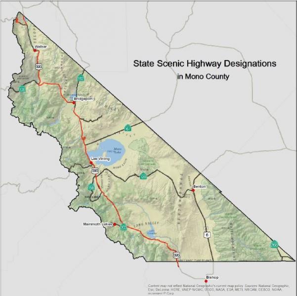
FIGURE 6: Designated County Scenic Highways
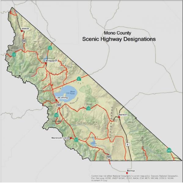
Town of Mammoth Lakes Transportation System
Road SystemThe major access into the town of Mammoth Lakes is provided by SR 203, which intersects with US 395, just east of the town limits. SR 203 (also named Main Street) is a four-lane road from US 395 through the majority of the developed portion of the town. SR 203 returns to two lanes north of the intersection of Main Street and Minaret Road. The highway continues from the developed area of the town to the Mammoth Mountain Ski Area, and terminates at the Mono-Madera county line. Portions of SR 203 are augmented by frontage roads. According to Caltrans' classification system, SR 203 is a minor arterial for the first 8.3 miles from US 395 through the town, and a minor collector for the westernmost 0.7 miles. Mammoth Scenic Loop, a two-lane road off SR 203, provides secondary access from the town to US 395 to the north. The Town's Road Network is shown in Figure 7.
ParkingParking in Mammoth Lakes is largely provided in private lots. In addition to the substantial parking lots provided at ski access portals, significant private parking facilities are provided at commercial centers. There is one park-and-ride lot located on the corner of Tavern and Old Mammoth; this lot is free, located adjacent to a transit stop, and can accommodate up to 100 cars. Existing parking lots in the town are well utilized during periods of peak visitor activity. The public has noted that traffic congestion in and around the town is caused in part by a shortage of accessible private and public parking. Mammoth Lakes is completing a Parking Study to evaluate existing conditions and estimate future demand. The study contains recommendations for parking control measures for the commercial portions of the town, including park-and-ride lots.
TransitThere are currently several public and private transit operations serving the Town:
Interregional Transit
The Eastern Sierra Transit Authority (ESTA) provides regional and long-distance service along US 395 from locations in the county to Lancaster and Reno. The southern portion of the route provides connections from Lancaster to Los Angeles and Kern counties, Metrolink, Amtrak, Greyhound and the Inyokern Airport. The northern portion of the route provides access to the Yosemite Area Regional Transportation System (YARTS), Reno-Tahoe International Airport, Amtrak, and Greyhound.
Mammoth Express
ESTA operates three round trips per day between Bishop and Mammoth, five days a week, with stops at Tom’s Place and Crowley Lake. This route is intended to serve commuters.
Mammoth Fixed Routes
ESTA now operates the year-round fixed route services in the town of Mammoth Lakes, and all winter routes previously operated by MMSA. MMSA contracts with ESTA to provide service to all winter ski portals, including capital replacement costs.
Dial-A-Ride (DAR) Services
ESTA provides DAR services in Mammoth. ADA paratransit services are available in Mammoth when DAR services are not available.
Reds Meadow Shuttle
ESTA contracts with the USFS to operate a shuttle from Mammoth Lakes to Reds Meadow and Devils Postpile during the summer months.
Mammoth Mountain - June Mountain Ski Area Winter Shuttle
ESTA operates a daily winter shuttle between Mammoth and June Lake, with two round trips per day.
Vanpool
ESTA has offered a vanpool program for commuters between Bishop and Mammoth, but it was suspended due to low ridership.
Yosemite Area Regional Transportation System (YARTS)
During the summer, YARTS provides service to and from Mammoth Lakes in Mono County (and locations in Mariposa and Merced counties) on a schedule that connects with the Yosemite National Park free shuttle service.
Lodging-based Shuttles
Condominiums and hotels in Mammoth Lakes and June Lake provide this service. These shuttles provide on-demand service to the Mammoth Yosemite Airport and to the ski areas for lodging guests.
Taxi Service
Limited taxi services are offered in Mammoth Lakes on a metered, demand-responsive basis.
Non-Motorized FacilitiesBiking, including organized bike races, has become an increasingly popular activity in and around the town. The General Bikeway Plan, updated in February 2014, provides a comprehensive plan for bicycle facilities, focusing on direct and convenient routing for the commuting cyclist. Figures 7A and 7B show existing and proposed bike paths in the town.
The Town of Mammoth Lakes Trail System Master Plan (MLTSMP) adopted in 2011 focuses on non-motorized facilities for alternative forms of transportation, including pedestrians, bicyclists, and Nordic skiers. The MLTSMP would connect and pass through a series of parks and open-space areas, having numerous access points in and around the town. Because of the significant existing and future traffic congestion in the town and the relatively compact development pattern, non-motorized facilities can be more than recreational facilities. A comprehensive trail system for pedestrian, cycling, and Nordic skiing will reduce auto travel, as well as provide important recreational amenities for visitors and community residents. Experience in similar resort communities has indicated a direct economic benefit from expansion of the trail system. Mammoth has already developed over several miles of multi-use paths, 80% of which have been funded with state and federal grant money.
In an effort to further develop an extensive pedestrian system, the Town adopted a comprehensive Pedestrian Master Plan in February 2014 (see Figures 7C and 7D).
AviationThe Mammoth Yosemite Airport is an important attribute to the community. Located eight miles east of the town, the airport is an FAA-certified commercial airport, currently offering charter services. The Mammoth Yosemite Airport is owned and operated by the Town of Mammoth Lakes. Scheduled commercial air service is currently available to northern and southern California (San Francisco, Los Angeles, San Diego) and Denver, CO, with routes varying seasonally.
The Mammoth Yosemite Airport provides an important link in the statewide aeronautics system. Pilots flying the Owens Valley-Long Valley corridor along the Eastern Sierra front find the airport to be a vital means of avoiding rapidly shifting weather conditions. The airport is subject to the Federal Aviation Regulations (FAR) Part 139, which sets standards for the operation and safety of airports with small commercial carriers. Under FAR Part 139, the Mammoth Yosemite Airport is required to have established procedure manuals, as well as crash, fire, and rescue equipment.
Additionally, there are helipads located around the town that are operated by the USFS and BLM (primarily for firefighting purposes), as well as a helipad at Mammoth Hospital that is used for air ambulance services.
The Town of Mammoth Lakes is currently updating the layout plan for the Mammoth Yosemite Airport; approval is expected from the FAA shortly. This plan provides for major development and expansion of the airport terminal area, including major infrastructure improvements, aircraft support facilities, and passenger terminal. The Mono County Airport Land Use Commission adopted a Comprehensive Land Use Plan (CLUP) for the Mammoth Yosemite Airport in 1998. The CLUP establishes specific land use policies to protect the public welfare and the safety of aircraft operations.
FIGURE 7: Town of Mammoth Lakes – Road Network
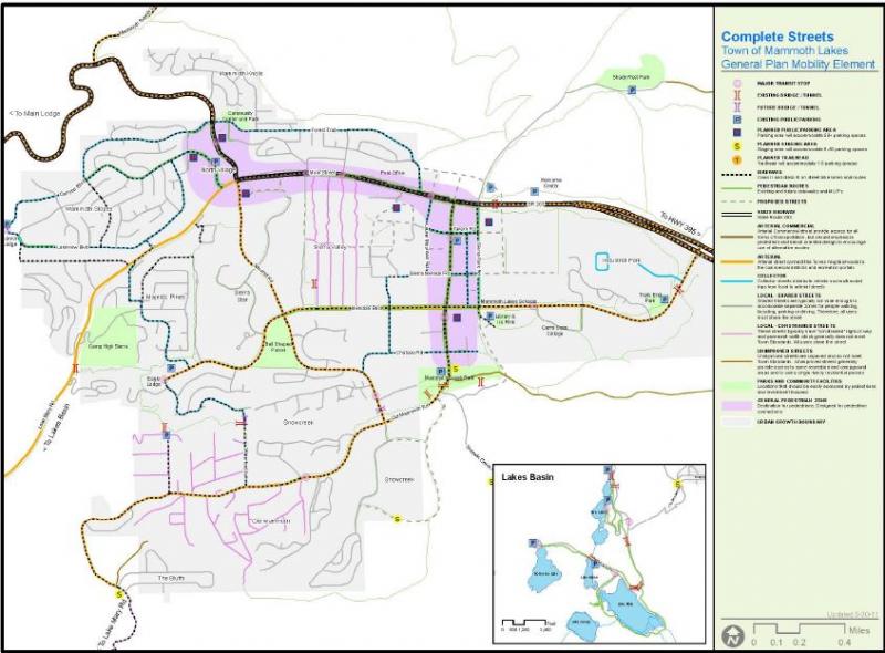
FIGURE 7A: Town of Mammoth Lakes – Bicycle Network
FIGURE 7B: Town of Mammoth lakes – Bicycle Network Detail
FIGURE 7C: Town of Mammoth Lakes – Pedestrian Network
FIGURE 7D: Town of Mammoth Lakes – Pedestrian Network Detail
- SR 203 (Main Street) experiences significant traffic congestion in Mammoth Lakes and between the town and Mammoth Mountain Ski Area during the winter months. This traffic congestion adversely impacts air quality due to auto emissions, diesel fumes from buses, and re-suspended road dust and cinders. Traffic congestion is also of concern during certain periods in the summer, both along arterial streets in the town, as well as between Mammoth Lakes, Reds Meadow and Devils Postpile.
- There continues to be a reliance on the private automobile. Parking availability is inadequate in commercial activity centers during periods of peak visitor activity, which exacerbates traffic congestion and generates illegal on-street parking that may hinder snow removal and internal circulation, as noted by the Town during snow-removal operations.
- The Mammoth Yosemite Airport's ability to offer expanded services (such as commercial scheduled air service) is limited due to inadequate facilities, runways, and aircraft ramps. The lack of infrastructure improvements reduces visitor air access to the region, which in turn maintains dependency on the automobile and perpetuates traffic problems in the community.
- Traffic congestion is expected to increase as a result of improvements to the Mammoth Mountain Ski Area as well as new growth areas/developments, including North Village, Sierra Star, and Snowcreek. Increased traffic, due to these expansions and new developments, will aggravate congestion and increase conflicts between vehicles and pedestrians. However, some of the Town's arterial roadways provide traffic capacity in excess of existing or forecast future needs, unnecessarily increasing their impact on the pedestrian/bicycle environment and the overall visual quality of the community.
Travel Demand, Town of Mammoth Lakes
Existing Travel DemandTravel demands in Mammoth Lakes are defined by resident activity as well as visitor activity. Year-round, the community's permanent population of roughly 7,500 generates travel demand patterns much like any other community of similar size, including employment trips, shopping trips, school trips, and recreational trips. In addition, the community's transportation network is impacted by the travel demand generated by visitors, which add up to roughly an additional 32,500 persons to the overnight population during the winter ski season. A summary of factors impacting existing travel demand is presented in Table 8.
Existing traffic volumes are depicted in the North Village Specific Plan Existing Plus Project Travel Impact Analysis (LSA Associates, Inc., Revised June 22, 2000). As shown, the highest traffic volumes in the community are found on Main Street between Minaret Road and Old Mammoth Road, with 15,900 to 16,400 vehicles per typical winter Saturday. The second-busiest street is Old Mammoth Road between Chateau Road and Main Street with 9,400 to 11,500 vehicles per typical winter Saturday. Traffic volumes on all other roadways are f than 10,000 vehicles per day.
TABLE 8: Factors Affecting Travel Demand in Mammoth Lakes
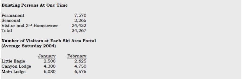
Existing traffic volumes are depicted in the Mammoth Lakes Transportation 2004, and 2024 [build-out year of the General Plan] Traffic Volume Results (LSC Transportation Consultants, December 7, 2004). As shown, the highest traffic volumes in the community are found on Main Street between Minaret Road and Old Mammoth Road, with 1,600 to 1,700 vehicles per hour on a typical winter Saturday. The second busiest street is Old Mammoth Road between Chateau Road and Main Street, with 1,250 to 960 vehicles per hour on a typical winter Saturday. Finally, the traffic volume along Minaret Road immediately north of Main Street is currently 1,090 vehicles per hour on a typical winter Saturday. Traffic volumes on all other roadways are less than 1,000 vehicles per hour.
Review of existing traffic conditions yields the following findings:
- Traffic activity varies substantially with season. Caltrans’ counts from the 2003-04 count season indicate that the average daily traffic on Main Street just east of Minaret Road in the peak summer month (August) of 12,688 vehicles per day slightly exceeds the peak winter month (February) volume of 12,617 vehicles per day. In comparison, the lowest monthly volume of 8,553 occurs in May and corresponds to only 67% of the traffic volume in the peak month.
- However, the average Saturday traffic volume along Main Street just east of Minaret Road in January and February was equal to 15,565 and 15,970 vehicles per day, respectively. These average winter Saturday traffic volumes are higher than the average daily traffic volumes occurring on any day throughout the week in the summer. This suggests that although overall traffic volumes are consistently higher during the summer months, winter Saturdays represent the period during which the highest traffic volumes occur.
- Reflecting historic patterns of ski area facilities and amenities, a substantial proportion of existing access to MMSA is provided via Minaret Road. This concentration of ski traffic (particularly at the end of the ski day) on a two-lane facility, with limited capacity, creates the town’s most significant recurring traffic congestion problem.
- On a peak winter day, the Mammoth Mountain Ski Area transit ridership equals approximately 14,200 passengers. This equates to approximately 6,400 skiers, assuming each skier makes one transit round trip per day and that 90% of the passengers are skiers. In addition, according to Mammoth Mountain Ski Area, during the 2003-04 ski season approximately 21,600 skiers visited the ski area on the peak day. Therefore, it is estimated that approximately 30% of the skiers access Mammoth Mountain Ski Area by public transit.
In addition to general growth in travel resulting from increases in population and visitation, travel demand in Mammoth Lakes will be impacted by the following planned development:
- Implementation of the North Village Specific Plan;
- Completion of development at Snowcreek;
- The Sierra Star project;
- Shady Rest; and
- The Airport Facility and Service Expansion project.
A number of smaller residential and lodging projects will also increase travel demand. As part of the North Village and Sierra Star projects, access to MMSA will be substantially modified, increasing the proportion of access that is provided by portals other than Main Lodge.
The traffic model update analyses, prepared by LSC, indicate that total peak winter Saturday person trips will increase from the current level of approximately 166,000 to approximately 295,000 at build-out of the General Plan. Considering shifts in travel mode, average winter day traffic volumes on Town roadways will generally increase as follows:
- Main Street between Minaret Road and Old Mammoth Road: 24% to 55% increase;
- Lake Mary Road between Canyon Boulevard and Kelley Road: 42% to 98% increase;
- Old Mammoth Road between Main Street and Meridian Boulevard: 22% to 41% increase;
- Minaret Road between Main Street and Meridian Boulevard: 91% to 202% increase;
- Minaret Road between Main Street and Forest Trail: 44% to 61% increase;
- Minaret Road immediately north of Forest Trail: 71% increase; and
- Meridian Boulevard between Old Mammoth Road and Minaret Road: 45% to 129% increase.
Transit
Existing Transit ServicesThe Eastern Sierra Transit Authority (ESTA) was formed through a Joint Powers Agreement (JPA) in October 2006 to replace Inyo-Mono Transit as the transit provider in the Eastern Sierra. Its members are Mono County, Inyo County, the Town of Mammoth Lakes, and the City of Bishop. As a transit operator, ESTA provides a variety of local and regional transit services, including demand-response, fixed-route, deviated fixed route, intercity connections to multiple communities in the Eastern Sierra, and regional service to Reno, NV, and Lancaster, CA.
ESTA provides transit services in Mono County and regionally. ESTA recently adopted the Inyo-Mono Counties Coordinated Public Transit-Human Services Transportation Plan Update (April 4, 2014). This document provides extensive information on existing transit services in the region, a transportation needs assessment for the region, and an implementation plan for providing coordinated services throughout the region. That plan is incorporated by reference in the RTP.
The following transit services are currently available in Mono County:
ESTA TRANSIT SERVICES
Interregional Transit
ESTA provides regional and long-distance service along US 395 from locations in the county to Lancaster and Reno. The southern portion of the route provides connections from Lancaster to Los Angeles and Kern counties, Metrolink, Amtrak, Greyhound and the Inyokern Airport. The northern portion of the route provides access to the Yosemite Area Regional Transportation System (YARTS), Reno-Tahoe International Airport, Amtrak and Greyhound.
Mammoth Express
ESTA operates three round trips per day between Bishop and Mammoth, five days a week, with stops at Tom’s Place and Crowley Lake. This route is intended to serve commuters.
Mammoth Fixed Routes
ESTA now operates the year-round fixed-route services in the town of Mammoth Lakes, and all winter routes previously operated by MMSA. MMSA contracts with ESTA to provide service to all winter ski portals, including capital replacement costs.
Dial-A-Ride (DAR) Services
DAR services are provided in Walker and Mammoth. ADA paratransit services are available in Mammoth when DAR services are not available.
Reds Meadow Shuttle
ESTA contracts with the USFS to operate a shuttle from Mammoth Lakes to Reds Meadow and Devils Postpile during the summer months.
Mammoth Mountain - June Mountain Ski Area Winter Shuttle
ESTA operates a daily winter shuttle between Mammoth Lakes and June Lake.
Vanpool
ESTA has offered a vanpool program for commuters between Bishop and Mammoth Lakes, but it was suspended due to low ridership.
OTHER TRANSPORTATION SERVICES
Yosemite Area Regional Transportation System (YARTS)
During the summer, YARTS provides service to and from Mammoth Lakes, June Lake and Lee Vining in Mono County (and locations in Mariposa and Merced counties) to Yosemite Valley, and more recently to Tuolumne Meadows as a high-country alternative to relieve congestion in Yosemite Valley, on a schedule that connects with the Yosemite National Park free shuttle service.
Lodging-based Shuttles
Condominiums and hotels in Mammoth Lakes and June Lake provide this service. These shuttles provide on-demand service to the Mammoth Yosemite Airport and to the ski areas for lodging guests.
Taxi Service
Limited taxi services are offered in Mammoth Lakes on a metered, demand-responsive basis.
Mono County Senior Services
Mono County Social Services runs the Senior Services program, and provides transportation services for seniors who cannot ride ESTA buses due to physical limitations. The agency takes seniors shopping, to the doctor, or to obtain other services, locally or long distance. Senior trips go to destinations such as AARP conventions, Reno, or Los Angeles. Senior Services runs a meals-on-wheels program and helps distribute government surplus food throughout the county.
Inyo-Mono Association for the Handicapped (IMAH)
IMAH provides respite care and adult day-care services for older adults and developmentally disabled residents. IMAH provides transportation for clients to and from programs as well as to work, using six vehicles it owns.
Toiyabe Indian Health Project
The Toiyabe Indian Health Project provides transportation for Native Americans and their families for shopping, medical and other necessary purposes. Based in Bishop, the project provides transportation in both Inyo and Mono counties.
School Buses
The county's dispersed population and the location of its public schools require some students to travel many miles to and from school. Both the Eastern Sierra Unified School District and the Mammoth Unified School District provide bus services for their students.
Charter Services
There are no other interregional transit services other than private charter lines. The majority of private charters originate in Southern California and less frequently from the Bay Area and Las Vegas. The majority of charter buses stop in Mammoth Lakes. According to the Mammoth Lakes Visitors Bureau, approximately 20 to 30 buses per day serve Mammoth Lakes in the summer months, averaging approximately 40 persons per bus, and approximately 10 to 15 buses arrive per day in the winter months, averaging 40 persons per bus.
Transit Dependent PopulationsTransit needs may be assessed in terms of those segments of the population that are dependent on some form of public transportation. In Mono County, these are generally young people, seniors, disabled persons, or low-income persons. Table 9 shows population projections for young people and seniors. The percentage of young people is projected to remain relatively stable over the next 20 years while the senior population is projected to rise approximately 100% over the next 20 years. The senior population often has mobility concerns that require specialized transportation.
The current Inyo-Mono Counties Coordinated Public Transit-Human Services Transportation Plan (2014) prepared for ESTA notes the following concerning transit-dependent populations in Mono County:
- The greatest number of persons over age 65 in Mono County lives in Mammoth Lakes (550);
- Mammoth also has the greatest number of persons living below the poverty level (1,058), as well as a high number of seasonal workers;
- There are 75 households without a vehicle in Mammoth and 53 in June Lake;
- Data on residents with disabilities is not yet available from the 2010 Census;
- Most employment in Mono County is within the tourism sector related to the ski resort, or to county government. Major employers in Mono County (more than 200 employees) include Mammoth Hospital, Mammoth Mountain Ski Area, and Mono County.
- In Mono County, the median household income is $60,469. Around 2.4% of households receive Supplemental Social Security, 1.2% received cash assistance, and 4.3% receive SNAP benefits;
- Nearly 40% of Mono County employed residents work in Mammoth Lakes. Another 11.3 work in Crowley Lake. Approximately 7% commute to Bishop and another 5.3% commute to Bridgeport. Almost 75% of employees working in Mammoth Lakes commute from elsewhere, largely Bishop, Crowley Lake, Chalfant and June Lake. There is a high level of commuting between Bishop and Mammoth Lakes, with a greater number of commuters traveling from Bishop to Mammoth Lakes.
- Population projections prepared by the California State Department of Finance forecast a very significant growth in older adults who will require access to medical and social services. The senior population (65+) is forecast to increase by 30% between 2010 and 2020, and by 20% between 2020 and 2030. Between 2020 and 2030, much of the increase will be in residents age 75+.
Transit issues and needs include the following:
- The Eastern Sierra Transit Authority Short-Range Transit Plan is incorporated as part of the Mono County RTP (see Chapter I, Planning Process). That plan provides greater detail concerning transit needs, facilities, and services in Mono County. The Mammoth Lakes Transit Plan is also incorporated as part of the Mono County RTP and provides greater detail concerning transit needs, facilities, and services in Mammoth Lakes.
- The Inyo-Mono Counties Coordinated Public Transit-Human Services Transportation Plan Update is incorporated by reference and provides great detail about transit needs, facilities, and services in Mono County and the Eastern Sierra. That plan identifies a number of issues and opportunities for the continuing provision of transit services in the Eastern Sierra, including:
- Coordination of existing services;
- Opportunities to increase coordination among service providers;
- Barriers to coordination (geographical, staffing, cost of fares, restrictions on the use of certain small vehicles owned and operated by social-services agencies, lack of funding);
- Opportunities to eliminate duplication of services, thereby maximizing limited transportation resources; and
- Opportunities to plug gaps in service identified by human service agencies in the area.
- The current principal method of transportation to and through Mono County is the highway system. Alternative methods of moving people and goods to and through the county are limited. There is no rail service. The existing airports, because of their high-altitude location and the often severe weather conditions in the area, are limited in the amount and type of service that they can accommodate.
- There is a continuing need for increased transit services to reduce congestion and related air quality impacts, particularly in Mammoth Lakes and potentially in June Lake.
- Transit-dependent populations in Mono County include young people, seniors, and low-income persons. Over the next 20 years, the population of young people is projected to remain relatively stable while the senior population is projected to increase significantly. Estimates show the number of persons living in poverty to be relatively stable. Although low-income persons traditionally are transit dependent, social-services providers indicate that they tend to be less so in Mono County where the need for a car is greater than in more urbanized areas.
- There are a significant number of commuters in Mono County, particularly between Mammoth Lakes and Bishop.
- The June Lake and the Bodie Hills area policies both encourage the development of transit shuttle services in their respective areas.
Non-Motorized Facilities
Non-motorized issues and needs include the following:
- The County completed a Trails Plan, including a General Bikeway Plan, in 1994 and updated both plans in 2015 (see Appendix G for the Trails Plan). These plans provide comprehensive planning for non-motorized facilities in the unincorporated areas.
- The overall purpose of the Mono County Trails Plan is to establish trail systems that facilitate multi-modal travel and recreation within, around and between unincorporated communities in the county. The plan addresses regional routes that provide access to communities throughout the county and to major recreational areas and existing trail systems, and community routes that provide access throughout communities and to surrounding recreational areas.
- The Trails Plan is intended to expand upon and implement policies in the Mono County General Plan, associated Area Plans, and the RTP, and to coordinate with the applicable plans of Federal land management agencies. The Plan focuses primarily on the development of facilities for recreational users, both residents and visitors, and conceptualizes the opportunity to create an Eastern Sierra Regional Trail system. This proposed system would provide a regional non-wilderness trail system close to 300 miles long in Inyo and Mono counties. Ninety percent of the system would be on existing trails, old railroad alignments, wagon roads, and abandoned roads; 10% of the system would require new construction. This project has been developed to a conceptual level and requires further development, including community and agency outreach to refine alignments, projects and programs.
- The Mammoth Lakes General Bikeway Plan (2014), Mammoth Lakes Pedestrian Master Plan (2014), Mammoth Lakes Trail System Master Plan (2011), and the Municipal Wayfinding Master Plan (2012) are incorporated as part of the Mono County RTP. Those documents provide comprehensive planning for non-motorized facilities in the town of Mammoth Lakes.
- There is a growing need for additional trail systems throughout the county, both within and between community areas. There is the potential to link existing trail systems, which are predominantly on public lands, to newly developed trail systems on private and county lands in community areas. State planning law (Section 65302 (e) et seq. of the Government Code) requires every city and county to consider a trail system in its open space element. The law also requires every city and county to consider the feasibility of integrating its trail system with appropriate segments of the state system.
- Most bicycle travel in the region now occurs on streets and highways without special bike facilities. This will probably be true in the future as well, particularly as commuting by bicycle increases in popularity in community areas. In some instances, some street systems may be fully adequate for safe and efficient bicycle travel, and signing and striping for bicycle use may be unnecessary. In other cases, signing and/or striping can serve as a means to alert motorists of the presence of bicyclists that may be using the roadway.
- In past RTPs and Circulation Elements, the Mono County LTC adopted the policy that the most important effort that could be undertaken to enhance bicycle travel would be improved maintenance of existing roads that are used regularly by bicyclists. This effort requires increased attention to the shoulder portion of roadways where bicyclists are expected to ride. Caltrans has indicated that it has put increased sweeping into its maintenance budget and has received good feedback.
- The consideration of bicycle needs in construction projects and in safety and operational improvements is also important. Through the Mono County Trails Plan the County road system has been reviewed to determine the immediate needs of bicyclists in terms of increasing safety for riders and requests by users for bicycle lanes. Many rural highways are used by touring bicyclists and locals for recreational travel and travel between communities. The development and maintenance of paved roadway shoulders with a wider 8-10 inch edge-line stripe would significantly improve the safety and capacity for bicyclists.
- In January 2000, the Mono County LTC voted to support the following requests from the Sierra Cycling Foundation for bike route signing in Mono County on state highways and county routes:
- US 395 north and south from Tom’s Place to SR 158;
- June Lake Loop (SR 158) in both directions;
- SR 120 to Benton in both directions;
- US 395 north of June Lake Junction to Lee Vining in both directions;
- SR 203 from US 395 to Mammoth Mountain Ski Area in both directions;
- Upper Rock Creek Road from Tom’s Place to Mosquito Flat in both directions;
- Lower Rock Creek Road from Tom’s Place to the Inyo County line in both directions;
- Benton Crossing Road to SR 120 in both directions;
- Crowley Lake Drive to Sherwin Creek Road in both directions; and
- Owens River Road in both directions.
- With the exception of Upper Rock Creek Road, all routes have been identified in the RTP and Mono County General Plan Circulation Element as Regional Bike Routes. Caltrans wants to ensure that bike route signage on state highways is coordinated with bike route signage on other county routes. They intend to install signs as soon as they verify that routes proposed for bike route signage are appropriate for bicycle usage.
- There is a need for improved and expanded pedestrian facilities in community areas throughout the county, both to improve safety and to increase access to commercial core areas in communities. Safe Routes to Schools routes can be developed in additional areas. The community issues section of this document identifies those areas where improved pedestrian facilities are needed, such as the June Lake Village. The Livable Communities planning process is developing planning principles, included in this RTP, to convert communities in the county to more walkable communities. The focus is on Crowley Lake, Lee Vining, June Lake, and Bridgeport.
- Active Transportation Program funding provides an opportunity to develop and fund coordinated systems for non-motorized users. There may be an opportunity to target some of the lower-income areas of communities, if they qualify as disadvantaged communities.
The unincorporated area of Mono County, outside of the town of Mammoth Lakes, has few existing dedicated bicycle facilities. The following section on bicycle needs in the unincorporated area of Mono County is an excerpt from the Mono County Bicycle Transportation Plan (Draft, 2014):
Existing Bicycle Routes and SignageAlthough cycling is an increasingly popular activity in Mono County, the County lacks facilities specifically for bicyclists. Most cycling occurs on roadways where the shoulder may or may not be wide enough to accommodate bicyclists safely. Mountain bike use occurs throughout the county on dirt roads, which generally are not marked as bike trails. The following are the sections of local roads with markings/signage for bike use:
- Bike Route along Crowley Lake Drive and South Landing Road from Tom’s Place to Crowley Lake;
- Bike Route along Pearson Road in Crowley Lake;
- North Shore Drive Bike Route in June Lake;
- Share the Road signs along Benton Crossing Road;
- Share the Road signs along SR 158 in June Lake;
- Bicycle/pedestrian bridge over the East Walker River in Bridgeport;
- Recently designated bike lane on Main Street (US 395) in Bridgeport; and
- Eastside Lane Bike Route in the Antelope Valley
It is the policy of the Local Transportation Commission that when rehabilitation work is planned for local/state highways, that non-motorized users be consulted for the addition of bike/pedestrian facilities prior to construction.
Existing Rest FacilitiesRest facilities (e.g., restrooms, drinking water, public phones, and air for tires) and parking facilities (for vehicles and bicycles) are available in most communities at the community center, private facilities in communities, schools, county parks, and USFS facilities. Caltrans maintains the Crestview Safety roadside Rest Area (US 395).
Outside of communities, rest facilities and parking facilities are available at USFS facilities (campgrounds and recreational areas), and at private recreational areas (e.g., Twin Lakes, Brown's Campground on Benton Crossing Road, etc.). There are few rest facilities on the many dirt roads in the county used by bicyclists. Most of those roads are on public lands and the applicable land management policy for those areas is generally to keep them as undeveloped recreational areas.
The Eastern Sierra Scenic Byway provides interpretive kiosks and some rest facilities along the length of US 395 in Mono County and along SR 120 between Yosemite National Park and US 395.
Existing Parking Facilities
Bike racks are located at the following locations:
- June Lake Library and Community Center;
- USFS Mono Basin Visitor Center in Lee Vining;
- Behind Mono Mart in LV for employees;
- County Annex building in BP;
- Lee Vining High School;
- Lee Vining Community Center; and
- Town of Mammoth Lakes in various locations
No facilities specifically exist for bicycle riders to change clothing (changing facilities) except for restrooms adjacent to the bike racks mentioned above.
Transport Facilities/Public Transit ConnectionsAll Eastern Sierra Transit buses have bike racks. The transit system recently installed shelters in various communities throughout the county; however, the shelters will not be equipped with bike racks.
Bus shelters have been installed at the following locations:
- Crowley Lake Drive, just north of Tom’s Place store;
- Community Center in Crowley Lake;
- Benton, US 6 in front of the school;
- Lee Vining, near the Mono Vista RV park and in front of the Caltrans Yard and on SR 120 at the Mobil Mart YARTS stop;
- Mono City, on US 395;
- Walker, US 395 southbound at Mule Deer Road and northbound across from Mule Deer Road;
- Coleville, US 395 southbound just south of the school;
- Bridgeport, on Emigrant Street next to the County Park tennis courts; and
- Town of Mammoth Lakes along Main Street and Meridian Boulevard
The unincorporated area of Mono County, outside the town of Mammoth Lakes, has few existing dedicated bicycle facilities. With job centers and school locations often outside their community, it is not practical for most people to commute to work on bicycles or for many students to commute to school using bicycles. Both students and workers must often drive many miles to their destination, to a community other than the one in which they reside. Extreme weather conditions also make it difficult to bike year round; snow and ice in many parts of the county limit winter biking opportunities, while extreme heat and dust storms decrease summer biking opportunities in a few other areas.
There is growing interest in commuting by bicycle within communities. Generally, traffic congestion is limited, and air quality impacts from automobile use are minimal in the county. Most Mono County communities are small, with relatively flat topography.
The 2009-13 American Community Survey indicated 2.5% of workers ride bicycles to work, and 14% walk.
Recreational Use/Bicycling EventsRecreational biking is an increasing tourist attraction in the county, both on county roads and highways and on unpaved roads on public lands. Opportunities for recreational bicycling are abundant. Many of the County’s paved roads have little traffic and lead to a variety of scenic recreational destinations. The local cycling community currently produces several large-scale bike events on roads within the county (the High Sierra Fall Century/Gran Fondo, Everest Challenge, Pamper Pedal, and several others). The Sierra Cycling Foundation/Eastside Velo has indicated that organizers would like to attract more large-scale biking events to the county.
Safety and Education ProgramsSeveral entities within Mono County conduct bicycle safety and educational programs.
- The Mono County Health Department sponsors bicycle safety activities throughout the year in conjunction with other County and Town agencies. A limited number of bicycle helmets are available for children whose families cannot afford to buy one.
- The Mammoth Lakes Police Department has an ongoing program of bicycle safety and education primarily oriented toward elementary school-aged children. The program includes a yearly “Bicycle Rodeo” for all grades, bicycle inspection, bicycle safety handouts, and bicycle registration. The Bicycle Rodeo focuses on riding safety and instruction, helmet use, traffic-sign recognition, bicycle lane use, handling crosswalks, hand signals, etc. Bicycles are checked for safety features such as seats, handlebars, brakes, and tires; a special sticker is issued validating inspection. The program is conducted on a yearly basis. Safety handouts are also available for younger children in the first and second grades.
- Sierra Cycling Foundation’s mission is to promote cycling and improve cycling conditions in the Eastern Sierra. The group advocates bicycle safety and education of cyclists as well as motor-vehicle operators, strongly supports the “share the road” concept, and continually strives to add more miles of “share the road” signs. Eastside Velo provides bicycle safety information and suggested routes and rides for cyclists visiting and living in the Eastern Sierra and emphasizes bicycle-safety training for children, mandatory helmet laws, and safer road conditions by working with public works and planning departments in Inyo and Mono counties, the Town of Mammoth Lakes, the City of Bishop, Eastside Velo and Caltrans, District 9.
The Caltrans Highway Design Manual identifies four types of bicycle facilities:
- Shared Roadway (No bikeway designation).
- Class I Bikeway (Bike path). Separate right of way for bicyclists. Generally should serve corridors not served by streets or highways.
- Class II Bikeway (Bike lane). Utilizes the shoulder area of roads. Signing and striping separate areas for bicyclists and motorists.
- Class III Bikeway (Bike route). Similar to a Class II Bikeway, except that the shoulder area is shared with vehicles.
Most of the facilities in the county are Shared Roadways. There is a short Class II Bikeway along Crowley Lake Drive in the vicinity of Aspen Springs as well as in downtown Bridgeport. There are also marked mountain bike routes on dirt roads in the western end of Long Valley. Caltrans District 9 generally pursues 8-foot shoulders on highways when feasible for safety, which also facilitiates bike use, and has initiated a District 9 multi-modal plan to provide additional direction for District 9 facilities.
Selection of the appropriate type of bikeway to meet an identified need is dependent on many factors, including safety, demand, and connection to other bike facilities. The Caltrans Highway Design Manual contains criteria to help determine whether designation of a bikeway is appropriate and, if so, which type is most suitable. The relative cost of various types of facilities is also a consideration.
In Mono County, shared roadways (with a 4-foot paved shoulder and 8- to 10-inch edge stripe) will continue to be the most feasible type of bikeway in most areas. Relatively low bicycle demand may make it infeasible to designate bikeways; environmental considerations and maintenance costs may make it difficult to develop separate bike paths.
The Bicycle Transportation Plan contains a list of overall needs related to biking in unincorporated Mono County, which was developed by local bicycling groups, along with lists of specific needs for community areas.
Town of Mammoth Lakes – Non-Motorized FacilitiesIn Mammoth Lakes, non-motorized facilities for the use of pedestrians, bicyclists, equestrians and Nordic skiers have been comprehensively planned. Because of the significant existing and future traffic congestion in Mammoth Lakes, non-motorized facilities can be more than recreational facilities. A comprehensive system of walking, bicycle and Nordic trails will reduce auto travel and provide important visual and activity amenities for visitors and community residents. The Town continues to implement its plans for non-motorized facilities by improving and linking additional portions of its trails system.
Active Transportation ProgramThe Active Transportation Program (ATP) was created by Senate Bill 99 (Chapter 359, Statutes 2013) and Assembly Bill 101 (Chapter 354, Statutes 2013) to encourage increased use of active transportation modes, such as biking and walking. The goals of the Active Transportation Program are to:
- Increase the proportion of trips accomplished by biking and walking;
- Increase the safety and mobility of non-motorized users;
- Advance the active transportation efforts of regional agencies to achieve mandated greenhouse gas reduction goals;
- Enhance public health, including reduction of childhood obesity through the use of programs including, but not limited to, projects eligible for Safe Routes to School Program funding;
- Ensure that disadvantaged communities fully share in the benefits of the program; and
- Provide a broad spectrum of projects to benefit many types of active transportation users.
Ten percent of all ATP funding is awarded to small urban and rural areas with populations of 200,000 or less. Twenty-five percent of the funding in this category must benefit disadvantaged communities. Another 50% of all ATP funding is awarded competitively on a statewide basis. Twenty-five percent of the funding in that category must benefit disadvantaged communities as well.
Funding is available for a variety of project types, including infrastructure and non-infrastructure projects, e.g.:
- Development of new bikeways and walkways that improve mobility, access, or safety for non-motorized users;
- Improvements to existing bikeways and walkways, which improve mobility, access, or safety for non-motorized users;
- Elimination of hazardous conditions on existing bikeways and walkways;
- Preventative maintenance of bikeways and walkways with the primary goal of extending the service life of the facility;
- Installation of traffic-control devices to improve the safety of pedestrians and bicyclists;
- Safe Routes to School projects that improve the safety of children walking and bicycling to school;
- Safe routes to transit projects, which will encourage transit by improving biking and walking routes to mass transportation facilities and school bus stops;
- Secure bicycle parking at employment centers, park-and-ride lots, rail and transit stations;
- Bicycle-carrying facilities on public transit;
- Establishment or expansion of a bike-share program;
- Recreational trails and trailheads, park projects that facilitate trail linkages or connectivity to non-motorized corridors, and conversion of abandoned railroad corridors to trails;
- Education programs to increase bicycling and walking, and other non-infrastructure investments that demonstrate effectiveness in increasing active transportation;
- Development and publishing of community walking and biking maps, including school route/travel plans;
- Components of open-streets events directly linked to the promotion of a new infrastructure project; and
- Development of a bike, pedestrian or active transportation plan.
A portion of Active Transportation Program funding must go to Disadvantaged Communities. For a project to contribute toward the Disadvantaged Communities funding requirement, the project must clearly demonstrate a benefit to a community that meets any of the following criteria:
- The median household income is less than 80% of the statewide average based on census tract level data from the American Community Survey;
- An area identified as among the most disadvantaged 10% in the state according to latest versions of the California Communities Environmental Health Screening Tool (CalEnviroScreen) scores; or
- At least 75% of public school students in the project area are eligible to receive free or reduced-price meals under the National School Lunch Program. Applicants using this measure must indicate how the project benefits the school students in the project area or, for projects not directly benefiting school students, explain why this measure is representative of the larger community.
If a project applicant believes a project benefits a disadvantaged community but the project does not meet the criteria identified above, the applicant may submit a quantitative assessment of why the community should be considered disadvantaged. There are currently no communities in Mono County that meet the criteria for qualification as a disadvantaged community. Standardized state data often do not capture Mono County’s small, rural communities well.
Aviation
Three public airports are located in Mono County: Mammoth Yosemite Airport, Lee Vining Airport, and Bryant Field (Bridgeport Airport). In addition to the airports, there are several helipads located throughout the county. The following information on airports in the county is from the California Aviation System Plan (CASP), 2013 Inventory Element.
Mammoth Yosemite AirportMammoth Yosemite Airport, located eight miles east of Mammoth Lakes, is an FAA-certified commercial airport offering charter services. It is owned and operated by the Town of Mammoth Lakes. The airport provides convenient access for recreation, tourism, and charter services, as well as emergency access for medical and firefighting activities. Mammoth Yosemite Airport has 130 hangars and 80 tie-downs. Eight single-engine planes and two multi-engine planes were based there in 2012.
In 2012, the airport reported 8,000 aircraft operations, with 26,196 enplanements and 39,596 total passengers. Of the 8,000 aircraft operations, 129 were air carriers, 1,759 were air taxis, 2,048 were general aviation local flights, 4,029 were general aviation itinerant flights, and 35 were military flights. Total passenger traffic (combined passenger counts reflecting both enplaned and deplaned counts) rose from 53,541 in 2011 to 54,386 in 2012.
The Mammoth Yosemite Airport provides an important link in the statewide aeronautics system. Pilots flying the Owens Valley-Long Valley corridor along the Eastern Sierra front find the airport to be a vital means of avoiding rapidly shifting weather conditions. The airport is subject to the Federal Aviation Regulations (FAR) Part 139, which sets standards for the operation and safety of airports with small commercial carriers. Under FAR Part 139, the Mammoth Yosemite Airport is required to have procedure manuals, as well as crash, fire, and rescue equipment.
Limited year-round commercial air service is available to Southern California, and more direct flights are available in the winter.[1] That service is subsidized by Mono County, the Town of Mammoth Lakes, and Mammoth Mountain Ski Area. The Town of Mammoth Lakes has formed a public/private partnership with Mammoth Mountain Ski Area (MMSA) to develop the airport. The Town is developing the airport, including widening and lengthening the runway and taxiways, airline ramps, a new terminal, and other safety improvements. MMSA is providing a revenue guarantee for commercial airline service into the airport. The short-term capital improvement program for Mammoth Yosemite Airport, including improvements and maintenance projects, is included in Chapter 5, Action Element.
Lee Vining AirportLee Vining Airport, located in Lee Vining, is designated as a "Limited Use-Recreational Access" facility serving the general aviation public. It is owned and operated by Mono County. The airport provides convenient access for recreation and tourism, as well as emergency access for medical activities.
The airport has three hangars and seven tie-downs; currently no aircraft are based there. The airport has a pilot-activated lighting system and a navigational beacon but no aviation fuel is available. The airport is located at an elevation of 6,802 feet. In 2012, the airport reported 2000 aircraft operations; all 2000 were general aviation itinerant flights.
Recent improvements at the airport included replacing the runway with a properly graded one that is 4,940 feet long and 60 feet wide and installing paved overruns at both ends of the runway. Future improvements include a full-length parallel taxiway, lighting enhancements, perimeter fencing and a card access control gate, and an automatic weather observation system. The short-term capital improvement program for Lee Vining Airport, including improvements and maintenance projects, is included in Chapter 5, Action Element.
Bryant Field (Bridgeport)Bryant Field, located in Bridgeport, is designated as a "Community – Recreational Access" facility serving the general aviation public. It is owned and operated by Mono County. The airport provides convenient access for business and tourism, as well as emergency access for medical and firefighting activities.
The airport has no hangars and 18 tie-downs; currently no aircraft are based there. The airport has a pilot-activated lighting system, a navigational beacon, and aviation fuel available. The airport is located at an elevation of 6,468 feet. The existing runway is 4,239 feet long and 60 feet wide. A parallel taxiway serves about 2/3 of the runway length; extension of the taxiway is limited by the proximity of Bridgeport Reservoir. In 2012, the airport reported 500 aircraft operations; 200 were general aviation local flights, 300 were general aviation itinerant flights. On occasion, the Marine Corps Mountain Warfare Training Center requests special permission to use the airport for training exercises.
Relatively recent safety improvements at the airport include lighted runway distance signs, lighted airport signs, Runway End Identifier Lights (REIL) on runway 34, Precision Approach Path Indicators (PAPI) on Runway 34, lighting vault renovations, and an Automatic Weather Observation System (Superawos). The short-term capital improvement program for Bryant Field, including improvements and maintenance projects, is included in Chapter 5, Action Element.
Helipads
In addition to the airports, there are several helipads in the county. One is operated by the U.S. Marine Corps at its Mountain Warfare Training Center at Pickel Meadow. Others are operated by the USFS and BLM, primarily for firefighting purposes. Helipads located at Mammoth Hospital in Mammoth and at Mono Medical Center in Bridgeport are used for air ambulance services.
Airport Planning Documents
Airport Master Plans guide the future growth and development of an airport and identify improvements needed to respond to aviation demand over a 20-year time frame. Master Plans and Airport Layout Plans were last revised for Bryant Field and the Lee Vining Airport in 2006, and for Mammoth Yosemite Airport in 2000.
Comprehensive Land Use Plans (CLUPs) are adopted by the Airport Land Use Commission (ALUC). These plans have two primary purposes: 1) to provide for the orderly growth of each public use airport and the area surrounding the airport within the jurisdiction of the ALUC, and 2) to safeguard the general welfare of the public within the vicinity of the airport. CLUPs were adopted for Bryant Field and the Lee Vining Airport in June 2006, and for the Mammoth Yosemite Airport in October 1998.
Aviation Forecasts and TrendsAircraft activity in Mono County is primarily general aviation activity; i.e., aircraft used for firefighting, emergency services, charter service, business or recreational use. As shown in Tables 10 and 11, general aviation aircraft activity will continue to play an important role in Mono County and the Eastern Sierra region. Aviation services and the existing airport infrastructure are necessary for the movement of people and light cargo, firefighting, and emergency medical purposes. For visitors, the air services provide the only alternate mode of transportation into Mono County (other than driving). For residents, air services permit rapid communication with business, governmental and medical centers throughout other areas of the state and rapid emergency medical transportation when necessary.
Although Mammoth Yosemite Airport is an FAA-certified commercial service airport providing charter service, plans are in the works to develop the facility for regularly scheduled passenger service. Mammoth Yosemite Airport is also the only airport in Mono County that provides air cargo service.
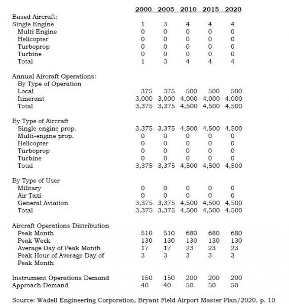
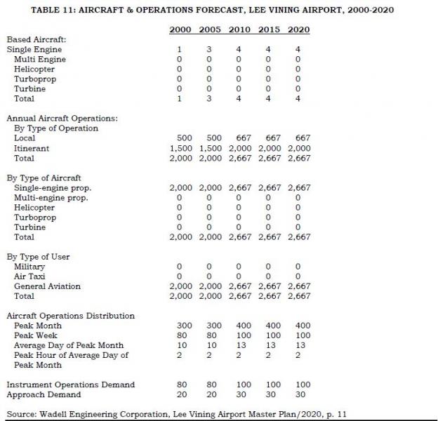
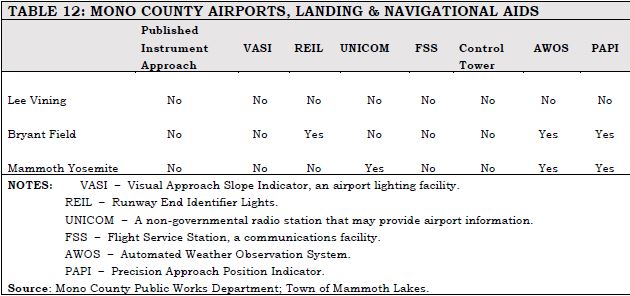
Aviation issues and needs include the following:
- No transportation terminals in the county exist aside from the terminal at the Mammoth Yosemite Airport. Use of that facility is discussed in the Mammoth Yosemite Comprehensive Land Use Plan (CLUP) and the Airport Master Plan. The three airports in the county are important for both residents and visitors. For visitors, the air services provide the only alternate mode of transportation into Mono County. For residents, the air service permits rapid communication with governmental, business, and medical centers in the western part of the state and rapid emergency medical transportation when necessary.
- Land use at all airports in the county is governed by the Airport Land Use Commission (ALUC). The Commission has adopted Comprehensive Land Use Plans (CLUPs) for the airports in the county.
- Expansion of commercial airline service, general aviation operations, and transit connections is considered to be an integral element in alleviating surface transportation problems in the town of Mammoth Lakes. Continued improvement of the Mammoth Yosemite Airport facilities and creation of revenue-generating airport businesses will be necessary before the airport can assume its full role in expanding air transportation services.
- The Town of Mammoth Lakes has formed a public private partnership with Mammoth Mountain Ski Area (MMSA) and Mammoth Lakes Tourism (MLT) to bring commercial air service to the community. The Town operates the airport and provides facilities and equipment that support commercial air service. The Town also seeks funding from the Federal Aviation Administration and other entities to fund capital improvements at the airport. MMSA and MLT secure revenue guarantee contracts with airlines that bring air service to the airport by guaranteeing the airline a minimum return on investment. Without these contracts, air service would not be possible in our area. Currently, the Town is working with the FAA to construct a new terminal building at the airport. A new terminal facility will enhance the ability of the Town and its partners to attract air carriers from a verity of markets. It is expected that the new terminal building and associated ramp and infrastructure will cost approximately $32 million with the FAA picking up approximately 90% of the cost.
- The California Aviation System Plan (CASP) identifies all the airports in the county as ones considered to be the Eastern Sierra’s highest priority facilities in terms of system capacity and safety enhancement. The CASP suggests needed safety improvements at all of the county’s airports.
- Operational and safety improvements are planned at Bryant Field and the Lee Vining Airport; the short-term capital improvement programs for Bryant Field and the Lee Vining Airport include these operational and safety improvements (see Chapter 5, Action Element).
Sustainable Communities Strategy
Metropolitan Planning Organizations (MPOs) are required to incorporate a Sustainable Communities Strategy (SCS) into their RTP in order to provide a process for meeting emissions-reducing goals for each region. The SCS is meant to integrate land use and transportation planning, programs, and projects as a means of reducing greenhouse gas emissions (GHGs). An SCS follows smart-growth planning concepts that seek to integrate development with housing and transportation near jobs, shopping, and schools.
The SCS focuses on the following areas:
- Identifying the general location of uses, residential densities, and building intensities within the region;
- Identifying areas within the region sufficient to house all the population of the region, including all economic segments of the population over the course of the planning period of the regional transportation plan taking into account net migration into the region, population growth, household formation and employment growth;
- Identifying areas within the region sufficient to house an eight-year projection of the regional housing need for the region;
- Identifying a transportation network to service the transportation needs of the region;
- Considering the best practically available scientific information regarding resource areas and farmland in the region;
- Considering the state housing goals;
- Utilizing the most-recent planning assumptions, considering local general plans and other factors;
- Establishing forecasted development patterns for the region, which, when integrated with the transportation network and otachieve, if there is a feasible way to do so, the greenhouse gas emission reduction targets;
- Providing consistency between the development pattern and allocation of housing units within the region; and
- Allowing the regional transportation plan to comply with Section 176 of the federal Clean Air Act.her transportation measures and policies, will reduce the greenhouse gas emissions from automobiles and light trucks to
Mono County, since it is not an MPO, is not required to develop and implement an SCS as part of the RTP. However, the County has taken a proactive stance toward achieving reductions in GHG emissions. Due to the unique physical and land ownership characteristics of land throughout the county, the County has long sought to integrate development within existing communities and to work with the existing transportation system. Mono County and the Town of Mammoth Lakes continue to proactively focus on providing for additional growth within existing communities and on developing a multi-modal transportation system that serves the needs of residents and visitors while at the same time protecting natural resources and reducing greenhouse gas emissions.
The topics to be addressed in an SCS are currently addressed either in the general plans for Mono County and the Town of Mammoth Lakes, or in the Resource Efficiency Plan, discussed previously in this Section. In addition, the County has other plans that support efficient regional development including the draft Mono County Regional Blueprint (Appendix F) and the Eastern Sierra Landownership Adjustment Project. The draft Mono County Regional Blueprint is a collaborative planning process that addresses regional growth management and a coordinated approach to transportation planning. The Blueprint includes a long-range vision, guiding principles, and an implementation strategy that are consistent with the Mono County and Town of Mammoth Lakes general plans and that can be implemented through the general plans. It focuses on providing a “safe, convenient and efficient multi-modal transportation system that enhances regional connectivity and community mobility.”
The Eastern Sierra Landownership Adjustment Project (LAP) notes that “the communities in the Eastern Sierra are uniquely protected from over-development even as they are sometimes constrained from logical and sustainable growth,” due largely to the lack of privately owned land. The Vision Statement of the LAP focuses on providing a regional growth strategy:
“Federal and state agencies, Inyo and Mono counties, local tribes, interested citizens, organizations, and private landowners will collaborate to explore and develop options to create a landownership pattern in the Eastern Sierra that better complements collaborative regional goals while preserving private property rights – focusing on opportunities to concentrate development around existing communities and infrastructure; provide workforce housing; maintain agricultural opportunities; protect water and other natural resources and open space; and consolidate agency lands.”
These planning efforts are directly compatible with the California Transportation Plan (CTP) 2040 update currently under way. The CTP is a statewide, long-range transportation plan to meet our future mobility needs and reduce greenhouse gas (GHG) emissions, and was initiated in conjunction with the California Interregional Blueprint. The CTP’s Vision is based on sustainability:
California's transportation system is safe, sustainable, universally accessible, and globally competitive. It provides reliable and efficient mobility for people, goods, and services, while meeting the State's greenhouse gas emission reduction goals and preserving the unique character of California's communities.
The Vision is supported by six goals:
- Improve multi-modal mobility and accessibility for all people;
- Preserve the multi-modal transportation system;
- Support a vibrant economy;
- Improve public safety and security;
- Foster livable and healthy communities and promote social equity; and
- Practice environmental stewardship.
[1] 2014-2015 flights included San Francisco and San Diego in California; Las Vegas, Nevada; and Denver, Colorado.
[1] See Addressing Climate change Adaptation in Regional Transportation Plans, pages 80-84, http://www.dot.ca.gov/hq/tpp/offices/orip/climate_change/documents/FR3_C.... February 2013.
[2] Original source document: Bodie Hills Multi-modal Plan (date).
[3] Original source document: Mono Basin Multi-modal plan (date).
[4] Original source document: June Lake Multi-modal Plan (date).
[1]Via searches on the American Fact Finder (U.S. Census website) at http://factfinder.census.gov/faces/nav/jsf/pages/index.xhtml and at http://factfinder.census.gov/faces/tableservices/jsf/pages/productview.x...
[2] 2014-2015 Mammoth Lakes PM10 and Meteorological Summary, Great Basin Unified Air Pollution Control District. http://www.townofmammothlakes.ca.gov/DocumentCenter/View/5292, cited May 13, 2015.
Overview
"The purpose of the Policy Element is to address legislative, planning, financial, and institutional issues and requirements, as well as any areas of regional consensus. The Policy Element presents guidance to decision-makers of the implications, impacts, opportunities, and foreclosed options that will result from implementation of the RTP. Moreover, the Policy Element is a resource for providing input and promoting consistency of action among state, regional and local agencies including: transit agencies, congestion management agencies, employment development departments, the California Highway Patrol, private and public groups, tribal governments, etc."
Regional Transportation Plan Guidelines, 2010, p. 93
The Policy Element is required to: 1) describe the transportation issues in the region; 2) identify and quantify regional needs expressed within both short-term (0-10 years) and long-term (10-20 years) planning horizons; and 3) maintain internal consistency with the Financial Element and fund estimates [California Government Code 65080 (b)]. The Policy Element should also describe how policies were developed, identify any significant changes in policies from previous plans, and provide the reasons for those changes.
Transportation issues and regional needs are described in Chapter 2, Needs Assessment. Policies for the Mono County RTP are based on the issues and needs identified in Chapter 2. As described in Chapter 1, Planning Process, the development and updating of the RTP includes ongoing public participation.
The focus of this Policy Element remains the same as in previous RTPs; maintaining existing streets and highways and developing additional transit and non-motorized facilities. The Policy Element should clearly convey the transportation policies of the region. As part of this Element, the discussion should: 1) relay how these policies were developed; 2) identify any significant changes in the policies from the previous plans; and 3) provide the reasons for any changes in policies from previous plans
This section contains regionally oriented transportation policies for Mono County. They are presented in the following format [as required by California Government Code 65080 (b)]:
Goals: End results toward which effort is directed. They are expressed in general terms and are timeless.
Policies: Direction statements that guide future decisions with specific actions.
Objectives: Results to be achieved by an identified point in time. They are capable of being quantified and realistically attained considering probable funding and political constraints. Objectives must be linked to short-range and long-range transportation implementation goals or horizons.
The policies address the following topic areas:
Land Use Issues Transit
Economic Factors Parking
Resource Efficiency Livable Communities
Environmental Issues Aviation
Operational Improvements Plan Consistency
Non-Motorized Transportation Community and Industry Consensus Development
Land Use Issues
GOAL 1. Correlate development of the transportation and circulation system with land use development.
Policy 1.A. Plan and implement a transportation and circulation system that is consistent with the land use, housing, and circulation policies in the Mono County General Plan.
Objective 1.A.1: Evaluate the RTP to ensure consistency with Mono County General Plan policies.
Time frame: Ongoing over the 20-year time frame of this plan; implement every four years with update of RTP.
Objective 1.A.2: Amend these policies as necessary to ensure consistency between the RTP and Mono County General Plan policies.
Time frame: Ongoing over the 20-year time frame of this plan; implement every four years with update of RTP.
Policy 1.B. Plan and implement a transportation and circulation system to provide, but not substantially exceed, the capacities needed to serve the long-range travel demand of residents and visitors.
Objective 1.B.1. Periodically update the long-range regional travel demand by assessing changes in land use, housing and projected demographic changes, conducting travel surveys throughout the county and traffic counts on County roads, and by incorporating data from Caltrans' traffic monitoring system and traffic census program (e.g., Average Daily Traffic (ADT) volumes for state highways).
Time frame: Ongoing over the 20-year time frame of this plan; implement every four years with update of RTP.
Objective 1.B.2. Implement a biennial traffic counting program on County roads.
Time frame: Continue biennial counts over the 20-year time frame of this plan.
Objective 1.B.3. Continue to collaborate with Caltrans in its 10-year origin and destination.
Time frame: Continue every decade.
Policy 1.C. Plan and implement a transportation and circulation system that supports the county Land Use objectives of concentrating development in community areas.
Objective 1.C.1. Accommodate future circulation and transit demand by using existing facilities more efficiently, or improving and expanding them before building new facilities
Objective 1.C.2. As transportation funding and maintenance dollars continues to be flat (or negative), consider providing a larger portion of discretionary funding toward maintaining and fixing current transportation infrastructure (fix it first).
Time frame: Ongoing over the 20-year time frame of this plan; review compliance every four years with update of RTP; review funding with current STIP Transportation Improvement Program cycle.
Policy 1.D. Plan and implement a transportation and circulation system that supports the county Land Use objectives of maintaining and enhancing local economies.
Objective 1.D.1. Avoid highway bypass of communities; instead, work to develop livable communities in those communities where the highway is Main Street while recognizing interregional concerns and functional classification constraints where they exist.
Time frame: Ongoing over the 20-year time frame of this plan.
Policy 1.E. Future land use/development projects with the potential to significantly impact the transportation system shall assess the potential impact(s) prior to project approval. Examples of potential significant impacts include:
- causing an increase in traffic that is substantial in relation to the existing traffic load and capacity of the street system; and/or
- disrupting or dividing the physical arrangement of an established community.
The analysis shall:
- be funded by the applicant;
- be prepared by a qualified person under the direction of Mono County;
- assess the existing traffic and circulation conditions in the general project vicinity;
- describe the traffic generation potential of the proposed project both on site and off site; and
- recommend mitigation measures to avoid or mitigate the identified impacts, both on site and off site.
Mitigation measures and associated monitoring programs shall be included in the project plans and specifications and shall be made a condition of approval for the project. Projects having significant adverse impacts on the transportation system may be approved only if a statement of overriding considerations is made through the EIR process. Traffic impact mitigation measures may include, but are not limited to, off-site operational improvements, transit improvements, or contributions to a transit fund or road improvement fund.
Policy 1.F. Require new development, when determined to be necessary by the Public Works director and found to be consistent with application laws by County Counsel, to provide dedications for improvements such as bicycle and pedestrian paths, transit facilities, snow-storage areas, and rights of way for future public roads identified in the Circulation Element, in conformance with the Subdivision Map Act (Government Code Section 66475 et seq.).
Objective 1.F.1. Amend County Code Section 17.36.100 to conform to Policy 6. Until such time as the County Code is amended, Policy 6 shall supersede Mono County Code Section 17.36.100. The County is amending its Subdivision Ordinance (Chapter 17 of the Mono County Code).
Time frame: Within two years.
Objective 1.F.2. Require new specific plans to contain a detailed plan, including financing arrangements, for local roadway and transit improvements (as applicable).
Time frame: Ongoing over the 20-year time frame of this plan.
Economic Factors
GOAL 2. Plan and implement a transportation and circulation system that is responsive to the County’s economic needs and fiscal constraints and that maintains the economic integrity of the county’s communities.
Policy 2.A. Continue to develop and implement public/private partnerships for the development, operation, and maintenance of transportation improvements in the county.
Objective 2.A.1. Seek partnership opportunities for the following projects:
- Improvements to Mammoth Yosemite Airport;
- Countywide bicycle and pedestrian trail development;
- Pedestrian improvements in community areas;
- Scenic Byway implementation;
- Transportation options/improvements to Bodie State Historic Park,
- Eastern Sierra Transit System, YARTS, and other transportation projects as applicable.
Time frame: Within the 10-year short-term time frame of this plan.
Policy 2.B. Maintain existing public/private partnerships and seek ways of expanding those partnerships.
Objective 2.B.1. Maintain the partnership between the Town and Mammoth Mountain Ski Area for airport development. Seek other possible partners for that project.
Time frame: Ongoing over the 10-year short-term time frame of this plan.
Policy 2.C. Enhancement of the county’s tourism and outdoor recreation-based economy shall be a high priority in planning and developing transportation improvements for the county.
Objective 2.C.1 Continue to participate in the Yosemite Area Regional Transportation System (YARTS).
Time frame: Ongoing over the 20-year time frame of this plan.
Objective 2.C.2. Develop bicycle, pedestrian, parking, and transit facilities that enhance accessibility to and around community areas.
Time frame: See policies for non-motorized facilities later in this chapter.
Policy 2.D. Ensure that new development, and related transportation system improvements, occurs only when a funding mechanism is available for the improvements needed to achieve and maintain specified modes and levels of service.
Objective 2.D.1. Require new development, where applicable, to fund related transportation improvements as a condition of project approval. Under Government Code Section 53077, such developer exactions shall not exceed the cost of the benefit.
Time frame: Ongoing over the 20-year time frame of this plan; implement at time of project approval.
Policy 2.E. Ensure that those benefiting from transportation improvements pay for those improvements.
Objective 2.E.1. Prioritize funding responsibility for transportation system improvements as follows:
Improvements that serve countywide traffic demand = state & federal funding improvements that serve local area demand = local funding (public & private)
Time frame: Ongoing over the 20-year time frame of this plan; implement at time of project approval.
Resource Efficiency
GOAL 3. Plan and implement a resource-efficient transportation and circulation system that supports sustainable development within the county.
Note: This section incorporates goals and policies presented in the draft Resource Efficiency Plan developed for Mono County. Many of these policies are already being implemented by Mono County and the Town of Mammoth Lakes but are included here as well to provide a comprehensive policy statement on resource-efficient planning and development. The Resource Efficiency Plan serves as Mono County’s response to meeting state requirements for a Sustainable Communities Strategy and reducing greenhouse gas emissions.Policy 3.A. Reduce greenhouse gas (GHG) emissions through local land use and development decisions, and collaborate with local, state, and regional organizations to promote sustainable development.
Objective 3.A.1. Work with the Town of Mammoth Lakes to identify and address existing and potential regional sources of GHG emissions.
Time frame: Within the 10-year short-term time frame of this plan.
Objective 3.A.2. Analyze impacts of development projects on safety and involve emergency responders and public safety staff early and consistently in development of growth plans.
Time frame: Within the 10-year short-term time frame of this plan.
Objective 3.A.3. Collaborate with the Town of Mammoth Lakes, and regional and state agencies to share land use and community design-related information.
Time frame: Ongoing over the 20-year time frame of this plan; implement at time of project approval.
Objective 3.A.4. Continue to involve a diverse group of stakeholders through the Regional Planning Advisory Committees (citizen-based) and the Collaborative Planning Team (agency-based), in planning processes to ensure County planning decisions represent community and stakeholder interests.
Time frame: Ongoing over the 20-year time frame of this plan; implement at time of project approval.
Goal 4. Improve connectivity and efficiency of resident and employee transportation within the county.
Policy 4.A. Provide for viable alternatives to travel in single-occupancy vehicles.
Objective 4.A.1. Work with major employers to offer voluntary incentives and services that increase the use of alternative forms of transportation, particularly transit serving visitors and visitor-serving employees.
Time frame: Within the 10-year short-term time frame of this plan.
Objective 4.A.2. Provide bicycle access to transit services along transit corridors and other routes that may attract bicyclists, such as routes providing access to visitor-serving locations.
Time frame: Within the 10-year short-term time frame of this plan.
Objective 4.A.3. Develop a ridesharing program that utilizes a website and/or mobile technology to connect potential carpoolers.
Time frame: Within the 10-year short-term time frame of this plan.
Objective 4.A.4. Update and implement a countywide Bicycle Transportation Plan to guide bikeway policies and implement development standards to make bicycling safer, more convenient, and enjoyable.
Time frame: Within the 10-year short-term time frame of this plan.
Objective 4.A.5. Identify opportunities to offer bicycle-sharing programs in the community.
Time frame: Within the 10-year short-term time frame of this plan.
Objective 4.A.6. Encourage the installation of bicycle racks, showers and/or other amenities as part of new commercial and institutional development projects to promote bicycle use by new employees/residents.
Time frame: Within the 10-year short-term time frame of this plan.
Policy 4.B. Improve the efficiency of County fleet operations.
Objective 4.B.1. Set fleet efficiency standards for new agency vehicles that can meet climate conditions and needs while reducing fuel use. Consider purchasing or leasing fuel efficient or alternative fuel vehicles, including zero or near-zero emission vehicles.
Time frame: Within the 10-year short-term time frame of this plan.
Objective 4.B.2. Continue utilizing technology options (e.g., digital service requests accessible by mobile devices) for field personnel to avoid extra trips back to the office.
Time frame: Within the 10-year short-term time frame of this plan.
Objective 4.B.3. Install battery systems for vehicles with onboard equipment to decrease truck idling while equipment is used.
Time frame: Within the 10-year short-term time frame of this plan.
Objective 4.B.4. When alternative fuel infrastructure (such as compressed natural gas fueling facilities and electric vehicle charging stations) is installed for County government use, ensure public access and use of agency facilities is considered in the design and operation of such facilities.
Time frame: Within the 10-year short-term time frame of this plan.
Objective 4.B.5. Provide incentives for the use of fuel-efficient, dual-fuel, or alternative-fuel vehicles in agency service contracts.
Time frame: Within the 10-year short-term time frame of this plan.
Objective 4.B.6. Continue performing appropriate vehicle maintenance or retrofits to ensure maximum cold weather performance.
Time frame: Within the 10-year short-term time frame of this plan.
Policy 4.C. Reduce vehicle miles traveled from employee commutes and County operations.
Objective 4.C.1. Implement a flexible work schedule for County employees incorporating telecommuting and modified schedules, and continue to provide for videoconferencing and remote meeting attendance.
Time frame: Within the 10-year short-term time frame of this plan.
Objective 4.C.2. Offer County employees incentives to use alternatives to single-occupant auto commuting, such as parking cash-out, flexible schedules, transit incentives, bicycle facilities, bicycle-sharing programs, ridesharing services and subsidies, locker/shower facilities, and telecommuting.
Time frame: Within the 10-year short-term time frame of this plan.
Objective 4.C.3. Offer employees incentives to purchase fuel-efficient or alternative-fuel vehicles.
Time frame: Within the 10-year short-term time frame of this plan.
Objective 4.C.4. Construct bicycle stations for employees that include bicycle storage, showers, and bicycle repair space.
Time frame: Within the 10-year short-term time frame of this plan.
Objective 4.C.5. Consolidate offices that community members often visit at the same time (such as building, planning, and environmental health permitting).
Time frame: Within the 10-year short-term time frame of this plan.
Objective 4.C.6. Continue to utilize a crew-based maintenance plan instead of individual assignments, to create a “carpool effect” that lowers the annual miles traveled for maintenance staff.
Time frame: Within the 10-year short-term time frame of this plan.
Policy 4.D. Encourage the use of alternative fuels in County operations and throughout the community.
Objective 4.D.1. Develop permitting standards for installation of electric vehicle charging stations at residential and commercial buildings.
Time frame: Within the 10-year short-term time frame of this plan.
Objective 4.D.2. Consider installation of electric vehicle charging stations at public facilities, such as at parking lots and airports, for community use.
Time frame: Within the 10-year short-term time frame of this plan.
Objective 4.D.3. Streamline the permitting process for installing home or business electric vehicle charging stations.
Time frame: Within the 10-year short-term time frame of this plan.
Objective 4.D.4. Work with electrical providers (SCE and Liberty Utilities) to develop and implement an electric vehicle charging infrastructure plan. Coordinate efforts for major routes, such as US 395, to provide alternative fueling infrastructure for the entire corridor, in compliance with state initiatives.
Time frame: Within the 10-year short-term time frame of this plan.
Objective 4.D.5. Encourage new commercial and visitor-serving projects to include electric vehicle charging stations in parking areas.
Time frame: Within the 10-year short-term time frame of this plan.
Policy 4.E. Improve public transportation infrastructure.
Objective 4.E.1. Work with local transit agencies (YARTS and ESTA) to increase the number and frequency of routes, or capacity of Dial-A-Ride programs serving Mono County.
Time frame: Within the 10-year short-term time frame of this plan.
Objective 4.E.2. Continue to monitor the feasibility of a shuttle service connecting hotels, resorts, and campgrounds to locations such as Bodie, Mono Lake, and the June Mountain Ski Area through the Unmet Transit Needs process.
Time frame: Within the 10-year short-term time frame of this plan.
Objective 4.E.3. Use Global Positioning Systems (GPS) and integrated software to increase reliability and timing awareness for system riders through trip planning and location information.
Time frame: Within the 10-year short-term time frame of this plan.
Policy 4.F. Implement engineering and enforcement solutions to improve vehicle fuel efficiency.
Objective 4.F.1. Support State efforts to implement and enforce limitations on idling for commercial vehicles, construction vehicles, buses and other similar vehicles.
Time frame: Within the 10-year short-term time frame of this plan.
Objective 4.F.2. Consider the use of roundabouts in lieu of signalized intersections or stop signs as a way to improve traffic flow, reduce accidents, and reduce greenhouse gases, consistent with state policies and procedures. Coordinate with Caltrans in the implementation of this objective on state highways.
Time frame: Within the 10-year short-term time frame of this plan.
Policy 4.G. Promote the use of off-road vehicle maintenance best practices.
Objective 4.G.1. Improve maintenance of County off-road vehicles to reduce fuel use and reduce idling time.
Time frame: Within the 10-year short-term time frame of this plan.
Objective 4.G.2. Implement the County's on- and off-road equipment replacement plan to comply with CARB's heavy-duty vehicle Tier 4 requirements to simultaneously reduce fuel use in the County fleet, and also continue working with CARB to develop equitable compliance solutions that are more proportional to Mono County’s impact.
Time frame: Within the 10-year short-term time frame of this plan.
Objective 4.G.3. Provide incentives to improve maintenance of agricultural vehicles and equipment to reduce fuel use.
Time frame: Within the 10-year short-term time frame of this plan.
Environmental Issues
GOAL 5. Plan and implement a transportation and circulation system that provides access to the county’s community, economic, and recreational resources while protecting and enhancing its environmental resources.
Policy 5.A. Transportation system improvements shall be conducted in a manner that minimizes disturbance to the natural environment.
Objective 5.A.1. Future transportation improvement projects with the potential to significantly impact environmental resources shall assess the potential impact(s) prior to project approval in compliance with Mono County General Plan policies in the Conservation/Open Space Element.
Time frame: Ongoing over the 20-year time frame of this plan; implement at time of project approval.
Objective 5.A.2. Implement policies in the county Conservation/Open Space Element pertaining to the development and implementation of programs to minimize deer and wildlife kills on roadways in the county, including clearing brush, improving signage, and enforcing speed limits.
Time frame: Ongoing over the 20-year time frame of this plan; implement as highway/road projects are proposed.
Policy 5.B. Work with applicable agencies to fully integrate environmental review and processing into the regional transportation planning process.
Objective 5.B.1. Caltrans, the USFS, the BLM, the CDFW, the LTC, the County, the Town of Mammoth Lakes, applicable citizen planning committees and other appropriate agencies should work together to: 1) define environmental objectives; 2) design transportation projects in a manner that improves both the transportation system and the surrounding community and/or natural environment; 3) incorporate environmental mitigation measures and enhancement projects into the planning process for transportation improvements to both state and local circulation systems; and 4) seek funding for implementation of identified mitigation measures and environmental enhancement projects. Potential environmental enhancement projects are identified in Appendix C of this Plan.
Time frame: Ongoing over the 20-year time frame of this plan; implement as transportation improvements projects are proposed and developed.
GOAL 6. Develop and enhance the transportation and circulation system in a manner that protects the county’s natural and scenic resources and that maximizes opportunities for viewing those resources.
Policy 6.A. Develop and maintain roads and highways in a manner that protects natural and scenic resources.
Objective 6.A.1. Locate roads so that topography and vegetation screen them. When feasible, use existing roads for new development. Minimize cut-and-fill activities for roadway construction, especially in scenic areas and along hill slopes. Minimize stream crossings in new road construction.
Time frame: Ongoing over the 20-year time frame of this plan; implement during project design and construction.
Objective 6.A.2. Implement BMPs for road maintenance to minimize impacts to sensitive habitats, such as sage grouse.
Time frame: Ongoing over the 20-year time frame of this plan; implement during project design and construction.
Policy 6.B. Maintain State and Local scenic highway and byway designations and provide opportunities to enhance/interpret natural and scenic resources along those routes.
Objective 6.B.1. Pursue funding for additional improvements (turnouts, interpretive areas) along US 395.
Time frame: Within the 10-year short-term time frame of this plan.
Objective 6.B.2. Visually enhance/screen or relocate County and Caltrans maintenance yards along US 395 to less visually sensitive areas.
Time frame: Within the 10-year short-term time frame of this plan.
Policy 6.C. Designate additional Federal, State, and Local scenic highways and byways within the county.
Objective 6.C.1. Work with appropriate agencies and organizations to support the designation of additional scenic highways and byways in the county.
Time frame: Within the 10-year short-term time frame of this plan.
Objective 6.C.2. Support recommendations in the BLM's Bishop Area Resource Management Plan for the designation of the following scenic and backcountry byways[12]:
Scenic Byways: Backcountry Byway:
Geiger Grade (north from Bodie) Bodie to Aurora Road
Bodie Road
SR 89 (Monitor Pass)
Time frame: Within the 10-year short-term time frame of this plan.
Policy 6.D. Incorporate public art into both non-motorized and motorized transportation facilities and projects to enhance user enjoyment and visual appeal.
Objective 6.D.1. Work with the Mono County Arts Council or other agencies to acquire funding for public art projects as part of related transportation improvement projects.
Time frame: Within the 10-year short-term time frame of this plan.
Objective 6.D.2. Where feasible, use public art elements such as natural rock sculptures or designed low-profile screening to enhance corridor scenic qualities and mitigate potential visual impacts.
Time frame: Within the 10-year short-term time frame of this plan.
GOAL 7. Provide for the development of a transportation and circulation system that preserves air quality in the county.
Policy 7.A. Implement Transportation Demand Management (TDM) measures to reduce the amount of investment required in new or expanded facilities, reduce auto emissions, and increase the energy efficiency of the transportation system. Share responsibility for implementation of TDM actions with the Town, Caltrans and the private sector, including developers of new projects and existing employers.
Objective 7.A.1. Develop a TDM program for the County offices.
Time frame: Within the 10-year short-term time frame of this plan.
Objective 7.A.2. Encourage TDM and traffic mitigation measures that divert automobile commute trips to transit whenever it is reasonably convenient. Encourage the following private sector and local agency programs:
- Programs for new projects may include: site design for transit access, bus turnouts and passenger shelters, secure bicycle parking, street layouts and geometrics which accommodate buses and bicycles, land dedication for transit;
- Employer programs to encourage transit use to existing job centers may include: transit information centers, transit ticket subsidies for employees, private transit services;
- Local government programs may include: site design for transit access, bus turnouts and passenger shelters, park-and-ride lots; and
- Advanced technology applications that assist in reducing trip generation and/or provide traveler information to enhance local traffic patterns.
Time frame: Within the 10-year short-term time frame of this plan.
Objective 7.A.3. Encourage TDM and traffic mitigation measures that increase the average occupancy of vehicles as follows:
- Employer and developer programs may include vanpools, carpools, ridesharing programs, preferential parking, and transportation coordinator positions.
- Local government or agency programs may include flexibility in parking requirements.
Time frame: Within the 10-year short-term time frame of this plan.
Objective 7.A.4. Work as a member of the Rural Counties Task Force to pursue and secure funding for local transportation and demand management projects.
Time frame: Within the 10-year short-term time frame of this plan.
Policy 7.B. Encourage large employers (50+ employees) to provide transit to employees and to promote carpooling among their employees.
Objective 7.B.1. Work with existing large employers to set up and monitor employee transit programs, such as employee shuttle services and carpooling.
Time frame: Within the 10-year short-term time frame of this plan.
Objective 7.B.2. Require future large-space development to coordinate transportation services for employees with the provision of employee housing and, if necessary, to submit an employee transportation program as a condition of development approval.
Time frame: Within the 10-year short-term time frame of this plan.
Policy 7.C. Transportation plans and projects shall be consistent with the Ozone Attainment Plan for Mono County, the Air Quality Management Plan for Mammoth Lakes, the Particulate Emissions Regulations for Mammoth Lakes, the GBUAPCD's Regulation XII, Conformity to State Implementation Plans of Transportation Plans, Programs, and Projects Developed, Funded or Approved Under Title 23 U.S.C. or the Federal Transit Act, and other applicable local, state, and federal air emissions regulations.
Objective 7.C.1. Consult with the Great Basin Unified Air Pollution Control District (GBUAPCD) on transportation plans and projects and on the transportation element of future development projects.
Time frame: Ongoing over the 20-year time frame of this plan; implement at the time of project processing/approval.
Objective 7.C.2. Work with the Town of Mammoth Lakes and the GBUAPCD, as applicable, to ensure the budget of 66,452 VMT for travel on a peak winter day in the unincorporated county within the Mammoth Air Basin is not exceeded. New development proposals must be reviewed and projected increases in peak VMT must be less than the VMT limit.
Time frame: Ongoing over the 20-year time frame of this plan; implement at the time of project processing/approval.
Livable Communities
GOAL 8. Plan and implement a transportation and circulation system that provides for livable communities, while maintaining efficient traffic flow and alternative transportation modes to the automobile.
Policy 8.A. Design or modify roadways to keep speeds low within community areas in order to provide a safe and comfortable environment through communities for all users, including bicyclists and pedestrians.
Objective 8.A.1. Design or modify roadways to keep speeds on local streets in accordance with Mono County Code 11.12.
Time frame: Ongoing over the 20-year time frame of this plan; implement at time of project approval.
Objective 8.A.2. Design or modify roadways inside communities to keep speeds on arterials and collectors in accordance with Mono County Code 11.12.
Time frame: Ongoing over the 20-year time frame of this plan; implement at time of project approval.
Objective 8.A.3. Increase pedestrian and transit friendliness of streets by using context- sensitive design measures such as those identified in the Bridgeport Main Street Plan and as listed below. Some of these measures may not be appropriate on interregional routes.
- Gateway entrances
- Narrower travel lanes (10-11 feet)
- Medians with turning pockets
- Bike lanes
- Provision for parking lanes (7-8 feet)
- Roundabouts
- Bus pullouts for regional and intra-city bus service
- Landscaping between street and sidewalk (such as hanging flower baskets and street trees)
- 6-12 foot wide sidewalks at right of way line
- Textured or colored pavement materials in sidewalks and streets in selected locations
- Curb extensions
- Numerous crosswalks
- Flashing lights or other warning devices
- Pedestrian-oriented warning signs
- Landscape treatments to help slow traffic
- Building design and placement to give a sense of enclosure
- Aesthetically compatible CMS/speed radar feedback/alert system to slow traffic and enforce speed limits through towns
Time frame: Ongoing over the 20-year time frame of this plan; implement at time of project approval.
Objective 8.A.4. Research and, if feasible, establish a modal hierarchy for streets; for example, high-traffic arterials would be automobile focused, followed by transit, bikes, and pedestrians. Residential neighborhood streets may be prioritized for pedestrians first.
Time frame: Within the 10-year short-term time frame of this plan.
Objective 8.A.5. Pursue changes in state legislation or other methods to provide the flexibility to set speed limits based on special local conditions and circumstances.
Time frame: Ongoing over the 20-year time frame of this plan.
Policy 8.B. Increase safety, mobility and access for pedestrians and bicyclists within community areas.
Objective 8.B.1. Design the street system with multiple connections and direct routes.
Time frame: Ongoing over the 20-year time frame of this plan; implement at time of project approval.
Objective 8.B.2. Provide networks for pedestrians and bicyclists that are as safe as the network for motorists. Functional, safe and secure travel ways for pedestrians and bicyclists may include the following measures:
- Sidewalks with ample widths
- Curbs and gutters
- Planter strips to separate sidewalks from the street
- Parked cars along the street
- Crosswalk at appropriate intervals that meet warrants and provide logical pathways
- Raised medians with pedestrian refuges where warranted on wide streets
- Context-sensitive lighting
- Bus pullouts for regional and intra-city bus service
- Bicycle lanes in town centers serving as a 5- or 6-foot buffer between the parking lane or sidewalk and the travel lane.
- Snow removal
Time frame: Ongoing over the 20-year time frame of this plan; implement at time of project approval.
Objective 8.B.3. Provide pedestrians and bicyclists with shortcuts and alternatives to travel along high-volume streets; e.g., separate trails along direct routes and new access points for walking and biking.
Time frame: Ongoing over the 20-year time frame of this plan; implement at time of project approval.
Objective 8.B.4. Incorporate transit-oriented design features into streetscape renovations; e.g., covered shelters, marked bus pullouts, along with ADA-compatible improvements.
Time frame: Ongoing over the 20-year time frame of this plan; implement at time of project approval.
Policy 8.C. Transform communities into more attractive, functional, safe and enjoyable spaces.
Objective 8.C.1. Utilize context-sensitive traffic-control alternatives wherever feasible. Explore alternatives to traffic signals including four-way stop signs and roundabouts.
Time frame: Ongoing over the 20-year time frame of this plan; implement at time of project approval.
Objective 8.C.2. Provide streetscape improvements; e.g., lighting (for edges, walkways, and to screen parking areas), landscaping, benches, trash receptacles.
Time frame: Ongoing over the 20-year time frame of this project.
Objective 8.C.3. Maintain public spaces; e.g., pressure wash sidewalks, remove litter, groom landscaping, repair damaged benches and trash receptacles.
Time frame: Ongoing over the 20-year time frame of this project.
Objective 8.C.4. Continue to be creative in dealing with snow plowing and storage in order not to block sidewalks, parking areas, and street access in community areas.
Time frame: Ongoing over the 20-year time frame of this project.
Objective 8.C.5. Work to improve ADA access in all communities.
Time frame: Ongoing over the 20-year time frame of this project.
Objective 8.C.6. As land uses and building changes occur, seek to provide a walkable development pattern with a mix of uses within that area. Provide design guidelines to enhance the streetscape appearance.
Time frame: Ongoing over the 20-year time frame of this project.
Objective 8.C.7. Improve parking in community areas by implementing the following measures:
- Clearly mark on-street parking
- Provide parking on side streets with direct and easy connections to Main Street
- Control access to parking areas
- Consider mixed-use designs that incorporate parking behind or below commercial or other structures
- Improve the layout of on-site parking to minimize pedestrian conflicts and prevent backing into the roadway to exit.
Time frame: Ongoing over the 20-year time frame of this project.
Policy 8.D. Consider and develop context-sensitive design measures for communities. Work with Caltrans to consider and develop “context-sensitive design” standards for communities along state highways including the interregional routes.
Objective 8.D.1. Work with Caltrans to consider and develop context-sensitive design standards within developed communities on the state highway system.
Time frame: Ongoing over the 20-year time frame of this project.
Objective 8.D.2. Identify and develop demonstration projects for the implementation of context-sensitive designs and measure their success, such as has been done along Bridgeport’s Main Street.
Time frame: Ongoing over the 20-year time frame of this project.
Objective 8.D.3. Monitor the work of Caltrans, Division of New Technologies, to keep abreast of new products and features as they are approved.
Time frame: Ongoing over the 20-year time frame of this project.
Objective 8.D.4. Work closely with Caltrans, Mono County, the Town of Mammoth Lakes and product manufacturers to have new products developed for applications on the town, county, and state transportation system.
Time frame: Ongoing over the 20-year time frame of this project.
Operational Improvement
GOAL 9. Provide for an improved countywide highway and roadway system to serve the long-range projected travel demand to improve safety.
Policy 9.A. Enhance the safety of the countywide road system.
Objective 9.A.1. Support projects on local roads that upgrade structural adequacy, consistent with Caltrans standards and county Road Standards.
Time frame: Ongoing over the 20-year time frame of this project.
Objective 9.A.2. Support projects outside community areas that widen existing narrow streets, highways and bridges in areas experiencing heavy truck traffic, where consistent with the policies of this plan.
Time frame: Ongoing over the 20-year time frame of this project.
Objective 9.A.3. Provide effective measures to increase capacity for arterial roads experiencing congested vehicle flow.
Time frame: Ongoing over the 20-year time frame of this project.
Objective 9.A.4. Support an efficient and effective winter snow-removal operation.
Time frame: Ongoing over the 20-year time frame of this project.
Objective 9.A.5. Support CMS (Changeable Message Signs), HAR, and/or curve warning system (i.e., ITS) deployments where effective in reducing accidents and providing traveler information.
Time frame: Ongoing over the 10- and 20-year time frame of this plan.
Objective 9.A.6. Investigate and identify where additional snow-storage areas are needed.
Time frame: Over the 10-year time frame of this plan.
Objective 9.A.7. Reduce transportation-related hazards such as existing flooding, which may be increased by climate change.
Time frame: Ongoing over the 20-year time frame of this project.
Policy 9.B. Reduce the potential for wildlife collisions to improve transportation system safety.
Objective 9.B.7. Seek funding for undercrossing passageways for mule deer where highways intersect traditional migratory routes to reduce collisions and animal mortality.
Time frame: Over the 10- and 20- year time frame of this plan.
Objective 9.B.8. Seek funding to widen existing undercrossing passageways for mule deer and other wildlife to reduce collisions and animal mortality.
Time frame: Over the 10- and 20- year time frame of this plan.
Objective 9.B.9. Incorporate measures in to the design of new roads and road upgrades to reduce collisions between vehicles and deer/wildlife, such as increasing driver line-of-sight and incorporating short sections of exclusion fencing that directs animals to areas of improved visibility.
Time frame: Over the 10- and 20- year time frame of this plan.
Policy 9.C. Ensure that the County’s multi-year Capital Improvement Program (CIP) addresses long-range transportation system improvement needs.
Action 9.C.1. Use the CIP to establish improvement priorities and scheduling for transportation system improvement. Prioritize improvement needs based on the premise that maintenance, rehabilitation, and reconstruction of the existing system have first call on available funds.
Time frame: Ongoing over the 20-year time frame of this project; review every two years with update of the STIP.
Policy 9.D. Local roads shall be engineered using system performance criteria (safety, cost, volume, speed, travel time).
Objective 9.D.1. Require new development to comply with the county Road Improvement Standards as a condition of project approval. The Public Works Department shall work with developers to meet this objective where appropriate.
Time frame: Ongoing over the 20-year time frame of this plan; implement at time of project approval.
Objective 9.D.2. Public Works will review and update county Road Standards to provide alternative design standards.
Time frame: In the process of being completed.
Objective 9.D.3. Require correction of potential safety deficiencies (e.g., inadequate road width, lack of traffic-control devices, intersection alignment) as a condition of project approval.
Time frame: Ongoing over the 20-year time frame of this plan.
Policy 9.E. Ensure that transportation projects comply with the requirements of the Americans with Disabilities Act (ADA) and are accessible to all persons.
Objective 9.E.1. Integrate ADA requirements into the planning and development processes for all transportation projects.
Time frame: Ongoing over the 20-year time frame of this plan.
GOAL 10 Maintain the existing system of streets, roads and highways in good condition.
Policy 10.A. Establish maintenance, rehabilitation and reconstruction priorities for County roads based on financial and health and safety considerations.
Objective 10.A.1. Work with Caltrans to program a pavement and asset management program in the OWP as maintenance and rehabilitation strategies for County roads.
Time frame: Ongoing over the 20-year time frame of this plan; review every two years, during the STIP process.
Objective 10.A.2. Work with the county Public Works Department to develop maintenance, rehabilitation, and reconstruction priorities for County roadways.
Time frame: Ongoing over the 20-year time frame of this plan; review every two years, during the CIP process.
Policy 10.B. Pursue all means to maximize funding for asset management and roadway maintenance.
Objective 10.B.1. Maximize state and federal funding for roadway maintenance.
Time frame: Ongoing over the 20-year time frame of this plan; implement during annual budget process.
Objective 10.B.2. Promote full distribution of "County Minimum" appropriations.
Time frame: Ongoing over the 20-year time frame of this plan; implement during annual budget process.
Objective 10.B.3. Investigate the use of alternative funding mechanisms for roadway improvements and maintenance; e.g., mitigation fees, sales tax initiatives, redevelopment areas, assessment districts, and the use of zones of benefit.
Time frame: Within the next 10 years, during the short-term time frame of this plan.
Objective 10.B.4. Investigate management alternatives for improving and maintaining privately owned roadways; e.g., County or special district management, community groups or association management. Require new development projects proposing private roads to establish a road maintenance entity as a condition of project approval.
Time frame: Within the next 10 years, during the short-term time frame of this plan.
Objective 10.B.5. To reduce long-term maintenance costs and protect visual resources consistent with Policy 6.A., utilize self-weathering steel or finishes when feasible in transportation projects.
Time frame: Ongoing over the 20-year time frame of this plan.
GOAL 11. Maintain a safe and effective communication system throughout the county.
Policy 11.A. Provide each community with adequate, reliable cell phone service in order to provide emergency phone service and to allow for trip reductions and other economic benefits resulting from increased telecommuting opportunities.
Objective 11.A.1. Determine areas that need improved cell service through an inventory of shadow areas and coverage gaps.
Time frame: Within the next 10 years, during the short-term time frame of this plan.
Objective 11.A.2. Apply cell-tower siting and design criteria (see Chapter 11- Utilities of the Mono County General Plan Land Use Element and the Mono County Design Guidelines).
Time frame: Ongoing
Objective 11.A.3. Additional policies for the unincorporated county that provide information, guidance, and recommendations as they relate to the development, implementation, and accessibility of communications infrastructure, particularly basic telephone, wireless telephone, and broadband Internet, are contained in the county General Plan Circulation Element. Land Development Regulations governing proposed projects are contained in Chapter 11 of the Land Use Element.
Active and Non-Motorized Transportation
GOAL 12. Provide for the use of non-motorized means of transportation, which increases the proportion of trips accomplished by biking and walking, increases the safety and mobility of non-motorized users, enhances public health, and provides a broad spectrum of projects to benefit many types of active transportation users.
Policy 12.A. Develop and implement multi-modal transportation plans, programs or projects for all community areas to provide for the development of well-coordinated and designed non-motorized and motorized transportation facilities.
Objective 12.A.1. Implement policies and programs in Town and County multi-modal policies, including the Mono County Trails Plan (Appendix G) and Bicycle Transportation Plan (Appendix H).
Time frame: Ongoing within the next five years as funding becomes available.
Objective 12.A.2. Implement recommendations for non-motorized facilities contained in the Main Street Revitalization Plan for US 395 through Bridgeport.
Time frame: Currently being completed.
Objective 12.A.3. Implement multi-modal projects identified in the list of current programming and projects (Appendix D).
Time frame: Ongoing within the next five years as funding becomes available.
Policy 12.B. Seek opportunities for federal, state, county, town, and private participation, when appropriate, in the construction and maintenance of non-motorized facilities.
Objective 12.B.1. Seek partnership opportunities for the following projects:
- Countywide bicycle and pedestrian trail development
- Pedestrian improvements in community areas
- Transportation options to Bodie State Historic Park
- Other non-motorized transportation projects as applicable
- ADA compliance
Time frame: Within the 10-year short-term time frame of this plan.
Policy 12.C. Leverage current funding sources to provide maximum funding opportunities for active transportation type projects .
Objective 12.C.1. Pursue ATP and other grant funding for non-motorized transportation projects.
Time frame: Within the 10-year short-term time frame of this plan.
Objective 12.C.2. Pursue opportunities for ATP funding and other grants for disadvantaged communities by qualifying criteria and, when possible, submitting data showing how local communities qualify as disadvantaged.
Time frame: Within the 10-year short-term time frame of this plan.
Policy 12.D. Plan for and provide a continuous and easily accessible trail system within the region, particularly in June Lake and other community areas (see the June Lake Loop Trails Plan). When possible, use existing roads and trails to develop a trail system. Connect the trail system to commercial and recreational areas, parking facilities, residential areas, and transit services. See the Mono County General Plan Conservation/Open Space Element for additional policies relating to trails.
Objective 12.D.1. Work with appropriate agencies, organizations, and community groups to further develop the proposed Eastern Sierra Regional Trail (ESRT) for Mono County. The ESRT is currently a conceptual plan for a trail system that would increase recreational opportunities in the county as well as provide crucial linkages to and between communities that are currently not met with existing modes of transit. The conceptual plan includes both historic-route sections and community-route sections.
Time frame: Within the next 10 years, during the short-term time frame of this plan.
Objective 12.D.2. Project managers for Town, County and State projects shall regularly consult with local citizens, commissions/committees and mobility user groups such as the cycling community, Regional Planning Advisory Committees, and the town Planning and Economic Development Commission during project design to determine if bike and pedestrian facilities are appropriate or warranted.
Time frame: Ongoing over the 20-year time frame of this plan: review compliance during the County budget process and the biennial SHOPP, STIP and ATP process.
Objective 12.D.3. Work with other communities in the unincorporated county on trails plan development based on level of community interest and staff capacity.
Time frame: Within the next 10 years, during the short-term time frame of this plan.
Policy 12.E. Develop a safe and convenient bicycle and pedestrian circulation system as a portion of the total active transportation network.
Objective 12.E.1. Implement the Livable Communities goals and policies as previously discussed in that section (for further information see Livable Communities for Mono County Report, Draft, January 30, 2000).
Time frame: Ongoing over the 20-year time frame of this plan.
Objective 12.E.2. Develop additional Safe Routes to Schools routes under the ATP.
Time frame: Ongoing over the 20-year time frame of this plan.
Objective 12.E.3. Require rehabilitation projects on streets and highways to consider including bicycle facilities (e.g., wider shoulders, bike lanes or bike-climbing lanes) that are safe, easily accessible, convenient to use, and that provide a continuous link between destinations.
Time frame: Ongoing over the 20-year time frame of this plan.
Transit
GOAL 13. Assist with development and maintenance of transit systems as a component of multi-modal transportation systems in Mono County.
Policy 13.A. Support ESTA in providing coordinated transit services in the Eastern Sierra.
Objective 13.A.1. Support implementation of prioritized strategies contained in the Inyo-Mono Counties Coordinated Public Transit-Human Services Transportation Plan Update.
Time frame: Ongoing over the 20-year time frame of this plan; review annually at the time of the “unmet transit needs” hearing.
Objective 13.A.2. Maintain and improve transit services for transit-dependent citizens in Mono County, including the continuation and improvement of social services transportation services. Ensure that transit services comply with requirements of the Americans with Disabilities Act (ADA).
Time frame: Ongoing over the 20-year time frame of this plan; review annually at the time of the “unmet transit needs” hearing.
Objective 13.A.3. Support public transit financially to the level determined 1) by the “reasonable to meet” criteria during the annual unmet transit needs hearing, and 2) by the amount of available funds.
Time frame: Ongoing over the 20-year time frame of this plan; review annually at the time of the “unmet transit needs” hearing.
Objective 13.A.4. Continuously survey transit use to determine the effectiveness of existing services and to identify possible needed changes in response to changes in land use, travel patterns, and demographics. Expand services to new areas when density is sufficient to support public transit. When and where feasible, promote provision of year-round scheduled transit services to link the communities of Mono County with recreational sites and with business and employment centers.
Time frame: Ongoing over the 20-year time frame of this plan; review annually at the time of the “unmet transit needs” hearing.
Objective 13.A.5. Pursue all available funding for the provision of transit services and facilities, including state and federal funding and public/private partnerships.
Time frame: Ongoing over the 20-year time frame of this plan; review biennially at the time of the STIP planning process.
Objective 13.A.6. Maximize the use of existing transit services by actively promoting public transportation through mass media and other marketing strategies.
Time frame: Ongoing over the 20-year time frame of this plan; review annually at the time of the “unmet transit needs” hearing.
Objective 13.A.7. Work with appropriate agencies to coordinate the provision of transit services in the county in order to provide convenient transfers and connections between transit services.
Time frame: Ongoing over the 20-year time frame of this plan; review annually at the time of the “unmet transit needs” hearing.
Policy 13.B. Promote the development of an inter-modal transportation system in Mono County that coordinates the design and implementation of transit systems with parking facilities, trail systems, and airport facilities.
Objective 13.B.1. Coordinate the design and implementation of transit systems with parking facilities, trail systems, and airport facilities, including convenient transfers among transit routes and various transportation modes.
Time frame: Ongoing over the 20-year time frame of this plan; implement at the time of project planning and design.
Objective 13.B.2. Encourage paratransit services in community areas. Promote efficiency and cost effectiveness in paratransit service such as use of joint maintenance and other facilities.
Time frame: Within the 10-year short-term time frame of this plan.
Objective 13.B.3. Require major traffic generating projects to plan for and provide multiple modes of circulation/transportation. This may include fixed-transit facilities, such as bus turnouts and passenger shelters.
Time frame: Ongoing over the 20-year time frame of this plan; implement at the time of project planning and design.
Policy 13.C. Pursue funding for transit-related capital improvements.
Objective 13.C.1. Continue supporting the transit replacement program that includes funding through the STIP.
Time frame: Ongoing over the 20-year time frame of this plan.
Objective 13.C.2. Pursue funding for capital improvements such as bus shelters, transportation hubs, office space for administration, dispatch centers, vehicle- maintenance facilities, etc.
Time frame: Within the 10-year short-term time frame of this plan.
Policy 13.D. Continue improving interregional transit services.
Objective 13.D.1. If warranted, work with transit service providers to improve the existing regional bus transit service.
Time frame: Ongoing over the 20-year time frame of this plan.
Objective 13.D.2. Support expansion of the regional air transportation system.
Time frame: Within the 10-year short-term time frame of this plan.
Objective 13.D.3. Continue to participate in the Yosemite Area Regional Transportation System (YARTS).
Time frame: Ongoing over the 20-year time frame of this plan.
Parking
GOAL 14. Provide for the parking needs of residents and visitors, particularly in community areas.
Policy 14.A. Public parking facilities shall serve the needs of residents and visitors.
Objective 14.A.1. Inventory parking demand, and existing parking hazards and limitations, in community areas and recreational destinations (e.g., Bodie State Historic Park, Mono Lake, etc.). Develop a prioritized list of needed public parking improvements.
Time frame: Within the next two years.
Objective 14.A.2. Design and operate public parking facilities in a manner that maximizes use of those facilities (e.g., joint use parking, centralized community parking for downtown commercial facilities, convenient connections to transit and pedestrian facilities) so that the overall area required for parking is minimized.
Time frame: Ongoing over the 20-year time frame of this plan; implement at the time of project design and approval.
Objective 14.A.3. Minimize the visual impacts of parking areas through the use of landscaping, enclosed parking, siting that screens the parking from view, or other appropriate measures.
Time frame: Ongoing over the 20-year time frame of this plan; implement at the time of project design and approval.
Policy 14.B. Public parking facilities shall be a component of the multi-modal transportation system within Mono County.
Objective 14.B.1. Connect parking facilities to pedestrian, bicycle, and transit facilities in a manner that provides convenient connections.
Time frame: Ongoing over the 20-year time frame of this plan; implement at the time of project design and approval.
Objective 14.B.2. In community areas, develop public parking facilities in conjunction with the implementation of livable communities principles (see non-motorized facilities policies).
Time frame: Ongoing over the 20-year time frame of this plan; implement at the time of project design and approval.
Objective 14.B.3. Develop a Park-and-Ride Master Plan for the county. Ensure that the plan addresses park-and-ride facilities that provide both for informal carpooling and for linkages with existing and future transit services. The plan should also address funding for the establishment and maintenance of park-and-ride facilities.
Time frame: Within the 10-year short-term time frame of this plan.
Aviation
GOAL 15. Provide for the safe, efficient, and economical operation of the existing airports in the county.
Policy 15.A. Maintain and increase the safety at County airports.
Objective 15.A.1. Work with the Town of Mammoth Lakes on the future development of the Mammoth Yosemite Airport to provide improvements to increase the safety and efficiency of the operation.
Time frame: Within the 10-year short-term time frame of this plan.
Objective 15.A.2. Assess safety needs at the Lee Vining and Bridgeport airports, including annual operations and maintenance needs.
Time frame: Ongoing over the 20-year time frame of this plan; review during the RTP update process.
Objective 15.A.3. Obtain available funding for operations and maintenance at County airports.
Time frame: Ongoing over the 20-year time frame of this plan; implement annually.
Policy 15.B. Maintain adequate facilities throughout the county to meet the demand of residents and visitors for passenger, cargo, agricultural and emergency aviation services.
Objective 15.B.1. Assess the demand for passenger, cargo, agricultural and emergency aviation services at County airports.
Time frame: Ongoing over the 20-year time frame of this plan; review during the RTP update process.
Objective 15.B.2. Obtain available funding for capital improvements at County airports.
Time frame: Ongoing over the 20-year time frame of this plan; review during the STIP process.
Policy 15.C. Airports shall be a component of the multi-modal transportation system within Mono County.
Objective 15.C.1. Continue to ensure that transit services are available from the Mammoth Yosemite Airport to Mammoth Lakes, and work to expand transit services to surrounding communities (e.g., June Lake).
Time frame: Ongoing over 20-year time frame of this plan.
Policy 15.D. Development and operations of each of the County airports shall be consistent with surrounding land uses and the surrounding natural environment.
Objective 15.D.1. The Airport Land Use Commission shall maintain up-to-date Comprehensive Land Use Plans (CLUPs) for Bryant Field (Bridgeport), Lee Vining, and Mammoth Yosemite airports to ensure land use compatibility. The CLUPs shall also be consistent with the county General Plan, the town General Plan, applicable area plans and specific plans and other local plans such as the Inyo and Humboldt-Toiyabe National Forest Land and Resource Management Plans, the Mono Basin Scenic Area Comprehensive Management Plan, and the BLM's Resource Management Plan.
Time frame: Ongoing over the 20-year time frame of this plan; implement every four years, if necessary, in conjunction with the RTP update.
Plan Consistency
GOAL 16. Policies and programs in the Mono County RTP shall be consistent with state and federal goals, policies, and programs pertaining to transportation systems and facilities.
Policy 16.A. Coordinate policies and programs in the Mono County RTP with regional system performance objectives.
Objective 16.A.1. Coordinate local transportation planning with Caltrans regional system planning for local highways.
Time frame: Ongoing over the 20-year time frame of this plan; review during the STIP process and at the time of the RTP update.
Policy 16.B. Coordinate policies and programs in the Mono County RTP with statewide priorities and issues and State transportation planning documents.
Objective 16.B.1. Coordinate local transportation planning with Caltrans systems planning for local highways.
Time frame: Ongoing over the 20-year time frame of this plan; review during the STIP process and at the time of the RTP update.
Objective 16.B.2. Ensure that local transportation planning is consistent with the RTIP, STIP, and FSTIP.
Time frame: Ongoing over the 20-year time frame of this plan; review during the STIP process and at the time of the RTP update.
Policy 16.C. Ensure that policies and programs in the Mono County RTP are consistent with federal and state programs addressing accessibility and mobility.
Objective 16.C.1. Ensure that local transportation planning is consistent with the requirements of the Americans with Disabilities Act (ADA).
Time frame: Ongoing over the 20-year time frame of this plan; review during the STIP process and at the time of the RTP update.
Public Participation Plan
GOAL 17. Provide for a community-based public participation process that facilitates communication among citizens and agencies within the region and ensures cooperation in the development, adoption, and implementation of regional transportation plans and programs. The desired goal is consensus regarding a systemwide approach that maximizes utilization of existing facilities and available financial resources, fosters cooperation, and minimizes duplication of effort.
Policy 17.A. Actively foster the public outreach process in order to increase community participation in the transportation planning process.
Objective 17.A.1. To improve efficiency and policy coordination, utilize existing community entities whenever possible for public outreach during the transportation planning process.
In the town of Mammoth Lakes, coordinate transportation planning activities with the following entities:
- Town Council and its advisory commissions/committees; i.e.:
- Planning Commission and Economic Development Commission;
- Airport Advisory Committee
- Parks and Recreation Commission;
- Other special-purpose advisory groups.
In the town of Mammoth Lakes, coordinate transportation planning activities with the following entities:
- Town Council and its advisory commissions/committees; i.e.:
- Planning Commission and Economic Development Commission;
- Airport Advisory Committee
- Parks and Recreation Commission;
- Other special purpose advisory groups.
- Local special districts, such as the Mammoth Community Water District, the Mammoth Lakes Fire Protection District, and Southern Mono Healthcare District
Local special districts, such as the Mammoth Community Water District, the Mammoth Lakes Fire Protection District, and Southern Mono Healthcare District
In the unincorporated area, coordinate transportation planning activities with the following entities:
- Board of Supervisors and its advisory commissions/committees; i.e.:
- Planning Commission
- Regional Planning Advisory Committees
- June Lake Citizens Advisory Committee
- Tourism Commission
- Local Chambers of Commerce
- Other special-purpose advisory groups
- Local special districts and regional agencies, such as the Local Agency Formation Commission (LAFCO), the Great Basin Unified Air Pollution Control District (GBUAPCD), the Lahontan Regional Water Quality Control Board (LRWQCB), and Caltrans District 9.
Time frame: Ongoing over the 20-year time frame of this plan; implement on monthly basis or as needed.
Objective 17.A.2. Coordinate transportation planning activities through established forums, such as:
- Mono County Collaborative Planning Team
- Regional Planning Advisory Committee meetings.
- Workshops on specific transportation-related topics (e.g., Livable Communities, pedestrian planning, bicycle planning).
- Annual unmet transit needs hearing for transit issues
- Annual LTC public hearing.
Time frame: Ongoing over the 20-year time frame of this plan; implement as needed to address specific topics.
Objective 17.A.3. Reach out to solicit input on transportation policies and programs from groups unrepresented or underrepresented in the past; e.g., Native American communities, Hispanic community members, and TOML Hispanic Advisory Committee.
Time frame: Ongoing over the 20-year time frame of this plan; develop outreach programs as needed during the next two years.
Objective 17.A.4. Consult with local tribal governments on a regular basis to ensure that their transportation needs are addressed.
Time frame: Ongoing annually or as needed over the 20-year time frame of this plan.
Policy 17.B. Coordinate transportation planning outreach programs with Caltrans in a manner that provides for efficient use of agency staff and citizen participation.
Objective 17.B.1. Group transportation-related items on commission/committee agendas quarterly when feasible. Provide Caltrans with descriptions of agenda items at least two weeks before the quarterly meetings.
Time frame: Ongoing over the 20-year time frame of this plan; implement on quarterly basis or as needed.
Objective 17.B.2. For commissions/committees that deal with state highway issues on a more frequent than quarterly basis, facilitate communication between Caltrans and the commissions/committees.
Time frame: Ongoing over the 20-year time frame of this plan; implement as needed.
Objective 17.B.3. Work with Caltrans to ensure consultation with local groups during the preparation of Project Study Reports and similar documents and to allow for public participation during the design phase. For locally initiated transportation planning projects on the State Highway System, coordinate with Caltrans to allow for public participation.
Time frame: Ongoing over the 20-year time frame of this plan; implement as needed during the planning process.
Objective 17.B.4. Coordinate with Caltrans to determine when transportation issues are of such broad community interest that informational meetings or hearings hosted by Caltrans would be the most beneficial way of gathering community input.
Time frame: Ongoing over the 20-year time frame of this plan; implement as needed.
[12]Proposed scenic byways are primarily paved or all-weather maintained roads suitable for standard automobiles. Backcountry byways are not surfaced and usually require a four-wheel drive vehicle.
Overview
This chapter includes policies for community areas in Mono County. These policies were developed by local citizens planning advisory committees and reflect community consensus on transportation needs within those community areas. They are intended to be consistent with the regional policies presented in the previous chapter; however, in some cases, public consensus in certain areas may not agree with the regional policies in the previous chapter. These policies should be considered when developing and implementing overall RTP policies and programs.
These policies are presented in a format that is consistent with the Mono County General Plan; i.e., Goals, Objectives, Policies, Actions (except for the Town of Mammoth Lakes policies that are consistent with the town General Plan). Policies are presented for the following community areas:
Antelope Valley
Swauger Creek/Devil’s Gate
Bridgeport Valley
Bodie Hills
Mono Basin
Yosemite
June Lake
Mammoth Vicinity/Upper Owens
Long Valley
Wheeler Crest
Tri-Valley
Oasis
Town of Mammoth Lakes (under review by TOML)
Antelope Valley
GOAL 18. Provide and maintain an orderly, safe, and efficient transportation system that preserves the rural character of the Antelope Valley.
Objective 18.A. Retain the existing scenic qualities of US 395 in the Antelope Valley.
Policy 18.A.1. Ensure that future highway improvements in the Antelope Valley protect the scenic qualities in the area.
Policy 18.A.2. Consider additional landscaping along US 395 in appropriate areas.
Policy 18.A.3. Support preservation of the existing heritage trees along US 395 in a manner that ensures roadway safety.
Objective18.B. Support safety improvements to the existing circulation system in the Valley.
Policy 18.B.1. Support operational improvements to the existing two-lane US 395.
Action 18.B.1.a. Promote shoulder widening along US 395 to allow for bike, pedestrian, and equestrian use.
Action 18.B.1.b. Promote the installation of turn lanes on US 395 as needed.
Action 18.B.1.c. Consider improvements to reduce deer collisions in the Valley as needed.
Action 18.B.1.d. Study potential operational and safety improvementsat the intersection of Eastside Lane and US 395.
Objective 18.C. Provide a loop trail system in the Valley for use by bicyclists and pedestrians.
Policy 18.C.1. Seek funding for development of multi-use and single-purpose trails along routes to be identified in the Valley.
Objective 18.D. Develop a main street program for US 395 in Walker.
Policy 18.D.1. Create a Main Street plan for Walker to improve the visitor experience, provide for enhanced wayfinding and use of community assets (park, community center, Mountain Gate, etc.) for residents and visitors.
Action 18.D.1.a. Seek grant funding for a Main Street program in cooperation with business owners, Caltrans, and the Regional Planning Advisory Committee.
Swauger/Devil’s Gate
GOAL 19. Provide and maintain a circulation system that maintains the rural character of the area.
Objective 19.A. Correlate circulation improvements and future land use development.
Policy 19.A.1 Minimize the impacts of new and existing roads.
Action 19.A.1.a. Limit new secondary roads to those necessary for access to private residences.
Action 19.A.1.b. Minimize the visual impacts of roads by using construction practices that minimize dust and erosion.
Action 19.A.1.c. Prohibit roadway construction on designated wet meadow areas.
Action 19.A.1.d. Establish a speed limit of 25 mph on all secondary roads.
Bridgeport Valley
GOAL 20. Provide and maintain a safe and efficient transportation system in the Valley while retaining the rural qualities of the area and supporting a vibrant local Main Street.
Objective 20.A. Provide safety improvements to the existing circulation system in the Valley.
Policy 20.A.1. Support operational improvements to US 395 and SR 182.
Action 20.A.1.a. Support shoulder widening along US 395 and SR 182 from the Evans Tract to the Bridgeport Reservoir Dam and state line while continuing to provide for current uses, such as stock travel.
Action 20.A.1.b. Support study of safety/operational improvements at the following Intersections, which were also analyzed and considered in the Bridgeport Main Street Revitalization Project Final Report: junction of US 395/SR 182; Emigrant Street junction with US 395; and Twin Lakes Road junction with US 395 southbound.
Action 20.A.1.c. Support the addition of bike lanes on SR 182 consistent with the county Bikeway Plan.
Action 20.A.1.d. Support shoulder widening on US 395 north of the Humboldt-Toiyabe National Forest housing complex.
Action 20.A.1.e. Support a left turn lane on Virginia Lakes Road from northbound US 395.
Policy 20.A.2. Request that the California Highway Patrol enforce the speed limit in Bridgeport.
Policy 20.A.3. Provide parking improvements to address parking-related safety problems.
Action 20.A.3.a. Collaborate with Caltrans to study the ability to reduce red-curbing at the corners of side streets entering US 395 in Bridgeport due to the back-in angled parking design and/or reduction of curb cuts.
Action 20.A.3.b. Provide additional off-street parking for County office use, court use, oversize recreational vehicles such as RVs and trailers, and visitors to Bridgeport.
Action 20.A.3.c. Monitor the operational effectiveness of back-in angled parking design on Main Street, and continue to improve design and driver education methods.
Policy 20.A.4. Support improvements to SR 270 to enhance the visitor experience.
Action 20.A.4.a. Support efforts to pave/improve SR 270 to Bodie State Historic Park.
Objective 20.B. Provide a trail system in the Valley for use by bicyclists, pedestrians, equestrians, and OHV use.
Policy 20.B.1. Develop a Trails Plan for all skill levels, ages and user types.
Action 20.B.1.a. Develop a Bridgeport Area Trails Plan illustrating existing regional trails that is ready for publication and distribution.
Action 20.B.1.b. Develop a wayfinding system that directs travelers to recreation amenities from the town.
Action 20.B.1.c. Work with appropriate agencies to develop a Bridgeport Area Trails Plan that identifies future trail development opportunities.
Action 20.B.1.d. Seek all available funding sources for trail improvements and maintenance.
Action 20.B.1.e. Encourage trail users and recreationalists outside the Bridgeport Valley to come into town by providing services such as a free hiker shuttle.
Policy 20.B.2. Preserve historical access for equestrian use.
Action 20.B.2.a. Encourage dispersed equestrian use consistent with plans and land use designations.
Policy 20.B.3. Explore winter trails and recreation opportunities.
Action 20.B.2.a. Survey winter trail resort areas, such as the Methow Valley in Washington State, for success stories, trail plan examples, the trail development process, and financing and maintenance options.
Action 20.B.2.b. Work with local winter trail organizations to explore development and maintenance partnerships.
Objective 20.C. Support Complete Street concepts that provide for safe travel for people using any legal mode of travel, including bicycling, walking, riding transit, and driving; the Livable Communities policies; and the results of the Bridgeport Main Street Revitalization Project.
Policy 20.C.1. Develop plans for Main Street Revitalization in Bridgeport, including traffic calming, pedestrian safety and other enhancements to encourage exploration of the town and surrounding area.
Action 20.C.1.a. Retain, and refine as needed, the current design of one travel lane in each direction with a center turn lane, and recommend a colored center turn lane.
Action 20.C.1.b. Prioritize and support continued implementation of pedestrian and bicycle facility improvements, such as completing sidewalk gaps and repairs, (removable) curb extensions, pedestrian-scale street lights, pedestrian furniture, street trees, crosswalk improvements (increased number, pedestrian-activated lights), etc.
Action 20.C.1.c. Encourage Main Street properties to take pride in aesthetic appearances and implement building designs from the Bridgeport Idea Book.
Action 20.C.1.d. Actively seek partners to develop a multi-agency office and visitor center complex.
Action 20.C.1.e. Seek to install monument signs at each end of town to announce to highway travelers that they are entering a community.
Action 20.C.1.f. Request improved pedestrian access and crossings on the north and south sides of the Walker River Bridge.
Action 20.C.1.g. Work with Caltrans to install infrastructure for an arch/banner over Main Street.
Policy 20.C.2. Improve multi-modal transportation facilities within and surrounding the town core, including residential neighborhoods.
Action 20.C.2.a. Improve pedestrian and bicycling facilities, such as bike lanes on Twin Lakes Road, striping bike/pedestrian lanes on County roads, and possibly pursuing raised sidewalks in the future.
Bodie Hills[13]
GOAL 21. Provide for multiple modes of access to Bodie to enhance safe, convenient travel and accessibility for Bodie visitors, in a manner consistent with the Bodie Experience.
Objective 21.A. Improve existing transportation and access to the Bodie Bowl. Minimize congestion, traffic noise, dust, and improve rough roads and parking facilities.
Policy 21.A.1. Limit traffic in the State Park to a level consistent with the Bodie Experience [the Bodie Experience is defined in the Bodie Bowl Area of Critical Environmental Concern and Bodie Hills Planning Area: A Recommended Cooperative Management Plan (1993). Policies from that document have been incorporated into the Mono County Land Use Element.
Action 21.A.1.a. When developing traffic limitations for the Bodie Hills Planning Area, consider the carrying capacities for the Park (see Table 13), as established in the Bodie State Historic Park Resource Management Plan of 1979.
Action 21.A.1.b. Recommend to State Parks that it update the carrying-capacity estimates shown in Table 13.
[13] These policies are integrated from the historic Bodie Hills Multi-Modal Transportation Plan.
Long-Range Systemwide Transportation Plan
The long-range systemwide transportation plan in Mono County over the 20-year time frame of this RTP will include the highway and roadway system, transit services, aviation facilities, and non-motorized facilities (generally recreational facilities for bicyclists and pedestrians). The existing highway and roadway system will continue to be the major component of the transportation system in the county due to the county’s isolation, topography, extreme weather conditions, small population, large distances between communities, large amounts of publicly owned land, and environmental constraints to developing additional facilities outside existing developed areas. Due to these factors, alternatives to the existing transportation system or development of alternative routes for highways and roadways during the 20-year time frame of this RTP is unlikely. The existing transportation system in the county (highway/roadway system, transit services, aviation facilities, non-motorized facilities) has been designed to accommodate increasing demand for those facilities and services over the 20-year time frame of this RTP. Demand for additional alternative methods of transportation or additional roads is not anticipated to occur over the 20-year time frame of this RTP given the constraints noted above.
The Eastern Sierra Transit Authority (ESTA) will continue to be an integral part of the transportation system. In the future, the use of transit will increase, particularly in community areas such as Mammoth Lakes and June Lake. Use of non-motorized facilities, such as bike and pedestrian trails, will also increase in the future, particularly in community areas and as additional moneys become available to improve such facilities.
Use of the Mammoth Yosemite Airport will increase in the future as operational and safety improvements are made at the facility and as the Town implements additional marketing efforts to increase use of the facility. Use of the Bryant Field airport in Bridgeport will remain the same. Use of the Lee Vining Airport could increase as efforts such as YARTS promote alternative modes of travel to the Yosemite region.
Corridor Preservation
US 395
US 395 is an interregional route, and will remain the major access to and through Mono County and the major transportation route in the area over the long-term 20-year time frame of this RTP. The primary needs for US 395 throughout Mono County are: safe winter access countywide; increased passing opportunities; adding adequate shoulders to US 395 to enable safe bike use; and the development of sufficient revenue sources to meet these needs. In community areas where US 395 is the “Main Street” for the community, there is a need to provide improvements to increase the livability of those communities.
US 6
US 6, from the Inyo County line north of Bishop to the Nevada state line, will continue to provide regional transportation connections and to serve as a trucking route between Southern California and the western mountain states (Washington, Idaho, Montana). Caltrans has identified the primary purpose of the route as interregional traffic (largely trucks). The route is currently a maintenance-only route with some improvements planned for the future as traffic volumes increase; however, future major development projects may have impacts. In community areas where US 6 is the “Main Street” for the community, there is a need to provide improvements to increase the livability of those communities.
Routes 120, 167, 182, 108 and 89
The remaining state highways in the county are two-lane minor arterials that provide interregional access east and west from US 395 to Nevada and seasonal access to the western side of the Sierra. The main concern on these routes is continued adequate maintenance, including timely road openings following winter closures.
Route 203
SR 203 provides access to the town of Mammoth Lakes (Main Street), MMSA, Minaret Summit (Madera County line), and summer access to Devils Postpile National Monument and Reds Meadow.
Previous Plan Accomplishments
The following progress has been made toward the implementation of policies and action items in the 2008 RTP:
- Following adoption of the Mono County Transit Plan, an Action Plan was developed for ESTA and funded by the Local Transportation Commission (LTC) for five years. The result was ESTA’s Short-Range Transit Plan. The LTC is currently cooperating with ESTA and the Inyo LTC to update this Short-Range Transit Plan.
- The County is continuing to fund the update and maintenance of its GIS for transportation planning purposes.
- In order to identify and quantify potential future rehabilitation projects on local road systems, both Mono County and the Town of Mammoth Lakes have recently initiated pavement management systems.
- The LTC programmed a number of STIP projects, including state highway projects and local road projects. All of the identified MOU projects are close to completion. A number of STIP projects have been added into the RTIP, including projects with Inyokern and Caltrans and local road and sidewalk projects.
- The LTC continues to participate in YARTS, which has shown growing transit ridership and has expanded service to Tuolumne Meadows and Yosemite Valley from Mammoth Lakes, June Lake and Lee Vining. YARTS is considering expanding to provide service from Tuolumne Meadows to Fresno.
- The LTC participated with Caltrans in a US 395 Corridor Study and is starting to implement this with the Bridgeport Main Street project.
- Members of the LTC continue to coordinate pass-opening policies with Yosemite National Park and Caltrans. The LTC reviewed and commented on the Merced River Plan and Tuolumne River Plan to ensure transportation needs are met and is coordinating with Yosemite National Park on a Highway 120 overlay project.
- The County continues to update the Master Plans for the Lee Vining and Bryant Field (Bridgeport) airports.
- The Town has worked with the FAA to conduct environmental studies for potential expansion and improvements to Mammoth Yosemite Airport. The Town is currently completing the process of FAA approval for an updated Layout Plan for Mammoth Yosemite Airport.
- The County is implementing some components from the June Lake Loop Trails Plan and is updating that Plan.
- The County and Town continue efforts to implement pedestrian planning principles for county communities and to focus on the provision of Complete Streets components, utilizing funding through the Active Transportation Program.
- The County has programmed and completed several FAA projects for Bridgeport and Lee Vining airports.
- The LTC has continued its outreach process to ensure coordinated transportation planning with Native American communities in the county. The Town and County meet periodically with local tribes through the Collaborative Planning Team. Staff has also contacted the tribes to discuss their respective transportation issues for this RTP update.
- The LTC initiated a collaborative regional transportation planning process with Kern, Inyo, and San Bernardino counties and Caltrans. Those entities have formalized an MOU to pool funds for high-priority STIP projects in the region. The LTC has recently revised the MOU with Kern, Inyo and SANDBAG.
- The County worked with Caltrans Districts 6, 8 and 9 to initiate improvements to US 395 between Interstate 15 and SR 58.
- The LTC collaborated with Inyo LTC and Kern COG for the development of the Eastern Sierra Regional Transit Plan and ESTA has now implemented transit service from Reno to Lancaster.
- The LTC continues to solicit input from community groups on transportation projects on the 395/14 corridor.
- The LTC continues to use Mono County’s Regional Planning Advisory Committees (RPACs) and other community planning groups, along with Planning Commission meetings, and the TOML Planning and Economic Development Commission, for outreach to local residents on transportation system needs and issues.
- The LTC continues to implement a variety of approaches to provide greater outreach to the Hispanic community, including a Hispanic working group for the Bridgeport Main Street Project, translating materials and notices into Spanish, and seeking input from the Hispanic community for unmet transit needs;
- The Eastern Sierra Transit Authority (ESTA) is now the sole transit provider in the county, other than specialized transit services provided by local social service agencies. ESTA operates fixed-route service from Reno to Lancaster, Dial-A-Ride services in local communities, local services in Mammoth Lakes including winter services under contract to MMSA base ski facilities, seasonal services to Reds Meadow, and employee shuttle services for Mammoth Mountain Ski Area.
- ESTA has concluded an initial performance audit and has initiated a second audit. As a result of the first audit, a roles and responsibility study was conducted to clarify the roles of ESTA, the Mono LTC, and the Inyo LTC.
- The LTC continues to work with local social services agencies to evaluate local transportation needs for the unmet transit needs process.
- ESTA continues to serve as the Coordinated Transit Service Agency (CTSA), enabling it to be a direct claimant for funds and to coordinate transit services with other providers in order to make connections.
- The Town of Mammoth Lakes is finalizing the update of its Draft Mobility Element; a draft version has been incorporated into the RTP.
- The Eastern Sierra Scenic Byway has been supplemented with community entry signs for additional interpretive amenities. The LTC has obtained funding to do a corridor management plan and application for National Scenic Byway Status for US 395.
- Mono County continues to enforce scenic highway protection standards for US 395 and SR 89.
- The Town of Mammoth Lakes completed a Snow Management and Parking District Analysis.
- Mono County has completed a county Bus Stop Master Plan, and ESTA is installing bus stops throughout the county.
- The Town has completed improvements to the Town pedestrian and bike systems (e.g., flashing pedestrian crosswalks and Safe Routes to School improvements).
- The Town has implemented transit improvements, including bus stops and a transit center at the Village. The Town is working with ESTA to develop a master plan for a transit facility and to implement components of that plan.
- The Town has completed a Pedestrian Master Plan, and has implemented a number of projects, including Safe Routes to School sidewalk improvements and a connector to Cerro Coso College.
- The Town has completed several bike path improvements including a paved multi-use trail from town to and within the Lakes Basin.
- In 2011, the Town worked with the Inyo National Forest and Mammoth Lakes Trails and Public Access to complete the Lakes Basin Special Study. The Town and Inyo National Forest are now working on implementing additional capital projects in the Lakes Basin area. The Town completed the Trails System Master Plan (TSMP), a comprehensive trails and public access plan that updates the Town’s 1991 Trails System Plan for the area within the town’s municipal boundary. The Town is now implementing components of that plan.
- The Town continues to work on improvements to signage and wayfinding. In 2011, the Town and the Inyo National Forest installed trail signs as part of the Lakes Basin Path project; the signs are consistent with the Trail System Signage Program jointly approved by the Town and the Inyo National Forest.
- The Town completed a Municipal Wayfinding Master Plan in 2012, which included a schematic design and master plan for signage and wayfinding within the town’s urban area. The plan is intended to integrate with the Trail System Signage Program, to direct visitors to public and private recreation, civic, commercial, and entertainment destinations.
- The LTC continued to work with Caltrans District 9 on regional and local planning issues.
- The LTC worked with Caltrans on a US 395 Origination and Destination Study for 2011.
- Noise readings on County roads were updated in 2013.
- A consultant has prepared a report suggesting new road standards for some County roads. The County will evaluate the proposed new standards as part of its review of its Fire Safe Standards.
- The County conducted a survey of available parking in June Lake, Lee Vining, and Bridgeport and developed updated parking regulations for historic commercial core areas in order to facilitate the orderly development of business districts.
- The County is currently implementing the 2012 RTIP, including components included in the MOU and components that address Complete Streets.
- The County, LTC and Caltrans completed a Community-Based Transportation Planning project for Bridgeport Main Street and implemented a street redesign consisting of lane reductions and the addition of on-street parking and bike lanes.
- Various Transportation Enhancement projects were completed, such as School Street Plaza in Bridgeport, and pedestrian improvements such as street trees in Lee Vining.
Plan Implementation & Review: Performance Measures
The following performance measures have been identified for the Mono County RTP.
Mono County RTP Performance Measures
1 Desired Outcome: COST EFFECTIVENESS
Performance Measure: Transit Farebox Recovery Ratio.
Objective: Maintain farebox recovery ratios at or above 10%.
Measurement Data: Monthly farebox recovery ratios for Eastern Sierra Transit Authority.
Performance Indicator: Monthly reports provided by Eastern Sierra Transit Authority.
2 Desired Outcome: CUSTOMER SATISFACTION/CONSENSUS
Performance Measure: Public Participation in Transportation Planning.
Objective: Maintain high levels of public participation in transportation planning process for state and local projects.
Measurement Data: Transportation planning/projects are reviewed by public prior to adoption.
Performance Indicator: Consensus occurs on majority of transportation planning/projects.
3 Desired Outcome: ENVIRONMENTAL QUALITY
Performance Measure: Air Quality/Air Emissions.
Objective: Reduce auto emissions in Mammoth Lakes in accordance with the Mammoth Lakes Air Quality Plan and Particulate Emissions Regulations.
Measurement Data: Existing air quality data from GBUAPCD.
Performance Indicator: Air quality data from GBUAPCD.
4 Desired Outcome: ENVIRONMENTAL QUALITY
Performance Measure: Environmental Protection and Enhancement.
Objective: Fully analyze environmental impacts, short-term and long-term, of transportation decisions. Avoid or mitigate impacts and implement environmental enhancements where possible.
Measurement Data: Environmental standards in local planning documents.
Performance Indicator: Environmental documentation required to meet state and federal standards is adopted by local planning entities.
5 Desired Outcome: MOBILITY ON AVIATION SYSTEM
Performance Measure: Airport Usage Data.
Objective: Expand accessibility to the airports in the county and increase usage at those airports.
Measurement Data: Airport usage data provided by FAA, Mono County Public Works Department, and Town of Mammoth Lakes Public Works Department.
Performance Indicator: Evaluation of the change in airport usage at time of the next RTP update.
6 Desired Outcome: MOBILITY ON TRANSIT SYSTEMS
Performance Measure: Ridership.
Objective: Expand ridership on all transit systems (interregional, regional, community, Dial-A-Ride).
Measurement Data: Ridership data provided by transit providers (Eastern Sierra Transit Authority, Yosemite Area Regional Transit system).
Performance Indicator: Evaluation of the change in ridership at time of the next RTP update.
7 Desired Outcome: MOBILITY/ACCESSIBILITY ON NON-MOTORIZED FACILITIES
Performance Measure: Mileage of non-motorized facilities and linkages provided between different segments of non-motorized facilities.
Objective: By 2025, the mileage of non-motorized facilities in the county should increase by 10%. Linkages should be developed between non-motorized facilities both within communities and between communities.
Measurement Data: Inventory of non-motorized facilities and linkages.
Performance Indicator: Updated mileage data for non-motorized facilities and linkages between those facilities.
8 Desired Outcome: Maintain Existing Infrastructure – Bridges and roadways in good condition
Performance Measure: Mileage of existing roadways and bridges in good condition under PMS/AMS – Pavement Condition Index
Objective: Roadways that fall below a PASER 5 should be scheduled for Preventative Maintenance System programming .
Measurement Data: Maintain roadways to not less than a PCI rating of five or greater
Performance Indicator: Update all pavement conditions via PMS/AMS every two years.
9 Desired Outcome: LIVABILITY OF LOCAL COMMUNITIES
ECONOMIC WELL-BEING OF LOCAL COMMUNITIES
Performance Measure: Livable community design standards/projects for roads that serve as Main Street in communities.
Objective: Integrate livable community design standards into the transportation planning process and implement livable community design projects.
Measurement Data: Apply for funding to improve livability of communities through the Active Transportation Program and/or other funding sources.
Performance Indicator: Evaluation of number of livable community projects implemented by next update of the RTP.
10 Desired Outcome: SUSTAINABILITY OF LOCAL TRANSPORTATION SYSTEM AND COMMUNITIES
Performance Measure: Resource-efficient design standards/projects for transportation system projects.
Objective: Integrate resource-efficient design standards into the transportation planning process and implement resource-efficient projects.
Measurement Data: Greenhouse gas (ghg) emissions, including indicators such as fuel consumption and vehicle miles traveled.
Performance Indicator: Evaluation of reduction in ghg emissions and/or related indicators compared to the 2010 baseline.
11 Desired Outcome: Reduce collisions between vehicles and wildlife
Performance Measure: Reduce reported vehicle/wildlife collisions.
Objective: Continue to research methods for reducing Deer-Vehicle Collisions (DVC).
Measurement Data: Apply for funding to implement a demonstration project, and/or incorporate reduction methods into future transportation construction projects.
Performance Indicator: Evaluate number of potential projects during 2019 RTP update process.
12 Desired Outcome: EXTEND MOUNTAIN PASS OPENING / OPERATING PERIODS
Performance Measure: Increase the number of days mountain passes are open to the public for recreation and/or trans-sierra travel.
Objective: Continue to review and catalog the number of calendar days mountain passes and seasonal roads are open to the public, and collaborate with the National Park Service and Caltrans on operating procedures.
Measurement Data: Number of days seasonal roads are open, snowfall data, number of temporary road closures due to winter storms.
Performance Indicator: The number of days seasonal roads are open should show an inverse relationship to snowfall (e.g., with less snowfall, roads should be open longer). Temporary road closures and snowfall should track together (e.g. less snowfall should coincide with fewer temporary closures). Over time, performance improvements would be indicated by an increase in the number of days seasonal roads are open and/or fewer temporary closures for years with similar snowfall amounts.
Air Quality
Air Quality documents discussed throughout the RTP, including the Ozone Attainment Plan for Mono County, Air Quality Management Plan for the Town of Mammoth Lakes, Air Quality Management Plan and Redesignation Request for the Town of Mammoth Lakes, Particulate Emissions Regulations (Chapter 8.30 of the Town’s Municipal Code), and the Great Basin Unified Air Pollution Control District – Regulation XII, Conformity to State Implementation Plans of Transportation Plans, Programs, and Projects provide the regulatory framework and standards/measures for air quality performance.
Land Use/Airport Land Use
Land use development in Mono County is constrained by the lack of privately owned land and by the lack of existing infrastructure (roads, utilities, water/sewer) outside community areas. In addition, land use policies for community areas in the county (developed by the County’s citizens Regional Planning Advisory Committees, RPACs) focus on sustaining the livability and economic vitality of community areas. As a result, Mono County General Plan policies direct development to occur in and adjacent to existing community areas.
Many county residents do not work in the community in which they live. It is assumed that the separation between jobs and housing will continue, and will increase in the future due to the nature of the county's tourist-based economy. Traffic volumes will increase as this trend continues, particularly in the southern portion of the county (June Lake, Mammoth Lakes, Crowley Lake, Wheeler Crest).
Transportation strategies have been developed in conjunction with land use policies to focus development in and adjacent to already-developed community areas that are served by existing highway systems and to ensure that adequate capacity will exist in the future. Airport land use policies focus on land use compatibility and safety issues. The County’s draft Resource Efficiency Plan contains policies and programs that conserve resources and reduce greenhouse gas emissions, in order to supplement and enhance existing resource conservation policies and to develop sustainable communities.
Environmental Impacts
Mono County’s economy is dependent on natural resource-based recreation and tourism. Projects that detract from or degrade those natural resources are a concern. Environmental resources of special concern in relation to transportation planning and projects include scenic resources, wildlife and wildlife habitat, air quality, and noise.
Mono County communities and the LTC have been very proactive in seeking transportation improvements that enrich the livability of local communities. Mono County's tourist based economy can be enhanced by flexible highway designs, better facilities for pedestrians and cyclists, additional parking facilities, reduced travel speeds, reduction of vehicle trips, and creating an environment that does not favor the automobile over other transportation modes.
Emergency Preparedness Planning
The Mono County Emergency Operations Plan (EOP), developed by the Office of Emergency Services, outlines how emergency workers should respond to major emergencies within the county. It is a link in the chain connecting the detailed standard operating procedures of local public safety agencies to the broader state and federal disaster plans. It addresses potential transportation-related hazards, including potential hazards from earthquakes, volcanic eruptions, floods, and transport of hazardous materials. It also addresses emergency preparedness and emergency response for the regional transportation system, including the identification of emergency routes. Alternative access routes in Mono County are limited primarily to the existing street and highway system due to the terrain and the large amount of publicly owned land. However, the County has developed alternative access routes for community areas that had limited access (i.e., North Shore Drive in June Lake, the Mammoth Scenic Loop north of Mammoth Lakes).
Resource Sharing & Public/Private Partnerships
Resource sharing, including public/private partnerships, is a priority for the Mono County LTC. The LTC continues to participate in several resource-sharing projects including: working with the CTC and Caltrans to MOU projects, including the commitment of funds to cover a multi-million dollar funding shortfall on Freeman Gulch four-lane; initiating a collaborative regional transportation planning process with Kern, Inyo, and San Bernardino counties and Caltrans, including approval of a formal MOU to pool funds for high-priority STIP projects in the region; and working with the Town of Mammoth Lakes to initiate a pavement management system to assist in identifying future rehabilitation projects on local road systems.
Ongoing transportation-related public/private partnerships in the county include the partnership between the Town, County, Mammoth Mountain Ski Area, and nonprofit organizations such as Mammoth Lakes Tourism to market the airport and bring scheduled commercial jet air service to Mammoth Lakes.
Implementation Strategies
This section presents short-range (up to 10 years) and long-range (20 years and longer) action plans for the following components of the Mono County transportation system: highways, streets and roads, transit, interregional connections (goods movement), aviation, and multi-modal non-motorized facilities (bicycle and pedestrian trail systems). These are specific projects slated to implement the plan.
Highways
Caltrans remains responsible for the planning, design, construction, operation, maintenance, and rehabilitation of the State Highway System. Proposed rehabilitation projects are listed in the State Highway Operation and Protection Program (SHOPP). The current adopted SHOPP for Mono County is shown in Appendix D. Regional transportation planning agencies, such as the Local Transportation Commission, are responsible for planning and implementing a wide range of transportation improvements, including state highways, grade separation, transportation system management projects, transportation demand management projects, local street and road projects, intermodal facilities, and pedestrian and bicycle facilities. The State Transportation Improvement Program (STIP) remains the key programming tool for these transportation improvements; the STIP process now includes programming for some project development and design.
The current adopted STIP for Mono County, the short-range highway improvement program, is shown in Appendix D, along with Caltrans' Interregional Improvement Program, the long-range highway improvement program. In the past, STIP projects have been confined to highway projects. With the passage of SB 45, STIP funds are now available for a variety of transportation improvement projects. As a result, although the STIP contains primarily highway projects, it also may contain projects on County and Town roads, as well as pedestrian and bikeway improvements, and transit projects. These are specific action items to be completed in the immediate future. General action plans, both short-term and long-term, for County and Town roads, aviation, pedestrian facilities, and bikeway facilities are contained elsewhere in this chapter.
Local Roadways
County Roadway Improvement Program – Short Term
The Mono County Short-Term Roadway Improvement Program focuses on addressing ongoing operations and maintenance needs for the Road Department (administration, operations and maintenance, snow removal, new equipment, and engineering). Roadway construction or rehabilitation projects are limited to those included in the STIP. Current STIP projects on Mono County roadways are identified in the STIP in Appendix D.
County Roadway Improvement Program – Long Term
The county Long-Term Roadway Improvement Program includes major rehabilitation projects to bring all County roads to structural adequacy within 20 years. The costs of such rehabilitation projects are estimates at this time, and these projects are identified in the county Pavement Management Program in Appendix D.
Town of Mammoth Lakes Roadway Improvement Program – Short Term
The Town of Mammoth Lakes' Short-Term Roadway Improvement Program also focuses on ongoing operations and maintenance needs. Roadway construction or rehabilitation projects are limited to those included in the STIP. Current STIP projects on Town roadways are identified in the STIP in Appendix D.
Town of Mammoth Lakes Roadway Improvement Program – Long Term
The town Long-Term Roadway Improvement Program focuses on rehabilitation and improvement of major roadways. The costs of such projects are estimates at this time, and these projects are identified in Appendix D.
Transit
The Eastern Sierra Transit Authority (ESTA) was formed on July 1, 2008, and completed its Short-Range Transit Plan (SRTP) in January 2009. The former Mono County Transit Plan was incorporated into ESTA’s SRTP, which now guides the development of public transportation services in Inyo and Mono counties for a five-year period in conjunction with the Inyo-Mono Coordinated Public Transit-Human Services Transportation Plan and the annual unmet transit needs process. The overall purpose of the SRTP is to provide opportunities for public input into the future of public transit services in all areas of Inyo and Mono counties, establish goals and performance standards, document transit needs, provide service plan recommendations, establish a detailed operating and capital financial plan, and provide a comprehensive marketing plan. The plan addresses regional routes that provide access to communities throughout the county and to major recreational areas, as well as community routes that provide access throughout communities and to surrounding recreational areas.
The town Transit Plan and the Draft Mobility Element of the town General Plan contain policies targeted at increasing transit ridership and reducing automobile usage. Service improvements include contract services of winter transit services (peak period) for skiers and commuters, airport shuttle service, increased community transit services, year-round fixed-route services, and Dial-A-Ride services in Mammoth. Policies in the Transit Plan and Revised Transportation and Circulation Element also emphasize restricting automobile parking spaces in favor of expanding the existing transit system and direct ski lift-access facilities, and incorporating transit and pedestrian facilities into existing and future developments, in order to reduce vehicle trips and improve air quality.
Adopted general plans for Mono County and the Town of Mammoth Lakes call for developing multi-modal transportation facilities (i.e., pedestrian areas and trails, direct ski-lift access, Nordic [cross country] skiing and bicycle trails) in concentrated resort areas. Public transportation would be integrated into future concentrated resort areas to provide access to and from the resort centers to outlying areas.
Interregional Connections
Proposed improvements to the regional highway system are outlined in the Short-Range and Long-Range Highway Improvement Programs. Proposed improvements are consistent with Caltrans District 9 Systems Planning Documents.
Mono County and the LTC participate in the Yosemite Area Regional Transportation System (YARTS), which provides shuttle service into Yosemite National Park from Mono County and other sites surrounding Yosemite National Park. Mono County contributes funding to YARTS annually.[17] The LTC participates in a collaborative regional transportation planning process with Kern, Inyo and San Bernardino counties to pool STIP funds for high-priority projects that will improve access from Southern California.
Aviation
County Owned and Operated Airports
The Lee Vining and Bridgeport (Bryant Field) airports are owned and operated by the County. No long-range action program is planned for County airports due to the low level of usage at the Lee Vining and Bridgeport facilities. An increase in transient activity is expected at the Lee Vining Airport, however, due to a new emphasis on its proximity to Yosemite National Park. Short-range action plans for the Lee Vining Airport and Bryant Field in Bridgeport are provided by the Capital Improvement Plan (CIP) for each airport. The current CIP for each airport is included in Appendix D.
Town Owned and Operated Airport
The Mammoth Yosemite Airport is owned and operated by the Town of Mammoth Lakes. Extensive improvements are planned for the Mammoth Yosemite Airport to enable the airport to continue to support commercial aircraft service. The short-range action plan for the Mammoth Yosemite Airport is provided by the Mammoth Yosemite Airport Capital Improvement Plan (CIP). The current CIP for the Mammoth Yosemite Airport is included in Appendix D.
Non-Motorized Facilities
Town of Mammoth Lakes Pedestrian and Bicycle Facilities
Plans for bicycle and pedestrian facilities in the town of Mammoth Lakes are addressed in the Mammoth Lakes Pedestrian Master Plan, the Mammoth Lakes Trail System Master Plan, the Mammoth Lakes Transit Plan, and the Municipal Wayfinding Master Plan, all of which are incorporated by reference in this RTP (see Chapter 1, Planning Process). These plans address linkages between bicycle, pedestrian, transit, parking, recreational and shopping facilities, as well as transportation-enhancement activities such as landscaping, artwork, information kiosks, etc.
County Pedestrian and Bicycle Facilities
Plans for bicycle and pedestrian facilities in the county are discussed in the Mono County Trails Plan and Bicycle Transportation Plan. The Bicycle Transportation Plan is incorporated by reference in this RTP (see Chapter 1, Planning Process), and the Trails Plan is integrated as an appendix. These plans discuss bicycle and pedestrian programs and facilities, bicycle and pedestrian interface with transit facilities, and transportation-enhancement activities. In concert with RTP policies, the linkages are addressed between bicycle, pedestrian, transit, parking, recreational and shopping facilities, as well as transportation-enhancement activities such as landscaping, artwork, electronic and sensor-triggered pedestrian or bicycle crossing signal systems, information kiosks, sidewalks, outdoor lighting, etc. RTP policies call for the provision of bike lanes as a component of rehabilitation projects on streets and highways.
[17] The FY 2014-15 contribution was $30,000.
Focus and Content
The Financial Element of the RTP must identify how the adopted transportation system can be constructed and maintained by providing “system-level estimates of costs and revenue sources that are reasonably expected to be available to adequately operate and maintain Federal-aid highways and public transportation” (23 CFR 450.322(f)(10)). In order to fulfill this goal, the Financial Element provides the following information:
- An overview of current federal and state transportation funding;
- A list of existing and potential revenue sources for transportation system improvements in Mono County;
- A list of financially unconstrained projects:
- A list of financially constrained projects (as presented in the STIP); and
- The identification of projects listed in the Regional Transportation Improvement Program (RTIP) and the Interregional Transportation Improvement Program (ITIP) and the inclusion of those projects in the Federal Transportation Improvement Program (FTIP).
Transportation Funding Overview
Federal Funds
Transportation funding for surface transportation programs, particularly for highways and public transportation, is funded largely by Federal transportation funds. The most current Federal Transportation Bill is MAP-21 (the Moving Ahead for Progress in the 21st Century Act), which allocates funding through FY 2013-14. MAP-21 eliminated some existing federal transportation programs, introduced new programs, and amended other existing programs.
Core programs in MAP-21 include the following:
- Congesting Mitigation and Air Quality Improvement Program (CMAQ);
- Highway Safety Improvement Program (HSIP);
- Metropolitan Planning;
- National Highway Performance Program (NHPP);
- Surface Transportation Program (STP);
- Transportation Alternatives Program (TAP); and
- Tribal Transportation Program (TTP).
These programs are funded primarily through the Highway Trust fund, which has two accounts, one for highways and one for mass transit. Revenue for the fund comes mostly from gas taxes, which are not indexed to inflation. As fuel consumption declines, revenues for the Federal Highway Trust Fund decline as well. Since 2008, Congress has transferred general funds to the Highway Trust Fund, but has not created any new, ongoing revenue for the Highway Trust Fund. Shortfalls in the Federal Highway Trust Fund will have a very real and serious trickle-down effect to the local level, resulting in insufficient funds to meet existing obligations.
State Funds
The State Highway Account (SHA) funds the State Highway Operation and Protection Program (SHOPP) for maintenance projects on the State Highway System. Unallocated SHA funds may also be used to make short-term loans to advance the capital-improvement phase of STIP-eligible projects, provided those projects meet certain criteria.
The SHA is also funded through gas taxes, which were indexed for inflation in 2013, for the first time in over 15 years. SHA funding continues to decline also as fuel consumption declines. In response, Caltrans has developed a 10-year “financially-constrained needs plan,” with an estimated total need of $2,082,000,000 annually in 2012 dollars to meet needs identified in the SHOPP.
The State Transportation Improvement Program (STIP) consists of two broad programs, the regional program funded from 75% of new STIP funding and the interregional program funded from 25% of new STIP funding. The 75% regional program is further subdivided by formula into County Shares. County Shares are available solely for projects nominated by regions in their Regional Transportation Improvement Programs (RTIP).
The STIP includes a listing of all capital improvement projects that are expected to receive an allocation of state transportation funds under Section 164 of the Streets and Highways Code, including revenues from transportation bond acts, as allocated by the California Transportation Commission for the following five fiscal years.
Transportation Funding Sources
This section contains an inventory of existing and potential new transportation funding sources that may be available for transportation system improvements outlined in the Mono County RTP over the 20-year planning period.
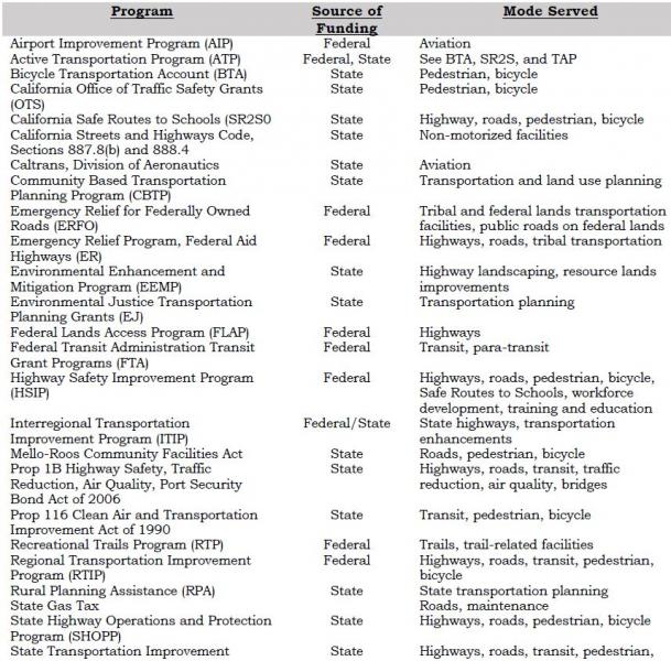
Airport Improvement Program (AIP)
The Federal Aviation Administration (FAA) provides funding for airport planning and development projects that enhance capacity, safety, security, and mitigate environmental issues. FAA grants have been utilized by the County and the Town for airport improvements. Funding is available through FY 2015 at 90% federal participation/10% local participation.
Active Transportation Program (ATP)
The Active Transportation Program consolidates various federal and state programs into a single program with the intent of making California a national leader in active transportation (biking, walking, other non-motorized transportation modes). The purpose of ATP is increased use of active modes of transportation and, in doing so, to increase safety and mobility, help achieve greenhouse gas reduction goals, enhance public health, ensure that disadvantaged communities share equally in the benefits of the program, and provide a broad spectrum of projects to benefit a variety of active transportation users. The ATP includes the Bicycle Transportation Account (BTA), the California Safe Routes to School (SR2S), Environmental Enhancement and Mitigation Program (EEMP), and the Transportation Alternatives Program (TAP).
Bicycle Transportation Account (BTA)
The BTA funds projects that improve safety and convenience for bicycle commuters in jurisdictions with an adopted Bicycle Transportation Plan (BTP). The BTA is now part of the ATP.
California Office of Traffic Safety (OTS) Grants
OTS grants fund bicycle and pedestrian safety and educational program on a competitive basis.
California Safe Routes to School (SR2S)
Eligible projects for SR2S funds include infrastructure projects in the vicinity of a school, as well as traffic education and enforcement activities within approximately two miles of an elementary or middle school. Other eligible non-infrastructure activities do not have a location restriction. SRTS infrastructure projects are eligible for TAP funds and may be eligible in the HSIP or STP. The SR2S is now part of the ATP.
California Streets and Highways Code Sections 887.8(b) and 888.4
These sections of State Code permit Caltrans to construct and maintain non-motorized facilities where such improvements will increase the capacity or safety of a state highway.
Caltrans, Division of Aeronautics, Grants and Loans
The California Aviation System Plan (CASP) identifies eligible projects for the State’s aviation funding programs. These programs provided grants and loans to eligible programs for capital improvements, land acquisition, and planning projects. Eligibility for some grants requires inclusion in the STIP. Includes Acquisitions and Development (A&D) Grant Program, Annual Credit Grants, Airport Loan Program, and State AIP Matching Grants.
Community-Based Transportation Planning (CBTP) Grant Program
This program provides funding for coordinated land use and transportation planning process that results in public engagement, livable communities, and a sustainable transportation system. Caltrans administers the program; for FY 2013-14 the grant cap is $300,000.
Emergency Relief Program for Federal-Aid Highways (ER)
Emergency Relief for Federally Owned Roads (ERFO)
These programs provide funds to repair federal-aid highways and roads on federal lands that have been damaged by natural disasters or catastrophes. The federal funds are meant to supplement state and local funds.
Environmental Enhancement and Mitigation Program (EEMP)
This is a State program funded by gas tax moneys, which provides grants to mitigate the environmental impacts of modified or new public transportation facilities. Grants are awarded in four categories: Highway Landscaping and Urban Forestry; Resource Lands; Roadside Recreation; and Mitigation Beyond the Scope of the Lead Agency. Grants are generally limited to $350,000. Grant proposals are evaluated by the California Natural Resources Agency; funds are administered by Caltrans. The EEMP is now part of the ATP.
Environmental Justice Transportation Planning Grants (EJ)
This program is administered by Caltrans and focuses on projects that address transportation and community development issues relating to low-income, minority, Native American, and other under-represented communities. The goal of the program is to improve mobility, access, safety, affordable housing opportunities and economic development opportunities for those groups.
Federal Lands Access Program (FLAP)
This program is a component of MAP-21, and is a replacement for the Federal Lands Highway Program. FLAP supplements state and local funding to improve transportation facilities that provide access to, are adjacent to, or are located within federal lands, particularly those that serve high-use recreation sites and economic generators.
Federal Transit Administration (FTA) Transit Grant Program
FTA grants provide funding for a variety of transit-related programs and activities.
- FTA Section 5304, Transit Planning Grant Program, provides funding for transit and/or intermodal planning studies in areas with populations under 100,000.
- FTA Section 5310, Elderly Individuals & Individuals with Disabilities, provides discretionary capital funds to meet the transportation needs of elderly persons and persons with disabilities. Grants may be awarded to public transit operators or private nonprofit organizations.
- FTA Section 5311, Rural Area, provides capital and operating expenses for non-urbanized transit systems in rural areas. A portion is set aside for Native American tribes.
- FTA Section 5311(b)(2)(3), Rural Transit Assistance Program (RTAP), provides funds for training, technical assistance, research, and related support services for transit operators in non-urbanized areas.
Highway Safety Improvement Program (HSIP)
A component of MAP-21 and a core federal-aid program that focuses on significantly reducing fatalities and serious injuries on all public roads, including non-State-owned public roads and roads on tribal lands.
Mello-Roos Community Facilities Act
This act allows local governments or districts to establish a Mello-Roos Community Facilities District (CFD) to provide for financing public improvements and services where no other money is available.
Prop 1B – The Highway Safety, Traffic Reduction, Air Quality, and Port Security Bond Act of 2006
Bond revenues for the following uses:
- Congestion Reduction, Highway and Local Road Improvements – for capital improvement projects to reduce congestion and increase capacity on state highways, local roads, and public transit;
- Safety and Security – for projects to protect against a security threat or improve disaster response capabilities on transit systems, as well as grants to seismically retrofit bridges, ramps, and overpasses; and
- Goods Movement and Air Quality – for projects to improve the movement of goods on state highways. Can also be used to improve air quality by reducing emissions related to goods movement and replacing or retrofitting school buses (that portion is administered by the California Air Resources Board).
Prop 116 – Clean Air & Transportation Improvement Act of 1990
Non-urban county transit funds can be made available for transit or non-motorized facilities. There has been some difficulty in approving allocations under Prop 116 due to the State’s fiscal problems.
Recreational Trails Program (RTP)
MAP-21 amended this program to make funding for recreational trails projects a set-aside from the State’s TAP funds, unless the Governor opts out in advance.
Rural Planning Assistance (RPA)
Rural Planning Assistance (RPA) funding is for state transportation planning activities and is allocated annually based on a population formula.
State Highway Operations & Protection Program (SHOPP)
The SHOPP provides funding for maintenance of the State Highway System. Projects are nominated within each Caltrans District office and are sent to Caltrans Headquarters for programming. Final projects approval is determined by the CTC, with funding prioritized for critical categories (emergency, safety, bridges, and pavement preservation). The State currently has insufficient funds to maintain the existing transportation infrastructure and there is no set formula for allocating SHOPP funds.
State Transportation Improvement Program (STIP)
The STIP is a five-year capital improvement program for the planning and implementation of capital improvements to the transportation system, including improvements to mobility, accessibility, reliability, sustainability and safety. The STIP includes two components, the Regional Transportation Improvement Program (RTIP) and the Interregional Transportation Improvement Program (ITIP). The RTIP receives 75% of the STIP funds, and the ITIP receives 25% of the funds.
The RTIP is prepared by the Mono County LTC and approved by the CTC as a part of the STIP, generally every two years. The ITIP is prepared by Caltrans and approved by the CTC as part of the STIP, although regional agencies can provide input and seek co-funding for specific ITIP projects in their region.
Surface Transportation Program (STP)
STP funding can be used for projects to preserve and improve the conditions and performance on any federal-aid highway, bridge, and pedestrian projects, including environmental restoration and pollution abatement. A portion of the STP is set aside for TAP and State Planning and Research.
Transportation Alternatives Program (TAP)
The TAP is a new program established by MAP-21 that provides funding for alternative transportation projects, including on- and off-road pedestrian and bicycle facilities, infrastructure projects for improving non-driver access to public transportation and enhanced mobility, community improvement activities, and environmental mitigation; recreational trail projects; safe routes to school projects; and projects for planning, designing, or constructing boulevards and other roadways largely in the right of way of former divided highways. TAP projects are not required to be located along Federal-aid highways. The TAP is a competitive program and is not included in the STIP. The TAP is now part of the ATP.
Transportation Development Act (TDA)
The Transportation Development Act (TDA) of 1971 created two funds primarily for public transportation: the State Transit Assistance (STA) account and the Local Transportation Fund (LTF). These are funded by a share of the state sales tax that is returned to the county of origin to support transit programs. In areas having no unmet transit needs, the funds may be spent for transportation planning or street and road purposes, at the discretion of the LTC. LTF funds are presently divided proportionately between the Town (55 %) and the County (45 %). LTF funds can be used as local matching funds for either state or federal funds. LTF funds are a traditional revenue source for Mono County and the Town.
Tribal Transportation Program (TTP)
The Tribal Transportation Program supports projects that improve access to and within tribal lands. Under Map-21, the TTP replaces the Indian Reservation Roads program, and adds new set-asides for transportation and tribal safety projects. Eligible activities include transportation planning, engineering, and maintenance, the construction, restoration, or rehabilitation of transportation facilities, environmental mitigation, and the operation and maintenance of transit facilities that are located on or provide access to tribal lands.
U.S. Forest Service
The USFS places a fee on all timber receipts from national forests. States then receive 25% of the receipts from timber sales within their boundaries, which are passed through to local agencies to benefit roads and schools in the counties where the sales occurred. In Mono County, this revenue becomes part of the county Road Fund, to be used for operational improvements.
Potential Additional Funding Sources
Other local funding sources may be available in Mono County should state and federal funding sources prove insufficient in the future, including funding for ongoing maintenance and rehabilitation projects for existing facilities. The following local funding sources could be used in Mono County and the town of Mammoth Lakes:
General Fund
Moneys come from a variety of sources, including property tax, business license tax, bed tax, motor vehicle in-lieu fees, and other fees levied by the Town and County. General fund moneys can be used to pay a portion of capital costs, or to cover budget items normally covered by LTF moneys. It is important that a local commitment be present to attract grant sources.
Development Impact Fees
Development Impact Fees may be available to offset potential transportation-related impacts identified for specific projects.
Public/Private Partnerships
Funding may be available from local agencies and private organizations. Recent cooperation between the USFS and the community of Lee Vining resulted in the construction of the Lee Vining community trail, and a local snowmobile enthusiasts group has helped develop signed snowmobile trails on public lands. In addition, it may be possible to obtain assistance from local groups and businesses in the construction and maintenance of bikeway facilities through a sponsorship program similar to the Adopt-A-Highway program implemented by Caltrans.
Other Local Sources
Other local sources may be available should state and federal funding sources prove insufficient for future projects:
Increase in Transient Occupancy Tax (TOT)
Condominium Use Tax
Local Gas Tax
Special Transportation Taxes
Fees and Charges for Services
Developers’ Contribution
Mitigation Fees
Revenue Bond
Lease Purchase Acquisition
Grants-in-Aid
Benefit Assessment Districts
County Service Area Improvement Area Bonds
Major Thoroughfare Fees
Finance Plan
Relationship Between the RTP Financial Element and the STIP
Most of the highway and road system in Mono County is either federal or state highways. As a result, the County relies heavily on the STIP and SHOPP to fund transportation improvements and maintenance projects on surface roads in the county. Projects in the Mono County RTP Financial Element are aligned with the STIP and the RTIP in order to provide consistency with those documents and in order to ensure maximum funding for projects in the county.
Existing Transportation System Operating Costs
Current projected transportation system operating costs for Mono County and the Town of Mammoth Lakes are shown in Appendix D. Those costs include the costs to operate and maintain the existing transportation system in Mono County, including the cumulative cost of deferred maintenance on the existing infrastructure. Current revenue projections for the operations and maintenance of the existing transportation system are also shown in Appendix D for both the County and the Town. For the County, Fiscal Year 2012-13 shows actual revenues & expenditures, FY 2013-14 is based on the current budget and the remaining are based on a 2% projected growth factor, except the General Fund which is projected to remain stable.
Costs & Revenue Projections for Transportation System Improvements
This section includes estimates of costs and revenue projections for transportation system improvements recommended in the Action Element, by mode and by recipient agency.
Revenues allocated for transportation purposes by Mono County have traditionally included revenues restricted to transportation uses, such as state fuel taxes (Streets and Highways Code Section 2104 and 2106), vehicle code fines, forest reserve payments, Local Transportation Funds, State Transit Assistance Funds, developers’ fees and direct assessment, and Federal-Aid Secondary. In addition, certain non-restricted funds have traditionally been used, including motor vehicle in-lieu fees, minor property rents, and federal revenue sharing. In recent years, the County has received transportation grant moneys for airport improvements and transit and has also appropriated General Fund contingency moneys when faced with emergency road repair needs.
Highways
Costs and revenue projections for proposed transportation system improvements on highways within Mono County are contained in the STIP and SHOPP (see Appendix D).
Local Roadways
Cost and revenue projections for eligible roadway construction and rehabilitation projects are contained in the STIP (see Appendix D).
Transit
Annual operating costs for transit services in Mono County are supported by LTF and STA funds. To provide sustainable funding for transit the Town of Mammoth Lakes has implemented year-round transit service. Those services are funded by a Transient Occupancy Tax (TOT) increment, along with a Transit Fee assessment, and/or funding from Transit Community Facilities District 13-003. These funding sources provide over $750,000 from the TOT and $220,000 from Transit Fee assessments. In addition, Community Facilities District 13-003 is expected to generate over $500,000 annually in the future.
Contract winter transit services are provided in the town of Mammoth Lakes to the Mammoth Mountain Ski Area, through an agreement with the Mammoth Mountain Ski Area. This winter service is privately funded and includes capital replacement costs. Summer Transit services are provided to the Reds Meadow Valley under a Special Use Permit with the USFS. One hundred percent of the operating funds for that service are provided though passenger fares.
Capital improvements to the system (e.g., bus purchases) are funded by grants or STIP funds. In addition, funds may be available for capital and expense requirements for design, development and implementations of the Eastern Sierra rural ITS transit system (i.e., bus-stop/electronic kiosks in town and county communities; bus-to-bus communications equipment) and transit management equipment.
Interregional Connections
Recommended actions for interregional connections include continued participation in YARTS and the Sierra Nevada ITS Strategic Plan planning process. Mono County contributes funding to YARTS annually.[18] The Action Element also recommends continued participation in the intercity transit planning process with Inyo and Kern counties and Caltrans, and the collaborative planning process with Inyo, Kern, and San Bernardino to pool STIP funds for priority projects. Neither of those collaborative planning processes currently has any associated hard costs.
Aviation
Project funding for identified short-term capital improvements at County airports is anticipated to come from a combination of FAA Airport Improvement Program grants (90%) and local match (10%). Projected costs for improvements at the Lee Vining Airport and Bryant Field are shown in Appendix D. Project funding for identified improvements at the Mammoth Yosemite Airport is anticipated to come from a combination of FAA grants (approximately 90%) and local match (approximately 10%). Projected costs for improvements at the Mammoth Yosemite Airport are shown in Appendix D.
Non-Motorized Facilities
Improvements to non-motorized facilities in Mono County have been included in the STIP. RTP policies call for the provision of bike lanes as a component of rehabilitation projects on streets and highways. The Town of Mammoth Lakes adopted policies in the 2007 General Plan to reduce vehicle trips and promote healthy communities by promoting feet first, transit second and automobile last. This policy is being implemented through project development review and Town-sponsored projects. In addition, the Town’s recent zoning update included development standards promoting pedestrian, biking, and alternative modes of transportation.
Financially Constrained Projects
This section contains a list of financially constrained projects for which funding has been identified, or is reasonably expected to be available within the RTP planning horizons (short-term and long-term). See Appendix D for the current STIP.
Financially Unconstrained Projects
The Mono County LTC has developed a list of financially unconstrained projects (projects that are both necessary and desirable should funding become available), which is included in Appendix D.
Potential Funding Shortfalls or Surpluses
Current funding sources are insufficient to maintain or even modestly improve Town and County road systems. Many roads in community areas throughout the county are unimproved private roads that have not been accepted in the county Road Maintenance System because of their substandard conditions. Liability issues and funding shortages impede the County's ability to accept ownership of substandard private roads. Maintenance of these roads therefore depends on private funding, which is often inadequate. Future additions to the County road system will be improved since it is the County's policy to require developers to pay for appropriately engineered streets for each new subdivision.
The fact that Mono County has a resident population of 14,202 persons according to Census 2010 and a private land base of only 6% of its total area severely limits the availability of funding for improvements to its transportation system. State redistribution of gas tax revenues and other transportation funds is based primarily on the resident population of each county and length of road system. Factors such as origination point of funds, traffic volumes, recreational benefits, travel alternatives, and need are given little weight in the State distribution formula. Mono County with its small resident population does not qualify for sufficient funding to address the impacts of the large tourist traffic volumes experienced in the county.
[18] The funding contribution for FY 2014-15 was $30,000.
Airport Land Use Compatibility Plan: A plan adopted by an Airport Land Use Commission, which sets forth policies for promoting compatibility between airports and the land uses that surround them.
All Users: Users of streets, roads and highways including bicyclists, children, persons with disabilities, motorists, movers of commercial goods, pedestrians, users of public transportation and seniors.
Arterial: A major street carrying the traffic of local and collector streets to and from freeways and other major streets, with controlled intersections and generally providing direct access to properties.
Bicycle Boulevard: The Bicycle Boulevard Design Guidebook defines a Bicycle Boulevard as “low volume” and low-speed streets that have been optimized for bicycle travel through treatments such as traffic calming and traffic reductions, signage and pavement markings, and intersection crossing treatments.
Bicycle Lane: According to Caltrans’ Highway Design Manual, Chapter 1000, a bicycle lane is a Class II Bikeway and provides a striped lane for one-way bicycle travel on a street or highway.
Bicycle Path: According to Caltrans’ Highway Design Manual, Chapter 1000, a bicycle path is a Class I Bikeway and provides a completely separated right of way for the exclusive use of bicycles and pedestrians with cross flow by motorists minimized.
California Aviation System Plan (CASP): Prepared by Caltrans every five years to integrate regional system planning on a statewide basis.
California Transportation Commission (CTC): Formulates and evaluates state policies and plans for transportation programs. Approves the RTIP, the STIP, and the SHOPP.
Collector: A street for traffic moving between arterial and local streets, generally providing direct access to properties.
Connectivity: A well-connected circulation system with minimal physical barriers that provides continuous, safe, and convenient travel for all users of streets, roads, and highways.
Conventional Highway: According to the California Highway Manual, a conventional highway is, “a highway without control of access which may or may not be divided.” Grade separations at intersections or access control may be used when justified at spot locations.
Expressway: A highway with full or partial control of access with some intersections at grade.
Federal Highway Administration (FHWA): A component of the US Department of Transportation, established to ensure development of an effective national road and highway transportation system. Approves federal funding for transportation projects.
Federal State Transportation Improvement Program (FSTIP): A three-year list of transportation projects proposed for funding developed by the State in consultation with Metropolitan Planning Organizations and local non-urbanized governments. The FSTIP includes all FTIP projects and other federally funded rural projects.
Federal Transit Administration (FTA): A component of the US Department of Transportation, responsible for administering the federal transit program under the Federal Transit Act, as amended.
Federal Transportation Improvement Program (FTIP): A three-year list of all transportation projects proposed for federal funding, developed as a requirement of funding. In air quality non-attainment areas, the plan must conform to the SIP.
Freeway: A highway serving high-speed traffic with no crossings interrupting the flow of traffic (i.e., no crossings at grade). Streets and Highways Code §23.5, in part, states that “Freeway means a highway in respect to which the owners of abutting lands have no right or easement of access to or from their abutting lands or in respect to which such owners have only limited or restricted right or easement of access.”
Heliport: A facility used for operating, basing, housing, and maintaining helicopters.
Interregional Improvement Program (IIP): One of two broad programs under the STIP. Funded from 25 % of the SHA revenues programmed through the STIP.
Interregional Transportation Improvement Program (ITIP): Funds capital improvements on a statewide basis, including capacity-increasing projects primarily outside urbanized areas. Projects are nominated by Caltrans and submitted to the CTC for inclusion in the STIP. Has a four-year time frame and is updated biennially by the CTC.
Level of Service (LOS) is a qualitative measure describing operational conditions as perceived by motorists within a traffic stream. LOS generally describes these conditions in terms such as speed and travel time, freedom to maneuver, traffic interruptions, comfort and convenience, and safety. Current LOS conditions are based on the latest traffic counts. Projected LOS conditions are based on growth factors derived from historical growth trends.
Local Scenic Highway: A segment of a state or local highway or street that a city or county has designated as “scenic.”
Local Street: A street providing direct access to properties and designed to discourage through traffic.
Local Transportation Commission (LTC): The Mono County LTC is the Regional Transportation Planning Authority (RTPA) for Mono County.
Major Thoroughfare: A major passageway such as a street, highway, railroad line, or navigable waterway that serves high traffic volumes.
Multi-modal Transportation Network: A well-balanced circulation system that includes multiple modes of transportation that meets the needs of all users of streets, roads, and highways.
National Scenic Byway: A segment of a state or interstate highway route that the USFS has designated as a scenic byway or which another federal agency has designated as a national scenic and recreational highway.
Official County Scenic Highway: A segment of a county highway the Director of Caltrans has designated as “scenic.”
Official State Scenic Highway: A segment of a state highway identified in the Master Plan of State Highways Eligible for Official Scenic Highway Designations and designated by the Director of Caltrans.
Paratransit: Transportation systems such as jitneys, carpooling, vanpooling, taxi service, and Dial-A-Ride arrangements.
Recreational Trails: Public areas that include pedestrian trails, bikeways, equestrian trails, boating routes, trails, and areas suitable for use by persons with disabilities, trails and areas for off-highway recreational vehicles, and Nordic (cross country) skiing trails.
Regional Improvement Program (RIP): One of two broad programs under the STIP. Funded from 75% of the STIP funds, divided by formula among fixed county shares. Each county selects the projects to be funded from its county share in the RTIP.
Regional Transportation Improvement Program (RTIP): A list of proposed transportation projects submitted to the California Transportation Commission by the RTPAs for state funding. Has a four-year time frame and is updated biennially by the CTC.
Regional Transportation Plan (RTP): Plan prepared biennially by regional transportation planning agencies (e.g., Mono County Local Transportation Commission, “LTC”) that describes existing and projected transportation needs, actions and financing for a 20-year period.
Route: A sequence of roadways, paths, and/or trails that allow people to travel from place to place.
Scenic Highway Corridor: The visible area outside the highway’s right of way, generally described as “the view from the road.”
State Highway Account (SHA): The primary State funding source for transportation improvements. Includes revenue from the state fuel tax, truck weight fees, and federal highway funds. Provides funding for a) non-capital outlays (maintenance, operations, etc.), b) STIP, c) SHOPP, and d) local assistance.
State Highway Operations and Protection Program (SHOPP): California state program intended to maintain the integrity of the state highway system, focusing primarily on safety and rehabilitation issues. A four-year program of projects approved by the CTC separately from the STIP cycle. See www.dot.ca.gov/hq/tpp/Offices/Planning/for further information.
State Implementation Plan (SIP): An air quality plan developed by the California Air Resources Board in cooperation with local air boards to attain and maintain Federal Clean Air Standards. See www.arb.ca.gov for further information.
State Transit Assistance (STA): Funds derived from the Public Transportation Account. Fifty percent is allocated to Caltrans, 50% to the Regional Transportation Planning Authorities “RTPAs” (e.g., Mono County Local Transportation Commission “LTC”). The funds allocated to the RTPAs are available for mass transit projects (50%) and transit operators (50%).
State Transportation Improvement Program (STIP): Includes transportation programs proposed in RTIPs and ITIPs, approved for funding by the CTC. See www.dot.ca.gov/hq/tpp/Offices/Planning/ for further information.
Terminal: A station, stop, or other transportation infrastructure along or at the conclusion of a transportation route. Terminals typically serve transportation operators and passengers by air, rail, road, or sea (i.e., airports, railroad depots, transit stops and stations, and ports and harbors.
Transit-Oriented Development (TOD): A moderate- to high-density development located within an easy walk or bicycle of a major transit stop, generally with a mix of residential, employment, and shopping opportunities. TOD encourages walking, bicycling, and transit use without excluding the automobile.
Walkability: The measurement of how walkable a community is. Walkable communities typically include footpaths, sidewalks, street crossings, or other pedestrian-oriented infrastructure
Yosemite Area Regional Transportation System (YARTS): A regional system providing scheduled service from Madera, Mariposa and Mono counties to Yosemite, connecting with the Yosemite National Park shuttle service. In Mono County, the service departs from Mammoth Lakes, June Lake, and Lee Vining. See www.yosemite.com for further information.
Documents Consulted
Eastern Sierra Landownership Adjustment Project. 2010.
Bureau of Land Management
North of Bishop Vehicle Access Strategy Plan. 1993.
Resource Management Plan for the Bishop Resource Area. 1991.
Bureau of Land Management and Inyo National Forest
Draft OHV Plan. 1994.
California Air Resources Board
Recommendations of the Regional Targets Advisory Committee (RTAC) Pursuant to Senate Bill 375: A Report to the California Air Resources Board.
California Department of Transportation
Addressing Climate Change Adaptation in Regional Transportation Plans. 2013.
California Transportation Plan 2025. California Transportation Plan Themes. Draft, July 2001.
Regional Transportation Guidelines. 2010.
California Department of Transportation, Division of Aeronautics
California Aviation System Plan (CASP). 2013.
California Department of Transportation. District 9.
District 9 Planning Documents—Transportation Concept Reports and District System Management Plans.
US 395 Origination and Destination Study, Year 2011. 2014.
US 395 Transportation Concept Report. November 2014.
California Employment Development Department (EDD), Labor Market Information Division (LMID)
Employment and Industry Projections, 2001-2012. 2013.
California Office of Planning and Research
Update to the General Plan Guidelines: Complete Streets and the Circulation Element. 2010.
California Transportation Commission
Federal Transportation Improvement Program (FTIP).
Regional Transportation Improvement Program (RTIP).
State Transportation Improvement Program (STIP).
State Highway Operation and Protection Program (SHOPP).
Great Basin Unified Air Pollution Control District
Mono County Ozone Attainment Plan. 1991.
Regulation XII. Conformity to State Implementation Plans of Transportation Plans, Programs, and Projects Developed, Funded or Approved Under Title 23 U.S.C. or the Federal Transit Act. 1994.
Regulation XIII. Conformity of General Federal Actions to State Implementation Plans. 1994.
Great Basin Unified Air Pollution Control District and Town of Mammoth Lakes
Air Quality Management Plan for the Town of Mammoth Lakes. 1990.
Air Quality Maintenance Plan and Redesignation Request for the Town of Mammoth Lakes. 2014.
Institute of Transportation Engineers
Traffic Engineering Handbook, 4th Edition. 1992.
Katz, Okitsu & Associates
Goods Movement Study for US-395 Corridor. June 21, 2006.
Local Government Commission, et al.
Main Street Revitalization Plan for US 395 through Bridgeport. October 2013.
LSC Transportation Consultants, Inc.
Inyo-Mono Counties Coordinated Public Transit – Human Services Transportation Plan Update. April 4, 2014.
Mammoth Lakes Parking Study Draft. 2005.
Technical Memorandum: Mammoth Lakes Vehicle Miles Traveled Analysis. August 2012.
Technical Memorandum: Mammoth Lakes Vehicles Miles Traveled Analysis – Comparison with 1990 Study. September, 2013.
Mono County
Mono County Emergency Operations Plan. 2004.
Mono County Airport Land Use Commission
Airport Land Use Plan – Mammoth Yosemite Airport. 1998.
Comprehensive Land Use Management Plans – Bryant Field Airport and Lee Vining Airport. Updates 2012.
Mono County Local Transportation Commission
Bus Stop Master Plan. Draft 2005.
Mono County Regional Blueprint. 2012.
Mono County Planning Department
Bodie Hills Multi-modal Plan. 1994.
June Lake Area Plan. 1991.
June Lake Area Plan Final Environmental Impact Report. 1991.
June Lake Multi-modal Transportation Plan. 1994.
June Lake Loop Trail Plan/Map.
Mono County Bicycle Transportation Plan. Draft 2014.
Mono County General Plan and Updates. 1993 and 2001.
Mono County General Plan Environmental Impact Report. 1993.
Mono County Housing Element. Draft Update 2014.
Mono County Master Environmental Assessment and Updates. 1993 and 2001.
Mono County Resource Efficiency Plan. Draft 2014.
Mono County Trails Plan (including General Bikeway Plan). 1994.
Mono County Transit Plan. 1996.
Proposed Eastern Sierra Regional Trail (ESRT). Draft 2014.
Nelson\Nygaard Consulting Services
Community of Lee Vining. Pedestrian Safety on Highway 395. October 1998.
Nelson\Nygaard Consulting Services and the Mono County Collaborative Planning Team.
Mono County Job Creation Plan for 2000-2005. 1999.
Tribal Transportation Needs Assessment, Benton Reservation, Paiute Tribe. 2009.
Tribal Transportation Needs Assessment, Bridgeport Indian Colony, Paiute Tribe. 2009.
Nichols Consulting Engineers, Chtd.
Pavement Management System for Town of Mammoth Lakes. 2000.
Pavement Management System for Mono County. 2013.
The Housing Collaborative LLC et al.
Eastern Sierra Housing Needs Assessment. Draft 2004.
Town of Mammoth Lakes
2014-2015 Mammoth Lakes pM10 and Meteorological Summary. 2015.
Emergency Operations Plan (EOP). 2001.
Mammoth Lakes Fixed Route Transit Plan. 2005.
Mammoth Lakes General Bikeway Plan. 2014.
Mammoth Lakes General Plan. 2007.
Mammoth Lakes General Plan EIR. 2007.
Draft Mammoth Lakes Mobility Element. 2012.
Mammoth Lakes Pedestrian Master Plan.2014.
Mammoth Lakes Trail System Master Plan. 2011.
Mammoth Lakes Transit Plan. 2000.
Municipal Code. Chapter 8.30. Particulate Emissions Regulations. Proposed Update, 2013.
Municipal Wayfinding Master Plan. 2012.
Mammoth Lake Pavement Management System. 2000.
Mammoth Yosemite Airport Capital Improvement Plan. (2003).
Town of Mammoth Lakes and Great Basin Unified Air Pollution Control District
Air Quality Maintenance Plan and PM10 Redesignation Request for the Town of Mammoth Lakes. 2013.
U.S. Forest Service
Inyo National Forest Land and Resource Management Plan. 1990.
Toiyabe National Forest Land and Resource Management Plan. 1986.
Winter Recreation Map. 1993.
Inyo NF Travel Management Plan. 2009.
Walkable Communities Inc.
Walkable Communities for Mono County Report. Lee Vining, Crowley, June Lake, Mammoth Lakes and Bridgeport, California. Draft, January 30, 2000.
Weber Associates, Inc.
Mammoth/June Lakes Transportation Plan, Phase II - June Lake. 1982.
Yosemite Area Regional Transportation System (YARTS)
Short-Range Transit Plan. 2012 or 2013.
Websites Consulted
California Air Resources Board
Air emissions inventory data. Information on air quality and transportation planning.
California Department of Finance
Statistical Abstract, population and income data, other socio-economic data.
California Department of Motor Vehicles
Statistics on vehicles and drivers licensed in Mono County.
California Department of Transportation
Planning guidance, traffic counts.
California Highway Patrol
Collision information, roadway statistics.
California Labor Market Information, Employment Development Department
www.labormarketinfo.edd.ca.gov
Socioeconomic data, income and poverty data.
Eastern Sierra Transit Authority
Schedules and information about ESTA routes and Carson Ridgecrest Eastern Sierra Transit (CREST) routes.
Mono County
Links to Mono County departments and to the Local Transportation Commission. Also, Mono County documents online. Link to Mono County Rideshare Program (AlterNetRides).
Town of Mammoth Lakes
Links to Town departments. Town documents online.
U.S. Census Bureau
Population, income, and poverty data.
U.S. Department of Commerce, Bureau of Economic Analysis
Income, poverty, and other socioeconomic data.
U.S. Environmental Protection Agency (EPA)
Air quality data.
YARTS.
Information on YARTS.
Persons Consulted
Bridgeport Indian Colony
Justin Nalder
Caltrans, District 9
Ryan Dermody, Terry Erlwein, Forest Becket, and other staff
Great Basin Unified Air Pollution Control District.
Duane Ono
Marine Corps Mountain Warfare Training Center
Doug Power and Col. John Gamelin
Mono County Local Planning Groups.
Antelope Valley Regional Planning Advisory Committee
Benton/Hammil Regional Planning Advisory Committee
Benton Hotsprings Landowners
Bridgeport Valley Regional Planning Advisory Committee
Chalfant Regional Planning Advisory Committee
June Lake Citizens Advisory Committee and June Lake Trails Committee
Long Valley Regional Planning Advisory Committee
Mono Basin Regional Planning Advisory Committee
Oasis Landowners
Paradise Regional Planning Advisory Committee
Upper Owens Landowners
Mono County Public Works Department
Jeff Walters, Garrett Higerd, Paul Roten
Town of Mammoth Lakes.
Grady Dutton, Haislip Hayes, Brian Picken, Sandra Moberly, Jen Daugherty
In addition, per Government Code §65352.3 under Senate Bill 18, the following California Nation American Tribes identified by the Native American Heritage Commission were sent consultation letters:
Benton Paiute Reservation, Billie (Jake) Saulque
Big Pine Band of Owens Valley THPO, Bill Helmer
Big Pine Paiute Tribe of the Owens Valley, Genevieve Jones
Bishop Paiute Tribe, Gerald Howard and Raymond Andrews
Bridgeport Pauite Indian Colony, John L. Glazier
Kern Valley Indian Council, Robert Robinson
Mono Lake Indian Community, Charlotte Lange
Walker River Reservation, Melanie McFalls
Washoe Tribe of Nevada and California, Darrell Kizer
Methodology
Traffic demand projections for the unincorporated areas of Mono County are based on trip generation rates per individual dwelling units. Traditional trip generation rates are based on rates from Trip Generation, 7th edition, Institute of Transportation Engineers, which shows the average weekday trip generation rate of 9.57 trips per detached dwelling unit on a weekday. This trip generation rate is not accurate for Mono County. As an example, if 9.57 trips per detached dwelling unit were used, the community of June Lake would generate approximately 7,943 daily trips (830 dwelling units x 9.57). The highest Annual Average Daily Traffic (AADT) on SR 158 and Lakeview Drive in June Lake is 1,500 trips per day, or almost five times less than the traffic projection rates on a daily basis shown in Table A-8.
Projected trip generation rates while based on land use and the number of housing units are subject to local factors such as:
- The seasonal nature of visitors which tends to increase Average Annual Daily Traffic (AADT) during summer months,
- The opening or closing of mountain passes,
- Some communities may have a high number of second homeowners,
- The rural nature of some communities from job centers or work locations,
- Not all traffic will enter and/or exit state highways at one specific location, and/or
- Other factors.
Mono County is using an extremely conservative trip generation rate of six trips per dwelling unit. The number of current dwelling units comes from the US Census 2010 and shown as a Census Designated Place (CDP). The Land Use Element lists all projected uses within the county, but to simplify trip generation, only the single-family residential designation is used. Projected trip generation is calculated two ways. The first uses all the dwelling units in a CDP multiplied by six trips per unit. The second calculation uses all occupied units and 50% of the unoccupied dwelling units in a CDP multiplied by six trips per unit. The number of projected new units assumes a 1% growth rate based on total units and occupied units plus 50% of the unoccupied units over a five-year time frame.
Traffic/Trips by Planning Area
Average Annual Daily Traffic (AADT) is the total traffic volume for the year divided by 365 to pass over a certain section of roadway in one day. Peak Month ADT is the average daily traffic for the month of heaviest traffic flow. The most current five-year traffic volume reporting period on the state highway system is from 2009 through 2014 by the California Department of Transportation, Division of Traffic Operations.
Antelope Valley
The primary thoroughfare in Antelope Valley is US 395. Any growth in the Antelope Valley has the potential to impact US 395. There are approximately 688 current dwelling units (D.U.) in the Antelope Valley. A 1% growth rate over a five-year period would result in 52 new units. An additional calculation on growth rate is made using only 50% of the unoccupied units or 46 new units over five years. Trip generation rates for the Antelope Valley are included in Table A-1 for total units and occupied units plus 50% of the unoccupied units. Both are based on six trips per single-family unit. The communities of Topaz, Coleville, and Walker potentially add 230 or 203 daily new vehicle trips (over a five-year period) to current traffic conditions in the Antelope Valley.
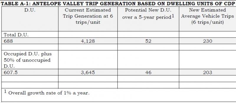
As a comparison, Table A-2 shows the annual average daily traffic (AADT) on U.S. Route 395 from 2009 to 2014 (Mill Creek Bridge and Highway 395). The most recent average daily total was 3,500 vehicles in 2014.
- If all D.U. are counted, the addition of 230 daily vehicle trips over a five year period represents a 6.5 percent increase in the average daily trips using the AADT from 2014.
- If all occupied D.U. plus 50 percent of the unoccupied D.U. are counted, the addition of 203 daily trips over a five year period represents a 5.8 percent increase in average daily trips using the AADT from 2014.
The impact of these additional trips over five years is expected to be minimal. Mono County is using a conservative trip generation rate of six trips per dwelling unit.
TABLE A-2: AVERAGE ANNUAL DAILY TRAFFIC MILL CREEK BRIDGE & HIGHWAY 395 (PM 107.105), ANTELOPE VALLEY
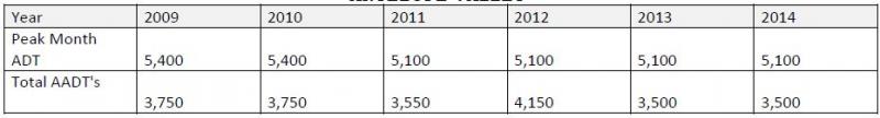
Bridgeport Valley
The primary thoroughfares for the Bridgeport area are Highways 395 and 182. There are currently 357 existing D.U. in the Bridgeport Valley. Trip generation rates for the Bridgeport Valley are based on six trips per single family dwelling. Bridgeport also has a large seasonal variation due to trans-sierra pass openings (Tioga 120 and/or Sonora 108) and second homeowners. Table A-3 shows generation rates in the Bridgeport Valley for total units and occupied units plus 50 percent of the unoccupied units. This could add 119 trips or 103 trips over a five year period. Both are based on six trips per single family unit.
TABLE A-3 BRIDGEPORT VALLEY TRIP GENERATION BASED ON Dwelling Units of CDP
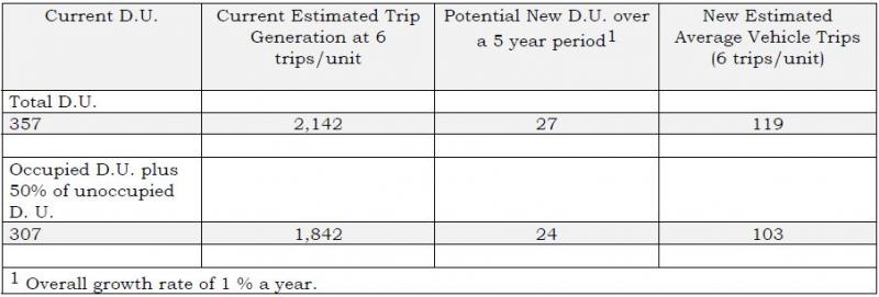
As a comparison, Table A-4 shows the annual average daily traffic (AADT) on U.S. Route 395 from 2009 to 2014 (395 & 182). The most recent average daily total was 3,600 vehicles in 2014.
- If all D.U. are counted, the addition of 119 daily vehicle trips over a five year period represents a 3.5 percent increase in the average daily trips using the AADT from 2014.
- If all occupied D.U. plus 50 percent of the unoccupied D.U. are counted, the addition of 103 daily trips over a five year period represents a 3.0 percent increase in average daily trips using the AADT from 2014.
The impact of these additional trips over five years is expected to be minimal. Mono County is using a conservative trip generation rate of six trips per dwelling unit.
TABLE A-4: AVERAGE ANNUAL DAILY TRAFFIC JUNCTION HIGHWAYS 395 AND 182 (PM 76.3), Bridgeport Valley
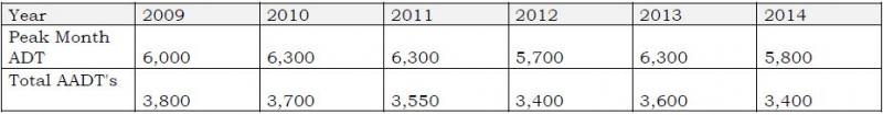
Mono Basin
Main travel routes in the Mono Basin area are Highways 395, 120 and 167. Trip generation rates for the Mono Basin are based on single family units. Lee Vining also has a large seasonal variation in AADT due to trans-sierra pass openings (Tioga 120 and/or Sonora 108). Trip generation rates for the Mono Basin are shown in Table A-5 for total units and occupied units plus 50 percent of the unoccupied units. Both are based on six trips per single family unit.
(INSERT TABLE A-5)
As a comparison, Table A-6 shows the annual average daily traffic (AADT) on U.S. Route 395 from 2009 to 2014 (North end of Lee Vining). The most recent average daily total was 3,600 vehicles in 2014.
- If all D.U. are counted, the addition of 70 daily vehicle trips over a five year period represents a 1.89 percent increase in the average daily trips using the AADT from 2014.
- If all occupied D.U. plus 50 percent of the unoccupied D.U. are counted, the addition of 59 daily trips over a five year period represents a 1.59 percent increase in average daily trips using the AADT from 2014.
The impact of these additional trips over five years is expected to be minimal. Mono County is using a conservative trip generation rate of six trips per dwelling unit.
(Insert Table A-6)
June Lake
Access to the community of June Lake is provided by Highway 158. Traffic generation rates for June Lake are based on single family residential units (SFR). June Lake also has the potential to have a high number of second home owners, seasonal variations, and may be influenced by trans-sierra pass openings (Tioga 120 and/or Sonora 108) which would affect the average annual daily traffic figures. Trip generation rates are shown in Table A-7 for total units and occupied units plus 50 percent of the unoccupied units. Both are based on six trips per single family unit.
(Insert Table A-7)
As a comparison, Table A-8 shows the annual average daily traffic (AADT) on State Route 158 from 2009 to 2014 (June Lake Village). The most recent average daily total was 1,500 vehicles in 2014.
- If all D.U. are counted, the addition of 274 daily vehicle trips over a five year period represents a 18.2 percent increase in the average daily trips using the AADT from 2014.
- If all occupied D.U. plus 50 percent of the unoccupied D.U. are counted, the addition of 186 daily trips over a five year period represents a 12.4 percent increase in average daily trips using the AADT from 2014.
This rate seems highly unlikely due to the fact that the estimated trip generation from all 820 existing units if occupied at one time could equal 4,920 trips on SR 158. This is three times higher than the AADT of 1,500 trips from 2014 on SR 158 as shown in Table A-8.
As stated in the methodology section, the ITE methodology of 9.57 trips per detached dwelling unit in rural Mono County results in unrealistic figures. Mono County has adjusted this methodology to a more reasonable, and still conservative, six trips per dwelling unit. This adjustment clearly continues to provide unrealistic numbers as described in the preceding paragraph; however, alternative methodology is lacking at this time. The current methodology does not account for second homeownership (e.g. a high percentage of vacant dwelling units), transient rentals and occupancy, concentrated traffic influx during limited timeframes due to tourist visitation, and a seasonal road closure that eliminates through traffic on SR 158.
The Average Annual Daily Traffic data does show a decrease on SR 158 from 2009 to 2014. . The impact of these additional trips over five years is not expected to be significant. Mono County is using a very conservative trip generation rate of six trips per dwelling unit as shown in Table A-7 with the trip generation rate exceeding the peak month ADT of 2,800.
(Insert Table A-8)
Long Valley
The primary access between communities in Long Valley is Highway 395. This area includes the Long Valley communities and Wheeler Crest. It does not include the Town of Mammoth Lakes. Long Valley trip generation rate is six trips per unit. A one percent housing growth rate over five years would add 63 new units if all dwelling units are used or 54 new units if all occupied units plus 50 percent of unoccupied units are used to calculate future growth shown in Table A-9.
(Insert Table A-9)
As a comparison, Table A-10 shows the annual average daily traffic (AADT) on US 395 from 2009 to 2014 at two different locations. The most recent average daily total in 2014 was 6,900 at McGee Creek Road and 8,300 at SR 203.
If all D.U. are counted, the addition of 281 daily vehicle trips over a five year period represents a four percent increase in the average daily trips using the AADT from 2014 at the Mc Gee Creek Road location.
If all occupied D.U. plus 50 percent of the unoccupied D.U. are counted, the addition of 240 daily trips over a five year period represents a 3.4 percent increase in average daily trips using the AADT from 2014 at the Mc Gee Creek Road location.
The impact of these additional trips over five years is not expected to be significant. Mono County is using a conservative trip generation rate of six trips per dwelling unit.
(Insert Table A-10)
Tri-Valley
The Tri Valley Area includes the communities of Chalfant, Hammil, and Benton. The primary thoroughfare is Highway 6. There are currently 460 existing dwelling units in the area. Trip generation rates for the Tri-Valley are based on single family detached housing. A one percent growth rate over five years using all occupied units would add 35 new units or using occupied units and 50 percent of unoccupied units would add 32 units. This would generate approximately 154 potential trips in the Tri-Valley area as shown in Table A-11.
(Insert Table A-11)
The additional projected 154 trips would utilize Highway 6 as this is the primary north/south route to Bishop. A lessor number of trips could utilize SR 120 in the northern portion of the Tri-Valley.
As a comparison, the average daily traffic on Highway 6 is only 1,890 at the junction of SR 120 (Benton Station) and 2,100 at Silver Canyon Road in northern Inyo County (see Table A-12).
If all 154 trips from new residential development traveled south into Inyo County, this would represent an increase of 6.4 percent of the 2014 AADT at the Inyo/Mono County Line as shown in Table A-12.
The impact of these additional trips over five years is not expected to be significant. Mono County is using a conservative trip generation rate of six trips per dwelling unit.
(Insert Table A-12)
(Insert Table A-13)
(Insert Table A-14)
Potential Local Transportation Projects – Examples of Project Types:
- Providing sufficient shoulders to allow for bike lanes and pedestrian paths;
- Providing additional bicycle and pedestrian facilities;
- Provision of safety and educational activities for pedestrians and bicyclists;
- Acquisition of scenic easements and scenic or historic sites;
- Scenic or historic highway programs (including the provision of tourist and welcome center facilities);
- Landscaping and other scenic beautification;
- Historic preservation;
- Rehabilitation and operation of historic transportation buildings, structures or facilities (including historic railroad facilities and canals);
- Preservation of abandoned railway corridors (including the conversion and use thereof for pedestrian or bicycle trails);
- Control and removal of outdoor advertising;
- Archaeological planning and research;
- Environmental mitigation to address water pollution due to highway runoff or reduce vehicle-caused wildlife mortality while maintaining habitat connectivity;
- Establishment of transportation museums;
- Providing turnouts and parking areas for all season recreational use and sightseeing;
- Providing fisheries enhancement projects in waterways affected by highway improvements;
- Providing additional deer warning signs in areas of heavy deer use and/or improving existing signage to emphasize the hazard in the area;
- Providing wildlife guzzlers and enhancing forage to keep wildlife from crossing highways;
- Enhancing visually objective uses alongside highways through screening, painting, fences, etc.; and
- Providing interpretive/information signs and exhibits.
Potential Local Transportation Projects by Area/Road
US 395 Antelope Valley
- Acquisition of nearby deer habitat areas.
- Enhancement of deer habitat on the west side of 395 to reduce the number of highway crossings.
- Enhance available water and forage for deer.
- Install additional deer-crossing warning signs.
- Establish roadside turnouts/deer view areas (these would be more appropriate in the Eastside Lane area, although interpretive signs directing people to Eastside Lane may be appropriate on US 395).
- Establish screening vegetation for deer around Marine housing complex, in cooperation with BLM and Marine Corps.
- Widen shoulders to allow for vehicle turnouts and scenic viewing.
SR 182 Walker River Bridge Project (at Bridgeport Reservoir Dam)
- Enhance swallow habitat.
- Enlarge existing turnout/parking area and include interpretive facilities.
- Improve SR 182 to include a bikeway to the state line.
- Provide for improved pedestrian access & crossings on the north/south sides of the bridge.
US 395 Bridgeport Main Street
- Construct northern sidewalk gap on the west end of town from Buster’s Market site to existing sidewalk.
- Improve northern sidewalk from Burger Barn to Walker River Lodge.
- Add southern sidewalk section on west end of town from Twin Lakes Road to the rodeo grounds.
- Construct (removable) curb extensions and pedestrian-activated warning lights at existing crosswalks.
- Improve walkability using features such as pedestrian furniture, pedestrian-scale street lighting, trash/recycling receptacles, bike racks, additional crosswalks, and street trees/landscaping beautification.
- Design and construct signage and wayfinding for the town core.
- Design and construct gateway monument signs at the ends of town.
Bridgeport Valley Trails
- Provide for a mountain biking trail in the Bridgeport vicinity.
- Maintain existing trails.
Twin Lakes Road Resurfacing (Bridgeport)
- Construct bike lane along shoulder or parallel to existing route, for approximately 13 miles.
- Enhance wetland values or provide replacement wetlands.
US 395 Conway Summit Passing Lane
- Complete four-laning or passing lane addition on US 395 north of Conway Summit.
- Install interpretive signs at Mono Basin Overlook regarding deer migration and restrooms.
- In conjunction with Cemetery Road project, enhance forage on BLM and State lands.
- Preserve via land purchase or other measures scenic Mono Basin properties.
- Rehabilitate/stabilize Conway Summit road cuts.
Big Virginia Lake Road and Trailhead Improvements
- Provide access/fishing pier at Big Virginia Lakes.
- US 395 Cemetery Road Passing Lane
- Fisheries enhancement in Mill Creek (creation of pools, fencing to exclude sheep, providing for fish passage through upstream diversions on Mill Creek).
- Enhance forage on BLM and State lands.
- Vista pullout and parking for Mono Lake viewing and Mill Creek access.
US 395 Four-Lane Project Between Lee Vining and June Lake
- Mono Basin Scenic Area viewpoint.
- Improve wildlife habitat.
- Interpretive turnout/parking area to highlight Walker/Parker/Rush Creek restoration.
- Lee Vining Creek interpretive signing, trail construction, and trailhead parking, coordinated with community and USFS current trail efforts.
- Visual enhancement of US 395/SR 120 junction.
- SR 120 pullouts and parking for Mono Lake viewing, visitor orientation, interpretive and information station.
- Walker and Rush creeks, access parking for fishing, hiking, etc.
- North US 395/SR 158 junction, information station to provide visitors with recreation opportunities around June Lake Loop.
US 395 – Sand House Grade Segment
- June Lake Junction self-serve information station (kiosk). Cooperative project to provide visitors with recreation opportunities around June Lake Loop.
- Pullout, scenic viewing facilities, and trail to view Mono Lake (halfway point).
- Deer watering facility at base of Sand House Grade to reduce highway crossings.
- Trailhead parking for Nordic (cross country) skiers and snowmobilers at June Lake Junction (could also be used as park-and-ride facility for commuters).
- Snowmobile crossing north of June Lake Junction.
- Parking near Bouldering Sites.
SR 158 Improvements – June Lake Loop
- Pullouts and interpretive exhibits at key points along the Scenic Byway (tied to Avalanche Bypass Road and widening projects).
- Silver Lake Roadside Bike/Pedestrian Path (tied to widening projects).
- Drainage improvements in the Village (tied to future circulation improvements in the Village). Provide drainage improvements, such as reconstructing June Lake outfall to Gull Lake inlet, and constructing a sedimentation barrier at the Gull Lake inlet.
- Parking and interpretive and rest facilities at June Lake Ballfield/Roadside Park.
- Down Canyon Trail project development and construction.
US 395 Improvements along Deadman Grade Segment
- Snowmobile trailhead (parking, information station, restroom) off Logging Camp Road.
- Nordic ski trailhead (parking, information station, restroom) off Obsidian Dome Road.
- Snowplay parking at top of Deadman Grade (allow safe parking at existing site).
Benton Crossing Road
- Erosion control for graded section of Benton Crossing Road from Watterson Grade to SR 120. Erosion control along this 15-mile section will involve approximately 36-40 acres at a cost of approximately $4,000 per acre, or a total cost of $145,500.
- Deer habitat improvement.
Lower Rock Creek Road
- Construct bike lane from south county line to US 395 (approximately nine miles).
- Develop bridge on Lower Rock Creek Trail.
Current Improvement Programs
- Mono County Highway Improvement Programs
- Mono County Roadway Improvement Program
- Town of Mammoth Lakes Roadway Improvement Program
- Mono County Airport Capital Improvement Programs
- Town of Mammoth Lakes Airport Capital Improvement Programs
- Mono County Unconstrained Projects List
Current Financing
- Mono County Projected Transportation System Operating Costs
- Town of Mammoth Lakes Transportation System Operating Costs
- Mono County Revenue Projections
- Town of Mammoth Lakes Revenue Projections
Short-Range Highway Improvement Program: SHOPP, STIP, HSIP, ATP
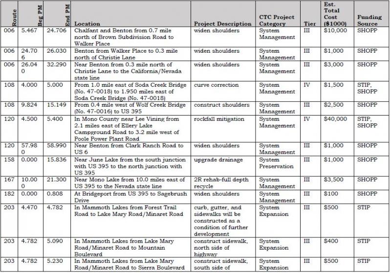
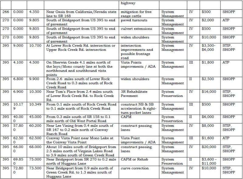
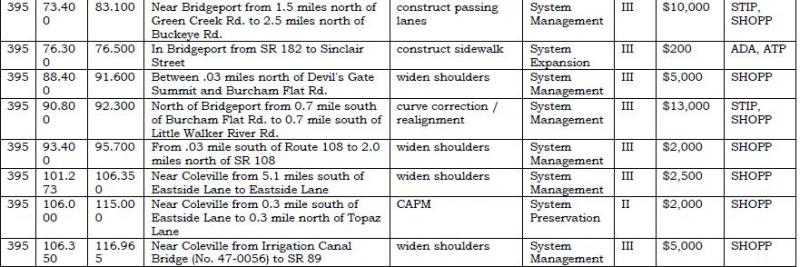
Shopp Projects
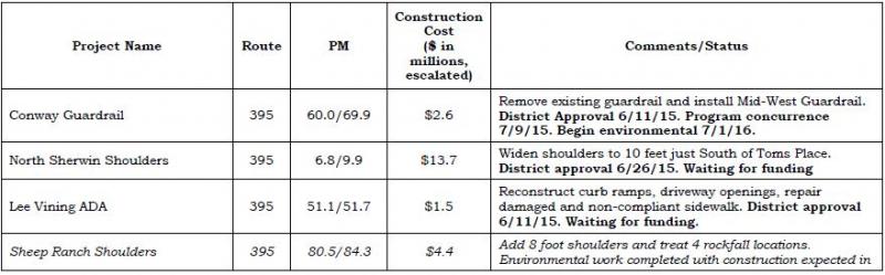
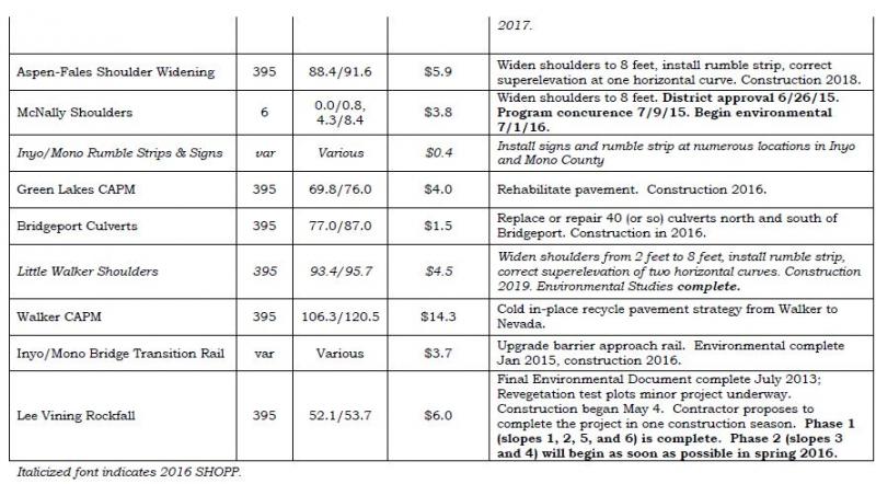
Long-Range Highway Improvement Program
Caltrans Interregional Improvement Program (IIP)*
The Mono County Local Transportation Commission supports Caltrans District 9’s IIP priority listing of projects. The following projects are ranked in order of priority and are needed to relieve congestion and improve the level of service on US 395.
![]()
* These projects should include various CMS, HAR, dynamic curve warning system, and other roadway applications in their scopes where appropriate.
Mono County Roadway Improvement Program
Mono County Short-Term Local Roadway Improvement Program
Mono County’s Short-Term Local Roadway Improvement Program focuses on road maintenance and rehabilitation. Projects will be prioritized based on the most effective use of resources. Pavement sections may not be resurfaced or rehabilitated based solely on PCI ratings. Instead, projects may be consolidated by community area and prioritized based on an assessment of the overall status of pavement within a community area. This approach will enable the County to minimize mobilization costs and maximize funding available for roadway rehabilitation.
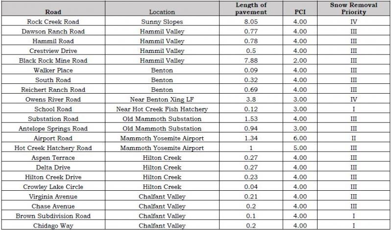
Mono County Long-Range Local Roadway Improvement Program
Mono County Long-Range Local Roadway Improvement Program
Road Rehabilitation ProjectsAirport Road (Lee Vining)
Airport Road/Hot Creek Hatchery Road
Antelope Springs Road
Benton Crossing Road
Buckeye Road
Cemetery Road
Convict Lake Road
Crowley Lake Drive
Cunningham Lane
Eastside Lane
Hackamore Lane
Hunewill Ranch Road
Lower Rock Creek Road
Lundy Canyon Road
McGee Creek Road
Mt. Morrison Road
Northshore Drive
Oil Plant Road
Owens Gorge Road
Owens River Road
Pit Road
Ramp Road
Rock Creek Road
Sawmill Road
Sherwin Creek Road
Substation Road
Swall Meadows Road
Test Station Road
Twin Lakes Road
Utility Road
Virginia Lakes Road
Yellow Jacket Road
Bridge Projects
Topaz Lane bridge repairs
Cunningham Lane bridge replacement
Bridge repairs & replacements as identified
Preventative Maintenance ProjectsCountywide projects as identified by the adopted PMS
Complete Street Projects
Bridgeport Pedestrian/Bicycle Improvements
Twin Lakes Road Bike Lanes
Lower Rock Creek Road bicycle climbing lane
Paradise trail system
Road Rehabilitation Projects by Community
Benton
Bridgeport
Chalfant
Coleville
Conway Ranch
Crowley Lake
Hammil Valley
June Lake
Lee Vining
Mono City
Paradise
Sunny Slopes
Swall Meadows
Topaz
Walker
White Mountain Estates
Main Street Revitalization Projects
June Lake (SR 158)
Lee Vining (SR 395)
Bridgeport (SR 395)
Miscellaneous Improvement ProjectsBridgeport wayfinding
Countywide transit stop improvements
Chalfant - Safe Routes to School bus stops
Countywide bike rack system
Fuel System upgrades
ITS upgrades - transit and emergency services
Public Works ITS monitoring program
Stabilization of cut slopes
Road Shop facility improvements
Road Shop site improvements
Safety upgrades - culverts, guard rail, signage, etc.
Class 1 Bike Path ProjectsBridgeport Trail System
Chalfant Loop Road
Lower Rock Creek Road to Tom's Place Connector
Mountain Gate Phase 3 trail
Owens Gorge Road to Benton Crossing Connector
Paradise trail system
New Road / Road Extension ProjectsBodie Road - construct last two miles to State Park
Lower Rock Creek Road to Crowley Lake Drive
Mono City Emergency Access Road
Owens Gorge Road to Benton Crossing
Petersen Tract Emergency Access Road
Swall Meadows Emergency Access Road
Town of Mammoth Lakes Roadway Improvement Program
Town of Mammoth Lakes Short-Term Local Roadway Improvement Program
Sherwin Creek Road Improvements
Sawmill Cutoff Road Improvements
West Airport Road Access
East Airport Access Road
Sierra Park Road Extension
Tavern Road Extension
Sierra Nevada Road Extension
Chateau Road Extension
Thompsons Way Extension
North Village Area Assessment District Street Work
OMR 3R Main Street to Minaret Rd
Forest Trail 4R
Meridian Blvd 3R SR 203 to Sierra Park Rd
Main St/Manzanita left turn lane
Main St/Mountain Blvd intersection improvements
Old Mammoth Rd/Sierra Nevada Rd intersections improvements
Azimuth/Meridian intersection improvements
Kelley/Lake Mary Road intersection improvements
Lakeview/Lake Mary intersection improvements
Westerly Majestic Pines/Meridian intersection improvements
Easterly Majestic Pines/Meridian intersection improvements
Minaret/Forest Trail intersection improvements
Minaret/Meridian intersection improvements
Minaret/OMR intersection improvements
Meridian/Sierra Park intersection improvements
Lake Mary Road/Canyon Blvd Signal Modifications
Meridian Blvd Project
Meridian Blvd Project
Waterford Avenue Crossing
Park and Ride Lots - Village, Main St, S. OMR, Airport
Pedestrian Crossing Improvements
Extend Main St. (SR 203) Turn Lane Manzanita to Minaret
Main St. (SR 203) Frontage Roads
Main St. (SR 203) Signal USPO and Mountain
Minaret/Main (SR 203) intersection improvements
Main (SR 203)/Center Street intersection improvements
Main (SR 203)/Forest Trail intersection improvements
Main (SR 203) Pedestrian and Safety Improvements (north side)
Main (SR 203) Pedestrian and Safety Improvements (south side)
Main (SR 203) Revitalization and safety Improvements
Complete Street Projects
Hillside Drive
Lake Mary Road
Laurel Mountain Road
Minaret Road
Chateau Road
Azimuth
Chaparral and extension
Lakeview Blvd
Lake Mary Loop Road
Miscellaneous Improvement Projects
Municipal Wayfinding
Townwide Transit Stop Improvements
Eastern Sierra Transit Authority facility expansion
Town Maintenance Yard Parking Barn
Welcome Center enhancements
Town Fueling Island upgrades
ITS Upgrades - Transit and Emergency Services
Public Works ITS Monitoring Program
Scenic Loop staging parking lots
Class 1 Bike Path Projects
Old Mammoth Road Mammoth Creek Park to Minaret Rd Gap
Waterford Gap
South Side Main St Callahan Way to Minaret
West Side Minaret Road
Sherwin Loop
Knolls Loop
Lake Mary Loop
Welcome Center Loop
Chair 15 Connector
Miscellaneous Connectors
Trail System Wayfinding
Mono County Airpport Improvement Program
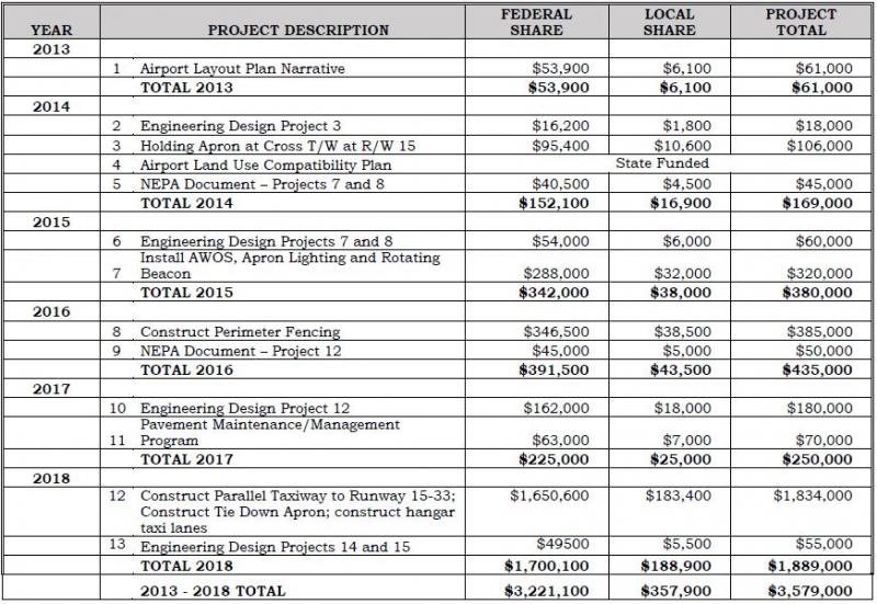
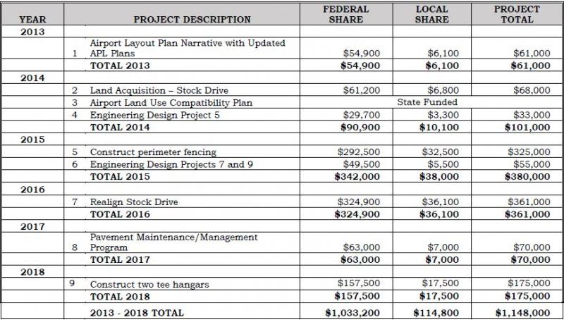
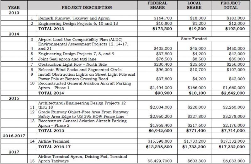
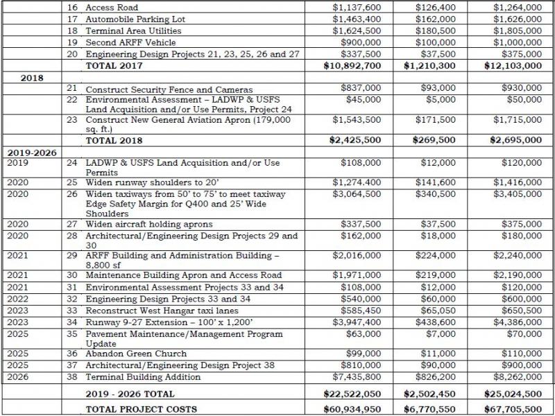
Mono County LTC Unconstrained Project List
Unprogrammed LTC Priorities: Tier 1
Chosen as a priority by three or more LTC commissioners
- Mono County community-based pavement rehabilitation projects
- N. Conway passing lane or four-lane project (approved MOU project in 2014)
- Realignment of Lower Rock Creek Road and US 395 intersection
- Mammoth Yosemite airport deer/snow safety fence
- US 395 deer/snow safety fence from Caltrans McGee Creek Maintenance Station to SR 203 and a portion of 203
- Countywide bridge plan / Topaz Lane bridge replacement (staff only, brought before Board)
- Southerly Airport Access Road construction (staff only, brought before Council)
- SR 203 Main Street signal project (staff only, brought before Council)
Projects of Interest: Tier 2
Chosen as a priority by two LTC commissioners
- Catch up with backlog of road striping on County roads to improve safety (also staff priority)
- Reinitiate US 395 N. Sherwin Grade improvement project
- Conway Summit cut: complete evaluation of slope stabilization trials and complete
- US 6 flood control issues (bridges, culverts)
- Tioga Pass Heritage Highway: safety & scenic/interpretive enhancements
- Add Mammoth as destination to mileage signs in Nevada and/or I-15
- Add northbound left turn lane at US 395 and Mill Canyon (north of Walker)
- Repainting and maintenance of Mono County entry signs on US 395
- Add Mammoth/Hwy 203 as destinations to US 6, SR 120, and Benton Crossing Road signs
Projects of Interest: Tier 3
Chosen as a priority by one LTC Commissioner and RPACs or County staff
- Add Bridgeport Twin Lakes Road shoulder and bike lanes
- Add SR 182 shoulder and bike lanes
- Develop trails system in Bridgeport – winter & summer
- Add Bridgeport welcome/gateway signs
- Add bike lanes and/or wider shoulders on major routes in Chalfant
- Expand Lee Vining/June Lake Main Street Revitalization & walkability
- Add bike path connecting Chalfant Loop Rd to Chalfant proper (1 mi) creating a safe bike route between White Mtn. Estates and Chalfant
- Bridgeport Main Street projects
- Bridgeport wayfinding tied to School St Plaza & County “campus”
- Bridgeport Main St sidewalk improvements: curb extensions, pedestrian furniture, landscaping and street trees, finish sidewalks
Projects of Interest: Tier 4
Chosen as a Priority by one LTC commissioner
- Designate SR 158 as State Scenic Highway
- Create a Transportation Asset Management Plan matrix for the Town
- Construct scenic pullouts on US 395 in Bridgeport Valley
- County Road Shop/Yard in Bridgeport: landscape/screen from US 395, add dark-sky compliant lighting
- Hwy 203 Main Street Revitalization
- Repair eroding slopes at Auchoberry Pit
- Renovate June Lake Loop rumble strip @ US 395 to be safer for bicyclists
- Screen old sheriff’s substation from US 395 with berm
- Utilize self-weathering steel guardrails in the county
- Add grooves cut across US 395 in varying widths to generate different sounds that “play” a song as cars pass over to prevent drivers falling asleep
- Add signage along US 395 to identify special geographic features
- Add right turn lane at McGee on southbound US 395
- Pave the last two miles of Bodie Road to the State Park
- Rehabilitate and stabilize cut slope above ballfield on Crowley Lake Drive
- Rehabilitate and stabilize slopes on Lower Rock Creek Rd
- Keep Crestview rest area open year round
- Reinitiate & complete deer fence/grade separate at Sonora Junction
- Work with Inyo LTC to designate all of US 395 as State Scenic Highway
Mono County Projected Transportation System Operating Costs
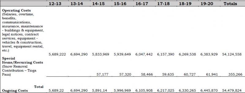
Fiscal Year 2012-13 is actual expenditures; FY 2013-14 is based on the current budget; remaining years are based on a 2% projected growth factor.
Contributions for snow removal on Tioga Pass are based on the average of actual contributions in 2010 and 2011, calculated with a 2% growth factor.
Town of Mammoth Lakes Projected Transportation System Operating Costs
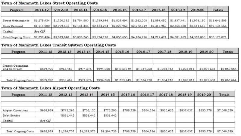
Fiscal Year 2012-13 is actual expenditures; FY 2013-14 is based on the current budget; remaining years are based on a 2% projected growth factor.
Mono County Revenue Projections
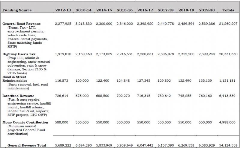
Town of Mammoth Lakes Revenue Projections
Town of Mammoth Lakes Streets Revenue Projections
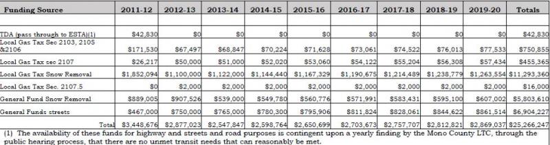
Fiscal Year 2012-13 is actual revenues; FY 2013-14 is based on the current budget; remaining years are based on a 2% projected growth factor.
Town of Mammoth Lakes Transit System Revenue Projections
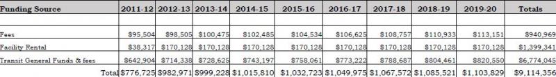
Fiscal Year 2012-13 is actual revenues; FY 2013-14 is based on the current budget; remaining years are based on a 2% projected growth factor.
Town of Mammoth Lakes Airport Revenue Projections
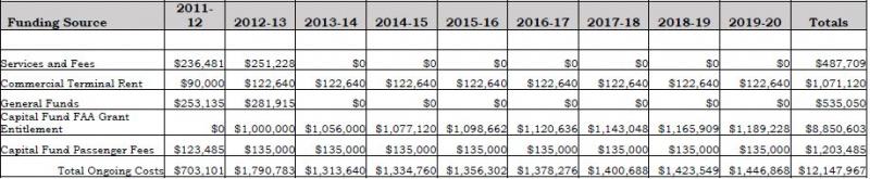
Fiscal Year 2012-13 is actual revenues; FY 2013-14 is based on the current budget; remaining years are based on a 2% projected growth factor.
This map is available online at http://monocounty.ca.gov/sites/default/files/fileattachments/public_work... or by calling the Public Works Department at 760.932.5440.
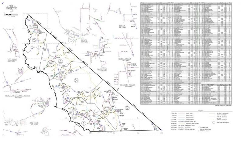
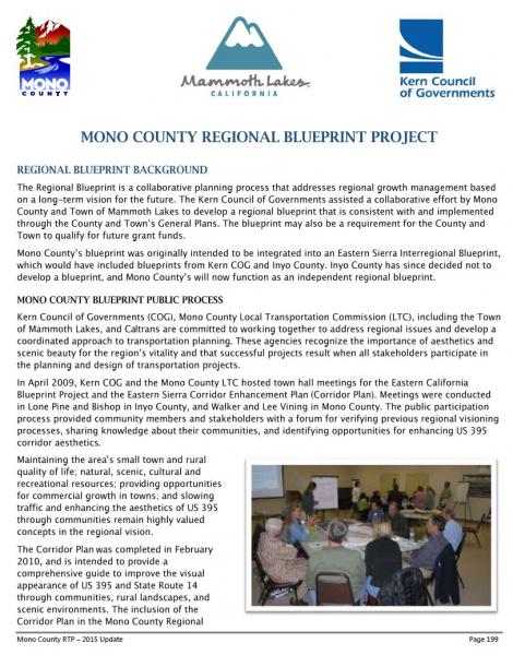
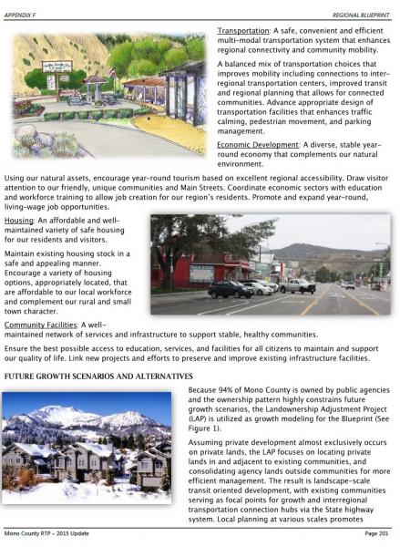
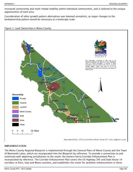
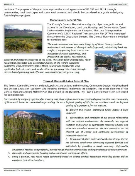
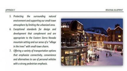
Table of Contents
II. Existing Trails Systems and Policies.
IV. Issues, Opportunities, and Constraints by Planning Area.
VI. Regional and Community Routes.
I. Purpose of Plan
The overall purpose of the Mono County Trails Plan is to establish trail systems that facilitate multi-modal travel and recreation within, around and between unincorporated communities in the county. The Plan addresses regional routes that provide access to communities throughout the county and to major recreational areas and existing trail systems, and community routes that provide access throughout communities and to surrounding recreational areas.
The Trails Plan is intended to expand upon and implement policies in the Mono County General Plan, associated Area Plans, the Mono County Regional Transportation Plan, and to coordinate with the applicable plans of federal land management agencies. The Plan focuses primarily on the development of facilities for recreational users, both residents and visitors.
Specific purposes of the Plan are to inventory existing trail systems in the county and to provide a concise summary of those systems, to evaluate the needs of the County’s communities for new local community routes and the possibility of linking existing routes, to designate routes and prioritize their development, and to delineate policies for the future development of trails systems in the county.
II. Existing Trails Systems and Policies
Inventory of Existing Trails Systems
Trail:- A track made by passage, especially through a wilderness.
- A marked path through a forest or mountainous region.
- A course followed or to be followed.
The term “trail” can encompass a wide variety of uses when it is defined as a course to be followed. Trails in Mono County, with its many recreational resources, include wilderness trails used by hikers and equestrian users, dirt roads used by off-highway vehicles and equestrian users, signed trails for Nordic skiing and snowmobile use, scenic byways used as sightseeing trails, hiking trails at developed recreation sites, and roadways used by both mountain bikers and touring bicyclists. Trails serve two purposes – recreational experience for those who travel along them and as link between different areas of the county.
Since so much of the land in the county is publicly owned (approximately 94%), most of the existing trail systems in the county are on public lands and are managed by either the U.S. Forest Service (USFS) or the Bureau of Land Management (BLM). The California State Park units in the county, Bodie State Historic Park and Mono Lake Tufa State Reserve, contain internal trails systems used by visitors to the parks. The highway system in Mono County also functions as a trail system, primarily for motorists and bicyclists.
USFS/Inyo National Forest and USFS/Humboldt-Toiyabe National Forest Trails
Lands administered by the USFS in Mono County contain extensive trails systems ranging from backcountry wilderness trails to paved recreational trails in concentrated recreation areas. The Land and Resource Management Plans for both the Inyo National Forest and Humboldt-Toiyabe National Forest contain policy direction for trails and roadways for each of the land management areas in the forests. In addition, the Forests have developed specific plans and resources for different types of uses, such as the Humboldt-Toiyabe Bridgeport Winter Recreation Area Plan and the Interagency Off-Highway Vehicle Trail Maps by the Inyo National Forest and the BLM.
Public lands administered by the USFS run the entire length of the county on its western border, running east to US Highway 395 and in some cases, farther. These are the most heavily used and developed Forest lands, with more concentrated recreational areas and facilities adjacent to communities or major recreation areas such as June Mountain Ski Area and the June Lake Loop. Other Forest lands in the eastern part of the county are less developed and have fewer users.
The corridor from Mammoth Lakes to June Lake is one of the most heavily used in the southern portion of the county, while the Twin Lakes and Sonora Pass areas are popular in the northern portion of the county. National Forests have many developed recreational facilities, including campgrounds, picnic areas, trail heads, and signed trails for hiking, biking, equestrian, snowmobile, and Nordic ski use.
Maps of trail systems on the forests are available from district ranger stations and visitor centers. In addition, a number of specialized maps have been developed showing cross country ski trails, snowmobile routes, and mountain bike routes, particularly for the heavily used area between Mammoth Lakes and June Lake. The Interagency OHV maps provide detailed mapping of roads for the Inyo National Forest.
Bureau of Land Management Trails
Public lands administered by the BLM in Mono County do not generally contain developed trails systems. They do contain an extensive system of dirt roads used by hunters, anglers, equestrians, OHV users, and others wishing to explore the more arid sagebrush scrub and pinyon-juniper communities found on BLM lands in the county. Generally, marked roads are major routes between various areas in the county, such as the roads leading from US Highway 6 in the Tri-Valley area to the Crowley Lake area.
The BLM Resource Management Plan contains policy direction for trails and roadways. The BLM has also developed the North of Bishop Vehicle Access Strategy Plan for the Bodie Hills and for the lands it manages in the Bridgeport Valley and Antelope Valley areas. The overall intent of the BLM is to maintain semi-primitive conditions on the lands it manages and not to develop facilities on those lands.
California Department of Parks and Recreation Trails
The California Department of Parks and Recreation updated Recreational Trails Plan in 2002. The Plan focuses on….: Bicycling; Boating; Off-Road Vehicle Use; and Hiking and Equestrian Use. Each element describes existing conditions, states goals and objectives, and identifies recommended projects. Projects are recommended in areas of high demand, generally near urban areas. The Plan contains useful information concerning trail system development, including design standards and guidelines. There are no proposed state trail systems in Mono County, although each of the county’s State Park units, Bodie State Historic Park, and Mono Lake Tufa State Reserve, contains internal trail systems. Trails within the Bodie State Historic Park are addressed within the Bodie State Historic Park Resource Management Plan.
Town of Mammoth Lakes: “Mammoth Lakes Trail System”
The “Mammoth Lakes Trail System” is a partnered effort of the Town of Mammoth Lakes and the US Forest Service to implement the Town’s 2011 “Trail System Master Plan.” The Town and the US Forest Service have executed several agreements to facilitate the effort, and the citizens of Mammoth Lakes have approved funding resources for implementation through Measures “R” and “U”. The Town has contracted with Mammoth Lakes Recreation, a community benefit non-profit corporation established by the Town, to provide oversight for the Mammoth Lakes Trail System program and the Town has hired a full time Trails Coordinator. The primary uses of the proposed multi-use trail system are described on the “Activities” section of the Mammoth Lakes Trail System website at mammothtrails.org. Trails identified in the Plan as “Future/Alternative Trails” would connect trails and bikeways within the more-developed area of the town to trails in the adjacent unincorporated area. Please contact the Town’s Trails Coordinator for more information on the Town’s “Trail System Master Plan” and the Mammoth Lakes Trail System.
Sightseeing Trails – Scenic Byways
Sightseeing is a major recreational activity in Mono County that occurs primarily along the highways. US Highway 395 (US 395) through the county, State Route 120 (SR 120) in Lee Vining Canyon, State Route 158 (SR 158) in the June Lake Loop, and State Route 270 (SR 270) to Bodie are heavily used for sightseeing and touring.
A major portion of US 395 is a state-designated scenic highway. SR 120 in Lee Vining Canyon is a National Forest Scenic Byway, and the Forest Plans and BLM Plan recommend scenic byway designations for several other roadways in the county. The Coalition for Unified Recreation in the Eastern Sierra (CURES) has made interpretive improvements along the scenic highway/byway 395 corridor in Mono County, including development of kiosks and informational materials along US 395 and SR 120 (Lee Vining Canyon) to enhance the sightseeing experience.
Visitors to the county would benefit from similar facilities along other local roadways, particularly along SR 158 (June Lake Loop), and SR 270 to Bodie, both of which are heavily used for sightseeing.
Off-Highway Vehicle Trails
An extensive system of off-highway vehicle trails exists in the county, as discussed in the previous section on BLM trails. The BLM and USFS management goals for these routes are to maintain the existing semi-primitive recreational experience by providing a predominantly natural environment. The roads will remain dirt; there will be no developed facilities except for road signs on major routes and a few informational kiosks. The BLM and USFS have developed a “Tread Lightly” educational program for OHV users, similar to the program for wilderness users.
Outside the highway system, the County’s dirt-road system may be the most heavily used existing trail system. Not only are the roads used to provide access to recreational areas, they are also used as recreational experiences themselves, to provide access to resources such as firewood and as alternate access routes between different parts of the county.
Pedestrian Trails
Pedestrian hiking trails are largely limited to backcountry trails on forest lands. In communities, pedestrian activities occur along streets and in some communities on limited sidewalk systems. Outside communities, hiking occurs on the extensive dirt road system and on public lands. The interest for additional pedestrian facilities outside community areas is growing and several communities are pursuing additional pedestrian facilities and related streetscape improvements.
Nordic Ski Trails
There are marked Nordic ski trails at Smokey Bear Flat, near Mammoth, in the Deadman Summit area, and within June Lake. Nordic skiing also occurs on public lands in unmarked areas. Existing trails generally are not adjacent to communities in the county; there is some potential for additional trails near communities.
Snowmobile Trails
There are marked snowmobile trails at Smokey Bear Flat, near Mammoth, in the Deadman Summit area, and near June Lake. Snowmobile use also occurs on public lands in unmarked areas. Marked trails are often the result of cooperative efforts among the USFS, snowmobile enthusiast groups, and local snowmobile rental operators. Snowmobile use does occur on a limited basis immediately adjacent to community areas.
Equestrian Trails
Equestrian use occurs along existing roads and trails or along trails on public lands that are also used by hikers and bicyclists. Presently, there is concern from equestrian users over the sharing of trails with bicyclists. This issue needs to be resolved by all trail users. Equestrian users often trailer their horses to trail heads, or parking areas outside their communities. Visitors may use the services of an outfitter or a pack station.
Mono County General Plan Policies
The Mono County General Plan, updated in 2015, contains policies relating to trails and recreation in both the Circulation Element and the Conservation/Open Space Element. The General Plan Circulation element also includes trail systems maps and route descriptions for a trail system in the county.
Mono County Regional Transportation Plan Policies
The 2015 update of the Mono County Regional Transportation Plan contains the same policies and the same trail maps as the 2015 update of the county General Plan Circulation Element.
III. Community Trails
Issues, Opportunities, and Constraints
The following section addresses pertinent issues, opportunities, and constraints, including those identified in the Circulation Element of the General Plan and in the Regional Transportation Plan. Bikeways are discussed in the Bicycle Transportation Plan.
Demand for TrailsAs the previous chapter noted, Mono County has numerous trails and roadways that provide various recreational experiences for visitors and residents. Regional routes, which are mostly roadways, provide accessibility to most areas of the county and to recreational areas. The system is fairly well established and consists of the highway system and dirt roads on public lands.
Community routes are less well established. Opportunities exist to develop new trails and to expand existing informal trails in community areas, and to provide trails that link community and recreational areas and facilities. Many community routes remain undeveloped.
In community areas, the primary need is for pedestrian and bike trails. Demand for other types of trail is limited and is often provided by facilities on public lands outside community areas. There is a potential, however, to create multiple-use trails. The seasonal nature of recreation in Mono County creates a need for different types of trails at different times of year. Trails providing pedestrian, biking, and equestrian opportunities in the summer work equally well as Nordic ski facilities in the winter.
Trails are in greater demand in certain communities than in others. Communities with concentrated recreational use and heavy visitation have a greater need for facilities than communities that are primarily residential in nature and that receive little recreational use.
Scenic Byways and TrailsSightseeing along roadways is a major recreational activity with a number of scenic routes in Mono County. Scenic route designations include State Scenic Highways 395 and 89, Scenic Byways along SR 120 and US 395, and a number of other roads designated as County scenic highways. The Mono County Master Environmental Assessment provides a comprehensive overview of designated scenic routes within the region.
Off-Highway Vehicle TrailsOff-highway vehicle facilities include the existing system of roads and trails on public lands. The BLM’s and USFS’s management plans for those lands adequately address management needs, primarily the signing of major routes and public education concerning the need to tread lightly.
Because the road system is so extensive, it is easily accessible from points throughout the county, including community areas. Major access points are signed, and maps are available from the BLM and USFS showing those routes.
Pedestrian TrailsTwo types of pedestrian trails exist in or adjacent to Mono County communities, sidewalks and walking/hiking trails or paths. Some communities have sidewalks, but no community has extensive pedestrian facilities. The County has no active program for striping or marking pedestrian facilities, nor has it been a major concern of Caltrans in the past. With increased recreational use, particularly in community areas during peak season, the need for markings and traffic direction for pedestrians is increasing in some communities.
Additional pedestrian improvements are needed in most communities. There is also a need to improve existing routes used by pedestrians, such as widening the shoulder on roadways or providing an alternate pedestrian route. Pedestrian improvements would benefit communities in several ways; i.e., facilitating links between transportation modes, economic development benefits resulting from more-active commercial areas, increased livability of communities and increased safety resulting from elimination of the pedestrian/vehicle conflict in winter.
Trail-side Facilities
Trail-side facilities can improve the user’s enjoyment and understanding of the land and resources adjacent to and visible from a trail. Such facilities may include restrooms, drinking water, benches, picnic areas, parking areas for larger vehicles with horse trailers, and interpretive and way-finding signs. Trail-side facilities are most appropriate for developed trail systems, such as scenic byways and nature/interpretive trails, or at entrance points to less-developed trail systems, such as trail heads or major access roads to off-highway vehicle roads.
Public lands in Mono County contain a variety of trail-side facilities, including campgrounds, trail heads, picnic areas, and information kiosks. Trail-side facilities in community areas may include restrooms, benches, picnic areas, way-finding and interpretive signs, all typically concentrated in a rest area or park. Pedestrian amenities may also include improved lighting, landscaping paving, street furnishings (benches, drinking fountains, trash receptacles), improved street crossing, and improved access to parking areas.
Design StandardsSince Mono County has numerous trails and roads that range from somewhat rugged to extremely difficult, community trails should focus on providing accessibility for everyone. Trail-side facilities developed in conjunction with new or existing trails should be designed to be accessible to persons with disabilities.
Since the focus of many trails and roads in Mono County is the scenic beauty of the surrounding environment, trails and associated facilities need to blend into that environment to the greatest extent possible. Similarly, in community areas trails and facilities need to be designed and constructed to complement the existing setting.
Environmental concerns regarding the construction of trails are addressed by the USFS Standard Trail Plans and Specifications. Design considerations for accessibility are addressed by the Americans with Disabilities Act and the California Building Code.
A primary consideration in the design and construction of trails and facilities is the ongoing maintenance of those facilities. Facilities should be designed to be low maintenance and long-lasting. Cooperative maintenance should include all user organizations; i.e., hikers, bikers, and equestrians.
IV. Issues, Opportunities, and Constraints by Planning Area
Antelope Valley
- Recreation destinations in the area include Topaz Lake and the West Walker River. At Topaz Lake there is the potential to provide increased recreational opportunities, including hiking trails, rest areas, picnic areas, etc. The Walker River Irrigation District (WRID) manages the lake and owns much of the property surrounding the lake.
- There is also the potential to develop public access trails to the West Walker River throughout the Valley. This would require cooperating with the WRID and private landowners who own most of the land in the valley adjacent to the river.
- Off-Highway Vehicle (OHV) use in the Antelope Valley occurs primarily on surrounding public lands.
- There is an opportunity to enhance sightseeing in the Antelope Valley and to promote Walker as a gateway community to the Scenic Byway south of Walker.
Sonora Junction/Devil’s Gate/Swauger Creek
- The Devil’s Gate to the Swauger Creek area is an isolated residential area with limited year-round occupancy. Private parcels in the area are surrounded by public lands that provide recreational opportunities for residents.
- Sonora Junction area includes river access, campgrounds, a pack station and associated trails generally located on public land.
Bridgeport Valley
- Major recreational destinations in the Bridgeport Valley include Bridgeport Reservoir and Twin Lakes. A bicycle route to Twin Lakes from Bridgeport, and to the state line on SR 182, is discussed in the Bicycle Transportation Plan and Regional Transportation Plan. The historic building tour included in town, staged from the Bridgeport Park next to the museum, is part of the Eastern Sierra Scenic Byway.
- There is a need to enhance pedestrian facilities along US 395 from the Evans Tract to town, and along SR 182 from town to the residential areas along the reservoir. Residents, especially children, currently must walk along the highways.
- OHV use in the Bridgeport Valley occurs on surrounding public lands. The BLM’s North of Bishop Vehicle Access Strategy Plan addresses management of OHV activity on those lands.
- Interest is high in creating a multi-use year-round trail system in the Valley that would function as bicycling, pedestrian, and/or equestrian trails in summer and Nordic skiing trails in winter. This would be particularly feasible on Timber Harvest Road and on a route between Timber Harvest Road and town.
Bodie
- The Bodie Bowl area is both a State Historic Park and National Historic Landmark. The remoteness of Bodie provides excellent opportunities for enjoyment of this historic ghost town and its scenic backdrop; and is a major recreational attraction for Mono County. Alternative modes of transportation are encouraged in the Bodie Bowl Area of Critical Environmental Concern (ACEC) and Bodie Hills Planning Area Cooperative Management Plan.
- The Bodie Bowl ACEC and Bodie Hills Planning Cooperative Management Plan, Bodie State historic Park Management Plan, and supporting BLM planning documents provide direction for pedestrian, bicycle and/or equestrian trails access into Bodie. Existing trails, rather than new trails, are to access the area whenever practical.
Virginia Lakes
- The Virginia Lakes area is heavily used by seasonal residents and visitors. A number of trails and roads exist in the area. Pedestrian and bike facilities should be considered during any roadway improvements in the area.
Mono Basin
- The Mono Basin is a heavily used recreational destination. A number of existing trails and roads lie within the boundaries of the Mono Basin National Forest Scenic Area. The Scenic Area’s Comprehensive Management Plan governs use of those facilities.
- The Mono Basin has two communities: Lee Vining and Mono City. Pedestrian facilities in Lee Vining could be improved by streetscape improvements along US 395 right of way and by the provision of additional parking. The Mono Yosemite Trail Plan also identifies opportunity to connect Mono City to Lee Vining with trail access.
- Opportunity exists to extend the Lee Vining Creek trail up Lee Vining Canyon to the campgrounds and other locations as specified in the Mono Yosemite Trail Plan.
- Access for pedestrians and equestrians along the west side of Mono Lake is limited to the shoulder of US 395 or to trails on the steep hillside to the west. Residents have expressed concern that access be improved along this portion of the highway.
June Lake Loop
- The June Lake Loop is a heavily visited recreational destination that experiences occasional traffic congestion. The Village area, in particular, lacks adequate parking and pedestrian facilities.
- The June Lake Area Plan, part of the county General Plan, contains policies that stress the need to develop a trail system linking commercial, residential, recreational, and parking nodes. This trail system should be designed and implemented to provide year-round recreational and commuting opportunities consistent with the June Lake Loop Trail Plan/Map.
- The June Lake Loop Trail Plan/Map recognizes potential exists to develop trails to the Village and to surrounding recreational areas within the June Lake Loop.
- Northshore Drive and the Rodeo Grounds/West Village area provide opportunity for trails to access the June Lake ball field, the June Mountain Ski Area, and Gull and June lakes.
- The June Lake Trail Committee meets regularly, conducts fundraising, sponsors an annual Trails Day, and oversees implementation and updates of the Trail Plan.
Mammoth Vicinity/Upper Owens
- Recreation is the principal use of this area; much of it occurs on the extensive road system in the area and on marked Nordic ski trails and snowmobile trails. The USFS and BLM resource management plans and other planning documents address management of these facilities.
- Pedestrian use of Substation Road is extensive and occurs on a year-round basis. On much of the road, shoulders are not adequate to allow pedestrians to get off the roadway. People walking on the road, or in the surrounding hills, park off the road in several areas. There is potential to develop a parking area, picnic area, visitor kiosk, and interpretive site in the vicinity. Interpretive facilities/trail related to the Casa Diablo resource area is anticipated and would contribute to the Highway 395 Scenic Byway corridor.
- The Town of Mammoth Lakes has a planned trail system within the town’s boundaries. Connecting this trail system to trails in the surrounding unincorporated area would create additional opportunities for users of the Town’s system. The Whitmore Track area is used as a staging and training area for high- altitude long-distance running.
Long Valley
- Crowley Lake Drive provides access to several recreational areas in nearby Sierra Nevada canyons and is also a popular recreational route itself. Pedestrians and bicyclists use it for local rides or as a portion of longer tours. Pedestrian safety is a concern of local residents, particularly along Crowley Lake Drive and South Landing Road.
- Benton Crossing Road is popular for pedestrian use as well as bicycling. Shoulders on the road have been improved for bicycling and running use.
- Concepts have been discussed to develop a hiking, cycling, and equestrian trail around Crowley Lake if demand warranted such a trail. Various roads and trails, which could be linked to provide access, now exist most of the way around the lake. Since the Los Angeles Department of Water and Power owns much of the land around the lake, a trail system would require its cooperation.
- Opportunities exist for other regional trails in the long valley area, including a trail connecting the Mammoth area with Long Valley via use of existing roads. Better signage and completion of a small portion of trail near Tobacco Flat would be necessary. Currently, an unofficial parking area exists at the northern end of Crowley Lake Drive and US 395. This area could be improved to provide better access for all trail users.
- Additional trails between Long Valley and Tri-Valley provide access along Benton Crossing Road to the glass Mountains, Casa Diablo hills, volcanic tablelands, and the Owens Gorge.
Wheeler Crest/Paradise
- Wheeler Crest/Paradise is a residential area with limited demand for pedestrian or equestrian trails. Residents currently use the existing road system and surrounding public lands for a variety of trail and recreational activities. Lower Rock Creek Trail and Lower Rock Creek Road are a recreational destination for visitors and bicyclists.
Tri-Valley
- The Tri-Valley area includes three residential communities with limited commercial facilities that receive limited recreational use. Demand for pedestrian or equestrian facilities is growing.
- US Highway 6 (US 6) through the region lacks turnouts or rest-area facilities for sightseers. Paved turnouts with interpretive signing would enhance travelers’ enjoyment of the road.
Oasis
- Oasis is an isolated agricultural area with little recreational use and limited demand for trails.
V. Policies
The following section contains new policies as well as pertinent policies from the Circulation Element of the General Plan and the Regional Transportation Plan.
Goals
- Develop a cohesive regional and community trail system that provides access to all communities and to major recreational areas.
- Work with communities in order to gain consensus on current and future trail improvements and priorities.
General Development Standards
Policy 1. Where possible, utilize existing roads and trails to develop the trail system in Mono County.
Policy 2. Work with appropriate agencies to develop trails and associated facilities that connect to existing trail systems.
Policy 3. When possible, plan and develop trails as multi-use year-round facilities.
Policy 4. Concentrate developed trails and facilities in the most heavily used areas such as in and around communities.
Policy 5. Development of trails on County roads and private property should be consistent with goals and policies for trails development and recreational use on adjacent public lands.
Policy 5a. Encourage agencies to manage OHV use on public lands to minimize user conflicts.
Policy 6. Provide input to federal and state agencies on the development of trail systems on public lands, particularly in areas adjacent to communities.
Policy 7. Design trails to limit impacts to sensitive plant communities including wetland and riparian corridors.
Policy 8. Incorporate signage into trail design to encourage compliance with trails rules and etiquette.
Community Trails
Policy 9. Utilize community trails to connect commercial, employment centers, community facilities, recreational, and residential areas in communities, and to link communities to surrounding trail systems and recreational areas.
Policy 10. Community trails should include way-finding and informational signage to facilitate their use.
Policy 11. Where feasible, and where demand warrants, design and construct community trails as multi-use facilities and as year-round trails.
Policy 12. Seek funding for the development and maintenance of community trails.
Policy 13. Work with subdividers to provide connecting paths to existing local and/or community, educational, and recreational facilities.
Policy 14. Work with community groups to refine and implement the conceptual trail schemes presented in this Plan and supporting documents.
Policy 15. Promote healthy lifestyles by integrating trails into communities. At the community level, connect neighborhoods, community facilities, and main streets via trail systems. At the regional level, connect communities to scenic resources, appropriate historical/cultural places, and recreation opportunities, as well as to other communities.
Policy 16. Reference and update existing community trail documents in establishing trail priorities.
Policy 17. Investigate the feasibility of improving connections of the regional OHV network with supportive communities, such as combined use designations for County roads in northern Mono County.
Design Standards
Policy 18. Trails shall be developed and maintained in conformance with the USFS’s Standard Trails Plans and Specifications.
Policy 19. Trails shall be designed for accessibility in accordance with the Americans with Disabilities Act and the California Building Code.
Policy 20. Work with communities, Caltrans, USFS, BLM, and other agencies to develop and implement a standardized way-finding program.
Policy 21. Pursue common standards for the region, particularly in the design of signage and wayfinding, marketing, and information systems such as data sets and maps.
Policy 22. Trailside facilities shall be designed and constructed to blend with the surrounding natural environment and be designed for low maintenance.
Policy 23. Parking facilities shall be sited, designed and constructed to minimize potential visual and water quality/drainage impacts.
Trail-Side Facilities
Policy 24. Trail-side facilities should be developed in the most-heavily-used areas, particularly on community trails.
Policy 25. Trail-side facilities should provide the following amenities, as appropriate and financially feasible:
- Rest areas, including restrooms and drinking water;
- Picnic areas;
- Parking areas and where appropriate, adequate facilities for horseback riders; and
- Interpretive signs/kiosks.
Policy 26. When planning trail-side facilities, particularly in community areas, consideration should be given to what other facilities are available in the area in order to avoid duplication of services and to provide the most-complete array of facilities.
Policy 27. In accordance with applicable laws, trail-side facilities shall be designed for persons with disabilities.
Policy 28. The need for pedestrian amenities along sidewalks, such as improved lighting, landscaping, paving, street furnishings (benches, drinking fountains, trash receptacles), winter maintenance requirements, improved street crossings, and improved access to parking areas should be evaluated when designing improvements to sidewalk systems.
Policy 29. Seek funding to develop additional trail-side facilities and amenities (such as information kiosks) along regional and community trails.
Policy 30. Work with community groups, special districts, and businesses to sponsor development and maintenance of trail-side facilities in community areas.
Trails Funding
Policy 31. Fiscal analyses for proposed trails development projects should consider both construction and maintenance costs.
Policy 32. Funding efforts should focus on developing community trails and associated facilities. Within communities, focus funding efforts on proposed trails where demand is highest.
Policy 33. Countywide priorities for trails development should be established in the Capital Improvement Plan (CIP) for Mono County.
Policy 34. Develop a strategic plan in consultation with federal, state, and local agencies for coordinating and applying for trails funding.
Policy 35. The County shall include applicable trails development projects identified in this Plan in its CIP once funding has been secured.
Policy 36. Revise funding priorities periodically to reflect changes in funding availability and local and regional needs.
Policy 37. Consider developing and implementing a sponsorship program where local businesses and community groups contribute to the construction and maintenance of trail-side facilities with community areas (e.g., similar to Caltrans Adopt-a-Highway or TOML Adopt-a-Trail).
Policy 38. Format and adjust planning documents/processes to qualify for new funding opportunities, such as the Active Transportation Program (ATP).
Policy 39. Pursue sustainable financial resources for trails development and maintenance. Support citizen stewardship and partnerships, and leverage the capacities of non-profits to assist in all aspects.
Cooperative Trails Development
Policy 40. Use partnerships in the planning, design, development, construction and maintenance of sustainable regional and community trail systems for all users.
Policy 41. Utilize established community-based and interagency planning forums/systems, such as RPACs, JLCAC, and the CPT to secure citizen and agency/entity involvement throughout the trail planning and development process.
Policy 42. Work with community groups and/or non-profits on the development and maintenance of trails and associated facilities.
Policy 43. Work with appropriate agencies and organizations to obtain funding for trails development.
Policy 44. Establish common standards for the region, particularly in the design of signage and wayfinding, marketing, and information systems such as data sets and maps.
Policy 45. Facilitate collaboration with agencies/entities in the funding, environmental review, planning and development of trails in communities and throughout the region. Collaborating entities should include Mono County, Mono County LTC, the Town of Mammoth Lakes, USFS (Humboldt-Toiyabe and Inyo), BLM, National Park Service, State Parks, Caltrans, LADWP, Walker River Irrigation District, Cal Fire, local fire protection districts, tribal entities, non-profits such as Friends of the Inyo, Mammoth Lakes Recreation, Mammoth Lakes Trails and Public Access, and Eastern Sierra Land Trust, and willing private partners, including ranchers.
Policy 46. Integrate trail opportunities into regional initiatives, such as watershed assessments, scenic byway programs, and corridor planning.
Community Priorities for Trail Development
Community priorities focus on those projects with the highest need.
Antelope ValleyPriority 1. Enhance pedestrian facilities along US 395 in Walker consistent with the Design Guidelines and Character Inventory study.
Priority 2. Work with the Walker River Irrigation District (WRID) to provide recreational facilities at Topaz Lake, including a hiking trail around the lake and interpretive facilities.
Priority 3. Work with WRID and local landowners to develop public access trails to the West Walker River, along with parking facilities, and informational signing.
Bridgeport ValleyPriority 1. Increase pedestrian safety from Evans Tract to town and along SR 182 from the reservoir to town.
Priority 2. Work with public land managers to create a multi-use, year-round trails system for pedestrians, bicyclists and equestrians in the summer, and nordic activities in the winter. Explore a potential trail connection between Timber Harvest Road and town.
Priority 3. Explore Off-Highway Vehicle recreation opportunities, such as combined use roads, while remaining sensitive to resource impacts and public concerns.
BodiePriority 1. Provide alternate access into Bodie with trails. Promote the use of unique and historical compatible modes of travel to Bodie, such as rail, horse-drawn wagons and carriages, and equestrian.
Priority 2. Support preservation of the old railroad grade from Mono Mills to Bodie. Highlight and interpret the old railroad grade as a trail route to Bodie.
Priority 3. Provide for wagons and similar historically compatible travel modes to Bodie through concession agreements and designation of routes.
Priority 4. Inventory existing trails in the Bodie Hills. Request State Parks to inventory trails with the Historic Park.
Priority 5. Prioritize trail development / improvement projects in this plan to expedite applications for grant funding.
Priority 6. Coordinate trail development with other modes of travel: provide trail linkages to the visitor center, parking areas, transit hubs and recreation nodes.
Priority 7. Consider winter use for appropriate trails. Designate applicable trails available for Nordic ski, snowshoe and snowmobile use.
Virginia LakesPriority 1. Any roadway improvements should include shoulder improvements for pedestrian use.
Priority 2. Encourage and work with appropriate agencies to maintain Sno-Park site just west of US 395 on Virginia Lakes Road.
Mono BasinPriority 1. Work with community groups to improve the sidewalk system along Main Street (US 395) in Lee Vining.
Priority 2. Work with the USFS, community groups, and landowners to implement an extension of the community trail up Lee Vining Canyon and to provide interpretive signage along the trail per the Mono Yosemite Trail Plan.
Priority 3. Work with Caltrans to improve safety for sightseers, pedestrians, and bicyclists on US 395 along the west side of Mono Lake.
Priority 4. Investigate potential alignments for trail connections between Mono City and Lee Vining.
June Lake LoopPriority 1. Continue to work with the June Lake Trails committee to implement the objectives of the June Lake Loop Trail Plan/Map.
Priority 2. Work with the USFS and private landowners to develop a trail connection between the June Lake Village and the Down Canyon area.
Priority 3. Work with Caltrans to enhance public safety by optimizing conditions for road bike and pedestrian users on SR 158. Identify areas for potential crossings/traffic calming solutions.
Priority 4. Maximize trail connections between existing establishments such as Gull Lake - June Lake, campgrounds – village, commercial areas and future developments (see Design Guideline and Character Inventory Study).
Priority 5. Identify missing links between existing trails for continued connectivity throughout the loop.
Priority 6. Implement a signage and way-finding program to better identify existing trails.
Mammoth Vicinity/Upper OwensPriority 1. Improve Substation Road area for pedestrian use.
Priority 2. Link the Town’s trail system to the surrounding unincorporated area, particularly on Sherwin Creek Road and the Scenic Loop Road.
Priority 3. Pursue an interpretive site and supporting facilities in the Substation Road vicinity such as a Geothermal Interpretive Trail.
Long ValleyPriority 1. Identify, formalize and utilize existing trails and pathways for connectivity within and between communities.
Priority 2. Support efforts to connect Lower Rock Creek Road so that it does not intersect with US 395 south of Tom's Place but terminates at Crowley Lake Drive south of Tom's Place.
Priority 3. Complete segment of regional trail (at Tobacco Flat) from the Mammoth Vicinity to Long Valley.
Priority 4. Study the feasibility of developing hiking, biking, and equestrian trails around Crowley Lake.
Policy 5. Explore inexpensive and low-maintenance traffic-calming strategies such as driver feedback signs and striping for bike/pedestrian lanes on County roads.
Wheeler Crest/ParadisePriority 1. Continue current efforts to provide additional pedestrian facilities along Lower Creek Road.
Tri-ValleyPriority 1. Work with Caltrans to provide improved crossing safety on US 6 between West Chalfant and the community center.
VI. Regional and Community Routes
Route selection was based on the policies in this chapter, on information in the Issues, Opportunities, and Constraints section of this chapter, as well as maps and data contained in the county General Plan and the Regional Transportation Plan, and the planning documents of other resource management agencies.
Regional routes link communities, provide region-wide recreation opportunities, showcase the history and scenic beauty of the Eastern Sierra, promote tourism and economic development, and enrich quality of life. Regional routes are conceptual and explained further in the Eastern Sierra Regional Trails Plan.
Community routes are generally appropriate for pedestrian use, and in some cases, biking. Community routes are not depicted on maps, nor do they have route numbers, since these routes are primarily conceptual.
Eastern Sierra Regional Trail (ESRT)
The concept of an ESRT would establish a trans-county trail that begins at Topaz Lake in the north and runs to Round Valley in the south, providing nearly 350 miles of trail. For more information contact the Community Development Department.
Community Routes
Antelope Valley- Topaz Lake recreational facilities: Hiking trail around the lake. Recreational facilities accessible from US 395 along the south or west shore of the lake. Interpretive facilities along the trail and the recreational site. Depends on negotiations with Walker River Irrigation District (WRID), the BLM, and private landowners.
- Pedestrian path along US 395 in Walker: From Eastside Lane to west end of town. Linked to bike routes planned on US 395 and Larson Lane.
- Public access trails to the West Walker River: Seek public input on any possible locations of trails and parking facilities. Feasibility will depend on negotiations and input with landowners and the WRID. Work with the community and adjacent landowners to determine appropriate uses on the County FEMA parcels within the Valley.
- Pedestrian paths to town: State Route 182 from reservoir to town and US 395 from Evans Tract to town.
- Signed Nordic ski trail on Timber Harvest Road: Linked to development of Timber Harvest Road as a pedestrian, bike, and/or equestrian route.
- Sidewalk and streetscape improvements in Lee Vining: Pursue grant funding for a community Main Street planning effort to address detailed plans for sidewalk and streetscape improvements.
- Lee Vining Trail extensions: From the south end of the Lee Vining Creek community trail up Lee Vining Creek to the campgrounds in Lee Vining Canyon.
- Trail from Mono City to Lee Vining: Investigate alignments.
- Streetscape improvements in the June Lake Village: Along SR 158 starting at the June Lake campground to Gull Lake Road.
- Gull Lake Trail extensions: Extension of the fisherman trail on the southwest side of Gull Lake around the north and south shores of the lake to connect with the June Lake Village and Gull Lake Park (nearly completed). Spur trail along the north shore of Gull Lake connecting Gull Lake Park and the June Lake ball field.
- June Lake Trail extensions: Trail segments consistent with the June Lake Trails Plan.
- June Lake Village paths: Use of existing vehicular travel ways for pedestrian paths consistent with the Design Guidelines and Character Inventory study.
- Sherwin Creek and Scenic Loop linkages to Town trails: Extension of these trail designations from the Town boundaries to US 395.
- Substation Road pedestrian access: Geothermal interpretive trail and supporting facilities.
- South Landing Road pedestrian access: Safe routes to school pedestrian crossing at community center.
- Crowley Lake Drive pedestrian access: Shoulder improvements from Tom’s Place to the northern junction of US 395.
- Mammoth Vicinity to Long Valley: Complete segments (at Tobacco Flat) from Mammoth Vicinity to Long Valley.
- Crowley Lake Trail: Multi-use trail circumnavigating Crowley Lake. Access points at South Landing, Layton Springs, and North Landing. Depends on negotiations with Los Angeles Department of Water and Power.
- School Trail: From South Landing Road and Crowley Lake Drive to school site.
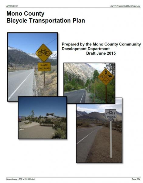
TABLE OF CONTENTS
Summary.
Chapter 1: Introduction. 233
Chapter 2: Needs Assessment 237
Chapter 3: Policies. 246
Chapter 4: Demand for Bicycle Facilities. 254
Chapter 5: Proposed Bikeway System.. 260
Chapter 6: Funding, Implementation, and Phasing. 268
Appendix A: References. 271
Appendix B: Emails from Bicycling Groups. 273
Appendix C: Maps. 277
TABLE OF TABLES
TABLE 1. Required Components of a Bicycle Transportation Plan. 232
TABLE 2. Mono County Population Estimates, 2015. 255
TABLE 3. Mono County Population Projections, 2020-2040. 255
TABLE 4. Mono County Community Population Projections, 2010-2040. 256
TABLE 5. Travel Time to Work, Workers 16 & Older by Planning Area, Mono County, 2000. 258
TABLE 6. Potential Projects. 262
TABLE 7. Estimated Costs for Potential Bikeway System.. 268
TABLE 8. Past Expenditures on Bicycle Facilities. 269
TABLE OF FIGURES
FIGURE 1. Examples of Bikeway Types in Mono County. 240
FIGURE 2. Example of Bicycle-friendly Cattle Guard on Benton Crossing Road. 242
FIGURE 3. Antelope Valley Bike Facilities Map. 278
FIGURE 4. Bridgeport Valley/Twin Lakes Bike Facilities Map. 279
FIGURE 5. Bridgeport Community Bike Facilities Map. 280
FIGURE 6. Lee Vining Community Bike Facilities Map. 281
FIGURE 7. June Lake Loop Bike Facilities Map. 282
FIGURE 8. Long Valley Bike Facilities Map. Error! Bookmark not defined.
FIGURE 9. Benton Community Bike Facilities Map. 284
Summary
Caltrans Bicycle Transportation Account (BTA) Cross-Reference
Prior to the Active Transportation Program (ATP), a Bicycle Transportation Plan (BTP) was required for county’s to qualify for funding from the state Bicycle Transportation Account (BTA) administered by the Caltrans Bicycle Facilities Unit (BFU). The BTA has since been integrated into the ATP, but this BTP continues to comply with the required components from California Streets and Highway Code Section 891.2. Eventually, the BTP may be integrated into a Mono County ATP Plan. The Mono County Bicycle Transportation Plan includes each of the required components, as follows:
TABLE 1. Required Components of a Bicycle Transportation Plan
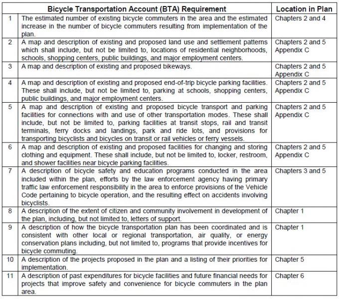
Chapter 1: Introduction
Purpose of Plan
The Mono County Bicycle Transportation Plan is the bicycle transportation plan for the unincorporated area of Mono County. The only incorporated area in Mono County, the Town of Mammoth Lakes, has its own Bicycle Transportation Plan and thus it is not a part of this document. This Plan has been developed in compliance with California Streets and Highways Code Sections 891.2 and 891.4 and in compliance with the requirements for state Bicycle Transportation Account (BTA) funding applications. The Plan further develops the General Bikeway Plan contained in the Mono County Trails Plan (1994) and has been designed to complement similar plans in surrounding counties and communities. The Plan includes the following components:
- Describes existing bicycle facilities and programs in Mono County;
- Analyzes the need for future facilities and programs in the county;
- Designates new routes and prioritizes their development;
- Provides maps for existing and proposed bikeways;
- Establishes policies and standards for the improvement of bicycle facilities and programs; and
- Identifies funding sources and establishes implementation goals for prioritized projects.
Policies in the document recommend that the Mono County Bicycle Transportation Plan should be reviewed and updated every five years, in compliance with state requirements for Bicycle Transportation Account (BTA) funding and to ensure that the plan remains current.
Planning Area
Mono County is a sparsely populated rural county located on the eastern side of the Sierra Nevada mountain range. The State of Nevada forms the county's eastern border. Approximately 94 percent of the county's 3,103 square miles are publicly owned; the area's spectacular scenery of high valleys and rugged mountain ranges has made it a popular recreation destination. The major population center, and the County's only incorporated area, is the Town of Mammoth Lakes. The remainder of residents are scattered in small communities throughout the county.
Communities in the county include Topaz, Coleville and Walker in the Antelope Valley; Bridgeport, the County seat, in the Bridgeport Valley; Mono City and Lee Vining in the Mono Basin; June Lake along the June Lake Loop; Long Valley, McGee Creek, Crowley Lake, Aspen Springs and Sunny Slopes in Long Valley; Swall Meadows and Paradise in the Wheeler Crest area; and Chalfant, Hammil and Benton in the Tri-Valley area.
Mono County is a recreation destination. Throughout the year, there is a significant tourist population in many of the county’s communities and at various recreation destinations such as Mammoth Mountain Ski Area, June Mountain Ski Area, Mono Lake, and Bodie.
Mono County Highways
The state and federal highway system provides the major access to and through Mono County, connecting communities in the county and providing access to and from the county.
- US 395 is the major transportation route in the county. It connects the Eastern Sierra with Southern California and with the Reno/Tahoe region in Northern Nevada. US 395 is also Main Street in Lee Vining, Bridgeport, Walker, Coleville, and Topaz.
- US 6, from the Inyo County line north of Bishop to the Nevada state line, connects the Tri-Valley communities of Benton, Hammil, and Chalfant to Bishop and Inyo County. US 6 is also Main Street in the Tri-Valley communities.
- SR 89 provides access from US 395 to Monitor Pass and is closed in the winter.
- SR 108 provides access from US 395 west to Sonora Pass and is closed in the winter.
- SR 120 provides access from US 395 west to Tioga Pass and east to Benton. The western segment is closed in the winter and the eastern segment may also be closed briefly.
- SR 158, the June Lake Loop, provides access from US 395 to the community of June Lake and is Main Street throughout the June Lake Loop. A portion of SR 158 is closed in the winter.
- SR 167 provides access from US 395 to the Nevada State Line, north of Mono Lake, and access to the community of Mono City.
- SR 168 provides access from US 395 at Big Pine in Inyo County north to Oasis in the southeast corner of Mono County.
- SR 182 provides access from its junction with US 395 in Bridgeport northeast to the Nevada state line and provides the main street access to a portion of the community of Bridgeport.
- SR 203 provides access west from US 395 to Mammoth Lakes.
- SR 266 provides access through Oasis in the southeast corner of the county.
- SR 270 provides access east from US 395 to Bodie State Historic Park and is closed for a portion of the winter.
Mono County Roads
The County currently has 684.15 miles of county maintained roads. Of that maintained mileage, 179.07 miles are paved, 168.47 miles are plowed in the winter, and 197.87 miles traverse National Forest lands. Most of the County roadway system is already established, and the priority is on maintaining the existing circulation system. The need for new facilities are generally addressed in the community policy section (e.g. June Lake) in order to complete the circulation system, alleviate congestion and provide for continued growth. The main access to all communities in the county is state highways, i.e. Highways 395, 158, and 6.
In addition to County roads, there is an extensive network of private and federally controlled roads in the county, many of them unimproved. The federal roads, on lands managed by the Forest Service and Bureau of Land Management, are mostly unmaintained dirt roads that receive limited use from logging trucks, off-highway vehicles (OHVs), mountain bikers. The Forest Service and the BLM have developed management plans for OHV use. The private roads in the county are mostly in community areas and are either substandard roads that do not meet the County Roadway Standards and as a result have not been accepted into the County Roadway Systems, or newer roads established as a part of subdivision development that are maintained by entities such as County Service Areas that are funded by the landowners served.
The transportation systems serving the Bridgeport Indian Colony and the Benton-Paiute Reservation include county roads, tribal roads, and roads managed by the Bureau of Indian Affairs. Transportation needs for each location include road upgrades, ongoing road maintenance, and new road construction to serve existing and proposed development (see Bureau of Indian Affairs, Benton-Paiute Reservation Transportation Plan; Bridgeport Indian Colony Transportation Plan).
Community Participation in Plan Development
Community participation in the development of the Mono County Bicycle Transportation Plan was widespread. Comments received from the following sources have been incorporated into the plan.
Staff made presentations to the following groups to elicit comments on the plan:
- General Public: Staff made presentations at the county’s nine community and Regional Planning Advisory Committees seeking input. These local planning groups work with the county on a variety of planning and development issues. The groups are composed of local residents, along with some local representatives of federal and state agencies.
- Collaborative Planning Team: The Collaborative Planning Team is a multi-agency planning team, consisting of local, state, and federal agencies, which focuses on a variety of planning and resource use issues in the Eastern Sierra. Members include Mono County, the Town of Mammoth Lakes, the Bureau of Land Management, the Lahontan Regional Water Quality Control Board, the California Department of Fish and Game, Caltrans, the Los Angeles Department of Water and Power, the Inyo National Forest, the Humboldt-Toiyabe National Forest, the Benton Paiute Reservation, and the Bridgeport Indian Colony.
Staff contacted the following groups to elicit input on the plan:
- Schools: Eastern Sierra Unified School District and Mammoth Unified School District.
- Bridgeport Indian Colony.
- Benton Paiute Reservation.
- Bodie State Park.
- USFS: Inyo National Forest and Humboldt-Toiyabe National Forest.
- Bureau of Land Management: Bishop Office.
- Bike groups: East Side Velo Club and the Sierra Cycling Foundation.
Consistency with Local Plans
Caltrans
Mono County is located in Caltrans District 9, which operates and maintains all state and federal highways in the county. The district has a bicycle coordinator and a bicycle page on the district website that includes bicycle route maps for the area and route elevation profiles linked to the roadway map (see www.dot.ca.gov/dist9/).
Mono County General Plan
The Bicycle Transportation Plan (BTP) has been developed to be consistent with applicable policies in the Mono County General Plan Circulation Element. The Plan will be attached as an appendix to the Regional Transportation Plan, which is part of the Circulation Element of the General Plan.
Mono County Local Transportation Commission
The BTP has been developed to be consistent with applicable policies in the Mono County Regional Transportation Plan (RTP). The Plan will be attached as an appendix to the RTP.
Bureau of Land Management (BLM)
The BLM actively plans local and regional bikeways on federal lands under its jurisdiction in Mono County. Recreation planners focus primarily on mountain biking and hiking trails for recreational use. Trails and bikeways that could be used as connectors to communities have been incorporated into this plan.
US Forest Service (USFS)
The BTP has been developed to be consistent with applicable policies in the Land and Resource Management Plans for the Inyo National Forest and the Toiyabe-Humboldt National Forest, as well as the management plan for the Mono Basin National Forest Scenic Area.
Inyo County
The BTP has been developed to be consistent with applicable policies and maps in the Inyo County BTP.
Town of Mammoth Lakes
The BTP has been developed to be consistent with applicable policies and maps in the Town of Mammoth Lakes Draft Mobility Element and General Bikeway Plan (2014).
Chapter 2: Needs Assessment
This chapter provides information on existing bicycle facilities in Mono County, including regional and multimodal connections and support facilities and programs. It then identifies Needs and Opportunities for bicycle facilities and programs throughout the county.
Mono County Bikeway Facilities
The unincorporated area of Mono County, outside of the Town of Mammoth Lakes, has few existing bicycle facilities.
Existing Bicycle Routes and Signage
Although cycling is an increasingly popular activity in Mono County, the county lacks facilities specifically for bicyclists. Most cycling occurs on roadways where the shoulder may or may not be wide enough to accommodate bicyclists safely. Mountain bike use occurs throughout the county on dirt roads, which generally are not marked as bike trails. The following are the sections of local roads with markings/signage for bike use:
- Bike Route along Crowley Lake Drive and South Landing Road from Tom’s Place to Crowley Lake
- Bike Route along Pearson Road in Crowley Lake
- North Shore Drive Bike Route in June Lake
- Share the Road signs along Benton Crossing Road
- Share the Road signs along SR 158 in June Lake
- Bicycle/pedestrian bridge over the East Walker River in Bridgeport
- Recently designated bike lane on Main Street (Hwy 395) in Bridgeport
- Eastside Lane Bike Route in the Antelope Valley
Existing Rest Facilities
Rest facilities (e.g. restrooms, drinking water, public phones, and air for tires) and parking facilities (for vehicles and bicycles) are available in most communities at the community center, at private facilities in communities, at schools, at county parks, and at U.S. Forest Service facilities.
Outside of communities, rest facilities and parking facilities are available at U.S. Forest Service facilities (campgrounds and recreational areas), and at private recreational areas (e.g. Twin Lakes, Brown's Campground on Benton Crossing Road, etc.). There are few rest facilities on the many dirt roads in the county used by bicyclists. Most of those roads are on public lands and the applicable land management policy for those areas is generally to keep them as undeveloped recreational areas.
The Eastern Sierra Scenic Byway provides rest facilities along the length of US 395 in Mono County and along SR 120 between Yosemite National Park and US 395.
Existing Parking Facilities
- Bike racks are located at the following locations:
June Lake Library and Community Center
USFS Mono Basin Visitor Center in Lee Vining
Behind Mono Mart in LV for employees
County Annex building in BP
Lee Vining High School
Lee Vining Community Center
Changing Facilities
- No facilities specifically exist for bicycle riders to change clothing (changing facilities) except for restrooms adjacent to the bike racks mentioned above.
Transport Facilities/Public Transit Connections
- All Eastern Sierra Transit buses have bike racks. Shelters have recently been installed at bus stops in communities throughout the county, however, the shelters are not equipped with bike racks.
Bus shelters have been installed in the following locations:
- Crowley Lake Drive, just north of Tom’s Place store
- Community Center in Crowley Lake
- Chalfant at the Community Center
- Lee Vining, in front of the Caltrans Yard and on Hwy 120 at the Mobile Mart (this is a YARTS stop)
- Walker, US 395 southbound near the County Store
- Bridgeport, on Emigrant Street next to the County Park Tennis Courts
Mono County Bicycle Users
The unincorporated area of Mono County, outside of the Town of Mammoth Lakes, has few existing bicycle facilities. With job centers and school locations often outside their community, it is not practical for most people to commute to work on bicycles or for many students to commute to school using bicycles. Both students and workers must often drive many miles to their destination, to a community other than the one in which they reside. However, this gap appears to be closing. The 2009-2013 American Community Survey 5-year Estimate by the U.S. Census Bureau estimates just over a 16 minute mean travel time to work (http://factfinder.census.gov/faces/tableservices/jsf/pages/productview.xhtml?src=bkmk), indicating a more reasonable distance to commute by bicycle. Extreme weather conditions also make it difficult to bicycle year-round; snow and ice in many parts of the county limit winter biking opportunities, while extreme heat and dust storms decrease summer biking opportunities in other areas.
Interest in commuting by bicycle is growing within communities. There is generally limited traffic congestion, and air quality impacts from automobile use are minimal in the county. Bicycling within Mono County communities is a viable opportunity because most Mono County communities are small, with relatively flat topography. Opportunities for recreational bicycling are abundant. Many of the county’s paved roads have little traffic and lead to a variety of scenic recreational destinations.
The County currently has no estimates on the number of existing bicycle commuters in the area, nor the numbers of school children who ride to school. Anecdotal data suggests that numbers for both categories are small. The 2009-2013 American Community Survey 5-year Estimate by the U.S. Census Bureau does not provide a category for bicycle commuters, but does estimate that 13.9% of the population walk to work and 4.5% utilize other transportation means (see http://factfinder.census.gov/faces/tableservices/jsf/pages/productview.xhtml?src=bkmk).
Recreational Use/Bicycling Events
Recreational biking is an increasing tourist attraction in the County, both on county roads and highways and on unpaved roads on public lands. The local cycling community currently produces several large-scale bike event on roads within the County, including the Mammoth Gran Fondo, Everest Challenge, and Pamper Pedal, among others. The Sierra Cycling Foundation has indicated that organizers would like to attract more large scale biking events to the County.
Safety and Education Programs
Several entities within Mono County conduct bicycle safety and educational programs.
- The Mono County Health Department sponsors bicycle safety activities throughout the year in conjunction with other county and town agencies. There are a limited number of bicycle helmets available for children whose families cannot afford to buy one.
- The Town of Mammoth Lakes Police Department continues to have an ongoing program of bicycle safety and education primarily oriented toward elementary school-aged children. The program includes a yearly “Bicycle Rodeo” for all grades, bicycle inspection, bicycle safety handouts, and bicycle registration. The Bicycle Rodeo focuses on riding safety and instruction, helmet use, traffic sign recognition, bicycle lane use, handling cross-walks, hand signals, etc. Bicycles are checked for safety features such as seats, handlebars, brakes, and tires; a special sticker is issued showing inspection. The program is conducted on a yearly basis. Safety handouts are also available for younger children in the first and second grades.
- Sierra Cycling Foundation’s mission is to promote cycling and improve cycling conditions in the Eastern Sierra. SCF advocates bicycle safety and education of cyclists as well as motor vehicle operators. The group strongly supports the “share the road” concept and continually strives to add more miles of “share the road” signs. SCF provides bicycle safety information and suggested routes and rides for cyclists visiting and living in the Eastern Sierra and emphasizes bicycle-safety training for children, mandatory helmet laws, and safer road conditions by working with public works and planning departments in Inyo and Mono counties, the Town of Mammoth Lakes, the city of Bishop and Caltrans, District 9.
- Eastside Velo is a bicycle club registered with the United States Cycling Federation, with about 270 members in 2015. The club organizes rides and events, including the Mammoth Gran Fondo, and is an advocate for road biking in the Eastern Sierra.
Types of Bikeways
The Caltrans Highway Design Manual identifies four types of bicycle facilities:
- Class I Bikeway (Bike path). Separate right-of-way for bicyclists. Generally should serve corridors not served by streets or highways.
- Class II Bikeway (Bike lane). Utilizes the shoulder area of roads. Signing and striping separate areas for bicyclists and motorists.
- Class III Bikeway (Bike route). Similar to a Class II Bikeway, except that the shoulder area is shared with vehicles.
- Shared Roadway (No bikeway designation).
Most of the facilities in the county are Shared Roadways. There is a short Class II Bikeway along Crowley Lake Drive in the vicinity of Aspen Springs and on Bridgeport Main Street. There are also marked mountain bike routes on dirt roads in the western end of Long Valley.
Selection of the appropriate type of bikeway to meet an identified need is dependent on many factors, including safety, demand, and connection to other bike facilities. The Caltrans Highway Design Manual contains criteria to help determine whether designation of a bikeway is appropriate and, if so, which type is most suitable. The relative cost of various types of facilities is also a consideration.
In Mono County, shared roadways (with a 4-foot paved shoulder and 4-inch edge stripe) will continue to be the most feasible type of bikeway in most areas. Relatively low bicycle demand may make it infeasible to designate bikeways; environmental considerations and maintenance costs may make it difficult to develop separate bike paths.
Caltrans’ Requirements to Provide for Bicycle Use
Caltrans is required to provide adequate width for shared use by motorists and bicyclists on new construction and major reconstruction projects. On resurfacing projects, the entire paved shoulder and traveled way must be resurfaced and when adding lanes or turn pockets, a minimum 4-foot shoulder must be provided. These requirements will result (or has resulted) in the development and maintenance of a minimum 4-foot paved roadway shoulder with standard 4-inch striping on many portions of the highway system in Mono County.
Since highways in Mono County receive relatively limited use by bicyclists, it may be inappropriate to designate them as bikeways, particularly since Caltrans' requirements are resulting in adequate on-road facilities. However, special consideration should be given to the placement of rumble strips to better accommodate cyclist needs; the need for regular maintenance of shoulders to ensure safe riding conditions; and pavement surface in rehabilitation projects to ensure conditions suitable for cyclists.
Planning and Design Standards
The Caltrans Highway Design Manual establishes bikeway planning and design in California. Section 1001.2 of the Manual discusses the role of bikeways as “one element of an effort to improve bicycling safety and convenience – either to help accommodate motor vehicle and bicycle traffic on shared roadways, or to complement the road system to meet needs not adequately met by roads.”
Streets and Highway Code Section 890.4 defines a “bikeway” as a facility that is provided primarily for bicycle travel and identifies the three types of bikeways listed above: Class I, II and III bikeways (see Figure 1).
FIGURE 1. Examples of Bikeway Types in Mono County
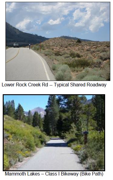
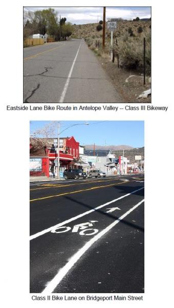
The Design Manual also notes a fourth type of bikeway facility – the Shared Roadway with No Bikeway Designation. Most bicycle travel in the state, and in Mono County, occurs on streets and highways without bikeway designations. The Manual (Section 1002.1) notes that:
Many rural highways are used by touring bicyclists for intercity and recreational travel. It might be inappropriate to designate the highways as bikeways because of the limited use and the lack of continuity with other bike routes. However, the development and maintenance of 4-foot paved roadway shoulders with a standard 4 inch edge line can significantly improve the safety and convenience for bicyclists and motorists along such routes.
Selection of the appropriate type of bikeway to meet an identified need is dependent on many factors, including safety, demand, and connection to other bike facilities. The Caltrans Highway Design Manual contains criteria to help determine whether designation of a bikeway is appropriate and, if so, which type is most suitable. The relative cost of various types of facilities is also a consideration.
Countywide Needs Identified by Local Bicycle Groups
Local bicycling groups, including Eastside Velo and the Sierra Cycling Foundation, have identified several overall needs related to biking in unincorporated Mono County.
- Uphill Bike Lanes
Widening uphill shoulders is the single most important step to achieve consistent auto flow travel, cycle safety and construction economics (build lanes uphill only). Widening uphill sections on the Scenic Loop, Crowley Lake Drive, Benton Crossing Road, lower and upper Rock Creek Road and Highway 120 would be a sensible, economical start.
- Maintenance
Existing roads and shoulders should be maintained. Expansion cracks need to be filled and smoothed with special attention to downhill lanes. Benton Crossing Road and the Scenic Loop are examples of downhill stretches of roads in need of crack filling.
- Cleanliness
Road shoulders should be swept, with uphill sections swept most frequently. Uphill roads with banks and curbs need vacuum-type sweeping rather than pull-broom as the banks trap debris. Major holidays yield more glass and debris.
- Signage
Signs, which indicate cycle traffic, give a heads-up to both cyclists and motorists. "Share the Road" signs on 2-lane roads are an inexpensive yet effective way to create safety for all. "Share the Road" signs would be well suited for the Scenic Loop, Crowley Lake Drive, Twin Lakes Road and Benton Crossing Road. Bike Route signs on SR 203, and on US 395 from Tom's Place to June Lake and eventually to Lee Vining would be ideal.
- Rumble Strips
The size and placement of rumble strips, and resulting safety issues, are a concern. The Sierra Cycling Foundation (SCF) explains that the current placement of rumble strips forces bicyclists onto a dirty shoulder, and advocates for a rumble strip half its current width and placed immediately to the right of the fog line (see http://www.sierracyclingfoundation.org/positions.htm). SCF also advocates for regular maintenance and sweeping of the shoulder.
- Bicycle-friendly Features
In addition to signage, street features should be planned to accommodate bicyclists. For example, the wider plates on cattle guards on Benton Crossing Road enable bicyclists to cross safely (see Figure 2).
FIGURE 2. Example of Bicycle-friendly Cattle Guard on Benton Crossing Road.
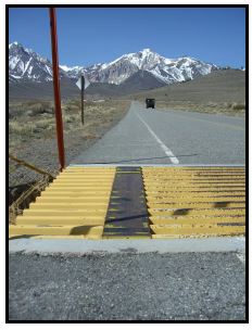
Community Needs
Antelope Valley- Antelope Valley has several small communities spread out along the perimeter of the valley. Bicyclists currently use local highways and roadways to move between those communities and through the valley. These roadways are adequate to serve current and future cyclist demand but safety could be improved by widening the shoulders of the roadways and by striping/signage.
- Antelope Valley is separated from the rest of the county by topography. It does not have any nearby recreational destinations popular with cyclists. Opportunities may exist to promote cycling through the Walker Canyon via the Scenic Byway planning effort.
- The Death Ride is held each year that includes a stretch traveling over Monitor Pass to Hwy 395 and back. There may be an opportunity to coordinate efforts with Alpine County to build upon the success of an event that had 3,500 riders in 2012.
- Swauger Creek/Devil's Gate is an isolated residential area where the provision of bikeways has not been an issue.
- Bridgeport needs safe commuter routes for children and others from the Evans Tract and the residential areas on SR 182 to the Main Street area and the school. These could be provided by widening the shoulders and designating a bike route or by designating an alternative route.
- Residents have expressed an interest in developing a bike route between Bridgeport and Twin Lakes, a popular cycling route, either by widening the shoulders on Twin Lakes Road or by creating a separate bike path that parallels Twin Lakes Road. Both alternatives, especially the second, might encounter wetlands which would make development difficult. In addition, a separate bike path would require obtaining easements or rights-of-way, which could be expensive and make the project infeasible.
- Residents are also interested in eventually developing a loop trail connecting the Twin Lakes bike trail to Buckeye Canyon Road and linking that segment to a trail around the reservoir.
- The Bridgeport Main Street planning effort developed and implemented Class II bike lanes through the townsite, establishing an opportunity for additional bicycle connectivity to SR 182 and Twin Lakes Road.
- Mono Basin has a number of dirt roads within the boundaries of the Mono Basin National Forest Scenic Area. Use of those roads is governed by the Comprehensive Management Plan for the Scenic Area, which allows cycling on existing roads.
- US 395 along the west side of Mono Lake does not have adequate shoulders in some areas for safety. Past efforts to expand shoulders were controversial, and the project has since been abandoned by the LTC and Caltrans.
- Major recreational destinations include Mono Lake, the Forest Service Visitor Center, Lundy Canyon, and SR 120/Lee Vining Canyon. Consider connecting these destinations via bike routes.
- Most children at the schools in Lee Vining are bussed to school or walk. Commuting routes for school children are limited.
- Policies in the June Lake Area Plan focus on creating a more inviting and walkable community, and providing alternatives to automobile use. The June Lake Multimodal Plan addressed these concerns, and has since been incorporated directly into the Regional Transportation Plan.
- The main bike route to and through June Lake is SR 158, a narrow, winding route without sufficient shoulders. This is an extremely popular touring route. Safety on this route is a high concern, particularly for cyclists between June Lake Village and the Down Canyon area.
- Public lands surrounding the June Lake Junction, and between June Lake and Mammoth Lakes, contain an extensive system of roads used by mountain bicyclists and off-highway vehicles. There are opportunities to link community bikeways to those roads. In addition, an alternative route parallel to US 395 could be investigated between June Lake and Lee Vining. The USFS continues their effort to highlight routes and eliminate duplicative paths of disturbance.
- Parking facilities for bicycles are limited in June Lake. Additional facilities could be provided in the Village and at the lakes.
- Share-the-road signs along North Shore Drive have been placed to enhance bicycle safety and use, and there is an opportunity to integrate cycling amenities at the Rodeo Grounds/West Village and plan bike paths to access the June Lake Ballfield, parks, and the lakes.
- The western portion of Long Valley is primarily a recreational area. There is no year-round residential development in the area. The area contains an extensive dirt road system, which is mapped in the Interagency OHV Maps. The Inyo National Forest has signed a few roads north of Casa Diablo and north of Mammoth Lakes as bike trails. Maps of those trails are available from the Forest. This is a very popular area with cyclists; additional trail markings may be appropriate.
- There is a potential to connect trails in Mammoth Lakes with trails to the surrounding area by signing existing roads as bike trails.
- The Long Valley area includes the communities of Sunny Slopes/Tom's Place, Aspen Springs, Crowley Lake/Hilton Creek, McGee Creek, and Long Valley. These residential communities have limited commercial activities. Many of the residents work in Mammoth; most of the children go to school in Mammoth.
- Crowley Lake Drive, from Tom's Place to Long Valley, is used for biking by both residents and visitors. The County constructed a bike path along Crowley Lake Drive, from South Landing Road to the Community Library and Park.
- There are a number of recreational areas popular with bicyclists in and adjacent to Long Valley, i.e. Rock Creek Canyon, Owens Gorge Road, Convict Lake Road, and Benton Crossing Road. Rock Creek Canyon and Owens Gorge Road are accessible from the community areas along Crowley Lake Drive. Convict Lake Road and Benton Crossing Road are not accessible except by riding on US 395. Residents are interested in providing alternative routes to US 395. The Interagency OHV Maps show that an alternative route from Crowley Lake to the Convict Lake Road would be possible. An alternative route to Benton Crossing Road would not be possible. Improvements to Rock Creek Road are being completed in 2015, including new pavement surface, bridge rehabilitations, and the addition of a bicycle climbing lane.
- Benton Crossing Road is extremely popular with residents and visitors for cycling. The Circulation Element/RTP contains a policy to designate a bike trail around Crowley Lake on Benton Crossing Road.
- The Circulation Element/RTP also contains a policy to designate a bike trail from Long Valley to Mammoth Lakes. Currently riders must use US 395. A loop from Mammoth Lakes to the Crowley area is another extremely popular cycling route.
- Wheeler Crest and Paradise are somewhat isolated residential areas. The only access road through the area, Lower Rock Creek Road, provides an alternative route to travel on US 395 between Long Valley and Bishop, as well as access to recreational areas along Lower Rock Creek. Lower Rock Creek Road is a narrow, 2-lane road. Residents are interested in providing a bikeway along Lower Rock Creek Road from the Inyo County line to Tom’s Place / Crowley Lake Drive.
- There are limited rest facilities along Lower Rock Creek Road.
- Lower Rock Creek Road is a significant attraction for road bicyclists, and for mountain bikers who utilize the biking/hiking trail adjacent to the road. A staging area is located at the southern end of the trail along the road near the Inyo County line.
Tri-Valley
- Bicyclists utilize SR 120 and SR 6 in the Tri-Valley area (Benton, Hammil, and Chalfant) for touring or long day trips. Increased safety on those roads is a concern.
- Limited rest facilities (restrooms, water) are located at the community parks in Benton and Chalfant. There are no official turnouts along SR 120 and SR 6.
- Chalfant has become a bedroom community for the City of Bishop, approximately 12 miles south in Inyo County. Residents have expressed an interest in developing a bike route between Chalfant and Bishop, either by widening the shoulder of SR 6 or by developing an alternative route. Although many residents of Chalfant commute to Bishop to work, the potential for commuter bicycle use is not high. The distance involved, extreme hot and cold weather conditions throughout the year, and heavy winds do not make commuting by bicycle particularly attractive.
- There is a need for safe bike routes. These could be provided by widening the shoulders and designating a bike route or by designating an alternative route, particularly on Chalfant Road and Valley Road.
- Recreational bicycle use of the Tri-Valley area is limited. There is some interest in developing a bike route to Fish Slough. Another potential bike route is Chalfant Loop Road, connecting Chalfant with White Mountain Estates.
- Oasis is an isolated agricultural area where the provision of bikeways has not been an issue.
Chapter 3: Policies
The following goals, policies and programs provide specific direction for the planning and implementation of bicycle facilities in Mono County. The policies have been developed to be consistent with, and complementary to, policies in the Mono County Circulation Element, the Mono County Regional Transportation Plan, the Inyo County Collaborative Bikeways Plan, and the Town of Mammoth Lakes Mobility Plan.
Countywide System
Goal 1. Develop a cohesive regional and community bikeway system that provides safe and convenient access to all communities and recreational opportunities in Mono County.
Policy 1.A. Maintain a Bikeway Master Plan that identifies existing and future needs, and provides specific recommendations for facilities and programs including adequate provisions for bicycle use to, within, and from Mono County.
Action 1.A.1. Review the Mono County Bicycle Transportation Plan biannually and revise as necessary.
Policy 1.B. Develop a system of community bikeways that connect commercial, recreational and residential areas in communities and that link communities to regional bike routes.
Policy 1.C. Designate regional bike routes that connect communities and that allow for regional travel to, within, and from Mono County.
Policy 1.D. Require all bikeways to conform to design standards contained in the latest version, of the Highway Design Manual, Chapter 1000: Bikeway Planning and Design Caltrans, unless otherwise established by the County.
Policy 1.E. Consider a proposed route's importance in providing access and connectivity to adjacent bikeway facilities and destinations when recommending bike routes for implementation.
Action 1.E.1. Coordinate with the Town of Mammoth Lakes, Inyo County and other governmental entities to ensure consistency with existing and planned bikeway systems.
Policy 1.F. Integrate bicycle planning with other county and community planning, including land use and transportation planning.
Action 1.F.1. Seek opportunities for Federal, State, County and Town joint participation, when appropriate, in the construction and maintenance of bikeways and associated facilities.
Action 1.F.2. Work with community groups and local cycling groups on the development and maintenance of bikeways and associated facilities.
Action 1.F.3. Work with appropriate agencies and organizations to obtain funding for bikeways development.
Commuting
Goal 2. Develop and implement a bikeway system that facilitates commuting to work, businesses, and schools.
Policy 2.A. Develop safe and convenient bikeway routes and facilities for all schools in the county.
Action 2.A.1. Implement the school bicycle routes contained in this plan.
Action 2.A.2. Ensure that funding remains available to maintain bicycle routes on an ongoing basis.
Action 2.A.3. Work with school districts, Caltrans, and the County to develop safe crossings, in order to minimize conflicts between bicyclists and vehicles near school.
Action 2.A.4. Work with school districts to obtain and install safe and convenient bicycle parking facilities at schools.
Action 2.A.5. Continue to implement ongoing safety programs that educate school children in safe bicycle riding.
Action 2.A.6. Pursue Safe Route to School funding for appropriate projects.
Action 2.A.7. Ensure that developers of large-scale projects within commuting distance of a school provide bikeways within the development.
Policy 2.B. Develop safe and convenient bikeway routes and facilities to employment centers throughout the county.
Action 2.B.1. Implement the commuting bicycle routes contained in this plan.
Action 2.B.2. Ensure that funding remains available to maintain bicycle routes on an ongoing basis.
Action 2.B.3. Work with Caltrans and the County to develop safe crossings, in order to minimize conflicts between bicyclists and vehicles in community areas.
Action 2.B.4. Work with local agencies, businesses and community groups to provide additional bicycle parking facilities in community areas.
Action 2.B.5. Work with the County to install safe and convenient bicycle parking facilities at County facilities.
Action 2.B.6. Encourage employers to provide bicycle commuter amenities (secure bicycle storage, changing facilities).
Action 2.B.7. Ensure that developers of large-scale projects provide bikeways connecting to existing local bikeways and/or access to community facilities and services (e.g. employment, shopping and services, recreational areas).
Policy 2.C. Where possible, develop commuting routes as part of multimodal facilities.
Action 2.C.1. Where applicable, develop multi-use routes that serve the needs of multiple users.
Action 2.C.2. Work with the County and local transit providers to install bicycle parking facilities at all bus stops.
Action 2.C.3. Work with local transit providers to ensure that all local and regional busses have bicycle racks.
Action 2.C.4. Consider installing bicycle parking at all airports in the County.
Policy 2.D. Identify community bike routes and commuting routes in order to increase usage and safety.
Action 2.D.1. Work with local agencies, businesses and community groups to develop and distribute maps depicting community bikeways.
Action 2.D.2. Develop and implement a uniform signage program to identify community bikeways and to direct bicyclists to public rest and parking facilities (at community centers, county parks, etc.).
Recreational Use
Goal 3. Develop and implement a bikeway system that supports bicycle-oriented recreation.
Policy 3.A. Support mountain biking opportunities within the Eastern Sierra.
Action 3.A.1. Work with land management agencies to identify mountain biking opportunities on existing roads on public lands.
Action 3.A.2. Develop and implement a uniform signage program to identify mountain biking routes and to direct bicyclists to biking facilities (parking, restrooms, etc.).
Action 3.A.3. Work with Caltrans, the Town of Mammoth Lakes, Inyo County, the Collaborative Planning Team, land management agencies, local biking groups, and other interested entities to develop promotional materials (printed, video, online) that highlight biking opportunities in the Eastern Sierra.
Action 3.A.4. Work with local agencies, businesses and community groups to develop and distribute maps depicting mountain biking routes.
Policy 3.B. Support on-road bicycle touring opportunities within the Eastern Sierra.
Action 3.B.1. Work with local biking groups to identify bicycle touring opportunities within the Eastern Sierra.
Action 3.B.2. Develop and implement a uniform signage program to identify bicycle touring routes and to direct bicyclists to biking facilities (parking, restrooms, etc.).
Action 3.B.3. Work with Caltrans, the Town of Mammoth Lakes, Inyo County, the Collaborative Planning Team, land management agencies, local biking groups, and other interested entities to develop promotional materials (printed, video, online) that highlight biking opportunities in the Eastern Sierra.
Action 3.B.4. Work with local agencies, businesses and community groups to develop and distribute maps depicting touring routes.
Policy 3.C. Support bicycling events in the Eastern Sierra, including organized tours, races, century rides, and similar events.
Action 3.C.1. Work with local biking groups to identify and support organized bike events.
Action 3.C.2. Plan and implement County and Caltrans road maintenance activities in order to provide the best possible experience for on-road events.
Policy 3.D. Provide additional facilities to encourage and promote recreational bicycle use within the Eastern Sierra.
Action 3.D.1. Work with appropriate entities to ensure that the County’s recreational destinations provide facilities for bicyclists, including parking.
Action 3.D.2. Work with land management agencies and the County to develop facilities that provide for touring bicyclists (e.g. campsites with bicycle parking facilities) at existing campgrounds.
Action 3.D.3. Ensure that informational kiosks along highways provide information on bicycle routes in the Eastern Sierra.
System Planning, Design, and Implementation
Goal 4. Implement land use and transportation planning, funding, and design practices that support bicycling.
Policy 4.A. Planning for all types of bicycling shall be a high priority in the existing land use and transportation planning process.
Action 4.A.1. The County’s CIP shall include bicycling improvement projects.
Action 4.A.2. Consider amending the County’s Land Development Regulations to include requirements for the provision of bicycling facilities in new development and redevelopment.
Action 4.A.3. Consider amending the County’s Road Standards to clarify requirements for the provision of bicycling facilities on county roads.
Action 4.A.4. Development or improvement to bikeways, in many cases, will be dependent on roadway improvements. Consult with Caltrans, the Mono County Department of Public Works, and the Forest Service concerning schedules for roadway improvements. Ensure that bikeway needs are considered/included during planning of roadway improvements (rehabilitation, maintenance, widening).
Action 4.A.5. Include bikeway facilities in appropriate local, state, and federal agency development projects.
Action 4.A.6. Development of bikeways on county roads should be consistent with goals and policies for bikeways development and recreational use on adjacent public lands.
Action 4.A.7. Provide input to Federal and State agencies on the development of bike routes on public lands.
Policy 4.B. Design bikeways to provide a safe, efficient, multimodal, well-connected system.
Action 4.B.1. Work with appropriate agencies to develop bikeways and associated facilities that connect to existing trail systems.
Action 4.B.2. When possible, plan and develop bikeways as multi-use year-round facilities.
Action 4.B.3. Where possible, develop bike routes to allow for future connections to an expanded transit system.
Action 4.B.4. Provide developed bikeways and facilities on the most heavily used routes in the County. Maintain the semi-primitive recreational experience in other areas.
Action 4.B.5. Ensure that new and existing bikeways conform to the latest design standards.
Maintenance
Goal 5. Maintain bikeways to provide safe riding conditions.
Policy 5.A. Maintain all bikeways (both on roads and separated bikeways) regularly to provide a safe riding surface.
Action 5.A.1. Sweep roadways as frequently as feasible to keep bicycle travel areas free of debris, including during winter months, as necessary.
Action 5.A.2. Encourage Caltrans to budget for highway maintenance and the maintenance of bicycle facilities, to the highest degree possible.
Action 5.A.3. Ensure that accident debris is removed from the entire roadway, including bicycle lanes, as soon as feasible.
Action 5.A.4. Correct safety concerns on area roadways, such as hazardous rumble strips and inadequate shoulders, through ongoing road maintenance and rehabilitation programs, when feasible.
Action 5.A.5. Maintain bike lane striping and pavement markings, to ensure continued legibility.
Safety Education
Goal 6. Create a safe environment for all bicycle users.
Policy 6.A. Educate bicyclists on how to ride safely.
Action 6.A.1. Work with school districts and the County Office of Education to ensure that all schools provide bicycle safety programs.
Action 6.A.2. Work with local cycling groups to provide safety programs for adults.
Action 6.A.3. Work with local cycling groups to provide safety information for visitors to the area.
Action 6.A.4. Pursue funding opportunities for bicycle safety programs.
Policy 6.B. Educate motorists about sharing the road with bicyclists.
Action 6.B.1. Provide additional share the road signs throughout the County.
Action 6.B.2. Include information about bicycle safety at all informational kiosks along highways.
Policy 6.C. Coordinate bicycle safety efforts among affected local agencies/entities.
Action 6.C.1. Encourage Caltrans District 9 to expand its bicycle webpage and to provide safety information on that webpage, as well as a means of reporting safety and maintenance issues on highways.
Action 6.C.2. Work with Caltrans, the Town of Mammoth Lakes, Inyo County, the Collaborative Planning Team, land management agencies, local biking groups, and other interested entities to develop safety materials (printed, video, online) that specifically address biking opportunities in the Eastern Sierra.
Funding
Goal 7. Ensure that funding is available to develop bikeways and facilities in Mono County.
Policy 7.A. Fiscal analyses for proposed bikeways development projects should consider both construction and maintenance costs.
Policy 7.B. Funding efforts should focus on developing community bikeways and associated facilities. Within communities, focus funding efforts on proposed bikeways where bicyclist demand is highest, safety concerns are greatest, and where roadway improvements will not necessarily improve biking conditions.
Policy 7.C. Countywide funding priorities for bikeways development should be established in the Capital Improvement Program (CIP) for Mono County.
Action 7.C.1. The County shall include applicable bikeways development projects identified in this Plan in its Capital Improvement Program (CIP).
Policy 7.D. Pursue all funding options for bicycle facility construction and maintenance.
Action 7.D.1. Utilize the CIP to identify proposed projects for applicable bicycle funding sources, such as the California Bicycle Transportation Account (BTA).
Action 7.D.2. Pursue funding from the BTA and Safe Schools Program to complete identified priority projects.
Action 7.D.3. Include proposed bikeways in roadway improvement projects whenever possible.
Action 7.D.4. Use existing funding as matching funds for state and federal funding.
Policy 7.E. Develop a strategic plan in consultation with Federal, State, and local agencies for coordinating and applying for bikeways funding.
Action 7.E.1. Prepare joint applications for bikeways projects, whenever possible.
Policy 7.F. Revise funding priorities annually, to reflect changes in funding availability and local and regional needs.
Action 7.F.1. Update funding information annually, including available programs for bikeway facilities, specific funding requirements, and deadlines.
Community Policies
Community Policies for Bikeways Development
Community policies were not developed for areas with little or no bicycle use and no identified issues (i.e. Swauger Creek/Devil's Gate and Oasis), or for areas with primarily regional routes (Mammoth Vicinity/Upper Owens, Wheeler Crest/Paradise).
Goal 8. Support bicycling safety, connectivity and facilities based on the needs in individual communities.
Antelope ValleyPolicy 8.A. Develop a loop bikeway route in the Antelope Valley by widening the shoulders on designated portions of US 395, Topaz Lane, Cunningham Lane, Larson Lane, and Eastside Lane.
Policy 8.B. Develop one or more informational kiosks along the loop route that discuss the Valley's history and natural setting.
Bridgeport ValleyPolicy 8.C. Develop a bikeway along SR 182 from the reservoir to town and along US 395 from the Evans Tract to town.
Policy 8.D. Develop a bike route from Bridgeport to Twin Lakes by widening the shoulder along Twin Lakes Road.
Policy 8.E. Provide interpretive signing in the Bridgeport Valley that discusses the Valley's ranching history, natural setting, and how to avoid potential user conflicts and resource damage.
Policy 8.F. Work with the Forest Service to develop a signed bike route along Timber Harvest Road and Reservoir Road.
Policy 8.G. Provide additional signage in Bridgeport directing cyclists to rest facilities at the park.
Policy 8.H. Provide increased recreation opportunities for mountain biking enthusiasts.
Policy 8.I. For trails connecting residential and recreational areas, consider multi-use trails capable of accommodating many modes of transportation.
Mono BasinPolicy 8.J. Work with Caltrans to develop a safe bike route on US 395 along the west side of Mono Lake from Lee Vining to the County park.
Policy 8.K. Work with appropriate agencies to develop a bike trail from Lee Vining to the campgrounds in Lee Vining Canyon, utilizing existing roads where possible.
Policy 8.L. Continue community conversations to consider a bike trail connecting Mono City to Lundy Canyon which, in concert with Policies 8.J. and 8.K., connect Lundy Canyon to the County park, Mono City, Lee Vining, and Lee Vining Canyon.
Policy 8.M. Work with community groups and businesses to provide additional bike racks in Lee Vining.
Policy 8.N. Provide signage in Lee Vining to direct cyclists to rest facilities at the park.
June Lake LoopPolicy 8.O. Develop bike routes in June Lake in conformance with the June Lake policies in the Regional Transportation Plan.
Policy 8.P. Link the bike routes in June Lake to popular recreational areas surrounding the June Lake Loop.
Policy 8.Q. Work with community groups and businesses to provide additional bike racks in the June Lake Village, at the marinas, and at the parks.
Long Valley
Policy 8.R. Provide community bike paths in Crowley Lake as follows:
- Widen shoulders along Crowley Lake Drive from Tom's Place to Long Valley, to provide for bicycle safety (tie to resurfacing of Crowley Lake Drive);
(Note: Sections of this route should be prioritized)
- Widen shoulders along South Landing Road, from Crowley Lake Drive to Crowley Lake, to provide for bicycle safety (this requires acquiring the right-of-way from Lakeview Subdivision north);
Policy 8.S. Work with Caltrans and the Forest Service to develop and implement standardized signing for bike routes on Sherwin Creek Road, Owens Gorge Road, and Substation Road.
Policy 8.T. Work with community groups and businesses to provide bike racks at appropriate places in Crowley Lake.
Wheeler Crest/ParadisePolicy 8.U. Provide a bikeway along Lower Rock Creek Road (e.g. bicycle climbing lane from the Inyo County line to Tom’s Place/Crowley Lake Drive)
Policy 8.V. Work with community members prior to the development of new trail planning efforts.
Policy 8.W. Work with the community, user groups and the BLM to maintain and improve Lower Rock Creek Trail (e.g. volunteer work days, wayfinding, etiquette and/or additional user facilities).
Tri-ValleyPolicy 8.X. Work with the Forest Service to develop a bike route to Fish Slough and to provide interpretive signing at Fish Slough.
Policy 8.Y. Improve signage directing cyclists to rest facilities at parks in Benton and Chalfant.
Chapter 4: Demand for Bicycle Facilities
Current and future demand for bicycle facilities in Mono County is difficult to measure or project since the County has no data on bicycle trips other than the extremely limited data from the 2000 Census. The 2010 Census does not provide any information on estimated number of bicycle trips in Mono County. The following sections analyze existing and future bicycle demand in relationship to the County’s overall goal of developing a cohesive regional and community bikeway system for Mono County.
Land Use Patterns
A general pattern of development recurs throughout the County. Development is concentrated in small communities located along US 395 or SR 6 (with the exception of Wheeler Crest and Paradise); recreational uses are dispersed throughout the county. Most of the limited amount of private land in the county is located in community areas. Public lands (94 percent of the land in the county) generally remain as open space and are used for a variety of recreational uses, including biking.
Most of the development in the county is low density; the most intense development occurs in the Town of Mammoth Lakes. Communities generally have a small commercial area surrounded by low-density residential development. Some communities (June Lake, Lee Vining, Bridgeport, Crowley Lake) have limited numbers of multiple family housing units mixed in with their commercial uses.
The Town of Mammoth Lakes is the major activity center in the county. Most of the services available in the county are provided there, along with the majority of shopping opportunities. Limited services, including schools, are available in some communities in the unincorporated area, primarily in Bridgeport where government offices are located. Several recreational destinations, such as Mono Lake and Bodie State Historic Park, have visitor centers and a definite center of activity. Many of the county’s other recreational destinations are dispersed with no defined activity center.
Bicycle Demand
Demand for bicycle facilities in Mono County falls into four categories:
- Bicycle routes for residents and visitors for alternate transportation and commuting between camping areas, day use areas, commercial areas, and businesses and employment.
- Bicycle routes for residents and visitors to Mono County for recreational use, sightseeing, and exercise.
- Safe bicycle routes in each community for children commuting to and from school and other activities.
- Safe bicycle routes for long distance riders on state and local highways and roadways.
There is currently limited demand by residents for commuting routes; this is unlikely to change. Land use patterns in the County have created a situation where it is not practical for most people to commute to work on bicycles or for many students to commute to school using bicycles. Both students and workers must often drive many miles to their destination, to a community other than the one in which they reside. Extreme weather conditions also make it difficult to bicycle year-round; snow and ice in many parts of the county eliminate winter biking opportunities, while extreme heat and dust storms decrease summer biking opportunities in other areas. Depending on the destination, safety considerations may eliminate the possibility of biking within communities. Many access routes in communities are either along highways or cross highways, often without adequate shoulders.
Increasing safety within communities and between communities and providing connections between Mammoth Lakes and surrounding communities would increase bicycling opportunities and demand.
Recreational use continues to increase. There is a need for a variety of recreational biking opportunities, ranging from short paved paths appropriate for family biking experiences, to long distance touring routes, and off-road experiences. When designating bike routes, it is important to remember that recreational users are looking for that variety.
Population Projections
Mono County’s population in 2007 was estimated to be 14,625 persons; 8,275 persons (60 percent) in Mammoth Lakes and 6,250 persons (40 percent) in the unincorporated portion of the county (see Table 1). The percentage of the overall population that lives in Mammoth Lakes has increased slightly since 2000.
TABLE 2. Mono County Population Estimates, 2015
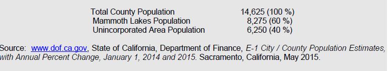
Table 2 shows population projections for the county for the next 25 years. It includes the percent of the population over the age of 15 as an indicator of the number of people who may be commuting and the percent of the population aged 15-69 as an indicator of the number of people most likely to be commuting. Over the next 25 years, the percentage of the population older than 15 is expected to remain stable at 84 percent while the percentage of the population aged 15-69 is expected to decrease slightly as the population ages.
TABLE 3. Mono County Population Projections, 2020-2040
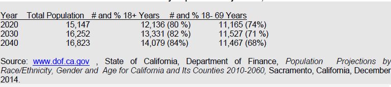
Table 3 shows population projections by community areas through the year 2040. The community projections are based on the following assumptions: that the unincorporated area will continue to house approximately 43 percent of the total countywide population and that the population distribution in the unincorporated community areas will remain similar to the population distribution in 2010. The last assumption may not hold true. Antelope Valley is experiencing increasing development pressures from the Gardnerville/Carson City area; Chalfant is experiencing a similar pressure for expansion from the Bishop area; and Benton, Chalfant, and the Long Valley communities are experiencing continuing pressure from residents who work in Mammoth. As housing prices continue to rise in Mammoth Lakes, other areas of the county may experience increasing development pressure.
It is important to note that the population projections shown in Table 3 are for permanent year-round residents. Mono County, and particularly community areas such as Mammoth Lakes and June Lake, experiences much higher peak populations during periods of heavy recreational use, a factor that has a direct impact on the transportation system. Projected peak populations are utilized to determine transportation/travel demand in Mammoth Lakes and June Lake.
TABLE 4. Mono County Community Population Projections, 2010-2040
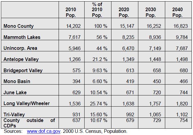
Land Use Forecasts
Development in Mono County communities is primarily residential with limited small-scale commercial uses serving local and tourist/recreational needs. Limited small-scale light industrial uses, such as heavy equipment storage and road yards, also occur in some county communities. Most communities also have public facilities such as schools, libraries, community centers, parks and ballfields, and government offices (in Bridgeport). This development pattern is not anticipated to change, due to the small scale of communities in Mono County, the limited private land base for expansion, and the lack of employment opportunities in most communities.
The Land Use Element of the County's General Plan contains policies that focus future growth in and adjacent to existing communities. Substantial additional development outside of existing communities is limited by environmental constraints, the lack of large parcels of privately owned land, and the cost of providing infrastructure and services in isolated areas. Land use policies for community areas in the county (developed by the county’s citizens regional planning advisory committees) focus on sustaining the livability and economic vitality of community areas. The General Plan anticipates that growth in the unincorporated area will occur primarily in the Antelope Valley, Bridgeport Valley, June Lake, Wheeler Crest/Paradise, the Tri-Valley, and Long Valley.
Employment
Mono County's economy is dominated by services, retail trade and government. Industry projections from the California Employment Development Department for the Eastern Sierra Region estimate that job growth in the area between 2004 and 2014 will be strongest in Leisure and Hospitality Services, Government, Retail Trade, and Trade, Transportation and Utilities. Major job centers are located in Mammoth Lakes (services, retail trade, government), June Lake (seasonal services and retail trade) and Bridgeport (government). Despite the availability of Commercial (C) and Mixed Use (MU) zoning throughout communities in the unincorporated area, it is unlikely that sufficient jobs will develop to eliminate the need for workers to commute to jobs outside their communities.
Employment trends for the unincorporated area vary from the County as a whole, with higher percentages in agriculture, construction and mining (particularly mining), manufacturing, transportation and public utilities, and services, and lower percentages in wholesale trade, retail trade, finance, insurance, real estate, and government.
Employment data for September, 2009, from the Employment Development Department show the following current employment by industry (not seasonally adjusted):
Total Wage and Salary 6,280
Leisure and Hospitality 2,870
Government 1,650
Trade, Transportation and Utilities 600
Retail Trade 490
Goods Producing 390
Financial Activities 260
Professional and Business Services 240
Transportation, Warehousing and Utilities 100
Educational and Health Services 40
Manufacturing 40
Farm 20
Wholesale Trade 10
The following list of major employers in Mono County was developed using the 2009 America's Labor Market Information System Employer Database (California Employment Development Department, www.labormarketinfo.edd.ca.gov). Many of these employers are located in Mammoth Lakes, a significant commute from many areas of the County.
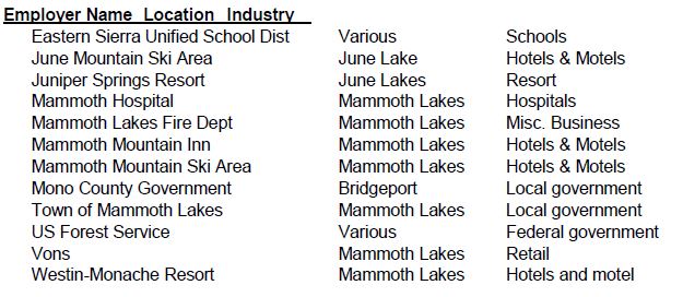
Place of Work
The 2009-2013 American Community Survey 5-year Estimate[1] indicated 99% of workers 16 years and older residing in unincorporated Mono County worked within the state and 91% worked within Mono County. These numbers indicate a significant increase in the jobs/housing balance over 2000, when only 75% worked in the state and county (US Census 2000, Summary File 3, Tables P 31 and P32). The mean travel time to work also decreased from less than 30 minutes in 2000 to just over 16 minutes in the 2009-2013 estimate. The primary means of transportation to work was a car, truck or van (67%). Of these, 54% were single-occupancy vehicles and 13% were carpools with two or more persons. Walking accounted for 14% of commuters, followed by public transportation (5%), bicycling (2.5%), and taxicab/motorcycle/other (2%). Workers from home constituted 10%.
The most recent data on travel times from communities to work locations is from the 2000 Census. The 2010 Census does not appear to provide this information. In 2000, travel times to work were highest in Antelope Valley and Tri-Valley, reflecting the fact that many residents of those areas work outside the community. A large number of Long Valley/Wheeler Crest workers commuted between 30 and 44 minutes, probably to Bishop or other points in Inyo County (see Table 4).
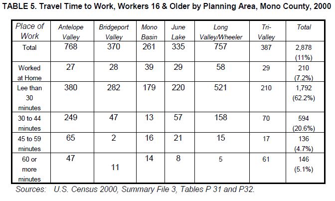
Future Demand
Future demand for bicycle facilities in Mono County is difficult to project since the County has no data on bicycle trips other than the extremely limited data from the 2000 Census. Data from the 2000 US Census show that only 3 out of 2,878 daily trips in the unincorporated area were made via bicycle (2000 US Census, SF3, P30), less than one percent of the total. In 2000, 298 daily trips to work were made by walking, approximately 10 percent of the total trips. The 2010 Census does not provide estimates on bicycle trips.
Many Mono County communities are small enough to allow commuting by bicycle. However, as discussed previously, many County residents do not work in the community in which they live. This is unlikely to change, since most communities are primarily residential with limited employment opportunities. Commuting between communities is difficult due to the distances involved, the terrain, and unfavorable weather conditions much of the year.
Enhancements to bicycle facilities within communities could increase the use of bicycles for commuting and trips to school. The development of additional bicycle facilities between community areas could increase commuting between certain communities when the weather is favorable.
Future demand for recreational bicycle use throughout the County is expected to continue. The development of additional bicycle facilities intended for recreational users and the continued enhancement of County roads and highways to provide an optimum experience for recreational users is expected to increase recreational cycling.
Chapter 5: Proposed Bikeway System
This chapter contains descriptions and maps of existing and proposed bicycle facilities and programs in Mono County. The criteria utilized to develop and prioritize the projects for the bicycle system are based on the information in prior chapters in this plan, i.e. Chapter 2: Needs Assessment, Chapter 3: Policies, and Chapter 4: Demand for Bicycle Facilities. As projects are more fully scoped and developed, adequate environmental documentation will also be developed to meet California Environmental Quality Act requirements.
Bicycle System Selection Criteria
The overall goal of this Plan is to “develop a cohesive regional and community bikeway system that provides safe and convenient access to all communities and recreational opportunities in Mono County.” In order to achieve this goal, the following criteria were utilized to develop the proposed bikeway system for the unincorporated areas of Mono County:
- The routes use existing roads and facilities where possible in order to provide the most cost effective bicycle system. New routes/facilities are considered when safety and convenience would be maximized by developing such routes and when the development of such routes would increase bicycle use.
- Proposed routes connect residential areas, schools, commercial areas, and local parks in order to develop community bicycle routes.
- The routes provide continuity with bicycle routes and trails in surrounding communities and counties, providing access to recreational destinations, in order to develop regional bicycle routes.
- The routes maximize multimodal connections within the County and to and from the County.
- Proposed bicycle routes and facilities maximize safety.
- Support facilities are included in the development of the system in order to maximize safety and convenience and to encourage additional use of the system.
- Educational/promotional programs are included in the development of the system in order to maximize safety and to encourage additional use of the system.
Proposed Bicycle Routes
Bike routes identified in this plan provide for:
- The commuting needs of employees, businesspersons, shoppers and students;
- Connection of community areas to local and regional recreational areas and existing trail systems;
- The needs of recreational bicyclists;
- Parking and rest facilities; and
- Multiple use of facilities where possible.
Popular touring routes traversing the entire county are included along with local routes focused in communities. Maps identifying both the regional routes and the community routes are shown on the following pages.
Proposed Support Facilities
- Parking. Secure, convenient bike parking is a key component of a bicycle system and a cost effective way to encourage additional use of the system. The County currently has very few bike racks. Policies in this plan require the County to work with applicable agencies to get bike racks installed at schools, within communities, and at recreational destinations.
- Storage and Changing Facilities. Due to the relatively low volumes of commuters in the County, facilities for storing clothing and equipment and for changing are not a priority. This need will continue to be met by employers in the near future.
- Multimodal Facilities. Multimodal facilities may include bike racks at bus stops and trailheads, bike racks on buses, and bike racks at airports. Due to the distances between communities in the County, use of several forms of transportation may prove more feasible than biking alone. The availability of safe, convenient bike racks could encourage additional use of other forms of transportation.
- Signage. Since many of the bicycle routes within the County are on county roads or state highways, clear signage is critical. Policies in this plan require the development and implementation of a uniform sign program throughout the County, and the installation of additional share the road signs.
- Lighting. Lighting, particularly adjacent to bicycle parking facilities, may enhance the safety of the system. Lighting in Mono County communities should minimize glare on adjacent properties. Streetlights in Mono County communities are generally sufficient for on-street bike routes.
Education and Safety Programs
- Safety Education Programs. Limited bicycle safety programs are available in the County; those programs focus on school children. Since many of the bike routes within the County are on-street routes and many are located along rural highways with unique safety issues, additional safety programs geared towards visitors and touring cyclists would increase safety.
- Signage. As discussed above, additional signage, particularly in areas where bicyclists must share the road with motorists, will increase safety for all.
- Maps. Maps, videos, and websites with information on local and regional bike routes could increase bicycle use by showing riders potential routes and connections to services and facilities. Limited maps are currently available on various websites, including Caltrans District 9’s bike page. A comprehensive, regional map showing both on- and off-street routes, connections to communities and recreational destinations, and facilities would highlight the importance of bicycling in the Eastern Sierra.
Potential Projects
The following potential projects are based on the needs identified by local cycling groups and on recommended projects developed by community members in consultation with staff. Some of these projects are included in the County’s existing General Bikeway Plan, others are newly developed.
TABLE 6. Potential Projects
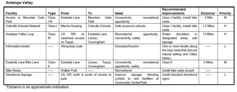
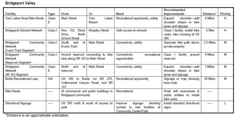
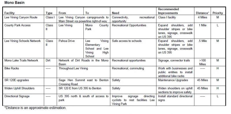
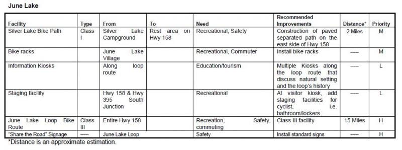
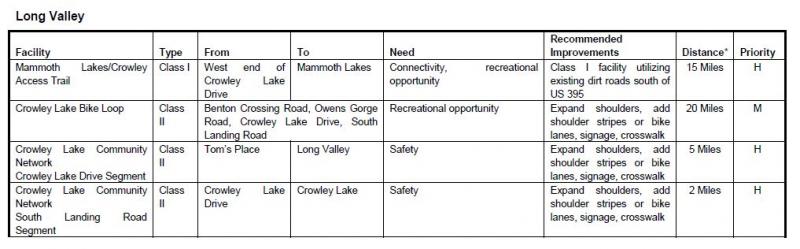
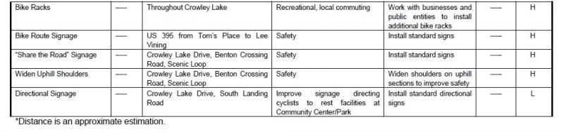
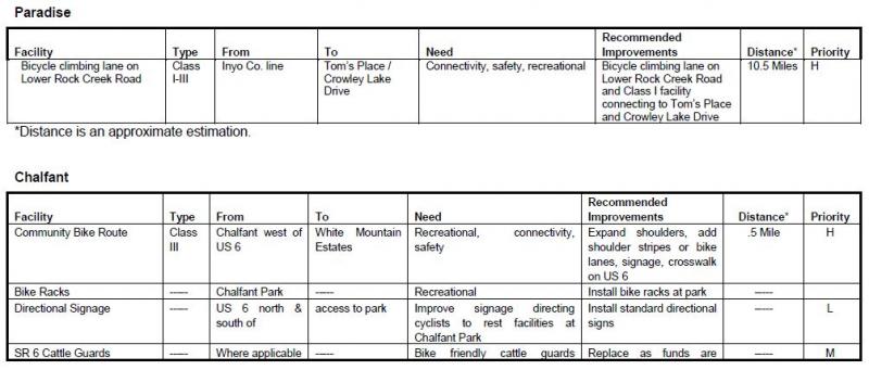
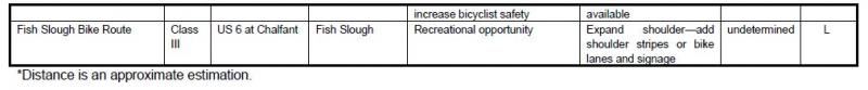
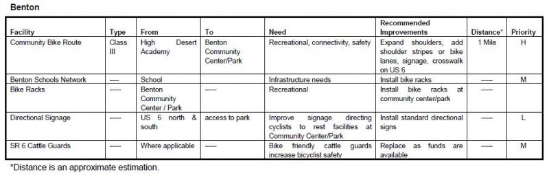
Chapter 6: Funding, Implementation, and Phasing
Estimated Project Costs
The Inyo County 2007/2008 Collaborative Bikeways Plan contains estimated costs for developing different types of bikeways. Those estimates will be utilized in this plan since development conditions are similar in the two counties. Some facilities may also be developed as regional facilities that are located in more than one county.
The Inyo County 2007/2008 Collaborative Bikeways Plan notes that:
These cost estimates are based on costs experienced in other California communities, recent cost estimates developed as part of traffic impact fee and mitigation analysis, and previous bikeway planning projects in the County of Yuba, City of Roseville, and City of Oakdale. The cost estimates include engineering, permitting, right-of-way, construction and inspection costs. These cost estimates should be used only to develop generalized construction cost estimates and project prioritization. More detailed estimates can be developed after preliminary engineering and design.
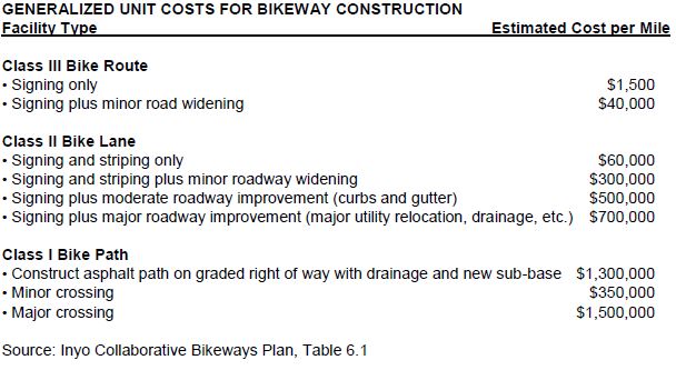
The unit costs identified in the above table have been applied to the proposed bikeway system. A summary of total system costs by facility type is presented in the table below.
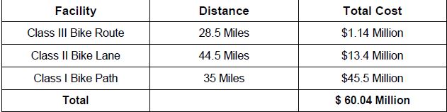
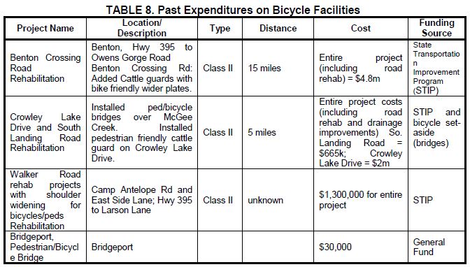
Funding Sources
Funding for bikeways and associated facilities is available from a number of federal and state programs. This section summarizes each of those sources. Generally, the local jurisdiction is responsible for applying for the funding identified below. Cooperative efforts among local agencies, such as the Forest Service, the County, and other local entities have been successful in obtaining funding for Mono County projects. It is important to note that many of these programs provide funding for the construction of bicycle facilities but not for on-going maintenance.
Federal Sources
Regional Surface Transportation Program (RSTP) – LTC, Caltrans
Provides funds for transportation projects on systems funded by federal-aid (functionally classified higher than local road or rural minor collector). Funds are available for bicycle and pedestrian facilities, transportation enhancement activities, and parking facilities (commuting and recreational programs).
Federal Safe Routes to Schools – Caltrans
For projects that connect schools and provide safe access for students (safety/education projects).
Recreational Trails Program – California Department of Parks & Recreation
For recreational trails to benefit bicyclists, pedestrians, and other users (recreational projects).
Transportation and Community and System Preservation Pilot Program – Federal Highway Administration
For projects that improve system efficiency and reduce the environmental impacts of transportation (commuting projects).
Land and Water Conservation Fund – California Dept. of Parks & Recreation
Projects that acquire and develop outdoor recreation areas and facilities (recreation projects).
State Sources
Safe Routes to School (SB 10) -- Caltrans
Provides funds for commuting, recreational use, and safety/education. Primarily intended for construction projects to enhance safety of pedestrian and bicycle facilities (commuting, recreation, safety/education projects).
Bicycle Transportation Account (BTA) -- Caltrans
Local jurisdictions must have a "Bicycle Transportation Plan" approved by CalTrans to submit applications. Project must conform to requirements of Caltrans Highway Design Manual, Chapter 1000. Intended for projects that improve the safety and convenience of bicycle commuters (commuting, safety/education projects).
Regional Transportation Improvement Program (RTIP) -- LTC
The local component of the State Transportation Improvement Program (STIP), the main transportation project funding source in the state. Projects must improve transportation within the region (commuting, safety/education projects).
Community Based Transportation Planning Demonstration Grant Program – Caltrans
For projects that exemplify livable community concepts (commuting projects).
Office of Traffic Safety Grants – Caltrans
May provide funds for bicycle and pedestrian projects (safety/education projects).
Active Transportation Program (ATP) – LTC, Caltrans
The ATP consolidates existing federal and state transportation programs, including the Transportation Alternatives Program (TAP), Bicycle Transportation Account (BTA), and State Safe Routes to School (SR2S), into a single program with a focus to make California a national leader in active transportation.
Other Sources
Funding may also be available from local agencies and private organizations. Recent cooperation between the U.S. Forest Service and the community of Lee Vining resulted in the construction of the Lee Vining community trail, and a local snowmobile enthusiasts groups have helped develop signed snowmobile trails on public lands.
In addition, it may be possible to obtain assistance from local groups and businesses in the construction and maintenance of bikeway facilities through a sponsorship program similar to the Adopt-A-Highway program implemented by Caltrans. For construction projects, assistance could be cash or the donation of goods and/or services; for maintenance activities, assistance may come from the donation of goods and/or services.
Appendix A: References
References Consulted
Bureau of Land Management (BLM)
Resource Management Plan for the Bishop Resource Area. 1991.
California Department of Transportation (Caltrans)
Highway Design Manual, Chapter 1000, Bikeway Planning and Design, 1/4/07.
Transportation Funding in California. 2007.
California Employment Development Department (EDD), Labor Market Information Division (LMID)
Mono County Profile. 2009.
Fehr and Peers, Transportation Consultants
Inyo County Collaborative Bikeways Plan. 2008.
Mono County Local Transportation Commission (LTC)
Mono County Regional Transportation Plan (RTP). 2008.
Mono County Planning Division
Mono County General Plan. 1993.
Mono County General Plan, Revised Land Use Element and Land Development Regulations. 2001.
Mono County Housing Element Update. 2009.
Mono County Master Environmental Assessment. 2001.
Mono County Trails Plan. 1994.
U.S. Forest Service (USFS)
Inyo National Forest Land and Resource Management Plan. 1988
Internet Reference Sites
The current internet address at the time of printing is listed for these sources; the address may have since changed.
California Department of Transportation (Caltrans)
Eastern Sierra Bicycle Guide, other Caltrans transportation planning documents.
California Department of Finance (DOF)
Demographic Research Unit, population and socio-economic statistics and forecasts, California Statistical Abstract.
Eastern Sierra Transit Authority (ESTA)
Information on transit services in the Eastern Sierra.
www.easternsierratransitauthority.com
Eastside Velo
Information on cycling in the Eastern Sierra.
Employment Development Department (EDD)
Labor market information, socioeconomic data, income and poverty statistics (Countywide level), occupational employment statistics.
www.labormarketinfo.edd.ca.gov
Sierra Cycling Foundation
Information on cycling in the Eastern Sierra.
www.sierracyclingfoundation.org
Town of Mammoth Lakes
Programs and policies in Mammoth Lakes.
U.S. Census Bureau
Population, housing, economic and social data from the 2000 Census, 5-year Economic Census, and other studies.
Utu Utu Gwaitu Paiute Tribe (Benton Paiute Reservation)
Information on tribal programs
www.bentonpaiutereservation.com
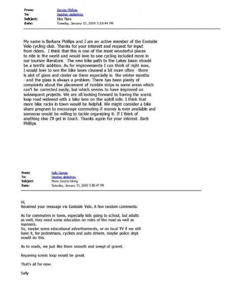
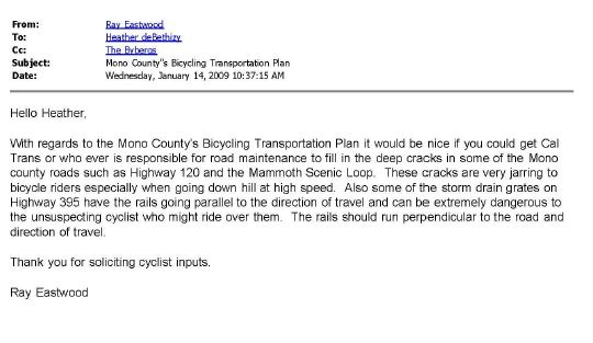
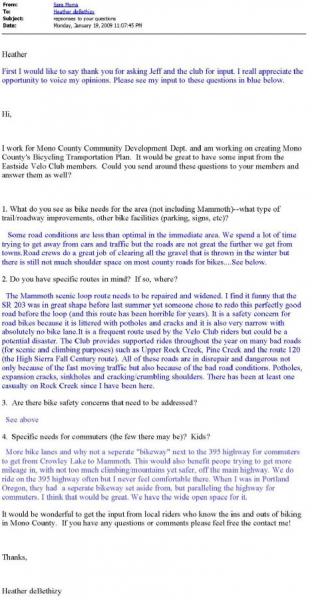
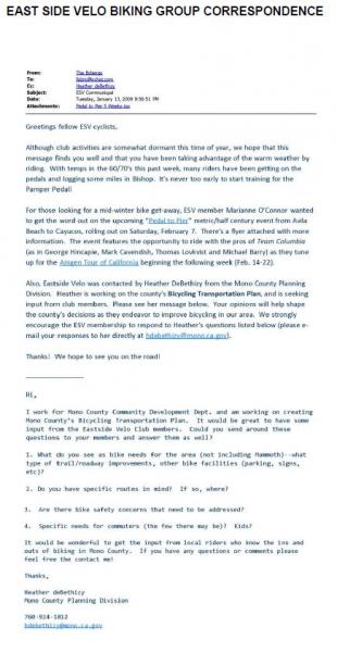
Appendix C: Maps
| Figure | Location/Area | Page |
| 3 | Antelope Valley | p54 |
| 4 | Bridgeport Valley/Twin Lakes | p55 |
| 5 | Bridgeport Community | p56 |
| 6 | Lee Vining Community | p57 |
| 7 | June Lake Loop | p58 |
| 8 | Long Valley | p59 |
| 9 | Benton Community | p60 |
FIGURE 3. Antelope Valley Bike Facilities Map
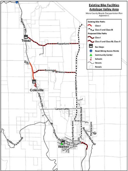
FIGURE 4. Bridgeport Valley/Twin Lakes Bike Facilities Map
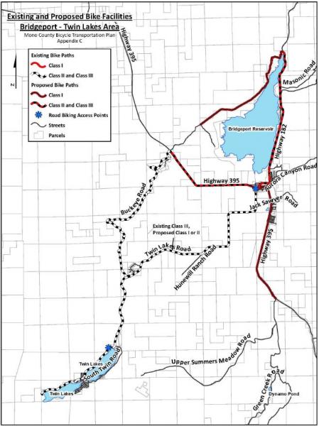
FIGURE 5. Bridgeport Community Bike Facilities Map
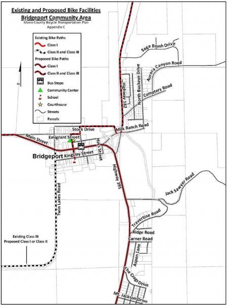
FIGURE 6. Lee Vining Community Bike Facilities Map
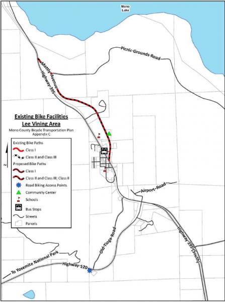
FIGURE 7. June Lake Loop Bike Facilities Map
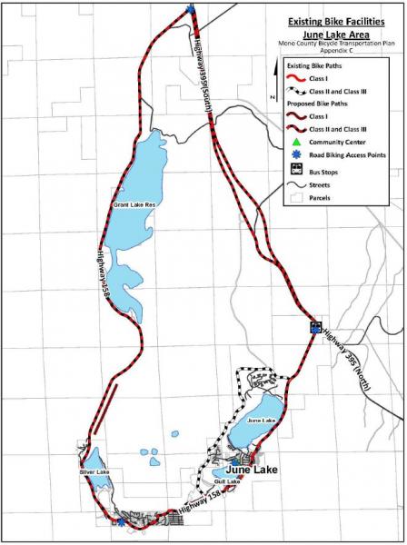
FIGURE 8. Long Valley Bike Facilities Map
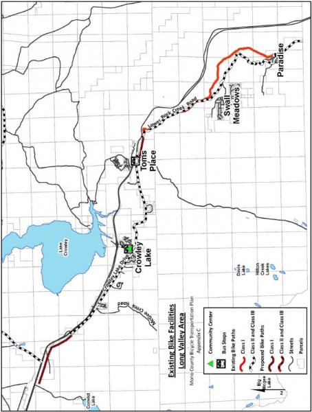
FIGURE 9. Benton Community Bike Facilities Map
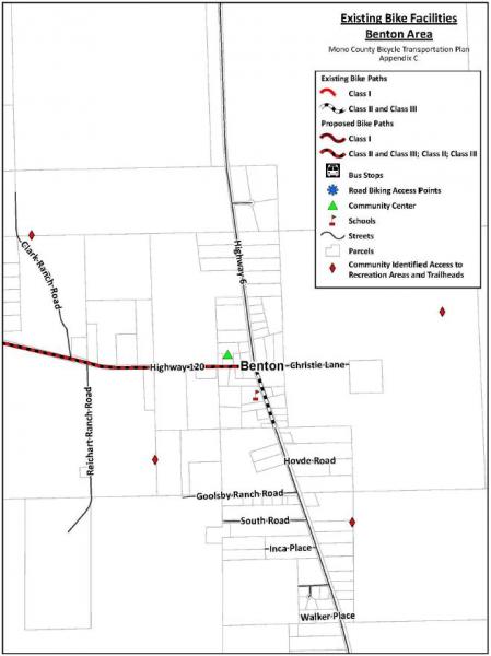
[1]Via searches on the American Fact Finder (U.S. Census website) at http://factfinder.census.gov/faces/nav/jsf/pages/index.xhtml and at http://factfinder.census.gov/faces/tableservices/jsf/pages/productview.x...